Stolac
Stolac
Столац | |
|---|---|
Town and municipality | |
 Stolac | |
 Flag  Seal | |
 Location of Stolac within Bosnia and Herzegovina. | |
| Coordinates: Coordinates: 43°04′57″N 17°57′21″E / 43.08250°N 17.95583°E | |
| Country | |
| Entity | Federation of Bosnia and Herzegovina |
| Canton | |
| Geographical region | Herzegovina |
| Government | |
| • Municipal mayor | Stjepan Bošković (HDZ BiH) |
| Area | |
| • Total | 331 km2 (128 sq mi) |
| Population (2013 census) | |
| • Total | 14,889 |
| • Density | 45/km2 (120/sq mi) |
| Time zone | UTC+1 (CET) |
| • Summer (DST) | UTC+2 (CEST) |
| Area code(s) | +387 36 |
| Website | Official website |

Stolac (Serbian Cyrillic: Столац) is a town and municipality located in Herzegovina-Neretva Canton of the Federation of Bosnia and Herzegovina, an entity of Bosnia and Herzegovina. It is located in the region of Herzegovina.
Stolac is situated in the area known as Herzegovina Humina on the tourist route crossing Herzegovina and linking the Bosnian mountainous hinterland with the coastal regions of Bosnia and Herzegovina, Dubrovnik, and Montenegro. The road, running from Sarajevo via Mostar, Stolac, Ljubinje, and Trebinje, enables one to reach Dubrovnik in less than 4 hours.[1]
Thanks to the town's favorable natural environment - geological composition, contours, climate, hydrographic, and vegetation - Stolac and its area have been settled since ancient times. Its rich hunting-grounds along with other natural benefits attracted prehistoric man, and later the Illyrians, Romans, and Slavs, all of whom left a wealth of anthropological evidence.[2]
In 2022 the new modern road consisting of 36 km that will connect the heart of Herzegovina with the sea, Stolac with Neum, will be completed. The road will help the development of tourism between Neum, Stolac, and Mostar.
History[]
This section does not cite any sources. (April 2018) |
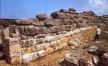
The area has been settled for at least 15,000 years, as evidenced by the markings in Badanj Cave, which experts have dated 12,000–16,000 BCE. Three kilometers west of Stolac is an impressive stećak necropolis dating back to the 15th and 16th centuries: Radimlja.
These stećak tombstones are carved with epitaphs, detailed portraits of the deceased, and motifs such as grapevines, hunting scenes, and wild animals. Five of the Radimlja tombstones are thought to mark the graves of members of the Hrabren Miloradović Valachian family.
Ali-paša Rizvanbegović (1783–1851), the semi-independent ruler (vizier) of Ottoman Herzegovina from 1833 to 1851, was born in the Begovina neighbourhood of Stolac.
Architecture[]

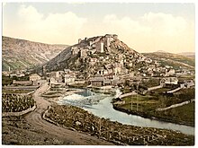
Containing, in one small area, unique cultural and aesthetic values, Stolac's historic core is an example of a complex cultural-historical and natural environmental ensemble. It is an example of the organic connection between human and natural architectures, which also testifies to the fact that the beauty of the location was crucial in its building and planning - the guiding principle often present in the development of medieval towns.
Nine historical layers compose Stolac's architectural ensemble: pre-history, Illyrian-Roman period, the early Middle Ages, advanced and late Middle Ages, Ottoman period, Austro-Hungarian period, and the time of the first and second Yugoslavia. A multitude of various influences on the architecture of the town, in which contrasts and similarities are frequently evident as well as planning and full spontaneity, lend this town a complex image. Despite its unusual history and inclusion into four empires (Roman, Byzantine, Ottoman, and Austro-Hungarian), three kingdoms (Bosnian, Hungarian and Yugoslav), three world's monotheistic religions - Christianity (Orthodox Christianity and Catholicism), Islam, and Judaism, the historical core of Stolac is still a coherent and harmonious cultural-historical monument with individual properties grown together into one ensemble.[2]
During the Yugoslav Wars, a number of monuments were demolished by Croat extremists as part of a campaign of ethnic cleansing, including the town's four mosques, dating from the 16th to 18th centuries, and the Orthodox Church of the Holy Assumption of Christ.[3]
In 2003 the Commission to Preserve National Monuments of Bosnia and Herzegovina designated Stolac Old Town as a National Monument of Bosnia and Herzegovina. Article 3 of that decision provides that “only research and conservation work and rehabilitation and restoration works, shall be allowed to be carried out, including the works aimed at promoting the National Monument” and “no buildings or any temporary and permanent structures shall be allowed to be constructed and erected at the site of the national monument unless their sole purpose is to protect and promote the monument.”
"Way of the Cross"[]

During war-time HVO control, city authorities controlled by HDZ BiH decided to build 14 crosses marking the “Stations of the Cross” within Old Town Stolac. They started from the Old Town Fortress, ultimately constructing eight wooden crosses. In 2002, they replaced the first wooden cross with a four-meter high stone cross, despite objections from the Commission to Preserve National Monuments of Bosnia and Herzegovina, which in 2003 designated the whole old town as National Monument. The following year, city authorities started replacing the other wooden crosses with concrete crosses. The Federation Ministry for Spatial Planning ordered the removal of the concrete crosses and the halting of works. This decision has never been implemented.
The saga restarted in 2019 when the Catholic Church Parish Office of St. Elias the Prophet in Stolac decided to build an additional six crosses to complete the “Stations of Cross.” The Stolac Municipal Council greenlighted the project in November. Mayor Boskovic claims the six crosses fall in the second zone of the protected area and do not desecrate the monument and that the municipality has a positive opinion from the Herzegovina-Neretva Canton's Institute for Protection of National Monuments. The new construction commenced in early 2020 but was called off due to the COVID-19 pandemic. In February, the Federation Inspectorate ordered the removal of all 14 cross foundations. Stolac Municipality appealed the decision, and on 16 March the Federation Ministry for Spatial Planning annulled the Inspectorate's decision, stating that the first instance body had “wrongly established the factual situation.” Construction of the six new crosses resumed on 29 June 2020.
Tourist attractions[]
Notable people[]
- Mak Dizdar (1917–1971), poet
- Asaf Duraković (1940–2020), physician and poet
- Nijaz Duraković (1949–2012), university professor, founder of Social-Democratic Party of Bosnia and Herzegovina, war-time Bosniak member of rotating presidency of Bosnia and Herzegovina
- Mustafa Golubić (1889/1891–1941), member of Young Bosnia
- Alija Isaković (1932–1997), writer, publicist and playwright
- Jazzar Pasha (1720/30s – 1804) converted to Islam and became the Ottoman governor of Sidon (1776–1804)
- Muhamed Mehmedbašić (1887–1943), member of Young Bosnia
- Ali Pasha Rizvanbegović (1783–1851), administrator of Stolac from 1813–33
- Zdravko Šotra (born 1933), film director
- Nikola Katić (born 1996), Croatian soccer player
Demographics[]
Population[]
| Population of settlements – Stolac municipality | |||||
|---|---|---|---|---|---|
| Settlement | 1971. | 1981. | 1991. | 2013. | |
| Total | 19,230 | 18,910 | 18,681 | 14,889 | |
| 1 | Aladinići | 747 | 1,234 | ||
| 2 | Bjelojevići | 325 | 229 | ||
| 3 | Borojevići | 717 | 601 | ||
| 4 | Burmazi | 369 | 223 | ||
| 5 | Crnići-Greda | 658 | 1,501 | ||
| 6 | Crnići-Kula | 628 | 570 | ||
| 7 | Hodovo | 418 | 377 | ||
| 8 | Kruševo | 300 | 241 | ||
| 9 | Ošanjići | 1,102 | 1,004 | ||
| 10 | Pješivac-Greda | 512 | 417 | ||
| 11 | Pješivac-Kula | 823 | 744 | ||
| 12 | Poplat | 457 | 1,402 | ||
| 13 | Poprati | 340 | 250 | ||
| 14 | Prenj | 790 | 684 | ||
| 15 | Rotimlja | 718 | 683 | ||
| 16 | Stolac | 3,809 | 5,210 | 5,530 | 3,816 |
| 17 | Trijebanj | 352 | 278 | ||
Ethnic composition[]
Following the Dayton peace treaty, the territory of the 1991 municipality of Stolac was divided between the municipality of Stolac in the Federation of Bosnia and Herzegovina and the new municipality of Berkovići in Republika Srpska, where most of the Bosnian Serbs from Stolac now reside.
| Ethnic composition – Stolac town | |||||||
|---|---|---|---|---|---|---|---|
| 2013. | 1991. | 1981. | 1971. | ||||
| Total | 3,816 (100,0%) | 5,530 (100,0%) | 5,210 (100,0%) | 3,809 (100,0%) | |||
| Bosniaks | 2,647 (69,37%) | 3,426 (61,95%) | 3,113 (59,75%) | 2,437 (63,98%) | |||
| Croats | 892 (23,38%) | 653 (11,81%) | 586 (11,25%) | 421 (11,05%) | |||
| Serbs | 144 (3,774%) | 1,111 (20,09%) | 982 (18,85%) | 846 (22,21%) | |||
| Others | 133 (3,485%) | 101 (1,826%) | 8 (0,154%) | 22 (0,578%) | |||
| Yugoslavs | 239 (4,322%) | 486 (9,328%) | 43 (1,129%) | ||||
| Montenegrins | 28 (0,537%) | 35 (0,919%) | |||||
| Albanians | 5 (0,096%) | 5 (0,131%) | |||||
| Macedonians | 2 (0,038%) | ||||||
| Ethnic composition – Stolac municipality | |||||||
|---|---|---|---|---|---|---|---|
| 2013. | 1991. | 1981. | 1971. | ||||
| Total | 14,889 (100,0%) | 18,681 (100,0%) | 18,910 (100,0%) | 19,230 (100,0%) | |||
| Croats | 8,486 (58,52%) | 6,188 (33,12%) | 6,410 (33,90%) | 7,041 (36,61%) | |||
| Bosniaks | 5,544 (38,23%) | 8,101 (43,36%) | 7,359 (38,92%) | 7,113 (36,99%) | |||
| Serbs | 279 (1,924%) | 3,917 (20,97%) | 4,332 (22,91%) | 4,900 (25,48%) | |||
| Others | 193 (1,331%) | 168 (0,899%) | 49 (0,259%) | 56 (0,291%) | |||
| Yugoslavs | 307 (1,643%) | 711 (3,760%) | 63 (0,328%) | ||||
| Montenegrins | 33 (0,175%) | 50 (0,260%) | |||||
| Roma | 7 (0,037%) | ||||||
| Albanians | 6 (0,032%) | 6 (0,031%) | |||||
| Macedonians | 3 (0,016%) | 1 (0,005%) | |||||
Settlements of Stolac municipality, 1991[]
Aladinići, Barane, Berkovići, Bitunja, Bjelojevići, Borojevići, Brštanik, Burmazi, Crnići-Greda, Crnići-Kula, Dabrica, Do, Hatelji, Hodovo, Hrgud, Komanje Brdo, Kozice, Kruševo, Ljubljenica, Ljuti Do, Meča, Orahovica, Ošanići, Pješivac-Greda, Pješivac-Kula, Poplat, Poprati, Predolje, Prenj, Rotimlja, Stolac, Strupići, Suzina, Šćepan Krst, Trijebanj, Trusina and Žegulja.
Climate[]
Climate in this area has mild differences between highs and lows, and there is adequate rainfall year-round. The Köppen Climate Classification subtype for this climate is "Cfa" (Humid subtropical climate).[4]
| hideClimate data for Stolac | |||||||||||||
|---|---|---|---|---|---|---|---|---|---|---|---|---|---|
| Month | Jan | Feb | Mar | Apr | May | Jun | Jul | Aug | Sep | Oct | Nov | Dec | Year |
| Average high °C (°F) | 9 (48) |
11 (51) |
15 (59) |
19 (67) |
24 (75) |
29 (85) |
33 (92) |
33 (91) |
28 (82) |
22 (71) |
16 (60) |
9 (49) |
21 (69) |
| Average low °C (°F) | 3 (37) |
2 (36) |
6 (43) |
9 (48) |
13 (55) |
17 (62) |
19 (66) |
19 (66) |
16 (61) |
12 (54) |
9 (48) |
4 (39) |
11 (51) |
| Average precipitation cm (inches) | 13 (5) |
12 (4.7) |
13 (5.2) |
13 (5.2) |
7.9 (3.1) |
8.4 (3.3) |
4.8 (1.9) |
4.3 (1.7) |
10 (4) |
17 (6.5) |
19 (7.3) |
18 (7.2) |
140 (55.1) |
| Source: Weatherbase [5] | |||||||||||||
See also[]
References[]
- ^ "www.stolac.org is Expired or Suspended". www.stolac.org.
- ^ Jump up to: a b The natural and architectural ensemble of Stolac, unesco.org; accessed 4 November 2016.
- ^ Robert Bevan, The Destruction of Memory, pp. 47-47
- ^ Climate Summary for Stolac, weatherbase.com; accessed 3 April 2018.
- ^ "Weatherbase.com". Weatherbase.com. 2013. Retrieved 13 July 2013.
External links[]
| Wikimedia Commons has media related to Stolac Municipality. |
| show Municipalities of the Herzegovina-Neretva Canton |
|---|

| show Authority control |
|---|
- Stolac
- Cities and towns in the Federation of Bosnia and Herzegovina
- Populated places in Stolac
- National Monuments of Bosnia and Herzegovina
- World Heritage Tentative List for Bosnia and Herzegovina