Subotiv
show This article may be expanded with text translated from the corresponding article in Ukrainian. (May 2021) Click [show] for important translation instructions. |
Subotiv
Суботів | |
|---|---|
village | |
 Flag  Coat of arms | |
 Subotiv | |
| Coordinates: 49°05′46″N 32°33′20″E / 49.09611°N 32.55556°E | |
| Country | |
| Oblast | |
| Raion | Cherkasy Raion |
| Founded | 1616 |
| Government | |
| • Village head | Ivan Hryshko |
| Elevation | 83 m (272 ft) |
| Population | |
| • Total | 875 |
| Time zone | UTC+2 (EET) |
| • Summer (DST) | UTC+3 (EEST) |
| Postal code | 20940 |
| Area code(s) | +380 47-3093 |
| Website | Verkhovna Rada website |


Subotiv (Ukrainian: Суботів) is a village (selo) in central Ukraine. It is located in Cherkasy Raion (district) of Cherkasy Oblast (province), near the town of Chyhyryn. It belongs to , of which the administration is located in Chyhyryn.[1]
Until 18 July 2020, Subotiv was in Chyhyryn Raion. The raion was abolished in July 2020 as part of the administrative reform of Ukraine, and its area was merged into Cherkasy Raion.[2][3]
The village is located on the right bank of the Tiasmyn River, a tributary of the Dnieper, 7 km from Chyhyryn, 21 km from Adamivka river port, and 38 km from Fundukliivka railway station. A local auto road 2414 runs through the village.
The village name, Subotiv, according to one legend, took its roots from a live fire from oak firewood (known as "subotka") that was in front of Perun. According to another legend, it came from the name of the place where water from two tributaries combines (known as "subod'").
Subotiv is the birthplace of the Ukrainian Hetman Bohdan Khmelnytsky.
History[]
Based on archeological studies, the place was settled as early as Bronze Age. At the place there are also traces of Early Slavic, and Kiev Rus settlements. In the documents the first known reference to the village is dated back to early 17th century.
Famous places[]
- , a church built by the order of Bohdan Khmelnytsky in 1653. It is also the place where Khmelnytsky is buried. The church is pictured on one of the paintings by Taras Shevchenko in 1845. The church is also pictured on 5 hryvnia banknote, which is currently in circulation in Ukraine.

A church in Subotiv near Chyhyryn, the birthplace of Ukrainian Hetman Bohdan Khmelnytsky.
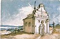
Taras Shevchenko. Bohdan's church in Subotiv. 1845. Paper. Water-colour.

The Subotiv church on a Hryvnia banknote.


References[]
- ^ "Чигиринская громада" (in Russian). Портал об'єднаних громад України.
- ^ "Про утворення та ліквідацію районів. Постанова Верховної Ради України № 807-ІХ". Голос України (in Ukrainian). 2020-07-18. Retrieved 2020-10-03.
- ^ "Нові райони: карти + склад" (in Ukrainian). Міністерство розвитку громад та територій України.
| show Authority control |
|---|
Coordinates: 49°05′46″N 32°33′20″E / 49.09611°N 32.55556°E
- Villages in Cherkasy Oblast