Sudbourne
| Sudbourne | |
|---|---|
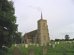 All Saints' Church, Sudbourne | |
 Sudbourne Location within Suffolk | |
| Population | 309 (2011)[1] |
| District |
|
| Shire county | |
| Region | |
| Country | England |
| Sovereign state | United Kingdom |
| Post town | Woodbridge |
| Postcode district | IP12 |
| UK Parliament | |

Sudbourne is a village and civil parish in Suffolk, England, located approximately 2 miles (3 km) north of Orford.
All Saints' Church dates from the 14th century but was much restored in 1879. It is a grade II* listed building.[2]
According to Sam Newton, Sudbourne was the location of the almost forgotten Battle of Newmouth between the English and the Danes in the early eleventh century.[3]
During World War II Sudbourne and the neighbouring village of Iken were used as a battle training area in advance of the D-Day landings in June 1944. The inhabitants were relocated returning sometime after the war finished.[4]
Sudbourne has Captain's Wood, a nature reserve owned by Suffolk Wildlife Trust, and Crag Farm Pit which is listed as a Site of Special Scientific Interest in Suffolk. Sudbourne is also the birthplace of Sir Thomas Rush.
References[]
- ^ "Parish population 2011". Retrieved 16 September 2015.
- ^ Historic England. "CHURCH OF ALL SAINTS (1030844)". National Heritage List for England. Retrieved 3 April 2014.
- ^ Suffolk Institute, "THE BATTLE OF NEWMOUTH AND THE LOST VIKING HISTORY OF SUDBOURNE,WITH A POSTSCRIPT ON THE PLACE-NAME ORFORD"
- ^ Simper, Robert (1995). Rivers Alde,Ore and Blythe. UK: Creekside Publishing. p. 56. ISBN 0 9519927 3 2.
External links[]
| Wikimedia Commons has media related to Sudbourne. |
- Sudbourne Parish Council website
- All Saints Church, Sudbourne
- Sudbourne & Tunstall Baptist Church website
- Suffolk Wildlife Trust - Captain's Wood
| Boroughs or districts |
|
|---|---|
| Major settlements | |
| Topics | |
This Suffolk location article is a stub. You can help Wikipedia by . |
- East Suffolk (district)
- Villages in Suffolk
- Civil parishes in Suffolk
- Suffolk geography stubs