Surduc
Surduc | |
|---|---|
 | |
 Location in Sălaj County | |
 Surduc Location in Romania | |
| Coordinates: 47°15′18″N 23°20′52″E / 47.25500°N 23.34778°ECoordinates: 47°15′18″N 23°20′52″E / 47.25500°N 23.34778°E | |
| Country | Romania |
| County | Sălaj |
| Established | 1320 (first mention as Sumbur)[1] |
| Government | |
| • Mayor (2020–2024) | Alin Băbănaș[2] (PNL) |
| Area | 71.42 km2 (27.58 sq mi) |
| Elevation | 607 m (1,991 ft) |
| Population (2011)[3] | 3,461 |
| • Density | 48/km2 (130/sq mi) |
| Time zone | EET/EEST (UTC+2/+3) |
| Postal code | 457315 |
| Vehicle reg. | SJ |
| Website | www |

Surduc (Hungarian: Szurduk, also Nagyszurduk)[1] is a commune located in Sălaj County, Transylvania, Romania. It is composed of seven villages: Brâglez (Tótszállás), Cristolțel (Kiskeresztes), Solona (Szalonnapatak), Surduc, Teștioara (Kőszénbányatelep), Tihău (Tihó) and Turbuța (Turbóca). It borders to the northwest with Jibou, to the north with Băbeni, to the southeast with Lozna, to the south with Cristolț and Gârbou, and to the southwest with Bălan.
Etymology[]
The name of the commune has its origin in the morphological configuration of the area (surduc means gorge, pass or narrow valley with sudden and steep slopes).[4] Other sources say that the name of the commune is of Slavic origin, surdec meaning meander; near Surduc, Someș makes the biggest turn in its course.[5] According to a local legend, between Bălan and Solona (the oldest villages in the area) there were no settlements but only an inn, in the place called sub grădiște (under the hillock), owned by a short and deaf man (in Romanian surd means deaf). The travelers nicknamed him "surduc", hence the name.[6]
History[]

Surduc is probably the successor of an older settlement, recorded as Sumbur in 1320.[1] Surduc is documented since 1554, when it appears as Naghzwrdok. Their documentary attestations accrue from years 1625 Nagi Szendok, 1630 Nagy-Szurduk, 1733 Szurduk, 1850 Szurdok, Szurduku, 1854 Szurduk, Surduc, 1930 Surduc, 1966 Surduc. Nevertheless, the first documentary attestation of Turbuța dates from 1387, when the village appears as villa olachalis Torbicza.[7] The estate and the village were owned at that time by Imre Balassa's widow, Anna Somi.[8] Between 1641 and 1810 it was owned by the Csáky family. They built here a mansion; only its servants' house is preserved to this day.[9] In 1705 it hosted Prince Francis II Rákóczi, before the confrontation of his troops with the Habsburg Imperial Army led by Ludwig von Herbeville in Zsibó (present-day Jibou).[7] The mansion was probably transformed into a castle in the 18th century, because at the beginning of the 19th century it was already recorded as a castle.[9] In 1810 it became the property of the Jósika family.[9] The writer Miklós Jósika, the founder of the Hungarian romantic novel, lived and worked here until 1853.[10]
Prior to the Treaty of Trianon, Surduc belonged to the Csákigorbó District of Szolnok-Doboka County.[11]
Geography[]
Relief[]
With an area of 71.42 km2 (6th among the county communes), Surduc occupies a central-eastern position within Sălaj County, at the contact of four important relief units: Someș Corridor, Șimișna–Gârbou Hills, Almaș–Agrij Depression and Prisnel Peak.[12] The commune is located to the east of the "intracarpathian yoke" (Meseș Mountains–Dumbrava Hill–Prisnel Peak).[12] The Șimișna–Gârbou Hills that make up most of the commune are represented only by their northern termination, which gradually inclines in this direction towards the wide terraced corridor of the Someș, to which the Almaș–Agrij Depression also opens.[12] The corridor is limited to the west by the last extensions of the Prisnel Peak, represented by the Rona Peak (438 m).[12]
The relief is very varied, formed by an association of hilly peaks and valleys between slopes, all resulting from the fragmentation of the northwestern part of the Someș Plateau.[13] In terms of altitude, the relief is between about 200 m in the meadows of Someș and its tributaries and 607 m in Pietrosu Peak, in the southeastern part of the commune.[13]
Hydrography[]
The hydrographic network is relatively young in age. The territory of the commune is crossed by the middle course of the Someș, as well as three smaller tributaries of it: Valea Cristolțelului (Solonii), Valea Brâglezului (Gârboului) și Valea Almașului. The average density of the river network (taking into account the length of temporary valleys) is 0.39 km/km².[13]
Flora and fauna[]
The fragmented plateau relief and the climate allowed the development of a predominantly forest vegetation, in which the Turkey oak and the Hungarian oak predominate. In the distribution of the floristic elements there is a weak vertical zonation, in the sense that the forested surfaces (beech, oak and mixed forests) are interspersed with secondary and derived grasslands or with agricultural lands.[13]
In the forest floor there is a great diversity of animal species, from the evolved ones (mammals) to the smallest invertebrates. Among the larger mammals, some of which are of hunting interest, are: wolves, foxes, deers, badgers, rabbits, etc.[13] Rodent mammals are represented by wood mouses, squirrels and edible dormice.[13] The avifauna is very varied and represented by: tits, jays, blackbirds, nightingales, woodpeckers, orioles, sparrowhawks, kites, crows, ravens, magpies, etc.[13] Among the reptiles are common species such as slowworm, green lizard and common frog.[13] The aquatic fauna is represented, especially in Valea Gârboului, by invertebrates (crustaceans, worms, mollusks, etc.), as well as by small fish.[13]
Climate[]
Like all of Romania, Surduc exhibits a temperate continental climate. The climate here is classified as Cfb by the Köppen-Geiger system.[14] The temperature here averages 10 °C. With an average of 20.9 °C, August is the warmest month. January is the coldest month, with temperatures averaging –2.0 °C.[14] In a year, the rainfall is 756 mm. The driest month is February. There is 45 mm of precipitation in February. Most of the precipitation here falls in June, averaging 89 mm.[14]
| Climate data for Surduc, Sălaj | |||||||||||||
|---|---|---|---|---|---|---|---|---|---|---|---|---|---|
| Month | Jan | Feb | Mar | Apr | May | Jun | Jul | Aug | Sep | Oct | Nov | Dec | Year |
| Average high °C (°F) | 1.4 (34.5) |
4.0 (39.2) |
9.6 (49.3) |
15.9 (60.6) |
20.5 (68.9) |
23.8 (74.8) |
25.6 (78.1) |
25.9 (78.6) |
20.8 (69.4) |
14.9 (58.8) |
9.1 (48.4) |
2.8 (37.0) |
14.5 (58.1) |
| Daily mean °C (°F) | −2.0 (28.4) |
−0.1 (31.8) |
4.6 (40.3) |
10.6 (51.1) |
15.5 (59.9) |
19.1 (66.4) |
20.8 (69.4) |
20.9 (69.6) |
15.8 (60.4) |
10.1 (50.2) |
5.1 (41.2) |
−0.3 (31.5) |
10.0 (50.0) |
| Average low °C (°F) | −5.2 (22.6) |
−3.9 (25.0) |
−0.4 (31.3) |
4.8 (40.6) |
9.6 (49.3) |
13.4 (56.1) |
15.4 (59.7) |
15.4 (59.7) |
10.9 (51.6) |
5.8 (42.4) |
1.7 (35.1) |
−3.0 (26.6) |
5.4 (41.7) |
| Average precipitation mm (inches) | 48 (1.9) |
45 (1.8) |
56 (2.2) |
64 (2.5) |
76 (3.0) |
89 (3.5) |
82 (3.2) |
60 (2.4) |
68 (2.7) |
59 (2.3) |
53 (2.1) |
56 (2.2) |
756 (29.8) |
| Average precipitation days | 7 | 8 | 8 | 8 | 9 | 9 | 8 | 7 | 7 | 7 | 7 | 8 | 93 |
| Average relative humidity (%) (daily average) | 81 | 78 | 71 | 66 | 68 | 68 | 68 | 65 | 69 | 75 | 79 | 82 | 73 |
| Source: [14] | |||||||||||||
Demographics[]
Religious composition
| Census | Ethnic composition[15] | ||||||||
|---|---|---|---|---|---|---|---|---|---|
| Year | Population | Romanians | Hungarians | Germans | Jews | Roma | |||
| 1850 | 2,646 | 2,423 | 61 | 5 | 46 | 70 | |||
| 1880 | 2,616 | 2,313 | 143 | 12 | |||||
| 1890 | 2,920 | 2,630 | 208 | 38 | |||||
| 1900 | 3,108 | 2,830 | 248 | 27 | |||||
| 1910 | 3,841 | 3,371 | 396 | 56 | |||||
| 1920 | 3,743 | 3,376 | 181 | 10 | 117 | ||||
| 1930 | 4,707 | 4,091 | 312 | 15 | 134 | 105 | |||
| 1941 | 4,891 | 4,244 | 434 | 12 | 56 | 137 | |||
| 1956 | 5,671 | 5,553 | 117 | ||||||
| 1966 | 5,516 | 5,428 | 67 | 2 | 16 | ||||
| 1977 | 4,805 | 4,734 | 28 | 2 | 39 | ||||
| 1992 | 4,323 | 4,198 | 9 | 1 | 114 | ||||
| 2002 | 4,026 | 3,908 | 11 | 106 | |||||
| 2011 | 3,461 | 3,164 | 10 | 211 | |||||
| Censuses in italics are based on mother tongue rather than ethnicity. | |||||||||
According to the 2011 census, the population of Surduc is 3,461 inhabitants,[16] down from the previous census in 2002, when 4,026 inhabitants were registered.[17] The majority of the inhabitants are Romanian (91.41%). The main minorities are Roma (6.09%) and Hungarians (0.28%). For 2.22% of the population, ethnicity is unknown.[18]
In terms of religion, most of the inhabitants are Orthodox (86.99%), but there are also minorities of Pentecostals (3.84%), Jehovah's Witnesses (2.83%) and Greek Catholics (2.69%). For 2.13% of the population, confessional affiliation is not known.[19] In the commune there are six Orthodox churches (Surduc, Tihău, Brâglez, Cristolțel, Solona and Turbuța), a Greek Catholic church (Tihău), three Pentecostal places of worship (Surduc, Tihău and Solona) and two Baptist places of worship (Surduc and Turbuța).[20]
Politics and administration[]
Surduc is administered by a mayor and a local council composed of 13 councilors. The mayor, Alin Băbănaș, from the National Liberal Party, has been in office since 2016.[21] After the 2020 local elections, the local council has the following composition by political parties:[22]
| Party | Seats | Current council | |||||||
|---|---|---|---|---|---|---|---|---|---|
| PNL | 7 | ||||||||
| PSD | 5 | ||||||||
| PMP | 1 | ||||||||
Component villages[]
| Name in Romanian | Name in Hungarian[1] | Name in German[1] |
|---|---|---|
| Brâglez | Tótszállás | Bregler |
| Cristolțel | Kiskeresztes | |
| Solona | Szalonnapatak | |
| Surduc | Szurduk | |
| Teștioara | Kőszénbányatelep | Braunkohlebergwerk |
| Tihău | Tihó | |
| Turbuța | Turbóca |
Education[]
Surduc has a technological high school, resulting from the merger in 2009–2010 of the middle schools of Tihău, Cristolțel, Turbuța and Brâglez.[23] The first mentions about the high school date from 1867 when Gavril Balmoș was a "traveling teacher" in Surduc and Solona.[23] In 1894, with the contribution of the villagers, a private premises for the confessional school was built here.[23] The building for the state school and kindergarten, both intended for education in Hungarian, was built in 1900.[23] The state education in Romanian began in 1919, the first teacher being Teodor Panorariu.[23] Following the Second Vienna Award, in 1940–1944, education was conducted in Hungarian. Romanian-language education resumed in 1944–1945.[23] In 2015–2016 370 students were enrolled here.[24] Besides this, in the commune there are four kindergartens (Surduc, Tihău, Brâglez and Cristolțel) and two elementary schools (Tihău and Turbuța).[24]
Healthcare[]
Surduc has a family medicine office, a dental office and a pharmacy.[25]
Economy[]
The commune used to be prosperous. There were a brick and tile factory, a wood processing factory and two slaughterhouses.[6] Until after 1989, the commune's economy was supported by mining activities related to the exploitation of brown coal and gravel aggregates located in the meadows of Someș, Almaș and Brâglez rivers. In 1999, the Hida–Surduc–Jibou–Bălan mining area was declared, for a period of ten years, a disadvantaged area.[26]
Industry[]
There are industrial branches represented by some small and medium enterprises:[27]
- civil construction units: 2
- ore extraction and processing unit for the chemical industry: 1
- furniture production unit: 1
Agriculture[]
Agriculture is based on family-level production and takes place both in open field and vegetable gardens. Vegetable farming takes advantage of an area with a temperate climate and is thus varied and exclusively natural. Predominantly cultivated vegetable species are carrots, parsley, eggplants, onions, tomatoes, etc.[27] Fruit growing and viticulture do not enjoy a controlled exploitation.[27] Animal husbandry is a branch with potential, but unexploited. There are four milk collection/processing points.[27]
Tourism[]
Tourist spots[]
- Brâglez
- Presentation of Christ Church, built between 1929 and 1930[28]
- Michael's Cave, a small suspended abri which the locals call a cave, with an opening of 40–45 m, a height of 4–4.5 m and just as deep[29]
- House of robbers (Pintea Viteazu Cave), a sandstone bank whose vertical erosion created a 50–60 cm-wide and 3 m-high cave[30]
- Surduc
- Jósika Castle
- Crypt of the Jósika family. It was built in 1825 by Miklós Jósika in memory of his father.[31]
- St. John the Baptist Church. It was built between 1911 and 1913 on the site of a towerless wooden church built in 1850.[32]
- Jewish cemetery. The oldest known tomb dates from the 19th century.[33]
- Teștioara
- Tăul Iezer lake complex, with a rich lake vegetation[29]
- Tihău
- Roman castra. It is located on the left side of the Someș, on a plateau called Grădiște or Cetate.
- Turbuța
- Wooden church. It was built around the 17th–18th centuries.[34]
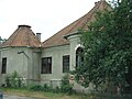
Jósika Castle in Surduc

Orthodox church in Surduc

Wooden church in Turbuța


Infrastructure[]
Surduc is crossed by the national roads DN1H and DN1G, as well as by 37.6 km of communal roads and 32.139 km of village roads.[35] Surduc railway station is transited daily by five trains to Jibou, Cluj-Napoca and Baia Mare.[36] Căile Ferate Române Line 400 passes through Surduc. The length of the railway in the commune is about 10 km.[35]
The commune has 32 km of drinking water supply network (put into operation in 1994) and 16.2 km of natural gas supply network (put into operation in 1999).[35] The commune does not have a sewerage network.[35]
Notable figures[]
- Miklós Jósika (1794–1865), soldier, politician and writer
- Vasile Pușcaș (b. 1952), politician, diplomat and professor
References[]
- ^ a b c d e "Surduc". Erdély, Bánság és Partium történeti és közigazgatási helységnévtára. Arcanum.
- ^ "Results of the 2020 local elections". Central Electoral Bureau. Retrieved 14 June 2021.
- ^ "Populaţia stabilă pe judeţe, municipii, oraşe şi localităti componenete la RPL_2011" (in Romanian). National Institute of Statistics. Retrieved 4 February 2014.
- ^ "Istoricul localității". Primăria comunei Surduc.
- ^ Chendre-Roman, Gheorghe (2006). Dicționar etimologic al localităților din județul Sălaj. Editura Caiete Silvane. ISBN 973-7817-41-9.
- ^ a b Cataramă, Diana (13 April 2016). "O viață trăită la sat: istorie și Holocaust". Go Free.
- ^ a b András, János. "Harmadik kötet Q-Zs". Tekintő. Erdélyi helynévkönyv (PDF). p. 1044. Archived from the original (PDF) on 2011-07-10.
- ^ Dîngă, Ioan; et al. (2014). "Personalități ale comunei Surduc" (PDF). Caravana Culturii Sălăjene. p. 4.
- ^ a b c "Castelul Jósika, Surduc". Welcome to Romania.
- ^ "Castelul Jósika, Surduc". Castel în Transilvania.
- ^ "Szurduk". Magyar Elektronikus Könyvtár.
- ^ a b c d "Primăria Surduc". Ghidul Primăriilor.
- ^ a b c d e f g h i "Date fizico-geografice". Primăria comunei Surduc.
- ^ a b c d "Surduc". Climate-Data.org.
- ^ Varga, E. Árpád. "Szilágy megye településeinek etnikai (anyanyelvi/nemzetiségi) adatai 1850-1992" (PDF). A Kulturális Innovációs Alapítvány Könyvtára. p. 92.
- ^ "Tab3. Populația stabilă pe sexe și grupe de vârstă – județe, municipii, orașe, comune". Institutul Național de Statistică.
- ^ "Structura etno-demografică pe arii geografice". Centrul de Resurse pentru Diversitate Etnoculturală.
- ^ "Tab8. Populația stabilă după etnie – județe, municipii, orașe, comune". Institutul Național de Statistică.
- ^ "Tab13. Populația stabilă după religie – județe, municipii, orașe, comune". Institutul Național de Statistică.
- ^ "Cultură și învățământ". Primăria comunei Surduc.
- ^ Negoiță, Florin (28 September 2020). "Alegeri locale 2020: lista primarilor din județul Sălaj". Magazin Sălăjean.
- ^ "Rezultatele finale ale alegerilor locale din 2020". Autoritatea Electorală Permanentă.
- ^ a b c d e f "Liceul Tehnologic Nr. 1 Surduc". Didactic.ro.
- ^ a b "Plan de acțiune al școlii" (PDF). Inspectoratul Școlar Județean Sălaj. 2016. pp. 31–33.
- ^ "Distribuția teritorială a furnizorilor de servicii medicale". Casa Județeană de Asigurări de Sănătate Sălaj.
- ^ "Hotărârea nr. 201/1999 privind declararea zonei miniere Hida-Surduc-Jibou-Bălan, județul Sălaj, ca zonă defavorizată". Lege5.
- ^ a b c d "Economie". Primăria comunei Surduc.
- ^ "Biserica Întâmpinarea Domnului". Biserici.org.
- ^ a b "TRASEE TURISTICE SĂLAJ – De la Peștera lui Mihai și abriurile din Valea Teștioarei la Tăurile Iezer din Teștioara și Casa Tâlharilor de lângă Brâglez (GALERIE FOTO)". eMM.ro. 27 April 2009.
- ^ Bălaș, Lucia; Bódis, Ottilia (2013). Sălaj - ghidul localităților (PDF). Zalău: Biblioteca Județeană „I. S. Bădescu”. p. 239. ISBN 978-973-0-24720-6.
- ^ "Cripta familiei Jósika, Surduc". Welcome to Romania.
- ^ "Biserica ortodoxă, Surduc". Welcome to Romania.
- ^ "SURDUC: Sălaj County". International Jewish Cemetery Project.
- ^ "Biserica de lemn, Turbuța". Welcome to Romania.
- ^ a b c d "Infrastructură". Primăria comunei Surduc.
- ^ "Surduc Sălaj Hm". Mersul trenurilor.
| Wikimedia Commons has media related to Surduc, Sălaj. |

- Communes in Sălaj County
- Localities in Transylvania