Suring, Wisconsin
Suring, Wisconsin | |
|---|---|
 Location of Suring in Oconto County, Wisconsin. | |
| Coordinates: 45°0′0″N 88°22′28″W / 45.00000°N 88.37444°WCoordinates: 45°0′0″N 88°22′28″W / 45.00000°N 88.37444°W | |
| Country | |
| State | |
| County | Oconto |
| Area | |
| • Total | 1.02 sq mi (2.66 km2) |
| • Land | 1.02 sq mi (2.66 km2) |
| • Water | 0.00 sq mi (0.00 km2) |
| Elevation | 801 ft (244 m) |
| Population | |
| • Total | 544 |
| • Estimate (2019)[4] | 522 |
| • Density | 509.27/sq mi (196.59/km2) |
| Time zone | UTC-6 (Central (CST)) |
| • Summer (DST) | UTC-5 (CDT) |
| Area code(s) | 920 |
| FIPS code | 55-78725[5] |
| GNIS feature ID | 1580561[2] |
| Website | www |

Suring is a village in Oconto County, Wisconsin, United States, along the 45th parallel. The population was 544 at the 2010 census. It is part of the Green Bay Metropolitan Statistical Area.
History[]
This area lies within the traditional homeland of the Menominee, who lived here for millennia before European arrival. After years of negotiations with the Ho-Chunk and the United States government about how to accommodate the incoming populations of Oneida, Stockbridge-Munsee, and Brothertown peoples following their removal from New York, the Menominee signed the 1836 Treaty of the Cedars and ceded this territory to the United States.[6] Following this land cession, white settlement could begin. A post office called Suring has been in operation since 1897.[7] The village was named in English for Julius "Joe" Suring (1852 – c. 1920),[8] a local landowner.[9][10] In the Menominee language, it is known as Naeqniw-Sīpiah 'three rivers'.[11]
Geography[]
Suring is located at 45°0′0″N 88°22′28″W / 45.00000°N 88.37444°W (45.000016, -88.374481).[12] Suring Wisconsin is Located Northwest of Greenbay Wisconsin 50.5 Miles.
According to the United States Census Bureau, the village has a total area of 1.01 square miles (2.62 km2), all of it land.[13] The Oconto River and Peshtigo Brook define its boundaries on the Southwest.
The village stresses its location on the 45th parallel north with a marker, placing it halfway between the equator, and the north pole.
Wisconsin Highway 32, conjoined with County highway M, passes through the village.
Demographics[]
| Historical population | |||
|---|---|---|---|
| Census | Pop. | %± | |
| 1920 | 294 | — | |
| 1930 | 421 | 43.2% | |
| 1940 | 437 | 3.8% | |
| 1950 | 546 | 24.9% | |
| 1960 | 513 | −6.0% | |
| 1970 | 499 | −2.7% | |
| 1980 | 581 | 16.4% | |
| 1990 | 626 | 7.7% | |
| 2000 | 605 | −3.4% | |
| 2010 | 544 | −10.1% | |
| 2019 (est.) | 522 | [4] | −4.0% |
| U.S. Decennial Census[14] | |||
2010 census[]
As of the census[3] of 2010, there were 544 people, 232 households, and 133 families living in the village. The population density was 538.6 inhabitants per square mile (208.0/km2). There were 268 housing units at an average density of 265.3 per square mile (102.4/km2). The racial makeup of the village was 90.4% White, 6.4% Native American, 0.9% from other races, and 2.2% from two or more races. Hispanic or Latino of any race were 1.7% of the population.
There were 232 households, of which 31.9% had children under the age of 18 living with them, 39.2% were married couples living together, 14.7% had a female householder with no husband present, 3.4% had a male householder with no wife present, and 42.7% were non-families. 39.2% of all households were made up of individuals, and 22.4% had someone living alone who was 65 years of age or older. The average household size was 2.17 and the average family size was 2.86.
The median age in the village was 43.2 years. 24.6% of residents were under the age of 18; 4.8% were between the ages of 18 and 24; 22.7% were from 25 to 44; 22.8% were from 45 to 64; and 25.2% were 65 years of age or older. The gender makeup of the village was 46.1% male and 53.9% female.
2000 census[]
As of the census[5] of 2000, there were 605 people, 252 households, and 147 families living in the village. The population density was 595.1 people per square mile (229.0/km2). There were 269 housing units at an average density of 264.6 per square mile (101.8/km2). The racial makeup of the village was 98.02% White, 0.17% African American, 1.32% Native American, 0.17% from other races, and 0.33% from two or more races. Hispanic or Latino of any race were 0.17% of the population.
There were 252 households, out of which 29.8% had children under the age of 18, 43.7% were married couples living together, 9.9% had a female householder with no husband present, and 41.3% were non-families. 36.9% of all households were made up of individuals, and 19.8% had someone living alone who was 65 years of age or older. The average household size was 2.17 and the average family size was 2.81.
In the village, the population was spread out, with 22.6% under the age of 18, 8.6% from 18 to 24, 23.1% from 25 to 44, 18.0% from 45 to 64, and 27.6% who were 65 years of age or older. The median age was 42 years. For every 100 females, there were 80.1 males. For every 100 females age 18 and over, there were 77.9 males.
The median income for a household in the village was $26,023, and the median income for a family was $38,125. Males had a median income of $28,182 versus $20,903 for females. The per capita income for the village was $14,230. About 10.5% of families and 12.4% of the population were below the poverty line, including 17.4% of those under age 18 and 9.3% of those age 65 or over.
Gallery[]
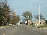
Downtown Suring

Downtown Suring
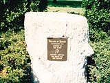
Geographic marker

Bridge


References[]
- ^ "2019 U.S. Gazetteer Files". United States Census Bureau. Retrieved August 7, 2020.
- ^ a b "US Board on Geographic Names". United States Geological Survey. 2007-10-25. Retrieved 2008-01-31.
- ^ a b "U.S. Census website". United States Census Bureau. Retrieved 2012-11-18.
- ^ a b "Population and Housing Unit Estimates". United States Census Bureau. May 24, 2020. Retrieved May 27, 2020.
- ^ a b "U.S. Census website". United States Census Bureau. Retrieved 2008-01-31.
- ^ "Menominee Treaties and Treaty Rights". Indian Country Wisconsin. Retrieved 2018-10-05.
- ^ "Oconto County". Jim Forte Postal History. Retrieved 21 March 2015.
- ^ "First Settler of Suring Is Buried". The Green Bay Press-Gazette. February 24, 1941. p. 4. Retrieved January 12, 2020 – via Newspapers.com.

- ^ Callary, Edward (2016). Place Names of Wisconsin. Madison, WI: University of Wisconsin Press. p. 267.
- ^ Chicago and North Western Railway Company (1908). A History of the Origin of the Place Names Connected with the Chicago & North Western and Chicago, St. Paul, Minneapolis & Omaha Railways. p. 128.
- ^ Hoffman, Mike. "Menominee Place Names in Wisconsin". The Menominee Clans Story. Retrieved 2018-10-05.
- ^ "US Gazetteer files: 2010, 2000, and 1990". United States Census Bureau. 2011-02-12. Retrieved 2011-04-23.
- ^ "US Gazetteer files 2010". United States Census Bureau. Archived from the original on 2012-07-02. Retrieved 2012-11-18.
- ^ "Census of Population and Housing". Census.gov. Retrieved June 4, 2015.
External links[]
Municipalities and communities of Oconto County, Wisconsin, United States | ||
|---|---|---|
| Cities |  | |
| Villages | ||
| Towns | ||
| CDPs | ||
| Other communities | ||
| Indian reservation | ||
| Footnotes | ‡This populated place also has portions in an adjacent county or counties | |
| ||
- Villages in Oconto County, Wisconsin
- Villages in Wisconsin
- Green Bay metropolitan area