Oconto County, Wisconsin
Oconto County | |
|---|---|
U.S. county | |
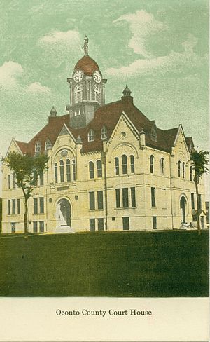 The Oconto County Court House, circa 1910 | |
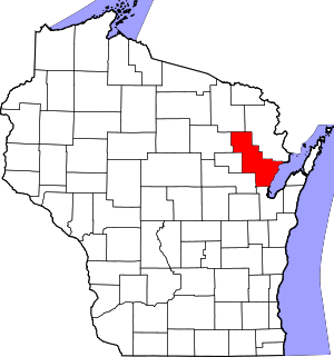 Location within the U.S. state of Wisconsin | |
 Wisconsin's location within the U.S. | |
| Coordinates: 44°59′N 88°14′W / 44.99°N 88.23°W | |
| Country | |
| State | |
| Founded | 1854 |
| Named for | Oconto River |
| Seat | Oconto |
| Largest city | Oconto |
| Area | |
| • Total | 1,149 sq mi (2,980 km2) |
| • Land | 998 sq mi (2,580 km2) |
| • Water | 151 sq mi (390 km2) 13%% |
| Population (2010) | |
| • Total | 37,660 |
| • Estimate (2020) | 38,383 |
| • Density | 33/sq mi (13/km2) |
| Time zone | UTC−6 (Central) |
| • Summer (DST) | UTC−5 (CDT) |
| Congressional district | 8th |
| Website | www |

Oconto County is a county in the U.S. state of Wisconsin. As of the 2010 census, the population was 37,660.[1] Its county seat is Oconto.[2] The county was established in 1851.[3]
Oconto County is part of the Green Bay, WI Metropolitan Statistical Area and the Green Bay-Shawano, WI Combined Statistical Area.
History[]
First visited by French explorers in the 17th century, Oconto County is among the oldest settlements in Wisconsin. Father Claude-Jean Allouez of the Roman Catholic Jesuit order said the first Mass in Oconto. Among the first settlers was Joseph Tourtilott, who explored much of the Oconto River watershed. Oconto County was created in 1851 and organized in 1854.[4]
Geography[]
According to the U.S. Census Bureau, the county has a total area of 1,149 square miles (2,980 km2), of which 998 square miles (2,580 km2) is land and 151 square miles (390 km2) (13%) is water.[5]
Adjacent counties[]
- Marinette County - northeast
- Brown County - south
- Shawano County - southwest
- Menominee County - west
- Langlade County - west
- Forest County - northwest
Major highways[]
 U.S. Highway 41
 U.S. Highway 141
 Highway 22 (Wisconsin)
 Highway 32 (Wisconsin)
 Highway 64 (Wisconsin)
Airport[]
J. Douglas Bake Memorial Airport (KOCQ) serves the county and surrounding communities.
National protected area[]
- Nicolet National Forest (part)
Demographics[]
| Historical population | |||
|---|---|---|---|
| Census | Pop. | %± | |
| 1860 | 3,592 | — | |
| 1870 | 9,321 | 159.5% | |
| 1880 | 9,848 | 5.7% | |
| 1890 | 15,009 | 52.4% | |
| 1900 | 20,874 | 39.1% | |
| 1910 | 25,657 | 22.9% | |
| 1920 | 27,104 | 5.6% | |
| 1930 | 26,386 | −2.6% | |
| 1940 | 27,075 | 2.6% | |
| 1950 | 26,238 | −3.1% | |
| 1960 | 25,110 | −4.3% | |
| 1970 | 25,553 | 1.8% | |
| 1980 | 28,947 | 13.3% | |
| 1990 | 30,226 | 4.4% | |
| 2000 | 35,634 | 17.9% | |
| 2010 | 37,660 | 5.7% | |
| 2020 (est.) | 38,383 | [6] | 1.9% |
| U.S. Decennial Census[7] 1790–1960[8] 1900–1990[9] 1990–2000[10] 2010–2020[1] | |||


As of the census[11] of 2000, there were 35,634 people, 13,979 households, and 10,050 families residing in the county. The population density was 36 people per square mile (14/km2). There were 19,812 housing units at an average density of 20 per square mile (8/km2). The racial makeup of the county was 97.76% White, 0.13% Black or African American, 0.78% Native American, 0.20% Asian, 0.01% Pacific Islander, 0.24% from other races, and 0.88% from two or more races. 0.67% of the population were Hispanic or Latino of any race. 42.9% were of German, 11.8% Polish, 6.0% French and 5.6% American ancestry.
There were 13,979 households, out of which 32.20% had children under the age of 18 living with them, 60.70% were married couples living together, 6.90% had a female householder with no husband present, and 28.10% were non-families. 23.50% of all households were made up of individuals, and 10.70% had someone living alone who was 65 years of age or older. The average household size was 2.52 and the average family size was 2.97.
In the county, the population was spread out, with 25.70% under the age of 18, 6.40% from 18 to 24, 28.70% from 25 to 44, 24.00% from 45 to 64, and 15.10% who were 65 years of age or older. The median age was 39 years. For every 100 females, there were 101.30 males. For every 100 females age 18 and over, there were 99.70 males.
In 2017, there were 353 births, giving a general fertility rate of 61.0 births per 1000 women aged 15–44, the 28th lowest rate out of all 72 Wisconsin counties.[12] Additionally, there were 14 reported induced abortions performed on women of Oconto County residence in 2017.[13]
Communities[]

Cities[]
- Gillett
- Oconto (county seat)
- Oconto Falls
Villages[]
- Lena
- Pulaski (mostly in Brown County and Shawano County)
- Suring
Towns[]
Census-designated places[]
- Abrams
- Lakewood
- Mountain
- Sobieski
- Townsend
Unincorporated communities[]
Native American community[]
Ghost town/neighborhood[]
Politics[]
See also[]
References[]
- ^ Jump up to: a b "State & County QuickFacts". United States Census Bureau. Archived from the original on July 16, 2011. Retrieved January 22, 2014.
- ^ "Find a County". National Association of Counties. Retrieved June 7, 2011.
- ^ Columbia-Lippincott Gazetteer, (New York:Columbia University Press, 1952) p. 1364
- ^ "Wisconsin: Individual County Chronologies". Wisconsin Atlas of Historical County Boundaries. The Newberry Library. 2007. Archived from the original on April 14, 2017. Retrieved August 15, 2015.
- ^ "2010 Census Gazetteer Files". United States Census Bureau. August 22, 2012. Retrieved August 6, 2015.
- ^ "County Population Totals: 2010-2020". Retrieved June 20, 2021.
- ^ "U.S. Decennial Census". United States Census Bureau. Retrieved August 6, 2015.
- ^ "Historical Census Browser". University of Virginia Library. Retrieved August 6, 2015.
- ^ Forstall, Richard L., ed. (March 27, 1995). "Population of Counties by Decennial Census: 1900 to 1990". United States Census Bureau. Retrieved August 6, 2015.
- ^ "Census 2000 PHC-T-4. Ranking Tables for Counties: 1990 and 2000" (PDF). United States Census Bureau. April 2, 2001. Retrieved August 6, 2015.
- ^ "U.S. Census website". United States Census Bureau. Retrieved May 14, 2011.
- ^ "Annual Wisconsin Birth and Infant Mortality Report, 2017 P-01161-19 (June 2019): Detailed Tables". Archived from the original on June 19, 2019. Retrieved June 19, 2019.
- ^ Reported Induced Abortions in Wisconsin, Office of Health Informatics, Division of Public Health, Wisconsin Department of Health Services. Section: Trend Information, 2013-2017, Table 18, pages 17-18
- ^ Leip, David. "Dave Leip's Atlas of U.S. Presidential Elections". uselectionatlas.org. Retrieved August 14, 2018.
Further reading[]
- Hall, Richard L. The Centennial History of Oconto County. 1876.
- Henry, William Benjamin. The History of Oconto County. Madison, Wis.: University of Wisconsin-Madison, 1921.
External links[]
| Wikimedia Commons has media related to Oconto County, Wisconsin. |
- Oconto County
- Oconto County map from the Wisconsin Department of Transportation
- Oconto County Tourism & Development
| show Places adjacent to Oconto County, Wisconsin |
|---|
| show Municipalities and communities of Oconto County, Wisconsin, United States |
|---|


Coordinates: 44°59′N 88°14′W / 44.99°N 88.23°W
| show Authority control |
|---|
- Wisconsin counties
- Oconto County, Wisconsin
- Green Bay metropolitan area
- 1854 establishments in Wisconsin
- Populated places established in 1854