Talaja Caves
| Talaja Caves | |
|---|---|
 Talaja caves, external view. | |
 | |
| Coordinates | 21°21′20″N 72°01′56″E / 21.355474°N 72.032298°ECoordinates: 21°21′20″N 72°01′56″E / 21.355474°N 72.032298°E |


| Part of a series on |
| Jainism |
|---|
 |
The Talaja Caves are located in Bhavnagar district of the Indian state of Gujarat at Talaja. The rock cuts are carved out into deserted conical rocks. The rock cut group include 30 caves among which about 15 are water tanks. The cave has unique architecture known as Ebhal Mandapa. The halls are plain. "On the facade there are chaitya windows with a broad bank below them." The chaitya and cells were carved during Buddhism influence in 2nd century BC.[1]
During the Kshatrapas' regime in 2nd CE Jainism emblems were carved on the cells and the halls.[2][3] The caves were carved out before rock cut architecture begins in the Maharashtra.[4] According to few Historians the date of caves can not be traced out however some believe that carving started by the end of 1st century CE.[5]
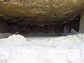
Inside view of a Talaja Cave.

References[]
| Wikimedia Commons has media related to Talaja caves. |
- ^ "Talaja, Palitana - Shatrunjaya, Rajkot, Tourism Hubs, Gujarat, India". www.gujarattourism.com. Retrieved 14 August 2020.
- ^ Archaeological Survey of India, Vadodara Circle. "Talaja Caves". Archaeological Survey of India. Archived from the original on 2 December 2013. Retrieved 1 December 2013.
- ^ Census of India, 1991: Kheda. Government Photo Litho Press. 1992.
- ^ Tourism Corporation of Gujarat Limited. "Talaja". Gujarat Tourism, Govt. of Gujarat. Retrieved 1 December 2013.
- ^ Brancaccio, Pia (2010). The caves at Aurangabad : Buddhist art in transformation. Leiden: Brill Publishers. p. 63. ISBN 978-9004185258.
Further reading[]
- Fergusson, James; Burgess, James (6 May 2013). The cave temples of India. Cambridge: Cambridge University Press. pp. 201–202. ISBN 978-1108055529.
This article about a location in Bhavnagar district, Gujarat, India is a stub. You can help Wikipedia by . |
- Buddhist caves in India
- Caves of Gujarat
- Indian rock-cut architecture
- Former populated places in India
- Buddhist pilgrimage sites in India
- Buddhist temples in India
- Caves containing pictograms in India
- Bhavnagar district
- 2nd-century Jain temples
- Jain rock-cut architecture
- Monuments of National Importance in Gujarat
- Gujarat geography stubs