Tanjung Selor
Tanjung Selor | |
|---|---|
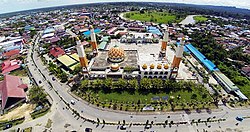 A view of Tanjung Selor | |
 Tanjung Selor Location in Kalimantan and Indonesia | |
| Coordinates: 2°51′0″N 117°23′0″E / 2.85000°N 117.38333°ECoordinates: 2°51′0″N 117°23′0″E / 2.85000°N 117.38333°E | |
| Country | |
| Province | |
| Regency | Bulungan |
| Founded | 12 October 1790 |
| Area | |
| • Total | 677.77 km2 (261.69 sq mi) |
| Elevation | 24 m (79 ft) |
| Population (mid 2019) | |
| • Total | 52,432 |
| • Density | 77/km2 (200/sq mi) |
| [1] | |
| Time zone | UTC+8 (Indonesia Central Time) |
| Area code | (+62) 553 |


The town of Tanjung Selor is the capital of both the North Kalimantan province in Indonesia, and of the Bulungan Regency. It is the only provincial capital in Indonesia that is a district (kecamatan) and which as of 2021 does not yet have city status, except for Mamuju in West Sulawesi. The district has an area of 677.77 km2 and at the 2010 Census had a population of 39,439.[2] As of mid-2019, the official population estimate is 52,432.[3]
History[]
Tanjung Selor was a small market town under the Sultanate of Bulungan, which later became the subject of the Dutch East Indies. After the Indonesian National Revolution, it became part of the Swapraja (Autonomus Royal Region) of Bulungan following Decree No. 186/ORB/ 92/14/1950 from the then-Kalimantan province governor. This later changed again into the Special Region of Bulungan under Law No. 22 of 1955. In 1959, the sultanate was abolished and became a second-level administrative region, now called a regency.[4][5][6]
Tanjung Selor was split from Tanjung Palas District, based on Bulungan Regency Law No. 13 of 2002, together with other seven new districts after the decentralization. Before the creation of the new North Kalimantan province split from East Kalimantan, it was determined to locate the provincial capital on mainland Kalimantan rather than the in the then-largest provincial city of Tarakan, which is an island. As such, Tanjung Selor is among few Indonesian provincial capitals to be created from scratch, alongside with Sofifi and Palangka Raya. However, for financial reasons a moratorium under President Joko Widodo on creating second-level administrations so far has prevented granting Tanjung Selor city status. As of 2021, North Kalimantan remains the only province with a district as its capital, except for West Sulawesi.[7][8]
Geography[]
The district is mostly a flat, low-lying region with hills whose height varies from 0 to 500 meters above sea level. Borders of The district borders Central Tanjung Palas District in the north, East Tanjung Palas District in the east and the south, and Kayan river in the west. Soil in the district is acidic, with a pH range between 4 and 6. Another river, the Selor, also runs through the district.[9][10]
Climate[]
Tanjung Selor has a tropical rainforest climate (Af) with heavy rainfall year-round.
| hideClimate data for Tanjung Selor | |||||||||||||
|---|---|---|---|---|---|---|---|---|---|---|---|---|---|
| Month | Jan | Feb | Mar | Apr | May | Jun | Jul | Aug | Sep | Oct | Nov | Dec | Year |
| Average high °C (°F) | 30.0 (86.0) |
30.0 (86.0) |
30.2 (86.4) |
30.5 (86.9) |
30.8 (87.4) |
30.5 (86.9) |
30.7 (87.3) |
30.8 (87.4) |
30.9 (87.6) |
31.0 (87.8) |
30.8 (87.4) |
30.3 (86.5) |
30.5 (87.0) |
| Daily mean °C (°F) | 26.5 (79.7) |
26.5 (79.7) |
26.7 (80.1) |
27.0 (80.6) |
27.2 (81.0) |
26.8 (80.2) |
26.9 (80.4) |
26.9 (80.4) |
27.0 (80.6) |
27.0 (80.6) |
27.1 (80.8) |
26.8 (80.2) |
26.9 (80.4) |
| Average low °C (°F) | 23.0 (73.4) |
23.0 (73.4) |
23.3 (73.9) |
23.5 (74.3) |
23.6 (74.5) |
23.2 (73.8) |
23.1 (73.6) |
23.1 (73.6) |
23.1 (73.6) |
23.1 (73.6) |
23.4 (74.1) |
23.3 (73.9) |
23.2 (73.8) |
| Average precipitation mm (inches) | 235 (9.3) |
235 (9.3) |
212 (8.3) |
186 (7.3) |
222 (8.7) |
189 (7.4) |
207 (8.1) |
213 (8.4) |
229 (9.0) |
229 (9.0) |
281 (11.1) |
278 (10.9) |
2,716 (106.8) |
| Source: [11] | |||||||||||||
Economy[]
Agricultural land use includes chilis, tomatoes, ginger, galangal, and turmeric. Chili production was 337 tons in 2019, with 295 tons of tomatoes, 57 tons of ginger, 52 tons of galangal, and four tons of turmeric. The district also includes plantation sectors which produce mangoes, citrus, durian, and bananas. There are 68 registered restaurants in the district as of 2019 and 12 convenience stores. There also are 11 hotels as of 2019. Twelve banks operate in the district, of which nine are branches of state-owned banks, two are private banks, and one, the People's Credit Bank, is a municipally-owned BPR. There also are 45 registered cooperatives.[12]
Governance[]

As a district, it is a third-level administrative region under a regency. A district head(camat) is appointed directly by the regent with recommendation from the regency secretary. Tanjung Selor itself has no parliament.[13][14] The district is divided into nine urban villages (kelurahan).
- Gunung Seriang
- Tanjung Selor Hulu
- Jelarai Selor
- Gunung Sari
- Bumi Rahayu
- Apung
- Tengkapak
- East Tanjung Selor
- Tanjung Selor Hilir
At the regency level, the district, together with East Tanjung Palas, is part of the Bulungan first electoral district, which sends 11 representatives to the regency-level parliament. The latest election was in 2019, and the next is expected in 2024.[15]
Infrastructure[]
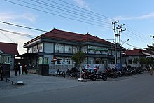
The district is served by the Tanjung Harapan Airport. All roads in the district are asphalt-paved and in good condition as of 2020, according to Statistics Indonesia. As of 2019, the district has 35 elementary schools, 19 junior high schools, 10 senior high schools, three vocational high schools, and three higher education institutions. There is also one hospital, 11 puskesmas government health clinics, three additional clinics, seven healthcare centers, and 17 pharmacies. Most of the district is reached by 4G wireless signal and basic telecommunication services.[12][16][17] The district's hospital, Dr. H. Soemarno Sosroatmojo Regional Hospital, is a public hospital owned by the regency government; built in 1984, it is classified as a C-class hospital by the Ministry of Health.[18][19]
References[]
- ^ Badan Pusat Statistik, Jakarta, 2020.
- ^ Biro Pusat Statistik, Jakarta, 2011.
- ^ Badan Pusat Statistik, Jakarta, 2020.
- ^ prokal.co. "Beri Pemahaman Sejarah Tanjung Selor | Radar Tarakan". kaltara.prokal.co (in Indonesian). Retrieved 2021-04-25.
- ^ "Sejarah Bulungan".
- ^ "JPNN". www.jpnn.com (in Indonesian). 2016-05-17. Retrieved 2021-04-25.
- ^ Media, Kompas Cyber (2019-03-31). "Tanjung Selor, Model Pengembangan Ibu Kota Baru". KOMPAS.com (in Indonesian). Retrieved 2021-04-25.
- ^ "Sejarah Kecamatan". Kecamatan Tanjung Selor. 2019-05-17. Retrieved 2021-04-25.
- ^ "Geografis". Kecamatan Tanjung Selor. 2019-05-17. Retrieved 2021-04-25.
- ^ "Kecamatan Tanjung Selor".
- ^ https://en.climate-data.org/location/52115
- ^ Jump up to: a b "Kecamatan Tanjung Selor Dalam Angka 2020".
- ^ Government Law No.19 1998
- ^ "PP No. 17 Tahun 2018 tentang Kecamatan [JDIH BPK RI]". peraturan.bpk.go.id. Retrieved 2021-04-25.
- ^ "Keputusan KPU Kaltara" (PDF).
- ^ prokal.co. "4G Hanya di Tiga Titik | Harian Rakyat Kaltara". rakyatkaltara.prokal.co (in Indonesian). Retrieved 2021-04-25.
- ^ "Wilayah Muara Bulungan Kini Terbebas dari Blank Spot". Niaga.Asia (in Indonesian). 2020-02-03. Retrieved 2021-04-25.
- ^ "Informasi SDM Kesehatan Nasional". bppsdmk.kemkes.go.id. Retrieved 2021-04-25.
- ^ "RSUD dr. H. SOEMARNO SOSROATMODJO TANJUNG SELOR". rsutanjungselor.com. Retrieved 2021-04-25.
External links[]
- Official website Bulungan Regency Official Website
| show Regencies and cities of North Kalimantan |
|---|
This North Kalimantan location article is a stub. You can help Wikipedia by . |
- Districts of North Kalimantan
- Provincial capitals in Indonesia
- Regency seats of North Kalimantan
- Bulungan Regency
- Kalimantan geography stubs