Theodore, Saskatchewan
Theodore | |
|---|---|
Village | |
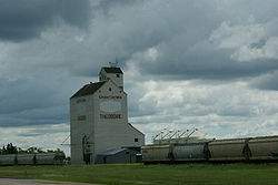 Grain elevator in Theodore | |
 Location of Theodore, in Saskatchewan | |
| Coordinates: 51°25′30″N 102°55′15″W / 51.42500°N 102.92083°WCoordinates: 51°25′30″N 102°55′15″W / 51.42500°N 102.92083°W | |
| Country | Canada |
| Province | Saskatchewan |
| Rural Municipalities (R.M.) | Insinger No. 275, Saskatchewan |
| Post office Founded | 1893-12-01 |
| Area | |
| • Total | 1.73 km2 (0.67 sq mi) |
| Population (2006) | |
| • Total | 339 |
| • Density | 1.73/km2 (4.5/sq mi) |
| • Summer (DST) | CST |
| [1][2][3][4] | |


Theodore (2016 population: 323) is a village in the Canadian province of Saskatchewan within the Rural Municipality of Insinger No. 275 and Census Division No. 9. Theodore is located on Saskatchewan Highway 16, the Yellowhead Highway, in southeastern Saskatchewan.[5] The Theodore post office first opened in 1893 at the legal land description of Sec.1, Twp.28, R.7, W2.[6] Theodore is located between Yorkton and Foam Lake.
In 1974, with the end of passenger rail service, the Theodore railway station was adopted for use as a senior citizens' centre; it serves as the home for the Theodore Historical Museum.[7]
History[]
Theodore incorporated as a village on July 5, 1907.[8]
Demographics[]
In the 2016 Census of Population conducted by Statistics Canada, the Village of Theodore recorded a population of 323 living in 167 of its 211 total private dwellings, a -6.8% change from its 2011 population of 345. With a land area of 1.73 km2 (0.67 sq mi), it had a population density of 186.7/km2 (483.6/sq mi) in 2016.[11]
In the 2011 Census of Population, the Village of Theodore recorded a population of 345, a 1.8% change from its 2006 population of 339. With a land area of 1.73 km2 (0.67 sq mi), it had a population density of 199.4/km2 (516.5/sq mi) in 2011.[12]
See also[]
| Wikimedia Commons has media related to Theodore, Saskatchewan. |
- List of communities in Saskatchewan
- List of rural municipalities in Saskatchewan
References[]
- ^ National Archives, Archivia Net, Post Offices and Postmasters
- ^ Government of Saskatchewan, MRD Home, Municipal Directory System, archived from the original on November 21, 2008
- ^ Canadian Textiles Institute. (2005), CTI Determine your provincial constituency
- ^ Commissioner of Canada Elections, Chief Electoral Officer of Canada (2005), Elections Canada On-line
- ^ Adamson, J, Rand McNally 1924 Saskatchewan Map, retrieved 2008-03-26
- ^ National Archives, Archivia Net, Post Offices and Postmasters, retrieved 2008-03-26
- ^ "Canadian Pacific Railway Station". Canada's Historic Places - a Federal Provincial and Territorial Collaboration. Retrieved 2011-03-20.
- ^ "Urban Municipality Incorporations". Saskatchewan Ministry of Government Relations. Archived from the original on October 15, 2014. Retrieved June 1, 2020.
- ^ "Saskatchewan Census Population" (PDF). Saskatchewan Bureau of Statistics. Archived from the original (PDF) on September 24, 2015. Retrieved May 31, 2020.
- ^ "Saskatchewan Census Population". Saskatchewan Bureau of Statistics. Retrieved May 31, 2020.
- ^ "Population and dwelling counts, for Canada, provinces and territories, and census subdivisions (municipalities), 2016 and 2011 censuses – 100% data (Saskatchewan)". Statistics Canada. February 8, 2017. Retrieved May 30, 2020.
- ^ "Population and dwelling counts, for Canada, provinces and territories, and census subdivisions (municipalities), 2011 and 2006 censuses (Saskatchewan)". Statistics Canada. June 3, 2019. Retrieved May 30, 2020.
 Definitions from Wiktionary
 Media from Wikimedia Commons
 News from Wikinews
 Quotations from Wikiquote
 Texts from Wikisource
 Textbooks from Wikibooks
 Resources from Wikiversity
| show Places adjacent to Theodore, Saskatchewan |
|---|
| show |
|---|
| show Division No. 9, Saskatchewan |
|---|

- Villages in Saskatchewan
- Insinger No. 275, Saskatchewan
- Division No. 9, Saskatchewan