Tigris
| Tigris | |
|---|---|
 Tigris river in Baghdad | |
 Map of the Tigris–Euphrates river system | |
| Location | |
| Country | Turkey, Syria, Iraq |
| Cities | Diyarbakır, Mosul, Baghdad |
| Physical characteristics | |
| Source | Lake Hazar[1] |
| • coordinates | 38°29′0″N 39°25′0″E / 38.48333°N 39.41667°E |
| • elevation | 1,150 m (3,770 ft) |
| Mouth | Shatt al-Arab |
• location | Al-Qurnah, Basra Governorate, Iraq |
• coordinates | 38°26′0″N 39°46′22″E / 38.43333°N 39.77278°ECoordinates: 38°26′0″N 39°46′22″E / 38.43333°N 39.77278°E |
| Length | 1,900 km (1,200 mi) |
| Basin size | 375,000 km2 (145,000 sq mi) |
| Discharge | |
| • location | Baghdad |
| • average | 1,014 m3/s (35,800 cu ft/s) |
| • minimum | 337 m3/s (11,900 cu ft/s) |
| • maximum | 2,779 m3/s (98,100 cu ft/s) |
| Basin features | |
| River system | Tigris–Euphrates river system |
| Tributaries | |
| • left | , Botan, Khabur, Greater Zab, Lesser Zab, 'Adhaim, Cizre, Diyala |
| • right | Wadi Tharthar |
| [2][3] | |

The Tigris (/ˈtaɪɡrɪs/) is the eastern of the two great rivers that define Mesopotamia, the other being the Euphrates. The river flows south from the Southeastern Anatolia Region through the Syrian and Arabian Deserts, and empties into the Persian Gulf.
Geography[]
The Tigris is 1,750 km long, rising in the Taurus Mountains of eastern Turkey about 25 km southeast of the city of Elazig and about 30 km from the headwaters of the Euphrates. The river then flows for 400 km through Southeastern Turkey before becoming part of the Syria-Turkey border. This stretch of 44 km is the only part of the river that is located in Syria.[2] Some of its affluences are Garzan, Anbarçayi, Batman, and the Great and the Little Zab.[4]
Close to its confluence with the Euphrates, the Tigris splits into several channels. First, the artificial Shatt al-Hayy branches off, to join the Euphrates near Nasiriyah. Second, the Shatt al-Muminah and Majar al-Kabir branch off to feed the Central Marshes. Further downstream, two other distributary channels branch off (the and ), to feed the Hawizeh Marshes. The main channel continues southwards and is joined by the , which drains the Hawizeh Marshes. Finally, the Tigris joins the Euphrates near al-Qurnah to form the Shatt-al-Arab. According to Pliny and other ancient historians, the Euphrates originally had its outlet into the sea separate from that of the Tigris.[5]
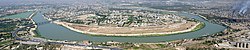
Baghdad, the capital of Iraq, stands on the banks of the Tigris. The port city of Basra straddles the Shatt al-Arab. In ancient times, many of the great cities of Mesopotamia stood on or near the Tigris, drawing water from it to irrigate the civilization of the Sumerians. Notable Tigris-side cities included Nineveh, Ctesiphon, and Seleucia, while the city of Lagash was irrigated by the Tigris via a canal dug around 2900 B.C.
[]
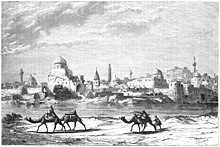
The Tigris has long been an important transport route in a largely desert country. Shallow-draft vessels can go as far as Baghdad, but rafts are needed for transport upstream to Mosul.
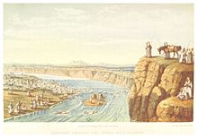
General Francis Rawdon Chesney hauled two steamers overland through Syria in 1836 to explore the possibility of an overland and river route to India. One steamer, the Tigris, was wrecked in a storm which sank and killed twenty. Chesney proved the river navigable to powered craft. In 1855, a convoy of rafts carrying antiquities from Victor Place's expedition to Khorsabad, Rawlinson's to Kuyunjik and Fresnel's to Babylon was sunk by local tribes near Al-Qurnah.[6][7] Later, the Euphrates and Tigris Steam Navigation Company was established in 1861 by the Lynch Brothers trading company, who had two steamers in service. By 1908 ten steamers were on the river. Tourists boarded steam yachts to venture inland as this was the first age of archaeological tourism, and the sites of Ur and Ctesiphon became popular with European travellers.
In the First World War, during the British conquest of Ottoman Mesopotamia, Indian and Thames River paddlers were used to supply General Charles Townsend's army, in the Siege of Kut and the Fall of Baghdad (1917).[8] The Tigris Flotilla included vessels Clio, Espiegle, Lawrence, Odin, armed tug Comet, armed launches Lewis Pelly, Miner, Shaitan, Sumana, and sternwheelers Muzaffari/Muzaffar. These were joined by Royal Navy Fly-class gunboats Butterfly, Cranefly, Dragonfly, Mayfly, Sawfly, Snakefly, and Mantis, Moth, and Tarantula.
After the war, river trade declined in importance during the 20th century as the Basra-Baghdad-Mosul railway, a previously unfinished portion of the Baghdad Railway, was completed and roads took over much of the freight traffic.
Etymology[]
The Ancient Greek form Tigris (Τίγρις) meaning "tiger" (if treated as Greek) was adapted from Old Persian Tigrā, itself from Elamite Tigra, itself from Sumerian Idigna.
The original Sumerian Idigna or Idigina was probably from *id (i)gina "running water",[9] which can be interpreted as "the swift river", contrasted to its neighbour, the Euphrates, whose leisurely pace caused it to deposit more silt and build up a higher bed than the Tigris. The Sumerian form was borrowed into Akkadian as Idiqlat, and from there into the other Semitic languages (cf. Hebrew Ḥîddeqel, Syriac Deqlaṯ, Arabic Dijlah).
Another name for the Tigris used in Middle Persian was Arvand Rud, literally "swift river". Today, however, Arvand Rud (New Persian: اروند رود) refers to the confluence of the Euphrates and Tigris rivers (known in Arabic as the Shatt al-Arab). In Kurdish, it is also known as Ava Mezin, "the Great Water".


The name of the Tigris in languages that have been important in the region:
| Language | Name for Tigris |
|---|---|
| Akkadian |
|