This article needs additional citations for verification. Please help by adding citations to reliable sources. Unsourced material may be challenged and removed. Find sources: – ···scholar·JSTOR(December 2009) (Learn how and when to remove this template message)
Tiradentes is a municipality in the Brazilian state of Minas Gerais. It is located at
WikiMiniAtlas
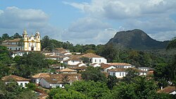
21°06′37″S44°12′41″W / 21.11028°S 44.21139°W / -21.11028; -44.21139, has an area of 83.5 km², and a maximum elevation above sea level of 927 m. Tiradentes had an estimated population of 10,960, as of 2020. The original village was established in 1702 and became a city on 19 January 1718. In 1889 the city was renamed from Vila de São José do Rio das Mortes in honour of the national hero who was born nearby.
It has been acclaimed as an unspoiled example of Portuguese colonial architecture.
Other historical cities in Minas Gerais are Ouro Preto, São João del-Rei, Diamantina, Mariana, Congonhas and Sabará.
See also[]
A section of the Estrada de Ferro Oeste de Minas narrow gauge railway from São João del-Rei to Tiradentes has been preserved as a tourist line.


 21°06′31″S 44°10′28″W / 21.10861°S 44.17444°W / -21.10861; -44.17444Coordinates: