Toronto ravine system
| Toronto ravine system | |
|---|---|
 Little Rouge Creek and the Rouge Valley, one of the ravines in the system | |
| Location | Toronto, Ontario, Canada |
| Area | 110 square kilometres (42 sq mi)[1][note 1] |
| Formed by | Erosion, receding glaciers |
| Website | www |
The Toronto ravine system is a distinctive feature of the city's geography, consisting of a network of deep ravines which forms a large urban forest that runs through most of Toronto. The ravine system is the largest in any city in the world, with the Ravine and Natural Feature Protection Bylaw protecting approximately 110 square kilometres (42 sq mi) of public and privately-owned land. The ravine system has been presented as a central characteristic of the city, with the size of the ravine system leading Toronto to be described as "a city within a park".
The ravine system began to take shape approximately 12,000 years ago; when the glaciers that once covered Toronto retreated northeast, leaving rivers and valleys in its place. Due to the topography of the ravine system, limited urban development occurred within it until the mid-19th century. During the late-19th and early 20th centuries, the ravine system underwent a number of changes and saw several infrastructure developments built within it. Limited development in the ravine system continued until Hurricane Hazel passed through Toronto in 1954; when the destruction caused by the hurricane resulted in the cessation of almost all major developments in the ravine system. The Toronto ravine system remains largely undeveloped, with most of its public lands having been designated as parkland.
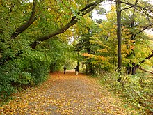
More than two-thirds of the publicly-owned portions of the ravine system is made up of forests, with the other portions being beaches, meadows, open water, successional lands, and wetlands. Although large portions of the ravine system remain undeveloped, parts of the ravine system is used for flood management, carbon sequestration, and recreational purposes by the city. In addition to its human uses, the ravine system also serves as a habitat and wildlife corridor for a large number of animals.
Origin[]
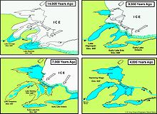
The Toronto ravine system originated approximately 12,000 years ago at the end of the Last Glacial Period, with rivers and valleys being formed in the wake of the retreating glaciers and the compressed land it left.[2][3][4][5] Meltwater from glacial deposit at the Oak Ridges Moraine, situated 30 kilometres (19 mi) north of the city, flowed southeast towards Glacial Lake Iroquois;[4] carving through nearly 100 metres (330 ft) of soil, alluvial soft sand, gravel, and clay till to form the ravine valleys.[4][6] Most of the meltwater flowed southeast along shallow ice-scrapped depressions towards the glacial lake, creating small ponds north of Toronto.[7] However, the early Don and Humber rivers are notable exceptions, with these waterways flowing along the compacted channels of the former Laurentian River System, an ancient river system that was scoured and buried during the Last Glacial Period.[7]
After the glacial ice had retreated north of the St. Lawrence Valley approximately 9,000 years ago, the water level of glacial Lake Iroquois began to recede.[8] The drop in water levels saw new waterways formed as the water meandered through the former lakebed into the newly formed Lake Admiralty; with the two main branches of the Don River joined at the old shoreline of Lake Iroquois, and new streams having been formed.[8] The new lake existed until approximately 8,000 years ago, when the earth's crust around Quebec and northeastern Ontario began to rebound, having been previously depressed under the weight of the glacial ice that had since retreated from that area.[9] Water levels in the lake gradually rose as the earth's crust near the lake's outlet to the Saint Lawrence River rebounded.[8] Major plateaus in the system, such as the lower Don Valley, were formed during this period; as rising water levels from Lake Ontario pushed into the lower valley, and sediment washed down from the upper valley accumulated in the lower waterbed.[8] The flooding of the lower ravine system also resulted in the formation of several spits, lagoons, and wetlands near Toronto's shoreline.[9]

Prior to the arrival of European settlers, the landscape from Lake Ontario to the Oak Ridge Moraine was dominated by forests of maple, beech, and hemlock trees; while its low-lying areas was made up of forests and shrub swamps, with extensive marches along the Toronto shoreline.[8][10] A large number of the trees surrounding the Town of York were logged in the early 19th century, including a number of trees in the ravine system.[10][11] However, portions of the ravine system saw limited human developments, with flood-prone areas of the ravine having prevented large-scale urban developments.[12] As a result, the ravine system holds the largest collection of trees in the city that predate European colonization.[10]
The ravine system also saw significant alterations as a result of human activity in the 19th and early 20th century; as several natural valleys were filled in, rivers rechannelled or buried entirely, and wetlands drained in order to facilitate new developments.[2][11] The Don River was altered near the mouth of the river, with a concrete channel created to prevent the Port Lands from flooding.[11] Creeks and ravines within downtown Toronto were also buried during this period, including Garrison and Taddle Creek.[11] As a result of these changes, the Don River, and a small portion of Taddle Creek were the only remaining waterways that flowed into Toronto Bay by the mid-20th century.[13] The surviving portions of Toronto's ravine system primarily surrounds four waterways, the Don River, Highland Creek, Humber River, and the Rouge River;[11] although smaller ravines can also be found along the other waterways of Toronto, including Etobicoke Creek and Mimico Creek.[5]
Locations[]

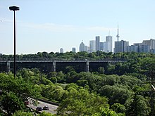
The ravine system is situated on the north shore of Lake Ontario, straddling the Carolinian forest and the Great Lakes–St. Lawrence Lowlands.[14] The landscape of the ravine system includes large river valleys, and smaller creeks.[15] Many of the larger waterways are surrounded by narrow steep-sided valleys, with the waterways having eroded the soft deposits around it to reveal large exposures of Ordovician rocks; many of these rocks visible along the stream banks.[16][17] The ravine system forms a part of a larger network of ravines that extends towards the Oak Ridges Moraine, located north of Toronto.[3] The largest ravines surround the rivers running south from the moraine towards Lake Ontario, the Don, Humber, and Rouge rivers.[18]
The present ravine system is a protected natural land forms under the Ravine and Natural Feature Protection Bylaw. The bylaw defines a ravine is a distinct land form with a minimum of 2 metres (6.6 ft) change in grade between "the highest and lowest points of elevation," has vegetation cover, and has or once had water flowing through or adjacent to the land form.[1] In addition to these landforms, buffer areas and some other environmentally significant areas are also covered under this act.[1] In total, the act protects approximately 17 per cent of the land in the city, or about 11,000 hectares (27,000 acres) of land.[1] The system contains at least 150 ravines;[19] constituting the largest ravine system in any city in the world.[20][21][22] The edge of the ravine system throughout the city collectively amounts to over 1,200 kilometres (750 mi), ten times the length of the Toronto waterfront. The system is primarily surrounded by residential areas.[3]

Approximately 60 per cent of the protected land is publicly-owned, whereas the remaining 40 per cent is held privately.[1] Within this area there are 86 municipally-recognized "Environmentally Significant Areas" and 1,500 urban parks.[23] Most of the ravine system remains in a naturalized state for flood control purposes, given the high variability in the water levels of the rivers and streams.[24] During the late summer, many of the smaller streams will slow to a trickle or even disappear completely. During the spring and after major storms, creeks in the ravine will often overflow their banks.[24] More than two-thirds of the publicly-owned portions of the ravine system are forests, with its remaining portions being beaches, meadows, open water, successional lands, and wetlands.[25] The ravine system accounts for approximately 36 per cent of the city's total tree cover.[25]
Nearly the entire ravine system forms a part of the city's green space and natural heritage system, with municipal bylaws for those areas largely restricting human developments, with exceptions for compatible recreational and cultural facilities and essential public works.[26] Legal ordinances that restrict developments within the ravine system includes the Ravine and Natural Feature Protection Bylaw, which restricts the destruction of any tree in the system without a permit from the city; and TRCA Regulation 166/06, which prohibits any man-made alterations or filling of the ravine system's waterways or wetlands without a permit from the Toronto and Region Conservation Authority (TRCA).[26]
Waterways[]
The Toronto ravine system forms a part of a larger regional watershed system that encompasses the Golden Horseshoe Greenbelt and the Oak Ridges Moraine.[23] The ravine system contains seven watersheds, the Don River, Etobicoke Creek, Highland Creek, Humber River, Mimico Creek, Petticoat Creek, and the Rouge River.[13] The Humber watershed is the largest of the seven watersheds, although the Don watershed constitutes the largest percentage of the city's land area, making up 32.5 per cent of the city.[13] In total, there is approximately 371 kilometres (231 mi) of watercourses that flow through the city and its ravine.[13]

Most of the smaller creeks and streams are situated within the city limits of Toronto, although the source for the larger three rivers of the ravine system, the Don, Humber, and Rouge, originates from the Oak Ridges Moraine, a moraine located north of the city.[1] The point where the Humber, Don, and Rouge River watersheds meet is near the intersection of Bathurst Street and Jefferson Sideroad at the Vaughan-Richmond Hill boundary.[27]
Many of the ravines that surround these waterways branch off into smaller ravines, winding through commercial, industrial, and residential neighbourhoods of the city.[5] The shape of streams within the ravine system are subject to constant change, with large storms causing the area to flood, and erosion to occur on river banks and meanders.[28] In particular, waterways in narrow ravines, and straightened/rechannelled waterways are particularly susceptible to change due to erosion.[28]
As a result of heavy urbanization around Black Creek, the water quality of the creek is considerably lower in comparison to the other watersheds of the ravine system.[29]
Fauna and flora[]

The ravine system holds the greatest variety of ecosystems, species and genetic diversity within the city.[30] The variety in species is a result of the mosaic of ecosystems that exists within the system, including forests, wetlands, rivers and streams.[30] The connected nature of these habitats helps supports the extensive biodiversity within ravines.[30] The ravine system serves as a habitat for approximately 1,700 species of animals and plants;[5] including a number of locally, regionally, and provincially sensitive species and species at risk.[31] Approximately 90 per cent of animals that reside in Toronto inhabit the ravine system.[32] In addition to providing a habitat in an urban environment, the ravine system also acts as a wildlife corridor, permitting the animals that live within it to travel from one area of the city to another.[33] The corridors are of particular importance for wild mammals, as they provide the only safe passage for them to traverse from one part of the city to another to find new mates and establish their own homes.[33]
The ravine system is one of the northernmost Carolinian forests found in North America, consisting of mixed woodlands and southern traces of the boreal forest.[6] Around 1,000 plant species may be found in the ravine system, making up approximately 25 per cent of all plant species that can be found in Ontario.[6] Most flora that is native to the area, such as the oak, have the genetic diversity that makes them more adaptable and resilient to extreme climate events and pest infestations.[30] Poison ivy and nettles are also abundant.[34] However, a decline in the quality of vegetation composition had been observed between 2009 and 2019; with invasive plant species spreading throughout the ravine system.[31] At least one of 15 identified high-risk invasive plant species was found in 75 per cent of areas surveyed.[31] Norway Maples are an invasive tree species that is found in the ravine system and out-competing native vegetation.[35] A study of the ravine system's ecology in 2018 indicated that the native flora in the ravine system faced extirpation if action wasn't taken against the invasive flora; with certain invasive species such as the Norway maple having seized large portions of the ravine system by killing off native undergrowth and saplings.[22]
Human history[]
A number of artifacts dating to the Archaic period in North America have been found in the ravine system.[36] After the introduction of corn in southern Ontario circa 500 CE, the ancestral Wyandot peoples began to raise the crop by clearing the floodplains.[37] By the 14th century, the area held a number of Wyandot and Petun communities around the Don, Humber, and Rouge drainage system.[38] The large amount of timber needed to house these communities were typically extracted from nearby cedar swamps.[38] However by the end of the 16th century, most of these communities had moved northward to other Petun and Huron communities around present-day Simcoe County.[39]
The areas was later occupied by the Seneca in the 1600s, with early European explorers having noted the existence of a Seneca village on the Humber, and another on the Rouge rivers in the 1660s.[40][39]
The first Europeans to arrive in the area were primarily explorers, fur traders, and missionaries; with a French Sulpician mission established at the mouth of the Rouge River by 1669.[6] From the 17th century to 19th century, the ravine system formed a part of the Toronto Carrying-Place Trail, a major canoe-and-portage route used by fur traders to reach the upper Great Lakes.[2][41]

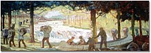
The first sawmill opened in Toronto was at the Don River valley in 1795.[42] During the late-18th and 19th century, portions of the ravine system was logged for building materials, leaving few trees in Toronto that date to before the end of logging around 1850.[43] From the late 18th to 20th century, clay was also extracted from the ravine system, with the first brickworks opened in the ravine system in 1796.[7] The Don Valley Brick Works was major brickworks that served as a major quarry and source of building material for the city until 1984.[11][20] Clay excavations at the Don Valley Brick Works have provided researchers with the best known preserved interglacial record in northern North America.[44]
Urban developments within the ravines were largely limited in the early-19th century, as the muddy glacial sediment that made up the ravine valley acted as a major obstacle for construction.[16] However, the cleared portions of the ravine system saw several dump sites, farms, mills, and landscaped parks established in the 19th and 20th centuries.[2] By the mid-19th century, the Don Valley gained a reputation as a "space for undesirables," with residents of the city perceiving the ravine as an area that harboured and facilitated lawlessness.[45] The perception of the ravine system during the mid-19th century led developers to build low-end neighbourhoods near the ravine system; an area situated on the periphery of 19th century Toronto and near its industrial lands.[46]
During the late 19th century, a number of wetlands and lagoons at the mouths of the Don River were infilled, as the shallowness of Ashbride's Marsh made the area optimal for redevelopment as the Port Lands.[44] The Don River around the river's mouth was also straightened, in an effort to attract shipping upriver.[47] Some smaller waterways in Toronto were also buried during this period, after public health officials prompted the municipal government to cover the smaller waterways being used by residents as a receptacle for trash and human waste.[48] The city's sewage system and water filtration plant was also built into the ravine system during the late-19th century.[2] Many of Toronto's storm drains continue to empty into the ravines, with large parts of the city's infrastructure still reliant on the ravine system to absorb and filter storm water in case of overflow.[32][49]

By the mid-1950s, several plans had emerged to create public parks within the ravine system, and protect the system from further human development.[50] Developments in the ravine system were largely halted after Hurricane Hazel passed through Toronto in 1954; with the hurricane destroying a number of homes and leaving 1,868 families homeless.[28] A number of the homes that were destroyed were situated in the rechannelled rivers and streams of the ravine system, areas already threatened by flooding from heavy rainfalls.[28] The TRCA was formed under the provincial Conservation Authorities Act as a result of the disaster.[28] The TRCA established several flood control and water management policies that saw major developments halted within the ravine system.[28] As a result, most of the ravine system that remained from the 1950s was preserved, with the construction of the Don Valley Parkway being the only major exception.[42][51]
The municipal government proceeded with its plan to create several parks in the ravine system, although they were built further upstream; adjacent to the TRCA's designated reservoirs and watersheds.[50] Efforts to restore the ravine system to its natural state were launched in the 1990s, with citizen task forces such as the Task Force to Bring Back the Don formed to help facilitate tree planting and wetland creation projects.[2]
21st century[]
In 2002, the municipal government of Toronto enacted a bylaw to formally protect the ravine system from human development.[52]
The ravines were also home to a considerable number of homeless people, some of them living in fairly elaborate temporary structures. In 2001, The Globe and Mail ran a three part series titled "The Outsiders"[53] tracing the life of the homeless residents of the ravines over the course of nearly a year. It won a National Newspaper Award for best feature writing.[54] During the 2000s, illegal dumping of garbage in the ravines became an issue for forestry officials in the city.[55]
A report published in 2018 estimated that the ravine system provided the city with C$822 million in eco-system services in 2017.[56] Eco-services provided by the ravine includes aesthetics, carbon sequestration, flood mitigation, the regulation of temperature and noise, and recreation.[57] In the report, it was estimated that the ravine system is responsible for the sequestration of 14,542 tonnes of carbon per year.[57]
Work on new bypass tunnels to capture combined sewer overflows and prevent their flow into the Don River and Lake Ontario were undertaken beginning in December 2019.[58][59] The bypass tunnels will divert overflows to Ashbridges Bay Wastewater Treatment Plant for ultraviolet disinfection.[58][59]
Recreational use[]

The municipal government's official ravine strategy identifies the ravine system as areas that should be preserved in their natural state.[60] As a result, recreational activities within the ravine system have been limited to passive recreational activities, including cycling, hiking, and cross-country skiing within the ravine's parks and trails.[60][32] There exist approximately 1,500 urban parks within the ravine system.[23] However, access to some ravine parks remains limited to pedestrian traffic, most notably ravine parks where its boundary with the sidewalk and roadways has a slope greater than 45 per cent.[60][52]
In addition to small local parks, larger urban parks that encompass large portions of the ravine system have also been established during the 2010s. In 2011, the federal government announced its intention to create a national park around the Rouge River watershed.[61] In order to establish the national park, land was transferred from the municipal governments of Toronto and the surrounding municipalities to Parks Canada; with Rouge National Urban Park formally established on 15 May 2015.[61] As of July 2019, the park has incorporated 95 per cent of the 79.1 square kilometres (30.5 sq mi) of land committed to it by the municipal, provincial, and federal governments.[61] The Don River Valley Park is another large park in the ravine system opened by the municipal government.[32] The Don River Valley Park encompasses over 200 hectares (490 acres) of the lower Don River valley from Pottery Road to Corktown Common.[62] The creation of the Don River Valley Park formed a part of the larger Lower Don Master Plan, a plan to naturally restore the area.[42][32]
In 2017, the city introduced new trail signage to provide information for the surrounding area; initially on the trails of the lower Don River.[63] There were 924,486 hikers and 398,240 cyclists who used the trails in the Toronto ravine system in 2017.[64] The heavy use of some trails remains an issue for conservation efforts, with these trails showing signs of accelerated erosion and disruption to wildlife.[65]
Certain parts of the ravines are also known as gay cruising areas.[66]
In culture[]
Toronto's ravines have been presented as central to Toronto's "city within a park" character.[22] Architect Larry Richards describes Toronto as topographically being "San Francisco turned upside down" in reference to San Francisco's hilly terrain.[67] Sandy M. Smith, a professor of urban forestry at the University of Toronto, has also remarked how the ravine system acts as the "green veins of the city," defining the city landscape and shaping Toronto's road network; with roadways having to conform to the ravine's boundaries.[5] Anne Michaels' also describes Toronto as a "city of ravines," in her novel Fugitive Pieces; describing the ravine system as a place where one could "traverse the city beneath the streets, look up to the floating neighbourhoods, houses built in the treetops".[3] In several literary works, such as Margaret Atwood's Lady Oracle, the ravine system is often depicted as a meeting place where the unruly dense wilderness collided with the tidy streets of suburban Toronto.[68] The unique topography of Toronto was one of the primary reasons Atom Egoyan chose to set his film Chloe in the city.[69]

The importance of the ravine system to the city's character has influenced the works of a number Toronto-based artists and authors. Robert Fulford remarked that the "ravines are the chief characteristic of the local terrain, its topographical signature. They are both a tangible (though often hidden) part of our surroundings and a persistent force in our civic imagination. They are the shared subconscious of the municipality, the place where much of our literature is born."[70] Fulford further comments how the ravine system was typically a Torontonian's first glimpse of wilderness, representing for many residents a "savage foreign place," and a "republic of childhood"; as parents warn younger children of the "evils" that lurks within, while adolescents viewed the ravines as the only place where they can "find freedom from the vigilant gaze of adults".[71] It has been suggested by Fulford that the childhood experiences Toronto-based authors had with ravines resulted in them being used as "receptacles of the childhood experiences that they have repressed," and as a "creative, liminal space in which the ambiguities of life can play out".[72]
Other artists and authors that have highlighted the Toronto ravine system in their works include Morley Callaghan, Douglas Anthony Cooper, Ernest Hemingway, Doris McCarthy, and Michael Ondaatje.[70][73]
See also[]
Notes[]
- ^ The following figure is the area protected under the Ravine and Natural Feature Protection Bylaw
References[]
- ^ a b c d e f RavineStrat 2017, p. 6.
- ^ a b c d e f RavineStrat 2017, p. 8.
- ^ a b c d Layton & Westfall 2007, p. 228.
- ^ a b c Bonnell 2014, p. 4.
- ^ a b c d e Vincent, Donovan (7 August 2016). "Why our ravines are the city below Toronto". Toronto Star. Torstar Corporation. Retrieved 7 January 2021.
- ^ a b c d Finkelstein, Maxwell W. (25 July 2018). "Rouge National Urban Park". The Canadian Encyclopedia. Hisorica Canada. Retrieved 14 January 2021.
- ^ a b c Freeman 2008, p. 32.
- ^ a b c d e Bonnell 2014, p. 6.
- ^ a b Eyles 2008, p. 38.
- ^ a b c CoTBioD 2019, p. 17.
- ^ a b c d e f Layton & Westfall 2007, p. 229.
- ^ "Habitats in Toronto" (PDF). Birds of Toronto: A Guide to Their Remarkable World. City of Toronto. 2018. p. 13.
- ^ a b c d Hardwicke & Reeves 2008, p. 55.
- ^ CoTBioD 2019, p. 16.
- ^ RavineStrat 2017, p. 7.
- ^ a b Eyles 2008, p. 34.
- ^ Freeman 2008, p. 27.
- ^ Cundiff, Brad (1994). The Hike Ontario Guide to Walks Around Toronto. Boston Mills Press. ISBN 9781550461008.
- ^ Sumi, Glenn (7 December 2020). "Toronto ravines and forest expert talks the walks". NOW Magazine. NOW Central Communications. Retrieved 25 January 2021.
- ^ a b Wei, Jessica (5 October 2017). "Toronto's Ravines: This Underground Forest Playground Has Been Transformed Into the Greatest Urban Park Ever". The Independent. Independent Digital News & Media. Retrieved 7 January 2021.
- ^ D'Aliesio, Renata (1 April 2011). "Ravines a defining aspect of Toronto". The Globe and Mail. The Woodbridge Company. Retrieved 7 January 2021.
- ^ a b c Gecco, Leyland (21 December 2018). "There's no major city like it': Toronto's unique ravine system under threat". The Guardian. Guardian Media Group. Retrieved 7 January 2020.
- ^ a b c RavineStrat 2017, p. 25.
- ^ a b Seymour 2000, p. 13.
- ^ a b Green Analytics 2018, p. 11.
- ^ a b RavineStrat 2017, p. 12.
- ^ "Watershed Management". trca.ca. Toronto and Region Conservation Authority. 2020. Retrieved 11 December 2020.
- ^ a b c d e f RavineStrat 2017, p. 10.
- ^ Vincent, Donovan (15 October 2016). "The ugliest side of Toronto's ravines". Toronto Star. Torstar Corporation. Retrieved 25 January 2021.
- ^ a b c d CoTBioD 2019, p. 10.
- ^ a b c CoTBioD 2019, p. 26.
- ^ a b c d e "Loop Trail: Connecting and Protecting Toronto's Ravines". www.evergreen.ca. Evergreen. 29 January 2020. Retrieved 14 January 2021.
- ^ a b "Mammals of Toronto" (PDF). City of Toronto. 2012. p. 11. Retrieved 7 January 2021.
- ^ Seymour 2000, p. 9.
- ^ CoTBioD 2019, p. 30.
- ^ Allemang, John (7 August 2015). "Toronto's ravine system offers the perfect escape from urban life". The Globe and Mail. The Woodbridge Company. Retrieved 7 January 2021.
- ^ Eyles 2008, p. 46–47.
- ^ a b MacDonald & Williamson 2008, p. 47.
- ^ a b MacDonald & Williamson 2008, p. 49.
- ^ Bonnell 2014, p. 10.
- ^ MacDonald & Williamson 2008, p. 50.
- ^ a b c "History". donrivervalleypark.ca. Evergreen. 2021. Retrieved 14 January 2020.
- ^ Seymour 2000, p. 139.
- ^ a b Eyles 2008, p. 41.
- ^ Bonnell 2014, p. 87.
- ^ Bonnell 2014, p. 76–77.
- ^ Hardwicke & Reeves 2008, p. 62.
- ^ Kwan, Amanda (19 July 2013). "How to keep Toronto's storm sewers from flooding? Bring the rivers back". The Globe and Mail. The Woodbridge Company. Retrieved 16 January 2021.
- ^ Seymour 2000, p. 60.
- ^ a b White 2016, p. 126.
- ^ Bonnell 2014, p. 139.
- ^ a b Layton & Westfall 2007, p. 230.
- ^ Philp, Margaret (2003). "The Outsiders". The Globe and Mail. Bell Globemedia Interactive. Archived from the original on 13 January 2005. Retrieved 23 March 2007.
- ^ "National Newspaper Awards". The Globe and Mail. Bell Globemedia Interactive. 2003. Archived from the original on 16 May 2007. Retrieved 18 March 2007.
- ^ Lakey, Jack (15 June 2005). "One year later, we still have trouble with trash". Toronto Star. Torstar Corporation. p. B.01.
- ^ CoTBioD 2019, p. 11–12.
- ^ a b Green Analytics 2018, p. 10.
- ^ a b Brown, Desmond (14 December 2019). "Toronto launches $3B project to improve water quality in Lake Ontario and city's waterways". CBC News. Canadian Broadcasting Corporation. Retrieved 16 January 2021.
- ^ a b "Don River and Central Waterfront & Connected Projects". www.toronto.ca. City of Toronto. 2021. Retrieved 16 January 2021.
- ^ a b c "Parkland Strategy: Growing Toronto Parkland" (PDF). www.toronto.ca. City of Toronto. November 2019. Retrieved 14 January 2021.
- ^ a b c "It takes a community to create a national urban park". www.pc.gc.ca. Parks Canada. 28 October 2019. Retrieved 14 January 2021.
- ^ "About the Park". donrivervalleypark.ca. Evergreen. 2021. Retrieved 14 January 2021.
- ^ RavineStrat 2017, p. 30.
- ^ Green Analytics 2018, p. 4.
- ^ Seymour 2000, p. 142.
- ^ Hume, Christopher (22 June 1995). "Toronto greenbelts, in black and white". Toronto Star. p. G.6.
- ^ Fulford, Robert (12 June 1996). "The Invention of Toronto: A city defined by its artists". robertfulford.com. Retrieved 18 March 2007.
- ^ Cowdy 2011, p. 83–84.
- ^ Murphy, Mekado (25 March 2010). "Toronto Plays Itself". The New York Times. Retrieved 26 March 2010.
- ^ a b Ramsay-Brown, James (2020). Toronto's Ravines and Urban Forests: Their natural heritage and local history. James Lorimer & Company. p. 11–12. ISBN 9781459415263.
- ^ Cowdy 2011, p. 70.
- ^ Cowdy 2011, p. 71.
- ^ Layton & Westfall 2007, p. 234.
Further reading[]
- Green Analytics (25 July 2018). "Ecosystem Service Values of the City of Toronto Ravine System". pub-trca.escribemeetings.com. Retrieved 11 January 2021.
- "Toronto Ravine Strategy" (PDF). www.toronto.ca. City of Toronto. 2017.
- "Wild, Connected and Diverse: A Biodiversity Strategy for Toronto" (PDF). www.toronto.ca. City of Toronto. September 2019.
- Bonnell, Jennifer L. (2014). Reclaiming the Don: An Environmental History of Toronto's Don River Valley. University of Toronto Press. ISBN 9781442612259.
- Cowdy, Cheryl (2011). "Ravines and the Conscious Electrified Life of Houses: Margaret Atwood's Suburban Künstlerromane". Studies in Canadian Literature. 36 (1): 69–85.
- Eyles, Nick (2008). Reeves, Wayne; Palassio, Christina (eds.). Ravines, lagoons, cliffs and spits: The ups and downs of Lake Ontario. HTO: Toronto's Water from Lake Iroquois to Lost Rivers to Low-flow Toilets. Coach House Books. p. 34–41. ISBN 9781552452080.
- Freeman, Ed (2008). Reeves, Wayne; Palassio, Christina (eds.). Formed and shaped by water: Toronto's early landscape. HTO: Toronto's Water from Lake Iroquois to Lost Rivers to Low-flow Toilets. Coach House Books. p. 26–33. ISBN 9781552452080.
- Hardwicke, Chris; Reeves, Wayne (2008). Reeves, Wayne; Palassio, Christina (eds.). Shapeshifters: Toronto's changing watershed, streams and shorelines. HTO: Toronto's Water from Lake Iroquois to Lost Rivers to Low-flow Toilets. Coach House Books. p. 52–62. ISBN 9781552452080.
- Layton, Michael; Westfall, Bram (2007). Wilcox, Alana; Dovercourt, Jonny; Palassio, Christina (eds.). Ravine City. GreenTOpia: Reimagining Green in Toronto. Coach House Books. p. 228–235. ISBN 9781770560857.
- MacDonald, Robert I.; Williamson, Ronald F. (2008). Reeves, Wayne; Palassio, Christina (eds.). A resource like no other: Understanding the 11,000-year relationship between people and water. HTO: Toronto's Water from Lake Iroquois to Lost Rivers to Low-flow Toilets. Coach House Books. p. 42–51. ISBN 9781552452080.
- Seymour, Murray (2000). Toronto's Ravines: Walking the Hidden Country. Boston Mills Press. ISBN 9781550463224.
- White, Richard (2016). Planning Toronto: The Planners, The Plans, Their Legacies, 1940-80. UBC Press. ISBN 9780774829380.
External links[]
| Features |
| ||||||
|---|---|---|---|---|---|---|---|
| History |
| ||||||
| Geography |
| ||||||
| Economy |
| ||||||
| Politics |
| ||||||
| Public services |
| ||||||
| Education |
| ||||||
| Culture |
| ||||||
| Transportation |
| ||||||
| |||||||
- Landforms of Toronto
- Ravines of Canada