Toronto streetcar system loops

Turning loops of the Toronto streetcar system serve as termini and turnback points for streetcar routes in Toronto, Ontario, Canada. The single-ended streetcars require track loops in order to reverse direction. Besides short off-street track loops these can also be larger interchange points, having shelters and driver facilities, or be part of a subway station structure for convenient passenger interchange.
Some loops include separate unloading and loading stops, some have a single stop, and some off-street loops have no stops and passengers are not allowed to ride around the loop. If streetcars loop clockwise, the track entering the loop must cross over the track exiting, and any loading or unloading platforms must be inside the loop; if anticlockwise, any platforms must be on the outside.
Almost all loops on the system have a minimum radius of curvature of less than 15 metres (49.2 ft).[1] The tightest curves are of 11.3 metres (37.1 ft) at Roncesvalles Carhouse and Russell Carhouse.[2] The streetcars themselves are designed for a minimum radius of 10.973 metres (36 ft).[3]
Current loops[]
Loops have various shapes according to the space available. For example, the "loop" track may actually be mostly straight, using on-street trackage to complete the looping motion (as at Bingham Loop, Dufferin Gate Loop, or Oakwood Loop), or there may be a single sharp curve through almost three-quarters of a circle (as at Union Station Loop or Wolseley Loop).[4]
Some loops consist only of a single track and are blocked when occupied by a stopped streetcar. Others have a side track or dead-end "tail track" where a streetcar can wait, or a track that allows a streetcar on the loop to make a complete circle (or equivalent) and reenter the loop.
Loops at subway stations[]
Bathurst station loop[]
- Anticlockwise loop, northern terminus of the 511 Bathurst route, on the east side of Bathurst St. north of Bloor St. The tracks continue north of the station to connect to the Hillcrest Complex and St. Clair Ave. Streetcars can enter or leave the station from/onto Bathurst either northbound or southbound. The minimum radius of curvature for this loop is 12.8 m (42 ft).[2]
Broadview station loop[]
- Anticlockwise loop, eastern terminus of the 504B King and 505 Dundas routes, on the east side of Broadview Ave. north of Danforth Ave. The loop track splits into two, one for each route. All streetcars enter the station from Broadview northbound, and exit onto Erindale Ave. westbound, leading to Broadview southbound.
Dundas West station loop[]
- Clockwise loop, western terminus of the 504A King and 505 Dundas routes, on the west (nominally south) side of Dundas St. north of Bloor St. The loop track splits into two, one for each route. All streetcars enter the station from Dundas northbound (nominally westbound), and exit onto Edna Ave. eastbound, leading to Dundas southbound. The minimum radius of curvature for this loop is 12.2 m (40 ft).[2]
Main Street station loop[]
- Clockwise loop, eastern terminus of the 506 Carlton route, on the east side of Main St. north of Danforth Ave. All streetcars enter the station from Main northbound, and exit onto Main southbound.
Spadina station loop[]
- Anticlockwise underground loop, northern terminus of the 510 Spadina route, on the east side of Spadina Rd. north of Bloor St. A tunnel runs from Spadina Ave. and Washington Ave. to the station. All streetcars enter the tunnel northbound on Spadina, turn eastbound under Bloor, northbound under Madison Ave., and westbound into the station; they exit southbound under Spadina Rd. and Ave.
St. Clair station loop[]
- Anticlockwise loop, eastern terminus of the 512 St. Clair route, on the south side of St. Clair Ave. east of Yonge St. All streetcars enter the station from St. Clair eastbound, and exit onto St. Clair westbound.
St. Clair West station loop[]
- Clockwise underground loop, an intermediate stop and possible turnback point on the 512 St. Clair route, on the north side of St. Clair Ave. two blocks east of Bathurst St. Before the introduction of the longer Flexity cars, there were separate unloading, eastbound loading, and westbound loading stops on the same track; now there are only two stops, eastbound and westbound. A side track enables eastbound cars to bypass the westbound stop. A tunnel runs under St. Clair from Wells Hill Ave. halfway to Tweedsmuir Ave. Streetcars can enter or leave the station from/into this tunnel either eastbound or westbound. The minimum radius of curvature for this loop is 12.8 m (42 ft).[2]
Union station loop[]
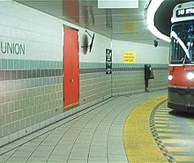
- Anticlockwise underground loop, eastern terminus of the 509 Harbourfront and southern terminus of the 510 Spadina route. A tunnel runs under Bay St. from Queens Quay station. All streetcars enter the station from the tunnel northbound and exit into the tunnel southbound. The minimum radius of curvature for this loop is 14.5 m (48 ft).[2]
Loops at carhouses[]
Roncesvalles Carhouse Loop[]
Clockwise loop through the Roncesvalles Carhouse trackage, at Roncesvalles Ave. and the Queensway, 43°38′21.5″N 79°26′48.0″W / 43.639306°N 79.446667°W, a possible turnback point for westbound 501 Queen and for 504 King in either direction. Streetcars on King or Queen westbound or Roncesvalles southbound can run onto the Queensway westbound, then turn northbound to enter the loop. They can exit the loop onto Roncesvalles Ave. northbound or southbound, with the latter leading onto the Queensway westbound or King or Queen eastbound. The minimum radius of curvature for carhouse trackwork is 11.3 m (37 ft).[2]
 WikiMiniAtlas
No passenger access, no use by buses.
Russell Carhouse Loop[]
There is a counter-clockwise loop around the traffic office at the corner of Connaught Avenue and Queen Street East that can turn streetcars approaching from the west along Queen Street. There is clockwise looping for streetcars approaching from either east or west along Queen Street via Connaught Avenue, Eastern Avenue, north through the yard tracks returning either to Connaught Avenue or directly onto Queen Street. The minimum radius of curvature for the carhouse trackwork is 11.3 m (37 ft).[2]
No passenger access, no use by buses.
Other off-street loops[]
Bingham Loop[]
Anticlockwise loop northwest of Kingston Road and Victoria Park Avenue, eastern terminus for 502 Downtowner and 503 Kingston Road streetcars. Prior to summer 2013, it had the possibility for operators to loop-the-loop.[5] Westbound 12 Kingston Road buses enter the loop as an intermediate stop, and when the streetcars are not running, 22A Coxwell or 322 Coxwell Blue Night buses use it as a terminus. The minimum radius of curvature for this loop is 11.9 m (39 ft).[2]
Distillery Loop[]

Anticlockwise loop, eastern terminus of the 504A King route, on the east side of Cherry St. opposite Distillery Lane in the Distillery District. The Distillery Loop is at the southern end of the Cherry Street streetcar line, which has a junction with the King Street line at its northern end. With the junction, the Distillery Loop can turn cars coming from either direction along King Street. The loop opened on June 19, 2016.
Dufferin Gate Loop[]
Anticlockwise loop northwest of Dufferin Street and the Gardiner Expressway, with it possible to loop-the-loop. During the Canadian National Exhibition this loop is an access to the west end of Exhibition Place via the Dufferin Gates, and is the terminus of the 504B King streetcars.

Earlscourt Loop[]
Clockwise loop southwest of St. Clair Ave. and Lansdowne Ave., 43°40′32.5″N 79°27′03.4″W / 43.675694°N 79.450944°W, possible turnback point for westbound 512 St. Clair streetcars and former terminus for 512L St. Clair streetcars.[6] Streetcars from St. Clair in either direction can turn southbound on Lansdowne to enter the loop, and exit onto St. Clair eastbound.
A cabin is provided for drivers. Northbound 47A Lansdowne buses use the loop as a regularly scheduled turnback point.
Exhibition Loop[]
Anticlockwise loop northeast of Manitoba Dr. and Nova Scotia Ave., western terminus of the 509 Harbourfront and southern terminus of the 511 Bathurst route. Private right-of-way runs along the north side of Manitoba from Fleet St. at Strachan Ave. to the loop. From Fleet westbound, all streetcars continue west along the private right-of-way to the loop, where they cross north under the elevated Gardiner Expressway, run west, and cross back south under the expressway before returning eastbound to Fleet.
During the Ex, this loop is an access to Exhibition Place and is operated as a fare-paid area with ticket booths and turnstiles. At other times these are closed and it is operated as an ordinary stop. Storage tracks are provided so that extra streetcars can be rapidly dispatched for peak traffic, as well as a passing track allowing the two routes to have separate stopping points without conflict.
Exhibition GO Station is adjacent to the loop. Overnight the 307 Bathurst Blue Night and 363 Ossington Blue Night buses use the loop as their southern terminus.
The loop opened in 1996, replacing a previous Exhibition Loop that could not be used by buses and was on land about to be redeveloped.
Fleet Loop[]
Anticlockwise loop on the south side of Fleet Street west of Bathurst Street, in the angle with Lake Shore Blvd., and surrounding the Queen's Wharf Lighthouse. There is no passenger access and no bus access.
Gunns Loop[]
Anticlockwise loop northwest of St. Clair Avenue and at Gunns Road, western terminus for the 512 St. Clair route. All streetcars westbound on St. Clair turn northbound on Gunns, enter the loop westbound, and exit onto St. Clair eastbound. The minimum radius of curvature for this loop is 13.7 m (45 ft).[2]
High Park Loop[]
Anticlockwise loop west of Parkside Drive, opposite Howard Park Avenue, on the east edge of High Park, which is the western terminus for the 506 Carlton route. All streetcars enter the loop from Howard Park westbound and exit onto Howard Park eastbound.
Humber Loop[]
Humber Loop consists of two separate anticlockwise loops, one loop turns cars coming from the east via the Queensway, the other turns cars coming from the west via Lake Shore Boulevard. It is a turnback point for streetcars on the 501 Queen from Neville Park Loop and Long Branch Loop, located south of the Queensway, just west of the Humber River. The loops are on a section of a private right-of-way that connects tracks on the Queensway to the east and Lake Shore Boulevard to the west.
Kipling Loop[]

Anticlockwise loop on the west side of Kipling Ave., north of Lake Shore Blvd., 43°35′55.8″N 79°31′03.3″W / 43.598833°N 79.517583°W, a possible turnback point for westbound 501 Queen streetcars. Streetcars can turn from Lake Shore either eastbound or westbound onto Kipling northbound to enter the loop, and exit onto Kipling southbound, leading to Lake Shore eastbound. The loop was once known as New Toronto Loop.
No bus access in this loop although the 44 Kipling South previously looped until it was extended to the former Lakeshore Asylum. The loop is used by the 145 Humber Bay Express, however.
Long Branch Loop[]
Anticlockwise loop northwest of Lake Shore Boulevard West and Brown's Line is the western terminus for 501 Queen routes.
McCaul Loop[]
Anticlockwise loop northeast of McCaul Street and Stephanie Street, western terminus of the 502 Downtowner and a turnback point for the 501 Queen in either direction. Streetcars both ways on Queen can turn north onto McCaul and then can turn into the loop, exiting onto McCaul southbound to return to Queen either eastbound or westbound. The loop was originally in the open air, but was covered when the Village by the Grange mixed-use development was built over it in 1976.[7] The minimum radius of curvature for this loop is 13.7 m (45 ft).[2]
Neville Park Loop[]
Anticlockwise loop southwest of Queen Street east and Nursewood Road; eastern terminus of the 501 Queen route. All streetcars enter the loop from Queen eastbound and exit onto Nursewood northbound to return to Queen westbound. No passenger access. Eastern terminus of 143 Downtown/Beach Express buses. The minimum radius of curvature for this loop is 13.7 m (45 ft).[2]

Oakwood Loop[]
Anticlockwise loop northeast of St. Clair Ave. and Oakwood Ave., 43°40′50.2″N 79°26′07.8″W / 43.680611°N 79.435500°W, a possible turnback point for route 512 St. Clair in either direction. Streetcars either eastbound or westbound on St. Clair can turn northbound onto Robina Ave., then westbound to enter the loop, exiting onto Oakwood Ave. southbound to return to St. Clair either eastbound or westbound.
No passenger access. Northern terminus of 63B Ossington buses.
Queen–Coxwell Loop[]
Clockwise loop northeast of Queen St. and Coxwell Ave., 43°40′00.4″N 79°18′59.1″W / 43.666778°N 79.316417°W, a possible turnback point for route 506 Carlton in either direction. Streetcars either eastbound or westbound on Gerrard St. can turn southbound on Coxwell to reach the loop, then eastbound to enter the loop, exiting onto Queen westbound to return to Coxwell northbound and turn eastbound or westbound onto Gerrard. The loop exit track briefly overlaps the westbound track on Queen but does not connect with it, leading only onto Coxwell northbound.
No passenger access. This loop is not currently used by buses, although up to the mid-1980s, it was the southern terminus of the Coxwell 22 bus line.

Queens Quay and Spadina Loop[]
Anticlockwise loop northeast of Queens Quay and Spadina Ave (entering from the east side of 410 Queens Quay)., 43°38′18.5″N 79°23′28.5″W / 43.638472°N 79.391250°W, a possible turnback point for 509 Harbourfront or 510 Spadina streetcars in either direction. Streetcars southbound on Spadina can turn eastbound on Queens Quay to reach the loop; streetcars eastbound or westbound on Queens Quay can turn northbound into the loop. Streetcars exiting the loop can turn northbound on Spadina, or southbound on Spadina to reach Queens Quay eastbound or westbound. Although not currently used by buses, this loop was the terminus for the former route 77 Spadina bus until 1997. The loop was demolished in 2013 and finished rebuilt in 2015 as part of the Queens Quay Revitalization Project.[8]
Sunnyside Loop[]
Anticlockwise loop northeast of the Queensway and Sunnyside Avenue, near the southwest corner of Roncesvalles Carhouse. 43°38′20.0″N 79°26′53.5″W / 43.638889°N 79.448194°W Streetcars enter westbound on the Queensway and exit southbound on Sunnyside Avenue, returning to the Queensway eastbound. Possible turn back point for the 501 Queen westbound. Part of the TTC's 5-year service plan and 10-year outlook reports published in 2020 show route 501 Queen split into 2 sections: 501A streetcars would operate between the existing eastern terminus at Neville Park and Sunnyside loop, while 501B streetcars would operate between the existing western terminus at Long Branch and a new loop near Broadview Ave. and Queen St. East (see "future loops"). This service change was proposed for July 2020 but has not been implemented yet.
Wolseley Loop[]
Anticlockwise loop northeast of Bathurst St. and Wolseley St., 43°38′53.8″N 79°24′14.6″W / 43.648278°N 79.404056°W, a possible turnback point for westbound route 501 Queen streetcars, route 504 King in either direction, northbound 511 Bathurst streetcars, as well as an alternate western terminus for the 502 Downtowner route if McCaul Loop is unavailable. Streetcars eastbound or westbound on King St. or westbound on Queen St. can turn northbound on Bathurst, then can turn eastbound on Wolseley to enter the loop northbound, exiting onto Bathurst southbound to return to Queen St. eastbound or King St. eastbound or westbound.
rare bus access, however no passenger access. A cabin for drivers is provided.
Woodbine Loop[]
Clockwise loop northeast of Queen St. and Kingston Rd., 43°40′04.8″N 79°18′41.5″W / 43.668000°N 79.311528°W, a possible turnback point for eastbound route 501 Queen and for 502 Downtowner and 503 Kingston Road in either direction. Streetcars eastbound on Queen can turn northeast (nominally east) onto Kingston Rd.; streetcars running northeast or southwest on Kingston Rd. can turn eastbound into the loop, exiting onto Queen westbound, and can then turn northeast from Queen onto Kingston Rd. The minimum radius of curvature for this loop is 11.2 m (37 ft).[2]
The name Woodbine refers not to Woodbine Ave., almost 500 metres to the east, but to the former Woodbine Race Course, which was once directly opposite the loop on the south side of Queen. The racetrack was renamed Greenwood Raceway after the New Woodbine Racetrack opened in another part of the city in 1957; Greenwood Raceway was demolished in 1994. Despite this, the "Woodbine Loop" name persists.
No passenger access.
Named on-street loops[]
In addition to these named locations where a streetcar just runs around one or two city blocks to reverse, there are several places on the system where a longer loop around city streets is possible. The western terminus of the 503 Kingston Road, for example, is an on-street loop via Church St. southbound, Wellington St. westbound, York St. northbound, and King St. eastbound.

Charlotte Loop[]
Clockwise on-street loop via King St. westbound, Spadina Ave. northbound, Adelaide St. eastbound, and Charlotte St. southbound, 43°38′47″N 79°23′38″W / 43.64639°N 79.39389°W, a possible turnback point for routes 504 King, and 510 Spadina in either direction. It is used regularly to short-turn southbound 510 Spadina streetcars,[9] and to turn westbound 503 Kingston Rd streetcars.[10][11] Streetcars come from/onto King eastbound or westbound and Spadina northbound or southbound.[12]
College Loop[]
Anticlockwise on-street loop via Lansdowne Ave. northbound, College St. going southwest (nominally westbound), and Dundas St. going southeast (nominally eastbound), 43°39′02″N 79°26′23.4″W / 43.65056°N 79.439833°W, a possible turnback point for routes 505 Dundas and 506 Carlton in either direction. Streetcars can enter and exit the loop from/onto either Dundas or College in either direction.
Future Loops[]
A loop near Park Lawn Road and Lake Shore Boulevard had also been proposed but the decision was made to remove it from the TTC budget until 2017–2019.[13] In the 5-year service plan/10-year outlook report released by the TTC in 2020,[citation needed] the route of the 504B King streetcar would be altered to operate between Broadview Station and Humber Loop, and later to a new loop near Park Lawn Road. Construction on this loop had not begun as of July 2020.
The same 2020 report also suggests the 501 Queen streetcar be split into 2 sections, with the 501A operating between Neville Park and Sunnyside loops and the 501B operating between Long Branch; a new loop would be constructed on the east side of Broadview Avenue just north of Queen St. East, on lands owned by the TTC and currently used as a municipal Green-P parking lot. As of July 2020, construction of a new Broadview/Queen loop had not yet been announced or commenced.
Former loops[]


| Name | Location | Streetcar route last using loop | Status and notes |
|---|---|---|---|
| Asquith Loop | Church Street north of Bloor Street East | Church | Later bus loop, now redeveloped as office complex |
| Avon Loop | Weston Road & Rogers Road[14] | Weston Road | Later trolleybus loop, now buses. Currently under renewal for new streetcar/bus loop in 2014. |
| Bedford Loop | Bloor Street West & Bedford Road | Bloor | Partially redeveloped, partially parking lot |
| Bicknell Loop | Rogers Road & Bicknell Avenue | Rogers Road | Belongs to the City of Toronto.[14] Currently under renewal for new streetcar/bus loop in 2014. |
| Birchmount Loop | Birchmount Road & Kingston Road[15] | Kingston Rd. | Sold, redeveloped into condominiums |
| Caledonia Loop | St. Clair Avenue West & Station Street | St. Clair | Commercial development |
| Christie Loop | Dupont Street & Christie Street | Dupont | Redeveloped |
| City Hall Loop | on-street: Louisa, James, Albert & Bay Streets | Dundas | Louisa St. closed and redeveloped; tracks removed from other streets |
| Danforth (or Danforth-Coxwell) Loop | Danforth Avenue & Coxwell Avenue | Coxwell | Was part of Danforth Carhouse property; now redeveloped |
| Erindale Loop | Broadview Avenue & Erindale Avenue north side of street, opposite parkette |
King | Redeveloped |
| (old) Exhibition Loop | north of Princes Boulevard, 1/4 mile (400 m) west of Strachan | Bathurst | Redeveloped into National Trade Centre (now Direct Energy Centre) |
| Ferry (or Ferry Docks) Loop | Queens Quay West west of Bay Street | Dupont | Parking lot |
| Gilbert Loop | Eglinton Avenue West & Gilbert Street | Oakwood | Parkette |
| Glen Echo Loop | Yonge Street & Glen Echo Avenue | Yonge | Terminal shed and loop removed and now parking lot for Loblaws store. Car barn (storage for about 12 single truck (small) streetcars) was converted into a car dealership from 1950s to 1980s then demolished for current Loblaws store. Roadway to loop now part of Doncliffe Drive. |
| Hillingdon Loop | Danforth Avenue & Hillingdon Avenue | Bloor | Was part of Danforth Carhouse property |
| Jane Loop | Bloor Street West & Jane Street | Bloor | Now redeveloped as a medical office building |
| Keele Loop | Keele Street north of St. Clair Avenue West | 512 St. Clair | Redeveloped |
| Keele Stn. Loop | Indian Grove & Bloor Street West | Bloor | Temporary loop 1966–68; redeveloped |
| Lawton Loop | north of Yonge Street and Lawton Boulevard intersection | Yonge | Lawton Parkette |
| Lipton Loop | Lipton Avenue & Pape Avenue | Harbord | Now the site of Pape Station and bus loop |
| Luttrell Loop | Danforth Ave., between Luttrell & Kelvin Avenues (west of Victoria Park Ave.) | Bloor | Sold, redeveloped into housing |
| Main Loop | Main Street north of Danforth Avenue | Carlton | Rebuilt into Main Street Station Loop |
| Mt. Pleasant Loop | Eglinton Avenue East & Mount Pleasant Road | Mt. Pleasant | Also known as Eglinton Loop. Later trolleybus loop, now buses. Originally open-air, now under an apartment building. |
| Mutual Loop | Mutual Street & Queen Street East | Lakeshore | Redeveloped, now a parking lot |
| Moore Park Loop | Mount Pleasant Road & St. Clair Avenue East | St. Clair | Loring-Wyle Parkette |
| Northlands Loop | Weston Road & Northlands (or Northland) Avenue.[14] | Weston Rd. | Redeveloped as commercial plaza |
| Park Loop | Bloor Street West & High Park Avenue | Bloor | Part of High Park |
| Parliament Loop | King Street East | Parliament | Later bus loop only; now under part of a car dealership. |
| Pine Loop/Wye | Lakeshore Road West and Pine Avenue South, Mississauga | Port Credit | Now Peel dealership lot. |
| Prescott Loop | Prescott Avenue and St. Clair Avenue West | Dovercourt | Now St. Clair Garden Parkette |
| Royce Loop | Lansdowne Avenue & Dupont Street | Harbord | Redeveloped |
| Runnymede Loop | Dundas Street West & Runnymede Road | Dundas | Later trolleybus loop, now buses |
| St. Clair (or Wychwood) Carhouse Loop | Wychwood Avenue & Benson Avenue | St. Clair | Reduced to wye after carhouse closed, then closed |
| St. Clarens Loop | St. Clarens Avenue & Davenport Road | Harbord | Primrose Avenue Parkette |
| Simcoe Loop | Front Street West & Simcoe Street | Yonge | Redeveloped |
| Small Arms Loop | Long Branch Small Arms factory, on Lakeshore Road almost 0.5 mile west of Long Branch Loop | Long Branch | For temporary 1942–45 extension of route into Toronto Township (today's Mississauga) Shelter removed after 1958 and now loop area is Lakeshore Park east of Deta Road and Lakeshore Road. |
| Terauley | on-street: Bay, Richmond, Victoria, Queen | Bay | Bus loop |
| Townsley | north of St. Clair Avenue West & Old Weston Road | 512 St. Clair | Bus loop |
| Vaughan Loop | north of Bathurst Street/Vaughan Road intersection | Bathurst | Redeveloped |
| Viaduct Loop | Bloor Street East & Parliament Street | Parliament | Parkette |
| Vincent Loop | across from Dundas West Station | King | Redeveloped as Crossways Mall and condos |
| Woodbine Stn. Loop | Cedarvale Avenue & Strathmore Boulevard | Danforth | Temporary loop 1966–68; now part of parking lot. Some loop track still visible on Strathmore Blvd. |
Former wyes[]
As an alternative to a loop, a streetcar can also be turned using a manoeuvre similar to a three-point turn, involving at least two switches and a suitable layout of connecting tracks. This can be done if necessary at any intersection or other track junction where suitable tracks exist, but the TTC also had a few wye tracks with no other purpose. There are none of these any more; the table shows some of the last ones to be removed.
| Name | Location | Date closed | Notes |
|---|---|---|---|
| Adelaide Wye | Bathurst Street & Adelaide Street West | 1973 | Remnant of through tracks on Adelaide Street |
| Glencairn Wye | Yonge Street & Glencairn Avenue | 1954 | Closure with the opening of Yonge subway and closure of Yonge streetcar |
| Hillside Wye | Lake Shore Boulevard West and Hillside Avenue | 2002 | Track removed |
| Junction Wye | Keele Street & Junction Road | 1963 | Removed as part of closure of Bloor streetcar route |
| Pine Wye | Pine Avenue South and Lakeshore Road West | 1950 | Converted as loop |
| St. Clair Carhouse Wye | Wychwood Avenue & Benson Avenue | 1998 | Access tracks for former carhouse retained when it closed in 1978 |
See also[]
References[]
- ^ "LF LRV Procurement Project - Cancellation of RFP & Way Forward" (PDF). Toronto Transit Commission. August 27, 2008. p. 17. Archived from the original (PDF) on November 6, 2018. Retrieved November 5, 2018.
- ^ Jump up to: a b c d e f g h i j k l Lam, Stephen (January 12, 2016). "Transportation Research Board" (PDF). Transportation Research Board. p. 9. Archived from the original (PDF) on November 11, 2018. Retrieved November 10, 2018.
- ^ Bow, James (May 17, 2020). "The Canadian Light Rail Vehicles". Transit Toronto. Retrieved May 19, 2020.
- ^ Calnan, John (July 2006). "Toronto Transit Commission - 2006 Streetcar Track Layout and Route Map" (PDF). Toronto Transit Commission.
- ^ "Venerable Bingham Loop - Transit Toronto - Content". transittoronto.ca. Retrieved April 18, 2016.
- ^ "Route 512L - The Earlscourt Streetcar - Transit Toronto - Content". transittoronto.ca. Retrieved April 18, 2016.
- ^ A Brief History of McCaul Loop
- ^ http://www.waterfrontoronto.ca/explore_projects2/central_waterfront/queens_quay/constructing_the_community___queens_quay
- ^ Introducing Charlotte Loop
- ^ "503 Kingston Rd - Service change - King Street Transit Pilot". Toronto Transit Commission. February 19, 2018. Archived from the original on February 6, 2018.
- ^ "Seasonal service changes and improvements". Toronto Transit Commission. June 18, 2020. Archived from the original on June 20, 2020. Retrieved June 20, 2020.
- ^ "TTC service improvements and changes". Toronto Transit Commission. September 2, 2018. Archived from the original on August 30, 2018. Retrieved September 2, 2018.
- ^ "Park_Lawn_Streetcar_Loop_2.pdf" (PDF). TTC. Retrieved April 17, 2016.
- ^ Jump up to: a b c
Bow, James (February 17, 2013). "A History of the Rogers/Weston Streetcar Loops (Northlands, Avon and Bicknell)". Transit Toronto. Archived from the original on September 21, 2013. Retrieved July 20, 2014.
In 1972, the TTC decided to retain its streetcar operations within the City of Toronto, but needed to rebuild its fleet of PCCs to keep the system going until a replacement vehicle could be found. In order to have enough spares to maintain service while the rebuilds were continuing, it was decided to end streetcar service on Rogers Road.
- ^
Bow, James (August 24, 2013). "Remembering Birchmount Loop". Transit Toronto. Archived from the original on September 21, 2013. Retrieved February 18, 2014.
The easternmost streetcar loop in the TTC's history is Birchmount Loop, located at the Kingston Road / Birchmount Avenue intersection inside the old City of Scarborough.
External links[]
| Wikimedia Commons has media related to TTC streetcar loops. |
- TTC Toronto Track Diagram 1966
- Toronto Transit Commission Track Diagram 1973
- TTC Streetcar Track Map (1995)
| hide | ||
|---|---|---|
| Bus |    | |
| Subway | ||
| Streetcars | ||
| History | ||
| Predecessors |
| |
| Facilities | ||
| Proposed | ||
| Miscellaneous | ||
Italics indicate a project under construction | ||
- Toronto streetcar loops