Ontario Line
| Ontario Line | ||||||||||||||||||||||||||||||||||||||||||||||||||||||||||||||||||||||||||||||||||||||||||||||||||||||||||||||||||||||||||||||||||||||||||||||||||||||||||||||||||||||||||||||||||||||||||||||
|---|---|---|---|---|---|---|---|---|---|---|---|---|---|---|---|---|---|---|---|---|---|---|---|---|---|---|---|---|---|---|---|---|---|---|---|---|---|---|---|---|---|---|---|---|---|---|---|---|---|---|---|---|---|---|---|---|---|---|---|---|---|---|---|---|---|---|---|---|---|---|---|---|---|---|---|---|---|---|---|---|---|---|---|---|---|---|---|---|---|---|---|---|---|---|---|---|---|---|---|---|---|---|---|---|---|---|---|---|---|---|---|---|---|---|---|---|---|---|---|---|---|---|---|---|---|---|---|---|---|---|---|---|---|---|---|---|---|---|---|---|---|---|---|---|---|---|---|---|---|---|---|---|---|---|---|---|---|---|---|---|---|---|---|---|---|---|---|---|---|---|---|---|---|---|---|---|---|---|---|---|---|---|---|---|---|---|---|---|---|---|
| Overview | ||||||||||||||||||||||||||||||||||||||||||||||||||||||||||||||||||||||||||||||||||||||||||||||||||||||||||||||||||||||||||||||||||||||||||||||||||||||||||||||||||||||||||||||||||||||||||||||
| Status | Planned | |||||||||||||||||||||||||||||||||||||||||||||||||||||||||||||||||||||||||||||||||||||||||||||||||||||||||||||||||||||||||||||||||||||||||||||||||||||||||||||||||||||||||||||||||||||||||||||
| Owner | Metrolinx | |||||||||||||||||||||||||||||||||||||||||||||||||||||||||||||||||||||||||||||||||||||||||||||||||||||||||||||||||||||||||||||||||||||||||||||||||||||||||||||||||||||||||||||||||||||||||||||
| Locale | Toronto, Ontario | |||||||||||||||||||||||||||||||||||||||||||||||||||||||||||||||||||||||||||||||||||||||||||||||||||||||||||||||||||||||||||||||||||||||||||||||||||||||||||||||||||||||||||||||||||||||||||||
| Termini | Science Centre, Exhibition | |||||||||||||||||||||||||||||||||||||||||||||||||||||||||||||||||||||||||||||||||||||||||||||||||||||||||||||||||||||||||||||||||||||||||||||||||||||||||||||||||||||||||||||||||||||||||||||
| Stations | 15 | |||||||||||||||||||||||||||||||||||||||||||||||||||||||||||||||||||||||||||||||||||||||||||||||||||||||||||||||||||||||||||||||||||||||||||||||||||||||||||||||||||||||||||||||||||||||||||||
| Service | ||||||||||||||||||||||||||||||||||||||||||||||||||||||||||||||||||||||||||||||||||||||||||||||||||||||||||||||||||||||||||||||||||||||||||||||||||||||||||||||||||||||||||||||||||||||||||||||
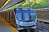
| Type | Light metro[1] | |||||||||||||||||||||||||||||||||||||||||||||||||||||||||||||||||||||||||||||||||||||||||||||||||||||||||||||||||||||||||||||||||||||||||||||||||||||||||||||||||||||||||||||||||||||||||||||
| System | Toronto subway | |||||||||||||||||||||||||||||||||||||||||||||||||||||||||||||||||||||||||||||||||||||||||||||||||||||||||||||||||||||||||||||||||||||||||||||||||||||||||||||||||||||||||||||||||||||||||||||
| History | ||||||||||||||||||||||||||||||||||||||||||||||||||||||||||||||||||||||||||||||||||||||||||||||||||||||||||||||||||||||||||||||||||||||||||||||||||||||||||||||||||||||||||||||||||||||||||||||
| Planned opening | 2030[2] | |||||||||||||||||||||||||||||||||||||||||||||||||||||||||||||||||||||||||||||||||||||||||||||||||||||||||||||||||||||||||||||||||||||||||||||||||||||||||||||||||||||||||||||||||||||||||||||
| Technical | ||||||||||||||||||||||||||||||||||||||||||||||||||||||||||||||||||||||||||||||||||||||||||||||||||||||||||||||||||||||||||||||||||||||||||||||||||||||||||||||||||||||||||||||||||||||||||||||
| Line length | 15.5 km (9.6 mi) | |||||||||||||||||||||||||||||||||||||||||||||||||||||||||||||||||||||||||||||||||||||||||||||||||||||||||||||||||||||||||||||||||||||||||||||||||||||||||||||||||||||||||||||||||||||||||||||
| Track gauge | 1,435 mm (4 ft 8+1⁄2 in) | |||||||||||||||||||||||||||||||||||||||||||||||||||||||||||||||||||||||||||||||||||||||||||||||||||||||||||||||||||||||||||||||||||||||||||||||||||||||||||||||||||||||||||||||||||||||||||||
| Electrification | 1500 V DC overhead | |||||||||||||||||||||||||||||||||||||||||||||||||||||||||||||||||||||||||||||||||||||||||||||||||||||||||||||||||||||||||||||||||||||||||||||||||||||||||||||||||||||||||||||||||||||||||||||
| ||||||||||||||||||||||||||||||||||||||||||||||||||||||||||||||||||||||||||||||||||||||||||||||||||||||||||||||||||||||||||||||||||||||||||||||||||||||||||||||||||||||||||||||||||||||||||||||
The Ontario Line is a planned rapid transit line in Toronto, Ontario, Canada. Its northern terminus would be at Eglinton Avenue and Don Mills Road, at Science Centre station, where it would connect with Line 5 Eglinton. Its southern terminus would be at the existing Exhibition GO Station on the Lakeshore West line. The Ontario Line was announced by the Government of Ontario on April 10, 2019.[3][4] The Ontario government estimated the cost at $10.9 billion for this 15.5-kilometre (9.6 mi) line and hoped to complete the project by 2027,[3] a completion date that had been revised to 2030 by December 2020.[2]
Project history[]

The City of Toronto had been developing a rapid transit line, known as the "Relief Line South",[a] between Pape station on Line 2 Bloor–Danforth and Osgoode station on Line 1 Yonge–University. In the early months of 2019, the Ontario government announced its intentions to take over subway construction in Toronto. In a surprise announcement in April 2019, the Ontario government announced the Ontario Line, which at that time appeared to incorporate much of the routing and many of the station locations of the Relief Line.[5] Unlike the City design, the Ontario Line would be a "standalone" line, one that would use lighter rolling stock and shorter trainsets than the Toronto Transit Commission's existing subway lines.[6] Members of Toronto City Council expressed their concerns that the new line would set back the delivery of rapid transit and potentially waste money the City of Toronto had already spent on the Relief Line's design.
Metrolinx prepared the plan for the Ontario Line in just three months based on a proposal by transit consultant Michael Schabas. Metrolinx hired Schabas in December 2018 to lead a team to transform the Relief Line plans into the Ontario Line. Schabas was a proponent of using lighter metro vehicles such as those used for the London's Docklands Light Railway, such vehicles being suitable for steeper grades and elevated structures. A draft plan was ready by January 31, 2019. Doug Ford approved the plan after a February 26 presentation. Metrolinx kept the project a secret until the government chose to announce it on April 10.[7]
As initially announced in April 2019, the route of the Ontario Line seemed to follow much of the route of the Relief Line, beginning at Exhibition Place, travelling northeast to King and Bathurst Streets, then northeast to Spadina Avenue and Queen Street. It then proceeded eastward through downtown along Queen Street before turning southeast in the area of Parliament Street south to Eastern Avenue. The line had one station on King and Sumach, then made an east–west crossing of the Don River to a station at Broadview and Eastern Avenue. The line proceeded northeast to Pape Avenue and Danforth Avenue and continued north along Pape, making a north–south crossing of the Don River to the Thorncliffe Park neighbourhood. The line continued northeast along Don Mills Road to terminate at Don Mills Road and Eglinton Avenue.[8]
The announcement that the line would extend to a new station at Ontario Place stirred controversy, as Ontario Premier Doug Ford had spoken of transforming Ontario Place, previously a family-oriented venue, into an adult-oriented casino complex, and some suspected that the plan to have the transit line extend to Ontario Place was aimed at visiting gamblers, not the citizens of Ontario.[9][10][11][12][13] Ford has denied that the extension is related to any casino plans.[14] The Globe and Mail reported that no previous plan had ever considered making Ontario Place a rapid transit destination and that the announcement surprised everyone, including Mayor of Toronto John Tory.[11]
In July 2019, the Toronto Star obtained and reported on confidential documents from Metrolinx. They showed that the proposed route would be markedly different from that of the Relief Line South and involve significant lengths of at-grade or elevated track. The Ontario Place station was eliminated with an Exhibition station added near the Exhibition GO Station. The section between Queen/Sherbourne and Gerrard stations would come to the surface and mostly follow a railway right-of-way instead of being tunnelled. The new route would substitute a Corktown station about 500 metres (1,600 ft) west of the proposed location for Sumach station on the Relief Line. The Ontario Line would share less than half the planned route of the Relief Line between Osgoode and Pape stations.[15]
In October 2019, Mayor John Tory and Premier Doug Ford reached a tentative deal in which the city would endorse the line and the TTC's subway network would not be taken over by the provincial government.[16] The deal was later approved by Toronto City Council in a 22–3 decision.[17]
The Ontario Line is being delivered as three separate public-private partnership (P3) procurement contracts: one rolling stock, systems, operations and maintenance contract for the entire 15.5-kilometre (9.6 mi) line and two separate civil, stations and tunnel contracts – one for the southern segment and one for the northern segment of the line. The schedules for each contract will be aligned to allow for a single in-service date for the Ontario Line.[18]
Procurement[]
On June 2, 2020, Infrastructure Ontario (IO) and Metrolinx issued two requests for qualifications (RFQs) for the southern civil, stations and tunnels contract and the rolling stock, systems, operations and maintenance contract – marking the first phase of procurement for the Ontario Line. The RFQ for the northern civil, stations and tunnel contract, the northern portion of the Ontario Line from Gerrard Station to the Ontario Science Centre, is expected to be issued in early 2022.[19]
Concerns[]
After a draft of the Ontario Line's business case was disclosed in July 2019, a number of concerns were raised by transit experts:
- Doubts were expressed that the line could be completed within budget and by 2027. Metrolinx plans to start the procurement process in 2020 to allow bidding companies to comment on the feasibility of the 2027 completion date.[20] The estimated completion had been revised to 2030 by December 2020.[2]
- It may be challenging to fit the Ontario Line along GO Transit's Lakeshore East corridor. The Ontario Line would need to be added to three existing overpasses.[20] If the Ontario Line requires widening of the Lakeshore East embankment, property acquisitions may be required including nearby houses, businesses and community facilities.[21][22] In September 2020, Metrolinx said the platform area of the former Grand Trunk Railway's Riverdale railway station gave the rail corridor extra width at Queen Street; thus, the Ontario Line would not impact the adjacent Jimmie Simpson Community Centre.[23]
- Flood mitigation projects and reconstruction of the Gardiner Expressway at Lower Don River may impede Ontario Line construction.[20]
- There are doubts that passengers can alight and board smaller Ontario Line trains quickly enough to achieve the projected 90-second train frequency. Metrolinx insists the frequency can be met by reducing station dwell times.[20]
- There is a concern that winter conditions may adversely affect train operations on an elevated track like Line 3 Scarborough, which also uses light metro technology.[20]
- The elevated structures may have a greater environmental impact with respect to noise, vibration and visual presence than with an underground right-of-way. Metrolinx proposes using mitigation strategies involving "systems, maintenance and track design" to reduce noise and vibration, and new community spaces and parks "to offset (the) visual impact and footprint of the elevated structure".[24] Another design decision Metrolinx must make is whether the elevated structure along Don Mills Road would be above or beside the road.[25] In September 2020, Metrolinx said it would build noise walls along the rail corridor between Gerrard and East Harbour stations.[23]
- Some of the savings for surface construction may be partially offset by the cost of building surface-to-tunnel transitions at Cherry and Gerrard Streets.[21]
- Operating costs for the above-ground sections may be higher due to exposure to the elements.[21]
- Operating the Ontario Line along an elevated Lakeshore East embankment might require slower speeds in order to navigate grades and curves.[21]
Description[]
Route[]
The following route description is based on a revised plan issued by Metrolinx in September and October 2020, plus a revision published in April 2021.
The northern terminus of the Ontario Line would be Science Centre station at Don Mills Road and Eglinton Avenue. This station would be a transfer point for Line 5 Eglinton and TTC buses. The Ontario Line platform would be on an elevated structure above Science Centre station's bus terminal, located north of Eglinton Avenue on the east side of Don Mills Road.[26]
Continuing south on an elevated structure, the line would cross Eglinton Avenue and then cross to the west side of Don Mills Road, passing through Flemingdon Park station located on a northwest corner opposite Gateway Boulevard. Immediately south of this station, the line would turn west along the Hydro One right-of-way, and cross the Don Valley on a new bridge. Continuing west on the other side of the valley, the line would pass the Ontario Line maintenance and storage facility. The line would jog south to Overlea Boulevard and then jog west on the north side of that street on an elevated structure. The line would pass through Thorncliffe Park station, which would be over the western portion of Thorncliffe Park Boulevard. Continuing west on an elevated structure, the line would curve south over Millwood Road across the Don Valley on a new bridge roughly parallel and west of Leaside Bridge. On the south side of the valley crossing, the line would enter a tunnel under Minton Place.[26]
From Minton Place, the line would continue south under Pape Avenue, passing through Cosburn and Pape stations. The tunnel, mainly under Pape Avenue, would bow slightly to the west at Cosburn station, and slightly to the east at Pape station to avoid digging up the street to construct the station structures. At Pape station, the Ontario Line would connect with Line 2 Bloor–Danforth.[26]
South from Pape station, the line would travel roughly under Pape Avenue, emerging to the surface just north of Gerrard Street. The line would then enter Gerrard station on an elevated structure over the intersection of Gerrard Street and Carlaw Avenue. South of Gerrard station, the Ontario Line would run along the northwest side of GO Transit's Lakeshore East rail corridor located on an embankment. (The rail corridor has three tracks with provision for a fourth. With the construction of the Ontario Line, the corridor would eventually have six tracks.) The route would continue along the railway right-of-way, passing Leslieville station at Queen Street West and continuing to East Harbour station, east of the Don River, on the south side of Eastern Avenue, where a new GO train station would be built on the surface. The Ontario Line would cross the Don River on a new bridge located on the north side of the existing rail bridge. After crossing the river, the line would pass the GO Transit Don Yard before descending into a tunnel just east of Cherry Street.[27]
The route would turn north under the east side of Berkeley Street through Corktown station at King Street. Between King and Queen Streets, the line would make a broad north-to-west curve to run west under Queen Street through Moss Park station (between Shuter and Sherbourne Streets), Queen station (at Yonge Street) and Osgoode station (at University Avenue). The line would continue westward to a Queen/Spadina station, then diagonally southwest via a King/Bathurst station to Strachan Avenue. The line would turn westward again, coming to the surface just west of Strachan Avenue on the north side of the railway corridor along Exhibition Place, before arriving at Exhibition station, its southern terminus.[28][29]
Maintenance and storage facility[]
| Metrolinx media | |
|---|---|
The Ontario Line maintenance and storage facility (OLMSF) will occupy a 17.5-hectare (43-acre) site north of Overlea Boulevard, between Beth Nealson Drive and the CP Rail Corridor. It will be located near the future Thorncliffe Park station. The facility would store 200 trains and have a maximum capacity of 250.[26][30]
Miscellaneous[]
Metrolinx is considering a means to link Exhibition station to Ontario Place. The link could be a people mover, cable cars or some other option.[25]
The Government of Ontario plans to use smaller train sets and a smaller gauge for the Ontario Line than those used on the Toronto subway system.[14] The City of Toronto's "Relief Line" proposal used the same conventional heavy rail subway vehicles as used on Lines 1, 2, and 4.[9][31] By using driverless trains with automatic train control and more frequent trains, the government expects that the line would have a similar capacity to traditional heavy rail. The government also claims the alternate technology will reduce construction time and cost, as single tunnels rather than dual tunnels could be utilized.[citation needed]
Most of the proposed stations on the Ontario Line will facilitate transfers between other forms of public transport, and the majority will provide transfers to other rail-based transportation (GO Transit, TTC subway and streetcar).
According to Metrolinx, the new line will do more than provide relief to overcrowding on Toronto's existing subway system: it will provide new connections to the communities of Flemingdon Park and Thorncliffe Park.[32]
As Line 3 Scarborough is expected to be decommissioned well before the opening of the Ontario Line, it is expected the Ontario Line will inherit Line 3's number and line colour of blue on maps and wayfinding.[33]
Stations[]
The following information, largely from the Metrolinx's Draft Environmental Conditions Report from the fourth quarter of 2020, is subject to change.[26][23][28][29]
| Station | Type | Neighbourhood | Connections | Notes |
|---|---|---|---|---|
| Science Centre | Elevated | Flemingdon Park | Integrated with station under construction at Don Mills Road and Eglinton Avenue | |
| Flemingdon Park | Elevated | Flemingdon Park | West side of Don Mills Road north of Gateway Boulevard | |
| Thorncliffe Park | Elevated | Thorncliffe Park | On Overlea Boulevard over Thorncliffe Park Drive West | |
| Cosburn | Underground | Old East York | At Cosburn Avenue and Pape Avenue | |
| Pape | Underground | Greektown | Integrated with an existing station at Pape and Danforth | |
| Gerrard | Railway embankment | Riverdale | Located at the intersection of Gerrard Street and Carlaw Avenue, along the Lakeshore East and Stouffville GO Transit rail corridors | |
| Leslieville | Railway embankment |
|
Located at the intersection of Queen Street East and GO Transit's Lakeshore East / Stouffville rail corridor | |
| East Harbour | Railway embankment |
|
Located along GO Transit's Lakeshore East / Stouffville rail corridor between Eastern Avenue and the Don River | |
| Corktown | Underground | Corktown | At Berkeley Street and King Street East[15] | |
| Moss Park[34] | Underground | Under Queen Street East between George Street and Sherbourne Street | ||
| Queen | Underground | Downtown | Integrated with an existing station at Queen Street and Yonge Street | |
| Osgoode | Underground | Downtown | Integrated with an existing station at Queen Street West and University Avenue | |
| Queen/Spadina | Underground | Fashion District | At the intersection of Queen Street West and Spadina Avenue | |
| King/Bathurst | Underground | Fashion District | At the intersection of King Street West and Bathurst Street | |
| Exhibition | At grade | Liberty Village | On the north side of the Lakeshore West railway corridor north of Exhibition Place |
| Metrolinx exhibits | |
|---|---|
Science Centre[]
The Ontario Line will serve Science Centre station at Eglinton Avenue, providing a connection to Line 5 Eglinton. The elevated Ontario Line station will be along Don Mills Road at the northeast corner of its intersection with Eglinton Avenue. Passengers will be able to access rail services from either the station's southwest or northeast entrance as well as from the adjacent bus terminal. The station will have three levels, with the Line 5 platforms below street level, the bus terminal at street level and the Ontario Line platforms above street level. Escalators, elevators and interior corridors will be available to facilitate transfers.[35]
There will be tail tracks at the north end of the Ontario Line platforms extending north past Wynford Drive. These will be used to store trains and to provide for future northward expansion.[35]
Flemingdon Park[]
Flemingdon Park station is a proposed elevated Ontario Line station to be located on the west side of Don Mills Road at the north side of its intersection with Gateway Boulevard. It will be constructed at the site of a parking lot. As of June 2021, Metrolinx has not indicated the location of entrances and exits for this station. However, this station will be closer to the Ontario Science Centre's main entrance than Science Centre station.[35]
Thorncliffe Park[]
Thorncliffe Park station is a proposed elevated Ontario Line station to be located on the north side of Overlea Boulevard over Thorncliffe Park Drive. (Overlea Boulevard and Thorncliffe Park Drive intersect at two places within Thorncliffe Park. The station is at the western intersection.) As of June 2021, Metrolinx has not indicated the location of entrances and exits for this station.[35]
Cosburn[]
Cosburn station is a proposed underground Ontario Line station to be located at Cosburn Avenue and have a centre platform. It will be located under the west side of Pape Avenue so as to avoid digging up Pape Avenue itself during construction. As of June 2021, Metrolinx has not indicated the location of entrances and exits for this station.[35]
Pape[]
The Ontario Line will serve the existing Pape station, providing a connection to Line 2 Bloor–Danforth at Danforth Avenue. Running slightly east of Pape Avenue, the Ontario Line will have a centre platform under Line 2 at the station. Metrolinx expects the Ontario Line connection at Pape will reduce rush-hour congestion at Bloor–Yonge station by 22 percent.[35] There are plans for an additional station entry directly from Danforth Avenue.[36]:1:24:00
| Metrolinx exhibits | |
|---|---|
Gerrard[]
Gerrard is a proposed Ontario Line station to be located diagonally over the intersection of Gerrard Street East and Carlaw Avenue. The station structure will be separate from the parallel railway bridge and embankment. The Ontario Line station will have centre platforms and two entrances. One entrance will be on the east side of Carlaw Avenue north of Gerard Street. A second entrance will be on the south side of Gerrard Street adjacent to Gerrard Carlaw Parkette.[27]
Leslieville[]
Leslieville is a proposed Ontario Line station to be located on the railway bridge over Queen Street East on the boundary between the Riverside (west side) and Leslieville neighbourhoods. One Metrolinx exhibit suggests that the station will be named Riverside/Leslieville. The elevated Ontario Line station will have a centre platform and two entrances. One entrance will be on the north side of Queen Street under the bridge. A second entrance will be on the south side of Queen Street at the west side of the railway embankment. The GO Transit rail corridor will be on the east side of the Ontario Line tracks, but there will be no GO Transit railway station here. Metrolinx plans to rebuild the bridge over Queen Street in order to have it rise 5 metres (16 ft) over street level instead of the current 3.9 metres (13 ft).[27]
East Harbour station[]
East Harbour is a proposed subway and commuter railway station to be located between Eastern Avenue and the Don River along GO Transit's Lakeshore East / Stouffville rail corridor. East Harbour will host Ontario Line and GO Transit trains. It is also a proposed station for SmartTrack service. There is also a future proposal to extend streetcar service south along Broadview Avenue into the Port Lands in the vicinity of East Harbour station. The station will service a future office development.[37]
East Harbour station will be built along the existing railway embankment. The station would have six tracks passing through it, two tracks for the Ontario Line on the northwest side of the railway embankment plus four tracks for GO trains on its southeast side. At East Harbour, there would be three platforms each serving a pair of tracks: one platform for Ontario Line trains, one for westbound GO trains and another for eastbound GO trains.[38][39]
Corktown[]
Corktown station will be located at the southeast corner of King and Berkeley Streets. There will be an emergency exit on the north side of Front Street, just east of Berkeley Street. The Ontario Line tunnel will be under the land on the east side of Berkeley Street. The two city blocks bounded by Berkeley, King and Parliament Streets, and north of Parliament Square Park will be razed for tunnel launch shafts. (Construction will not affect the park itself.) The southern city block is the site of the First Parliament, and Metrolinx will allow archeologists to examine the site for artifacts before it is destroyed by construction. Once the site is prepared, a tunnel-boring machine will launch north and west from the site while another launches south and east towards the Don Yard.[40][41]
Moss Park[]
Moss Park station will be located at the northwest corner of Queen and Sherbourne Streets next to the Moss Park Arena. At this point, the line will be under the southern edge of Moss Park (where the Moss Park Armoury is located), rather than under Queen Street. Only one entrance is planned, and plans for an emergency exit are not yet known.[40][41]
Queen[]
The Ontario Line will serve the existing Queen station, providing a connection to Line 1 Yonge–University at Yonge Street. Running under Queen Street, the Ontario Line will cross under Line 1 at the station; the Lower Queen ghost station (a remnant of the never-completed Queen subway line) will be used for transferring between the two lines. Queen station already has seven entrances, including some in the Toronto Eaton Centre, and no additional entrances are planned.[28][40][41]
Because of the density of buildings near Queen station, in August 2021 Metrolinx proposed closing Queen Street to road traffic between Victoria and Bay Streets and to streetcar traffic between Church and York Streets for 4.5 years for station construction. Road access would still be available to access parking facilities and truck delivery areas. Pedestrian access would also be provided. Metrolinx would construct new eastbound streetcar tracks along York and Adelaide Streets. During the Queen Street closure, westbound 501 Queen streetcars would divert via Church, Richmond and York Streets while eastbound streetcars would divert via York, Adelaide and Church Streets. After Queen Street reopens to through traffic, the new eastbound streetcar tracks would be retained to provide the TTC with flexibility for future diversions.[42][43]
Osgoode[]
The Ontario Line will serve the existing Osgoode station, providing a connection to Line 1 Yonge–University. At University Avenue, the Ontario Line will run under Queen Street and cross under Line 1 at the station. The station will have two additional entrances. One entrance will be at the northeast corner of Queen Street and University Avenue. This will be in a corner of the gardens on the Osgoode Hall grounds. A second new entrance will be at the southwest corner of Queen and Simcoe Streets, one block west of University Avenue, where a bank building stands.[40][41]
Queen/Spadina station[]
Queen/Spadina station is a proposed underground Ontario Line station to be located directly under Queen Street West at its intersection with Spadina Avenue. Station entrances will be located at the southwest and northeast corners of the intersection. Ontario Line riders will be able to transfer to a 501 Queen or 510 Spadina streetcar at surface stops without having to fully cross a street. The station building design will feature heritage attributes by retaining the façade of buildings to be demolished for station construction.[44][45]
King/Bathurst station[]
King/Bathurst station is a proposed underground Ontario Line station to be located at the intersection of King Street West and Bathurst Street. The line will pass diagonally under the southeast corner of the intersection. Station entrances will be located at the northeast and southeast corners of the intersection. Connections to the 504 King and 511 Bathurst streetcars will be available on the surface.[44] The station building design will feature heritage attributes by retaining the façade of buildings to be demolished for station construction.[45]
Exhibition station[]
Exhibition station is a proposed Ontario Line station to be located on the north side of Exhibition GO station along GO Transit's Lakeshore West rail corridor. There will be a shared concourse between the Ontario Line and GO Transit train services. A Metrolinx goal is to reduce congestion at Union Station by 14 percent by encouraging passengers to use the Ontario Line. Riders can also transfer to the 509 and 511 streetcars at Exhibition Loop.[44]
The portal to the tunnelled portion of the Ontario Line will be just east of the station platforms. Tail tracks will extend west of the platforms to Dufferin Street and will be used to provide for future westward expansion, to store trains, and to turn back trains. At Exhibition station, the Ontario Line will have separate arrival and departure platforms with the turnback switches being west of the platforms. There will be a substation at 153 Dufferin Street, opposite Dufferin Gate Loop.[45][46]
Notes[]
- ^ The "relief" would be to overcrowding at Bloor–Yonge station and the Yonge Street section of Line 1.
References[]
- ^ Spurr, Ben (April 15, 2021). "Over the Don and under Fort York — where experts say building the Ontario Line could get tricky". Toronto Star. Retrieved August 17, 2021.
The light metro project is the highlight of the Progressive Conservatives’ blueprint for a $28.5-billion transit network spanning the GTA ..., and would replace the relief line subway proposal...
- ^ Jump up to: a b c Spurr, Ben (December 17, 2020). "GTA $11-billion Ontario Line may not open until 2030, three years later than Ford's initial promise". Toronto Star. Retrieved December 18, 2020.
- ^ Jump up to: a b Pelley, Lauren; Crawley, Mike (April 10, 2019). "Doug Ford commits $11.2B for 4 major GTA transit projects, including new 'Ontario Line'". CBC News. Archived from the original on April 10, 2019. Retrieved April 10, 2019.
- ^ "Premier Ford Unveils Transportation Vision: Ontario Announces $28.5 Billion to Get Ontario Moving". Government of Ontario. April 10, 2019. Archived from the original on April 10, 2019. Retrieved April 10, 2019.
Joined by Jeff Yurek, Minister of Transportation, and Monte McNaughton, Minister of Infrastructure, Ford announced a $28.5 billion expansion to Ontario's transit network. This is the most money ever invested to get shovels in the ground and get new subways built.
- ^ "The New "Ontario Line" – Better, Faster, Smarter". Government of Ontario. Archived from the original on April 16, 2019. Retrieved May 8, 2019.
- ^ "Chapter 1, Section B: Putting People First". Government of Ontario. April 11, 2019. Archived from the original on April 12, 2019. Retrieved April 11, 2019.
- ^ Spurr, Ben (February 15, 2020). "How Ford's Ontario Line plan came together in just three months — with secrecy, a shifting route and a consultant". Toronto Star. Retrieved February 15, 2020.
- ^ Ferguson, Rob (April 11, 2019). "Ontario budget reveals locations for downtown relief line subway stations". Toronto Star. Archived from the original on April 12, 2019. Retrieved April 10, 2019.
Fedeli's budget included a detailed list of stops for the 15-kilometre project, with stations at Flemingdon Park, Thorncliffe Park, Cosburn, Pape, Gerrard, Leslieville, East Harbour, Sumach, Sherbourne, Queen, Osgoode, Queen/Spadina and King/Bathurst, before the final terminus at Ontario Place/Exhibition.
- ^ Jump up to: a b Rider, David (April 12, 2019). "Ontario Place advocates wary of Doug Ford's transit plan". Toronto Star. Archived from the original on April 27, 2019. Retrieved April 27, 2019.
Complicating the question is the fact that the exact location of the "Ontario Place/Exhibition" station at the line's southern terminus is, for now, as mysterious as the rail technology proposed to power it.
- ^ Keenan, Edward (April 10, 2019). "Doug Ford's transit plan has good elements. But Ford himself is cause for skepticism". Toronto Star. Archived from the original on May 5, 2019. Retrieved April 29, 2019.
Ford's relief line route – rebranded the "Ontario Line" here – is a significant improvement over the first-phase plan from Pape to Osgoode that the city has developed. While the western terminus at Ontario Place will do nothing to quell speculation he has plans to build a casino on the park site, stops in the west end in Liberty Village will be useful, and the Ontario Place/exhibition site has long suffered from less than ideal transit access.
- ^ Jump up to: a b Moore, Oliver (April 10, 2019). "Ontario unveils $28.5-billion transit plan, vows to double length of Toronto's downtown relief line". The Globe and Mail. Archived from the original on April 10, 2019. Retrieved April 10, 2019.
The province said the relief line would be done as early as 2027. The timeline is contingent on factors including the upload of transit to the province. The announcement comes amid talks between the province and city on the Ontario government's plan to take over ownership of Toronto's subway network and control of expansion planning.
- ^ Gupta, Rahul (April 11, 2019). "Ford transit plan like 'Groundhog Day' for waterfront: Coun. Joe Cressy: Ontario Place must remain public, says Waterfront for All coalition member". Toronto.com. Archived from the original on May 9, 2019. Retrieved April 29, 2019.
Ontario Place has long been of interest to the premier dating back to his days as a Toronto city councillor. After his election win last year, Ford promised the tourist attraction will be revitalized, and his government refused to rule out a casino.
- ^ "What Are The Odds Of Casino Venue Operation At Ontario Place?". Casinos Canada. Archived from the original on May 4, 2019. Retrieved May 4, 2019.
- ^ Jump up to: a b Lilley, Brian (April 11, 2019). "Ford's transit plan takes Toronto forward". Toronto Sun. Archived from the original on April 12, 2019. Retrieved April 29, 2019.
- ^ Jump up to: a b Fox, Chris (July 23, 2019). "Ontario Line deviates from relief line more than previously thought: report". CTV News. Retrieved July 25, 2019.
- ^ Spurr, Ben (October 16, 2019). "Mayor John Tory throws support behind Ontario Line as province drops subway upload". Toronto Star. Torstar. Retrieved October 17, 2019.
- ^ Freeman, Joshua (October 29, 2019). "Council votes to approve transit expansion deal with the province". CP24. Bell Media. Retrieved October 30, 2019.
- ^ "Requests for Qualifications Issued for Ontario Line". Infrastructure Ontario. Infrastructure Ontario. Retrieved June 3, 2020.
- ^ "Ontario Line – Projects". Metrolinx. Metrolinx. Retrieved June 3, 2020.
- ^ Jump up to: a b c d e Spurr, Ben (July 25, 2019). "Experts cast doubt on deadline, budget in Ontario Line business case". Toronto Star. Retrieved July 26, 2019.
- ^ Jump up to: a b c d "Attachment 4 – Assessment of Ontario Line" (PDF). toronto.ca. City of Toronto. October 15, 2019. Retrieved October 29, 2019.
- ^ "Toronto-Ontario Transit Update" (PDF). toronto.ca. City of Toronto. October 15, 2019. Retrieved October 29, 2019.
- ^ Jump up to: a b c "Updated Ontario Line plans from the Don River to Gerrard: Maximizing space within the existing GO rail corridor". Metrolinx. September 29, 2020. Archived from the original on September 29, 2020. Retrieved September 29, 2020.
- ^ Jump up to: a b "Ontario Line Initial Business Case – July 2019" (PDF). Metrolinx. Retrieved July 28, 2019.
- ^ Jump up to: a b Moore, Oliver (July 24, 2019). "'A greater potential for disruption': Confidential business case details plans for proposed Ontario Line subway project". The Globe and Mail. Retrieved July 26, 2019.
- ^ Jump up to: a b c d e "Updated plans for the Ontario Line's North segment: A better fit for the community". Metrolinx. October 6, 2020. Archived from the original on October 6, 2020. Retrieved October 6, 2020.
- ^ Jump up to: a b c "The Ontario Line – Neighbourhood Updates – East Segment". Metrolinx. Retrieved June 25, 2021.
- ^ Jump up to: a b c "Zooming in on Ontario Line plans from Osgoode to the Don River – Delivering a line below Toronto's Queen Street that's been anticipated for more than a century". Metrolinx. September 23, 2020. Retrieved September 23, 2020.
- ^ Jump up to: a b "Zooming in on Ontario Line plans from Exhibition to Spadina: Travel time savings and heritage protections". Metrolinx. September 17, 2020. Retrieved September 23, 2020.
- ^ "East York site selected for Ontario Line maintenance and storage facility". Metrolinx. April 8, 2021. Archived from the original on April 10, 2021. Retrieved April 10, 2021.
- ^ Jackson-Kelso, Rhianna; Bensadoun, Emerald (April 10, 2019). "How Doug Ford's $28.5-billion transit overhaul compares with Toronto's existing plans". Toronto Star. Archived from the original on April 11, 2019. Retrieved April 11, 2019.
Under the city's plan, the downtown relief line would run 7.4 kilometres connecting Queen and Osgoode stations to Pape station. The latest estimates had put the cost of the line at $7.2 billion. The project had a tentative completion date of 2029 following a recently approved plan to spend $325 million over two years finish more quickly. The environmental assessment for the city's version of the project, one of the final steps before the construction phase, was completed last October.
- ^ "Ontario Line - Projects | Metrolinx". www.metrolinx.com. Retrieved July 18, 2020.
- ^ "Future TTC Rapid Transit Map – 2031 Projection" (PDF). TTC. Retrieved June 29, 2021.
- ^ "Notice of Completion – Notice of Completion of Environmental Project Report Relief Line South, City of Toronto and Metrolinx Transit Project Assessment Process". Relief Line. City of Toronto. August 14, 2018. Archived from the original on August 18, 2018. Retrieved August 18, 2018.
- ^ Jump up to: a b c d e f "The Ontario Line – Neighbourhood Updates – North Segment". Metrolinx. Retrieved June 30, 2021.
- ^ "The Ontario Line (North) - LIVE Meeting". Metrolinx. June 30, 2021.
- ^ Benzie, Robert (April 12, 2021). "Province plans new transit hub for Ontario Line, including a 'Union Station to the east'". Toronto Star. Retrieved April 12, 2021.
- ^ "Refined Ontario Line plans will better serve communities of Riverside, Leslieville". Metrolinx. April 6, 2021. Archived from the original on April 7, 2021. Retrieved April 7, 2021.
- ^ Munro, Steve (April 6, 2021). "Ontario Line Design Changes Again (2)". Steve Munro. Retrieved April 7, 2021.
- ^ Jump up to: a b c d "The Ontario Line – Neighbourhood Updates – Downtown". Metrolinx. Retrieved June 18, 2021.
- ^ Jump up to: a b c d Munro, Steve (June 17, 2021). "Ontario Line Downtown Segment Update". Steve Munro. Retrieved June 18, 2021.
- ^ Spurr, Ben (August 17, 2021). "Key downtown stretch of Queen St. could close for nearly five years for Ontario Line construction". Toronto Star. Retrieved August 17, 2021.
- ^ "Metrolinx releases detour plans to keep people moving during Ontario Line Queen Street construction". Metrolinx. August 17, 2021. Retrieved August 17, 2021.
- ^ Jump up to: a b c "The Ontario Line – Neighbourhood Updates – West". Metrolinx. Retrieved June 10, 2021.
- ^ Jump up to: a b c "Ontario Line station footprints from Exhibition to Queen and Spadina reveal quick connections to major transit lines". Metrolinx. August 10, 2021. Retrieved June 11, 2021.
- ^ Munro, Steve (June 11, 2021). "Ontario Line West Segment Update". Steve Munro. Retrieved June 12, 2021.
External links[]
- Metrolinx Ontario Line project site
- Ontario Line: Initial Business Case: July 2019 (PDF) (pdf). Metrolinx. 2019. Retrieved July 26, 2019.

- Proposed Toronto rapid transit projects