Tory Channel
This article needs additional citations for verification. (March 2007) |
| Tory Channel / Kura Te Au | |
|---|---|
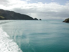 Entrance of Tory Channel / Kura Te Au | |
 Tory Channel / Kura Te Au Tory Channel / Kura Te Au | |
| Location | Marlborough Region, New Zealand |
| Coordinates | 41°14′24″S 174°14′00″E / 41.24000°S 174.23333°ECoordinates: 41°14′24″S 174°14′00″E / 41.24000°S 174.23333°E |
| Type | Ria |
| Native name | Kura Te Au (Māori) |
| Part of | Marlborough Sounds |
| Max. length | 16.8 kilometres (10.4 mi) |
| Max. width | 1.1 kilometres (0.68 mi) |
| Average depth | 39.2 metres (129 ft) |
| Max. depth | 65 metres (213 ft) |
| Islands | Moioio Island |

Tory Channel / Kura Te Au is one of the drowned valleys that form the Marlborough Sounds in New Zealand. Inter-island ferries normally use it as the principal channel between Cook Strait and the Marlborough Sounds.[1][2]
Tory Channel / Kura Te Au lies to the south of Arapaoa Island, separating it from the mainland. At its western end it joins the larger Queen Charlotte Sound, which it meets halfway along the latter's length. Its eastern end meets Cook Strait close to the strait's narrowest point.[3] The Channel is 16.8 km (10.4 mi) long, averages 1.1 km (0.68 mi) in width, and is up to 65 m (213 ft) deep, with an average channel depth of 39.2 m (129 ft).[4]
Tory Channel / Kura Te Au forms a substantial part of the ferry route between Wellington and Picton. Erosion attributed to the wake from the ferries, particularly the new faster ones (now[when?] discontinued), has resulted in speed restrictions.[5][6]
One of the two candidates for the easternmost point in the South Island (along with Cape Campbell) lies at the entrance of Tory Channel. It is called West Head.
History[]
James Cook anchored several times nearby in Ship Cove. He sighted the Tory Channel in an excursion on the pinnace from his ship HMS Resolution on 5 November 1774. John Guard established the first permanent whaling station on Arapaoa Island in 1827, targeting whales in the Tory Channel for their baleen and whale oil.[7] Tory Channel was accurately surveyed in 1840 and named after the New Zealand Company ship Tory, a pioneer ship that brought British colonists to Wellington. Around this time, whaling stations were already operating in Te Awaiti Bay. Between 1911 and 1964, the Perano family hunted whales from Whekenui Bay. Humpback whales were spotted from the hills at the Tory Channel entrance during their migration through Cook Strait. The Perano Whaling Station was the last whaling operation in New Zealand and closed in 1964.
The name of Tory Channel was officially altered to Tory Channel / Kura Te Au in August 2014.[8]
Tidal power[]
Energy Pacifica planned to install up to ten underwater tidal stream turbines, each able to produce up to 1.2 MW, near the Cook Strait entrance to Tory Channel. They claimed Tory Channel had tidal flows of 3.6 metres per second (12 ft/s) with good bathymetry and access to the electricity network.[9] Other designs envisaged up to 50 turbines, but there are uncertainties about flow rates, the area is about 15 km (9.3 mi) from the HVDC Inter-Island transmission station at Fighting Bay (Ōraumoa) and a calculation in 2013 suggested that an economic return was unlikely.[4]
References[]
- ^ "The Voyage". Interislander. Retrieved 16 December 2014.
- ^ "The journey". Buebridge. Retrieved 16 December 2014.
- ^ "Tory Channel, Marlborough - NZ Topo Map". NZ Topo Map. Land Information New Zealand. Retrieved 16 December 2014.
- ^ a b Plew, David R.; Stevens, Craig L. (1 September 2013). "Numerical modelling of the effect of turbines on currents in a tidal channel – Tory Channel, New Zealand". Renewable Energy. 57: 269–282. doi:10.1016/j.renene.2013.02.001. ISSN 0960-1481.
- ^ "Ecologically Significant Marine Sites in Marlborough". Marlborough District Council & Department of Conservation. Retrieved 16 December 2014.
- ^ "Speed limit on Marlborough Sounds upheld". The New Zealand Herald. APN New Zealand Limited. 1 June 2006. Retrieved 16 December 2014.
- ^ Prickett, Nigel (1983). "AN ARCHAEOLOGICAL RECONNAISSANCE OF THE SHORE WHALING INDUSTRY ON KAPITI ISLAND, NEW ZEALAND". Records of the Auckland Institute and Museum. 20: 41–63. ISSN 0067-0464.
- ^ "NZGB decisions". Land Information New Zealand. August 2014. Archived from the original on 21 November 2015. Retrieved 6 November 2015.
- ^ Benign tides Energy NZ No.6, Spring 2008. Contrafed Publishing.
This Marlborough Region-related geography article is a stub. You can help Wikipedia by . |
- Landforms of the Marlborough Region
- Straits of New Zealand
- Sounds of the Marlborough Sounds
- Cook Strait Ferry
- Marlborough Region geography stubs