D'Urville Island
Native name: Rangitoto ki te Tonga (Māori) | |
|---|---|
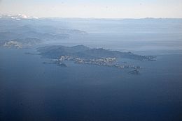 D'Urville Island and Tasman Bay | |
 Location of D'Urville Island | |
| Geography | |
| Coordinates | 40°50′S 173°52′E / 40.833°S 173.867°E |
| Area | 150 km2 (58 sq mi) |
| Highest elevation | 729 m (2392 ft)[1] |
| Highest point | Attempt Hill[2] |
| Administration | |
| Demographics | |
| Population | 52 |

Rangitoto ki te Tonga / D'Urville Island (/dɜːrˈvɪl/) (Rangitoto ki te Tonga, lit. "red heavens look to the south", is the Te Reo Māori name) is an island in the Marlborough Sounds along the northern coast of the South Island of New Zealand. It was named after the French explorer Jules Dumont d'Urville. With an area of approximately 150 square kilometres (58 sq mi), it is the eighth-largest island of New Zealand, and has around 52 permanent residents.[3] The local authority is the Marlborough District Council.
History[]
The official name of the island is Rangitoto ki te Tonga / D'Urville Island, with the Māori language name, associated with Kupe, meaning "Red Heavens Look to the South".[4] The island was a traditional source of argillite (pakohe), used in the production of stone tools such as adzes during the Archaic period (1300–1500).[5][6] From the 1600s until the early 1800s, the island was a part of the rohe of Ngāti Tūmatakōkiri.[7] In the present day, the island is within the rohe of Ngāti Koata and Ngāti Kuia.
Geography[]
The island has a convoluted coastline, as is frequently found with islands formed from peaks between sea-drowned valleys. It extends for some 35 kilometres (22 miles) northeast/southwest, and is a little over 10 kilometres (6.2 miles) wide at its widest point. The eastern coast of the island is relatively smooth, marked mainly by the small D'Urville Peninsula, some halfway along its length. In contrast, the west coast is marked by three large inlets: Port Hardy in the north, Greville Harbour in the centre, and Manuhakapakapa in the south. Numerous smaller islands lie off the coast, notably Stephens Island, which lies 3 kilometres (1.9 miles) off D'Urville's northernmost point, Cape Stephens. The island's highest point, Takapōtaka / Attempt Hill (729 metres or 2,392 feet) lies close to the centre of the island, due east of Greville Harbour. Most of the island's residents live close to the more sheltered east coast, with the localities of Patuki and Mukahanga being close to the northern tip of the island.[8]
French Pass[]
The island is separated from the mainland by the dangerous French Pass, known to Māori as Te Aumiti, through which water passes at up to 8 knots (15 km/h; 9 mph) at each tide. Several vortices occur near this passage. d'Urville investigated the passage for several days in 1827, and damaged his ship passing through it.[3]
Coordinates: 40°50′S 173°52′E / 40.833°S 173.867°E
Transport[]
Air[]
A small Department of Conservation maintained airstrip is located at , . Pelorus Air has flights to D'Urville Island from Picton, Wellington and Paraparaumu.[9]
Boat[]
A barge service is operated by D'Urville Island Crossings between French Pass village and the settlement of . There is also a water taxi operating between the D’Urville Island Wilderness Resort at and French Pass.
In 2016, Motueka based Abel Tasman Sea Shuttles hosted a number of charity cruises around D'Urville Island in conjunction with the Rotary Club of Motueka.[10]
Tours[]
Driftwood Eco Tours [1] take small group tours to D'Urville Island. The tours focus on the heritage and ecology of the island, meeting with local residents to learn about the island's unique features. Driftwood Eco Tours donate each year to 'DISECT' (D'Urville Island Stoat Eradication Trust).
See also[]
- Islands of New Zealand
- List of places named after people
References[]
- ^ "Attempt Hill, Marlborough – NZ Topo Map". Land Information New Zealand. Retrieved 17 October 2017.
- ^ "Western Sounds".
- ^ a b Gerard Hindmarsh (2006). "Discovering D'Urville". Heritage New Zealand. Archived from the original on 11 May 2011. Retrieved 13 January 2011.
- ^ "Place name detail: Rangitoto ki te Tonga / D'Urville Island". New Zealand Gazetteer. New Zealand Geographic Board. Retrieved 2 August 2019.
- ^ Johnston, Mike (2011). "Pakohe – A Rock that sustained early Maori Society in New Zealand". In Ortiz, J. E.; Puche, O.; Rábano, I.; Mazadiego, L. F. (eds.). History of Research in Mineral Resources. Cuadernos del Museo Geominero. Vol. 13. Instituto Geológico y Minero de España. pp. 61–74. ISBN 978-84-7840-856-6.
- ^ Furey, Louise (2014). "Adzes with notches". Records of the Auckland Museum. 49: 5–13. ISSN 1174-9202. Retrieved 14 January 2021.
- ^ Mitchell, John; Mitchell, Hilary (April 2020). "Ngāti Tūmatakōkiri". The Prow: Ngā Kōrero o te Tau Ihu. Retrieved 18 September 2021.
- ^ Reed New Zealand atlas (2004) Auckland: Reed Publishing. Map 61 ISBN 0790009528
- ^ "Flight Prices".
- ^ "Archived copy". Archived from the original on 6 August 2016. Retrieved 10 July 2016.
{{cite web}}: CS1 maint: archived copy as title (link)
External links[]
| Wikimedia Commons has media related to D'Urville Island, New Zealand. |
- Islands of the Marlborough Sounds
- Populated places in the Marlborough Sounds