Trams in Düsseldorf
| Düsseldorf tramway network | |||||||||||||||||||||||
|---|---|---|---|---|---|---|---|---|---|---|---|---|---|---|---|---|---|---|---|---|---|---|---|
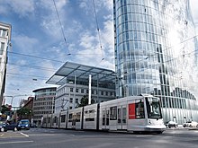 A Düsseldorf tram at . | |||||||||||||||||||||||
| Operation | |||||||||||||||||||||||
| Locale | Düsseldorf, North Rhine-Westphalia, Germany | ||||||||||||||||||||||
| |||||||||||||||||||||||
| |||||||||||||||||||||||

The Düsseldorf tramway network (German: Straßenbahnnetz Düsseldorf) is a network of tramways serving Düsseldorf, the capital city of the federal state of North Rhine-Westphalia, Germany. In combination with the Düsseldorf Stadtbahn and Rhine-Ruhr S-Bahn, it forms the backbone of the public transport system in Düsseldorf.
The tramway network is currently operated by Rheinbahn AG, and is integrated in the Verkehrsverbund Rhein-Ruhr (VRR). As of 2016, its seven tram lines ran over 78.0 kilometres (48.5 mi) of route, serving 178 stops.[1]
History[]

In 1876, the first horse-drawn tram line opened in Düsseldorf operated by the Belgian entrepreneur . It joined Castle Square with the Bergisch-Märkischen station and the concert hall.[2]
In 1896, the first electric tram ran in Düsseldorf,[2] and the full conversion of the system to electricity continued through 1900.[2]
Lines[]
As of 2016, seven tram lines[1] running on 78.0 kilometres (48.5 mi) of route,[1] operate in the city of Düsseldorf and in portions of the urban areas of Neuss:
| Line | Route | Stops | Run time | Takt Mo.–Fr./Sa./Su. |
|---|---|---|---|---|
| 701 | (ISS Dome (under construction)) – |
28 | 35 min | 10/10/15 (20/20/30) |
| 704 | Merziger Straße – Straßburger Straße – Alter Schlachthof – Rather Straße / Hochschule HSD – St.-Vinzenz-Krankenhaus – Lennéstraße – Stockkampstraße – Rochusmarkt – Adlerstraße – |
21 | 29 min bis Uni Nord / 30 min bis Botanischer Garten | 10/15/15 (-/-/15) |
| 705 | |
32 | 43 min | 10/10/15 (20/20/30) |
| 706 | |
35 | 51 min | 10/15/15 |
| 707 | |
29 | 43 min | 10/10/15 |
| 708 | Heinrichstraße – Hansaplatz – Grunerstraße – Brehmplatz – Schillerplatz – Uhlandstraße – Birkenstraße – Worringer Platz – Hauptbahnhof |
15 | 23 min | 20/-/- |
| 709 | Gerresheim, Krankenhaus – Heinrich-Könn-Straße – Auf der Hardt / LVR-Klinikum – Pöhlenweg – (Grafenberg, Staufenplatz) – Burgmüllerstraße – Schlüterstraße / Arbeitsagentur – Engerstraße – Hoffeldstraße – |
33 | 54 min | 10/10/15 (20/20/30) |
After finishing work at the Wehrhahlinie, many of the tram lines (703, 712, 713 and 715) have been moved to the new Stadtbahn service.
Rolling stock[]
The current tram fleet consists of low-floor trams which are good for wheelchair accessibility.
See also[]
- Düsseldorf Stadtbahn
- Rhine-Ruhr S-Bahn
- Rhein-Ruhr Stadtbahn
- Verkehrsverbund Rhein-Ruhr
- List of town tramway systems in Germany
- Trams in Germany
References[]
Notes[]
- ^ Jump up to: a b c d e f "Zahlenübersicht Stand 31. Dezember 2012" [Figures Summary as of December 31, 2012] (PDF) (in German). Rheinbahn. December 31, 2012. p. 7. Retrieved 2013-10-19.
- ^ Jump up to: a b c "1920: Das Ende der Düsseldorfer Straßenbahn" [1920: The end of the Düsseldorf tram [company]] (in German). Rheinbahn. Retrieved 2013-10-19.
Bibliography[]
- Höltge, Dieter (1994). Straßen- und Stadtbahnen in Deutschland [Tramways and Stadtbahnen in Germany] (in German). Band 4: Ruhrgebiet - Von Dortmund bis Duisburg [Volume 4: Ruhr - from Dortmund to Duisburg]. Freiburg i. B., Germany: EK-Verlag. ISBN 9783882553345.
- Nolden, Hans G (1998). Die Düsseldorfer Straßenbahn [The Düsseldorf Tramway] (in German). München: GeraMond Verlag. ISBN 3932785029.
- Schwandl, Robert (2012). Schwandl's Tram Atlas Deutschland (in German and English) (3rd ed.). Berlin: Robert Schwandl Verlag. pp. 46–48. ISBN 9783936573336.
External links[]
| Wikimedia Commons has media related to Trams in Düsseldorf. |
- Rheinbahn - official site (in German)
- Rheinbahn - official site
- Düsseldorf network map (pdf)
- Düsseldorf database / photo gallery and Düsseldorf tram list at Urban Electric Transit – in various languages, including English.
- Düsseldorf database / photo gallery at Phototrans – in various languages, including English.

| show Urban public transport networks and systems in Germany |
|---|


- Tram transport in Germany
- Transport in Düsseldorf
- Town tramway systems by city