Trams in Augsburg
| Augsburg tramway network | ||||||||||||||||||||||||||
|---|---|---|---|---|---|---|---|---|---|---|---|---|---|---|---|---|---|---|---|---|---|---|---|---|---|---|
 A Siemens Combino in Augsburg, 2007. | ||||||||||||||||||||||||||
| Operation | ||||||||||||||||||||||||||
| Locale | Augsburg, Bavaria, Germany | |||||||||||||||||||||||||
| ||||||||||||||||||||||||||
| ||||||||||||||||||||||||||
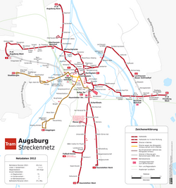
The tram system in Augsburg is the second largest tram system in Bavaria, behind Munich and before Nurnberg. The system is 45.4 kilometers long (28.2 miles) and runs five lines, with two special lines. The city border gets crossed in three places. Line 2 and Line 3 cross into Stadtbergen, and line 6 crosses into Friedberg. The line first opened in early May 1881, with horse-drawn trams. In 1881, there was an average of 61 million yearly passengers.[1] In 1972, the trams were electric with overhead powerlines. The system is operated by (SWA), and integrated into the Augsburger Verkehrs- und Tarifverbund (AVV).
Lines[]
As of 2019, the network has five regular lines and two special lines, as follows:
| Regular line | Cross-city route | Lechhausen Neuer Ostfriedhof – Berliner Allee – Königsplatz – Bergstraße – Göggingen | 26 stops | |
| Regular line | Cross-city route | Augsburg West P+R – Oberhausen Bf / Helmut-Haller-Platz – Dom / Stadtwerke – Königsplatz – Haunstetter Straße Bf – Sportanlage Süd P+R – Haunstetten Nord | 27 stops | |
| Regular line | Cross-city route | Stadtbergen – Pfersee – Hauptbahnhof – Königsplatz – Haunstetter Straße Bf – Universität – Innovationspark/LfU – Haunstetten West P+R | 26 stops | |
| Regular line | Radial route | Hauptbahnhof – Königsplatz – Curt-Frenzel-Stadion – Plärrer P+R – Bärenwirt / DRvS – Augsburg Nord P+R | 12 stops | |
| Regular line | Radial route | Hauptbahnhof – Königsplatz – Hochschule Augsburg – Schwaben Center – Rudolf-Diesel-Gymnasium – Friedberg West P+R | 15 stops | |
| Special line | Radial route | Hauptbahnhof – Königsplatz – Haunstetter Straße Bf – Universität – Innovationspark/LfU – Fußball-Arena | 13 stops | |
| Special line | Radial route | Hauptbahnhof – Messezentrum | 9 stops |
Special Lines[]
The two special lines are lines 8 and 9. Line 8 is the line that goes from the main train station (Hauptbahnhof) to the soccer stadium (Fußball-Arena). This line only runs if there is a soccer game occurring.[2] Line 9 is the line that goes from the main train station (Hauptbahnhof) to the Exhibition Center (Messezentrum). This line only runs if there is an exhibition occurring.[2]
Rolling stock[]
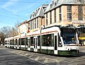
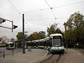
As of 2019, the fleet of the Augsburg tram network consists of three MAN M8C trams, 11 ADtranz GT6M trams, 41 Siemens Combino type NF8, and 27 Bombardier Flexity type Cityflex CF8 trams.[3] Stadler is supplying 11 new Tramlink units as a replacement for the M8C and GT6M trams. Entry into service is scheduled for 2022.[3]
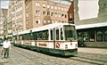
MAN M8C

ADtranz GT6M
Siemens Combino NF8
Bombardier Flexity Cityflex CF8


- The MAN M8C trams are mainly are on line 1 and sometimes line 2, and there are about 3 of them.
- The ADtranz GT6M trams are mainly are on line 6.
- The Siemens Combino NF8 trams are mainly on line 3
- The Bombardier Flexity "Cityflex" trams are mainly on lines 1, 2, and 4, as well as about 20 on line 3
Timetable[]
On a normal week day, the trams run every five minutes from 05:00-11:00 and from 14:00-21:00. on a normal work day, the tram runs every seven and a half minutes while people are at work and school. This is from 11:00-14:00. On a normal work day, from 21:00-0:00, the trams run every fifteen minutes. On a normal Saturday, the trams run every 10 minutes. On a normal Sunday, the trams run every fifteen minutes. On a holiday on any day the trams run every fifteen minutes. During a school break, the trams run every seven and a half minutes. Trams operate from 05:00-0:00.
Planned Changes[]
Line 3[]
Line 3 is being expanded to add 6 more stops from Haunstetten West P+R to Königsbrunn, in 2021.[4]
| Stops |
|---|
| Haunstetten West P+R |
| Schulzentrum |
| Brahmsstraße |
| Bereitschaftspolizei |
| Guldenstraße |
| Brunnen Zentrum |
| Mindelheimer Straße |
| Königsbrunn Zentrum |
Line 5[]
Line 5 does not exist yet and is still in the planning phase. The line is supposed to start from the main train station (Hauptbahnhof), to the University Hospital (Uniklinik).[5]
See also[]
References[]
Notes[]
- ^ DVV Media Group GmbH, "Augsburg: Fahrgastzahl steigt deutlich auf mehr als 60 Mio", Bus & Bahn (in German), retrieved 2017-04-04
- ^ Jump up to: a b name=Netz
- ^ Jump up to: a b "Stadler gewinnt Ausschreibung über elf Straßenbahnen für die Stadtwerke Augsburg" [Stadler wins tender for eleven trams from Stadtwerke Augsburg]. Urban Transport Magazine (in German). October 3, 2019. Archived from the original on October 3, 2019. Retrieved October 3, 2019.
- ^ https://www.linie-3.de/von-koe-zum-koe.html
- ^ https://www.projekt-augsburg-city.de/linie-5/linie-5-vision/
Bibliography[]
- Höltge, Dieter; Kochems, Michael (2006). Straßen- und Stadtbahnen in Deutschland [Tramways and Stadtbahnen in Germany]. Band 10: Bayern [Volume 10: Bavaria]. Freiburg i. B., Germany: EK-Verlag. ISBN 388255391X. (in German)
- Sappel, Albrecht (1981). Einmal Königsplatz und zurück! 100 Jahre Stadtverkehr in Augsburg [To Königsplatz and Back! One Hundred Years of City Transport in Augsburg] (in German). Düsseldorf: Alba Publikation. ISBN 3-87094-325-4.
- Schwandl, Robert (2012). Schwandl's Tram Atlas Deutschland (in German and English) (3rd ed.). Berlin: Robert Schwandl Verlag. pp. 6–7. ISBN 9783936573336.
- Waßner, Herbert (1998). 100 Jahre Augsburger Nahverkehrsfahrzeuge im Bild [One Hundred Years of Augsburg Local Transport Vehicles in Pictures] (in German). Augsburg: F.d.A.S.
- Rückblick auf 20 Jahre "Freunde der Augsburger Straßenbahn" [Review of 20 Years of the "Friends of the Augsburg Tramway"] (in German). Freunde der Augsburger Straßenbahn. 2009.
External links[]
 Media related to Trams in Augsburg at Wikimedia Commons
- Track plan of the Augsburg tram system
- Augsburg database / photo gallery and Augsburg tram list at Urban Electric Transit – in various languages, including English.
- Augsburg database / photo gallery at Phototrans – in various languages, including English.

| show Urban public transport networks and systems in Germany |
|---|


Coordinates: 48°21′26″N 10°54′23″E / 48.35722°N 10.90639°E

- Transport in Augsburg
- Tram transport in Germany
- Metre gauge railways in Germany
- 600 V DC railway electrification
- Town tramway systems by city