Typhoon Joan (1970)
| Category 5 super typhoon (SSHWS) | |
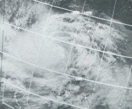 Super Typhoon Joan was the largest typhoon in size during the 1970 season.[1] This image shows the size of the storm. | |
| Formed | October 10, 1970 |
|---|---|
| Dissipated | October 18, 1970 |
| Highest winds | 1-minute sustained: 280 km/h (175 mph) |
| Lowest pressure | 905 hPa (mbar); 26.72 inHg |
| Fatalities | 768 direct (includes 193 unaccounted for) |
| Damage | $74 million (1970 USD) |
| Areas affected | Ulithi Atoll of the Caroline Islands, Philippines, Hainan Island and Southeastern People's Republic of China Hong Kong |
| Part of the 1970 Pacific typhoon season | |
Super Typhoon Joan, known in the Philippines as Typhoon Sening,[2] was the first of two super typhoons to strike the Philippines within a week in October 1970, the second being Super Typhoon Kate. Super Typhoon Joan is the fourth strongest typhoon[3] ever to affect the Philippines, just after typhoons Haiyan, Meranti, and Goni.
Meteorological history[]

Tropical storm (39–73 mph, 63–118 km/h)
Category 1 (74–95 mph, 119–153 km/h)
Category 2 (96–110 mph, 154–177 km/h)
Category 3 (111–129 mph, 178–208 km/h)
Category 4 (130–156 mph, 209–251 km/h)
Category 5 (≥157 mph, ≥252 km/h)
Unknown
A tropical disturbance was first detected on October 8 near Truk (now Chuuk) and Ponape (now Pohnpei). Due to the wind and sea conditions, the disturbance moved west quicker than expected at near 17 knots (31 km/h or 20 mph). A circulation developed on the morning of October 9,[1] and it was a tropical storm by the time it passed Ulithi Atoll.
Joan continued to strengthen, and by October 11 had become a typhoon. However, it had slowed in forward speed due to it moving near an anticyclone that was located 300 miles (480 km) southeast of Okinawa. As Joan continued to strengthen, it reacted to the ridge line, and turned to the northwest, aiming the storm straight at Bicol Region and specifically Bicol Peninsula of Luzon.[1]
An aerial reconnaissance crew (similar to Hurricane Hunters) sent to investigate Joan on October 13 encountered severe turbulence and a g-force reading of 2.5 gs[1] as the storm was at its peak. The readings sent back put Joan with 150 knot (280 km/h or 175 mph) winds and a minimum central pressure of 905 mb.
The storm made landfall near noon the same day in the Lagonoy Gulf region of Luzon, but not before it had threatened and brushed the coast of Catanduanes Island. Bicol and Tagalog Provinces were affected as the storm continued to move across Luzon, losing strength. On October 14, the storm passed within 20 miles (32 km) of Manila.
Joan then entered the South China Sea. However, its path over Luzon had caused it to lose organisation around the vertical structure of the central eye region of Joan. Over October 14 and 15, the area of gale-force (tropical storm-force) winds grew to a 250-mile (400 km)- (400 km) radius from its centre. Its eye diameter also grew to 80 miles (130 km)[1] - double the average eye diameter. This area filled almost the whole northern South China Sea and made Joan the largest storm of the season in size.
A trough over central China interacted with the ridge line and made Joan turned more northerly, and the storm took aim at the northeastern tip of Hainan Island on October 17. It made landfall on the Luichow Peninsula as a minimal typhoon and dissipated over southern China on October 18.
Impact[]
A United States Coast Guard LORAN station on Catanduanes, 30 miles (50 km) north of where the centre of the storm passed, recorded a windspeed of 90 knots (165 km/h or 105 mph) gusting to 110 knots (205 km/h or 130 mph). In Virac, on the island, the Philippine Weather Bureau station recorded a minimum sea level pressure of 950.7 mb and winds of 150 knots (280 km/h), but was heavily damaged.
Typhoon Joan made a direct hit on Naga City, where many people died from flying debris, collapsing homes, falling trees and floods.[4] By doing so, the storm became the most intense storm ever of the Bicol Region.[5]
Manila International Airport reported a peak gust of 84 knots (156 km/h or 97 mph) and a minimum pressure reading of 976.9 mb, while a U.S. Coast Guard ship, the USCGC Blackhaw anchored in Manila Bay reported a 75-knot (139 km/h) gust.
The storm caused damage bad enough to rank high as some of the most destructive figures ever. Joan left over 80,000 people homeless, in addition to killing 575 people (193 people were unaccounted for, and have since been declared dead, bringing the total toll to 768) and injuring nearly 1600.[1] US$74 million (1970 USD, $373 million 2005 USD) of damage was estimated, along with a 92% loss of agricultural crop in the regions affected. Later that same week, Super Typhoon Kate devastated the Philippines, making conditions worse.
In the South China Sea, shipping traffic was disrupted and USS Agerholm was reportedly in distress for almost 24 hours.[1] However, there is a lack of information about damage and deaths in China.
See also[]
References[]
- ^ a b c d e f g Joint Typhoon Warning Center (1970). "J. Typhoon Joan" (PDF). Archived from the original (PDF) on June 7, 2011. Retrieved August 15, 2017.
- ^ "Story archives, 1963–1988". Retrieved May 25, 2006.
- ^ Dominic Alojado (2004). "Strongest Typhoons Of The Philippines (1947-2002)". Archived from the original on February 7, 2005. Retrieved August 15, 2017.
- ^ Dominic Alojado (2004). "The Ten Worst Typhoons Of The Philippines (1947-2002)". Archived from the original on February 7, 2005. Retrieved August 15, 2017.
- ^ Typhoon2000.ph (2004). "27 Most Intense Typhoons Of Bicol Region, Philippines (1947 - 2004)". Retrieved May 25, 2006.
- 1970 Pacific typhoon season
- Typhoons in the Philippines
- Typhoons in China
- 1970 in China
- 1970 in the Philippines
- Typhoons
- Retired Philippine typhoon names