Urjala
Urjala | |
|---|---|
Municipality | |
| Urjalan kunta Urjala kommun | |
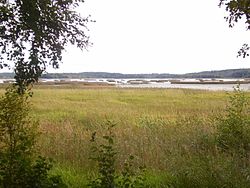 Kortejärvi Lake in Urjala | |
 Coat of arms | |
 Location of Urjala in Finland | |
| Coordinates: 61°05′N 023°33′E / 61.083°N 23.550°ECoordinates: 61°05′N 023°33′E / 61.083°N 23.550°E | |
| Country | |
| Region | Pirkanmaa |
| Sub-region | Southern Pirkanmaa |
| Charter | 1868 |
| Government | |
| • Municipal manager | Hannu Maijala |
| Area (2018-01-01)[1] | |
| • Total | 505.37 km2 (195.12 sq mi) |
| • Land | 475.22 km2 (183.48 sq mi) |
| • Water | 30.16 km2 (11.64 sq mi) |
| Area rank | 182nd largest in Finland |
| Population (2021-03-31)[2] | |
| • Total | 4,651 |
| • Rank | 180th largest in Finland |
| • Density | 9.79/km2 (25.4/sq mi) |
| Population by native language | |
| • Finnish | 98% (official) |
| • Swedish | 0.3% |
| • Others | 1.7% |
| Population by age | |
| • 0 to 14 | 12.9% |
| • 15 to 64 | 54% |
| • 65 or older | 33.1% |
| Time zone | UTC+02:00 (EET) |
| • Summer (DST) | UTC+03:00 (EEST) |
| Municipal tax rate[5] | 22% |
| Website | www.urjala.fi |

Urjala (Swedish: Urjala, also Urdiala) is a municipality of Finland.
It is part of the Pirkanmaa region, near Forssa. The municipality has a population of 4,651 (31 March 2021)[2] and covers an area of 505.37 square kilometres (195.12 sq mi) of which 30.16 km2 (11.64 sq mi) is water.[1] The population density is 9.79 inhabitants per square kilometre (25.4/sq mi).
Neighbouring municipalities are Akaa, Forssa, Humppila, Hämeenlinna, Punkalaidun, Sastamala, Tammela, and Vesilahti.
The municipality is unilingually Finnish.
Villages[]
Annula, Hakkila, Hakolahti, , Harittu, , Huhti, Kamppari, Kehro, Kokko, Laukeela, , , Perho, Puolimatka, Salmi, Tursa, Urjalankylä, Vahonen, Valajärvi, , Välkkilä
Notable individuals[]
- Johan Hampus Furuhjelm, vice-admiral and explorer
- Mimmi Kanervo, one of Finland's first female MPs
- Väinö Linna, author
- , municipal manager for 32 years (1948-1980)
Trivia[]
- Väinö Linna was born in Urjala, although he is most often referred to be from Tampere where he lived most of his adult life.
- The oldest glassblowing factory in Finland is located in the village of Nuutajärvi, Urjala.
Images[]
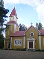
Urjala Church

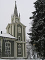
Halkivaha Church
Halkivaha Church
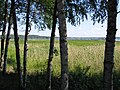
Lake Kortejärvi in Urjala


References[]
- ^ Jump up to: a b "Area of Finnish Municipalities 1.1.2018" (PDF). National Land Survey of Finland. Retrieved 30 January 2018.
- ^ Jump up to: a b "Preliminary population structure by area, 2021M01*-2021M03*". StatFin (in Finnish). Statistics Finland. Retrieved 2 May 2021.
- ^ "Population according to language and the number of foreigners and land area km2 by area as of 31 December 2008". Statistics Finland's PX-Web databases. Statistics Finland. Retrieved 29 March 2009.
- ^ "Population according to age (1-year) and sex by area and the regional division of each statistical reference year, 2003-2020". StatFin. Statistics Finland. Retrieved 2 May 2021.
- ^ "List of municipal and parish tax rates in 2021" (PDF). Tax Administration of Finland. 1 December 2020. Retrieved 10 April 2021.
External links[]
![]() Media related to Urjala at Wikimedia Commons
Media related to Urjala at Wikimedia Commons
- Municipality of Urjala – Official website
- Urjalafoorumi – A discussion forum concerning Urjala

| show Authority control |
|---|
This Western Finland location article is a stub. You can help Wikipedia by . |
- Urjala
- Populated places established in 1868
- Western Finland Province geography stubs