Valkeakoski
Valkeakoski | |
|---|---|
Town | |
| Valkeakosken kaupunki Valkeakoski stad | |
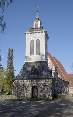 in Valkeakoski | |
 Coat of arms | |
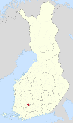 Location of Valkeakoski in Finland | |
| Coordinates: 61°16′N 024°02′E / 61.267°N 24.033°ECoordinates: 61°16′N 024°02′E / 61.267°N 24.033°E | |
| Country | |
| Region | Pirkanmaa |
| Sub-region | Southern Pirkanmaa |
| Charter | 1923 |
| Government | |
| • Town manager | Jukka Varonen |
| Area (2018-01-01)[1] | |
| • Total | 372.03 km2 (143.64 sq mi) |
| • Land | 271.98 km2 (105.01 sq mi) |
| • Water | 100.06 km2 (38.63 sq mi) |
| Area rank | 240th largest in Finland |
| Population (2021-03-31)[2] | |
| • Total | 20,744 |
| • Rank | 51st largest in Finland |
| • Density | 76.27/km2 (197.5/sq mi) |
| Population by native language | |
| • Finnish | 98.1% (official) |
| • Swedish | 0.2% |
| • Others | 1.6% |
| Population by age | |
| • 0 to 14 | 15.5% |
| • 15 to 64 | 56.8% |
| • 65 or older | 27.7% |
| Time zone | UTC+02:00 (EET) |
| • Summer (DST) | UTC+03:00 (EEST) |
| Municipal tax rate[5] | 20.25% |
| Website | www.valkeakoski.fi |

Valkeakoski (Finnish pronunciation: [ˈʋɑlkeɑˌkoski]; lit. "white rapids") is a town and municipality in Finland. It is located 35 kilometres (22 mi) south of Tampere, 45 km (28 mi) north of Hämeenlinna and 150 km (93 mi) north of Helsinki in the Pirkanmaa region. The municipality has a population of 20,744 (31 March 2021)[2] and covers an area of 372.03 square kilometres (143.64 sq mi) of which 100.06 km2 (38.63 sq mi) is water.[1] The population density is 76.27 inhabitants per square kilometre (197.5/sq mi).
The municipality is unilingually Finnish.
Valkeakoski is best known for its paper industry and domestically highly successful football team, FC Haka.
The town and the paper industry have both grown by the Valkeakoski rapids between the lake Mallasvesi in the north and the lake Vanajavesi in the south.
History[]
The Valkeakoski area is known to have been inhabited since the Iron Age. More than a thousand years ago, the ridges on the area served as a foundation of the Rapola fort. In the following Middle Ages, the mill town Sääksmäki was the center of the area. However, industrialization towards the end of the 19th century increased the importance of what became the contemporary town of Valkeakoski. The channel of Valkeakoski was opened in 1869, and the first paper mill was completed in 1873, marking the beginning of a continuing tradition of the forest industry. The municipality of Sääksmäki, from which the town of Valkeakoski was detached in 1923 was consolidated with Valkeakoski in 1973.[6]
Districts, neighborhoods and villages[]
Countryside and villages[]

The entire countryside of Valkeakoski consists mainly of the former Sääksmäki municipality areas.
- Sääksmäki (consists of Huittula and Ritvala, Kemmola, Mälkiäinen, Haukila, Uskila, Tykölä, Viranmaa, Kasuri / Koivuniemi / Raija, Metsäkansa, Ylenjoki, Konho, Nikkarinhanko / Muti, Rantoo, Yli-Nissi, Kärjenniemi, Vedentaka, Kaapelinkulma, Kannistonmäki, Viuha, Mattila, Vuorentaka, Valto, Paino, Tarttila, Pyörönmaa and Vanhakylä)
Districts[]
There are 25 districts in what is considered the urban area of Valkeaskoki. These districts are further divided into neighborhoods. The districts and neighborhoods of Valkeakoski are:[7]
|
|
In addition, outside of but in the vicinity of these districts lay Vanhakylä and Viuha.
Sports[]
Valkeakoski is notable for the football team FC Haka and also other Haka sections, especially the cross-country skiing section. The "skiing Haka" is one of the most successful skiing teams in Finland. The other major local sports organization Koskenpojat has also been really successful, winning many national championships in aerobic gymnastics.
International relations[]
Twin towns — sister cities[]
Valkeakoski is twinned with:[8]
Notable persons from Valkeakoski[]
- Veikko Hakulinen
- Mika Kallio
- Pentti Linkola
- Iris Sihvonen
- Emil Wikström
- Juhani Peltonen
- Alpo Suhonen
- Antti Muurinen
Notable places and events[]
- National Football Museum
- music festival (freely translated as Workers' Music Event)
- Tehtaan kenttä
References[]
- ^ Jump up to: a b "Area of Finnish Municipalities 1.1.2018" (PDF). National Land Survey of Finland. Retrieved 30 January 2018.
- ^ Jump up to: a b "Preliminary population structure by area, 2021M01*-2021M03*". StatFin (in Finnish). Statistics Finland. Retrieved 2 May 2021.
- ^ "Population according to language and the number of foreigners and land area km2 by area as of 31 December 2008". Statistics Finland's PX-Web databases. Statistics Finland. Retrieved 29 March 2009.
- ^ "Population according to age (1-year) and sex by area and the regional division of each statistical reference year, 2003-2020". StatFin. Statistics Finland. Retrieved 2 May 2021.
- ^ "List of municipal and parish tax rates in 2021" (PDF). Tax Administration of Finland. 1 December 2020. Retrieved 10 April 2021.
- ^ History of Valkeakoski
- ^ "Kaupunginosat". valkeakoski.fi (in Finnish). Valkeakoski. Retrieved 2019-12-30.
- ^ "Ystävyyskaupungit". valkeakoski.fi (in Finnish). Valkeakoski. Retrieved 2019-12-07.
Gallery[]

Tehtaan kenttä – the football stadium in Valkeakoski, Finland, home of the football team FC Haka Valkeakoski

Valtakatu, the main shopping street of Valkeakoski

Downtown Valkeakoski
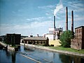
Factories in Valkeakoski


External links[]
![]() Media related to Valkeakoski at Wikimedia Commons
Media related to Valkeakoski at Wikimedia Commons
- Town of Valkeakoski – Official site

| show Authority control |
|---|
- Valkeakoski
- Populated places established in 1923
- 1923 establishments in Finland