Mariehamn
Mariehamn | |
|---|---|
| Mariehamns stad City of Mariehamn | |
        Mariehamn | |
 Coat of arms | |
| Nickname(s): De tusen lindarnas stad (The city of a thousand linden trees)[1] | |
 Location of Mariehamn in Finland | |
 Mariehamn Location within Europe | |
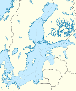
| Coordinates: 60°06′N 019°56′E / 60.100°N 19.933°ECoordinates: 60°06′N 019°56′E / 60.100°N 19.933°E | |
| Country | |
| Region | Åland |
| Sub-region | Mariehamn sub-region |
| Charter | 1861 |
| Named for | Maria Alexandrovna |
| Government | |
| • Mayor | Barbara Heinonen |
| Area (2018-01-01)[2] | |
| • Total | 20.75 km2 (8.01 sq mi) |
| • Land | 11.79 km2 (4.55 sq mi) |
| • Water | 8.96 km2 (3.46 sq mi) |
| Area rank | 311th largest in Finland |
| Population (2021-03-31)[3] | |
| • Total | 11,718 |
| • Rank | 86th largest in Finland |
| • Density | 993.89/km2 (2,574.2/sq mi) |
| Population by native language | |
| • Swedish | 87.7% (official) |
| • Finnish | 5.8% |
| • Others | 6.5% |
| Population by age | |
| • 0 to 14 | 14.2% |
| • 15 to 64 | 60.9% |
| • 65 or older | 24.9% |
| Time zone | UTC+02:00 (EET) |
| • Summer (DST) | UTC+03:00 (EEST) |
| Municipal tax rate[6] | 17.25% |
| Website | www.mariehamn.ax |


Mariehamn (/məˈriːəhɑːmən/,[7] Finland Swedish: [mɑriːeˈhɑmn] (![]() listen); Finnish: Maarianhamina [ˈmɑːriɑnˌhɑminɑ]; Latin: Portus Mariae) is the capital of the Åland Islands, an autonomous territory under Finnish sovereignty. Mariehamn is the seat of the Government and Parliament of Åland, and 40% of the population of Åland live in the city. It is mostly surrounded by Jomala, the second largest municipality in Åland in terms of population; to the east it is bordered by Lemland. Like all of Åland, Mariehamn is unilingually Swedish-speaking and around 88% of the inhabitants speak it as their native language.[4]
listen); Finnish: Maarianhamina [ˈmɑːriɑnˌhɑminɑ]; Latin: Portus Mariae) is the capital of the Åland Islands, an autonomous territory under Finnish sovereignty. Mariehamn is the seat of the Government and Parliament of Åland, and 40% of the population of Åland live in the city. It is mostly surrounded by Jomala, the second largest municipality in Åland in terms of population; to the east it is bordered by Lemland. Like all of Åland, Mariehamn is unilingually Swedish-speaking and around 88% of the inhabitants speak it as their native language.[4]
The theme of the coat of arms of Mariehamn refers to the city's main livelihood, a maritime transport, and the city's parks, which are typically lined with linden trees.[8][9][10][11] The coat of arms was designed by Nils Byman and confirmed in 1951.[12]
Due to its central location in the Baltic Sea, Mariehamn has become a major summer resort town for global tourism; as many as 1.5 million tourists visit there annually.[13][14][15]
History[]
The town was named after the Russian empress Maria Alexandrovna (1824–1880), literally meaning "Marie's Port". Mariehamn was founded in 1861, around the village of , in what was at the time part of the municipality of Jomala. The city has since expanded and incorporated more of Jomala territory. Mariehamn was built according to a very regular scheme which is well-preserved. One of the oldest streets is Södragatan where many wooden houses dating from the 19th century can be seen. Following the First World War, Mariehamn was home to the Mariehamn Grain Fleet.[16]
On November 8, 1963, a devastating plane crash occurred in Mariehamn, in which 22 out of 25 people lost their lives, which made it the second-deadliest aviation accident in the history of Finland.[17]
Transportation[]
Harbours[]
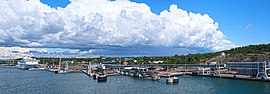
The city is located on a peninsula. It has two important harbours, one located on the western shore and one on the eastern shore, which are ice-free for nearly the whole year, and have no tides.[18] The Western Harbour is an important international harbour with daily traffic to Sweden, Estonia and mainland Finland. A powerful incentive for Baltic ferries to stop at Mariehamn is that, with respect to indirect taxation, Åland is not part of the EU customs zone and so duty-free goods can be sold aboard. Åland and Mariehamn have a reputable heritage in shipping. The Flying P-Liner Pommern museum ship (part of the Åland Maritime Museum) is anchored in the Western Harbour. The Eastern Harbour features one of the largest marinas in Scandinavia. The famous Dutch steamer Jan Nieveen (now called F.P. von Knorring, after Åland teacher and vicar Frans Peter von Knorring) can also be found here.
Airport[]
Mariehamn Airport serves the city; it has scheduled flights on two airlines including Finnair.
Roads[]
At three of Åland's four highways, Mariehamn serves as a starting point for Main Road 1 to Eckerö, Main Road 2 to Sund and Main Road 3 to Lumparland.
Culture[]
The city is an important centre for Åland media; both of the local newspapers (Ålandstidningen and Nya Åland), several radio stations and the local TV channels (TV Åland and Åland24) operate out of the city. The islanders are traditionally fond of reading, and had public libraries before 1920. A printing works was established in the town in 1891.[18] The municipal library, which was built in 1989, is one of the most interesting modern buildings.
Architecture[]
Mariehamn features several buildings drawn by Finnish architect Lars Sonck, who moved to Åland as a child. Buildings drawn by him include the church of Mariehamn (1927), the main building of the (1927) and the town hall (1939). Hilda Hongell also designed several buildings, although only a few are still standing.
Demographics[]
A chart on population increase.[19]
| Year | Population |
|---|---|
| 1987 | 9,966 |
| 1990 | 10,263 |
| 1997 | 10,408 |
| 2000 | 10,488 |
| 2002 | 10,632 |
| 2004 | 10,712 |
| 2006 | 10,824 |
| 2008 | 11,005 |
| 2009 | 11,123 |
| 2010 | 11,190 |
| 2011 | 11,262 |
| 2012 | 11,346 |
| 2013 | 11,393 |
| 2014 | 11,480 |
| 2015 | 11,461 |
| 2016 | 11,565 |
| 2017 | 11,677 |
| 2018 | 11,743 |
| People with a foreign background[20][21] | |
|---|---|
| Country of origin | Population (2017) |
| 1,093 (9.55%) | |
| 173 (1.51%) | |
| 163 (1.42%) | |
| 95 (0.83%) | |
| 92 (0.80%) | |
| 88 (0.77%) | |
| 86 (0.75%) | |
| 73 (0.64%) | |
| 55 (0.48%) | |
| 45 (0.39%) | |
Geography[]
Climate[]
Mariehamn has a transitional climate between humid continental climate (Dfb) with certain maritime (Cfb) influence as a result of the strong maritime moderation from being an island in the Baltic Sea. This renders summers to be cooler than both the Swedish and Finnish mainlands, with winters being similar in cold to the adjacent coastal part of Sweden but milder than Finland's mainland. The lowest temperature at Mariehamn airport was -32.9 C (-27.2F) in February 1979, and the highest temperature on record was 31.3 C (88.3F) in July 1941.[22]
| Climate data for Mariehamn Airport normals 1991-2020, extremes 1914 - present | |||||||||||||
|---|---|---|---|---|---|---|---|---|---|---|---|---|---|
| Month | Jan | Feb | Mar | Apr | May | Jun | Jul | Aug | Sep | Oct | Nov | Dec | Year |
| Record high °C (°F) | 10.9 (51.6) |
10.5 (50.9) |
17.0 (62.6) |
21.1 (70.0) |
27.1 (80.8) |
29.4 (84.9) |
31.3 (88.3) |
30.7 (87.3) |
24.8 (76.6) |
19.0 (66.2) |
16.6 (61.9) |
11.1 (52.0) |
31.3 (88.3) |
| Average high °C (°F) | 1.0 (33.8) |
0.4 (32.7) |
3.1 (37.6) |
8.0 (46.4) |
13.4 (56.1) |
17.5 (63.5) |
20.8 (69.4) |
20.0 (68.0) |
15.5 (59.9) |
9.6 (49.3) |
5.2 (41.4) |
2.5 (36.5) |
9.8 (49.6) |
| Daily mean °C (°F) | −1.3 (29.7) |
−2.3 (27.9) |
−0.2 (31.6) |
3.8 (38.8) |
8.9 (48.0) |
13.3 (55.9) |
16.8 (62.2) |
16.1 (61.0) |
11.8 (53.2) |
6.8 (44.2) |
3.2 (37.8) |
0.4 (32.7) |
6.4 (43.5) |
| Average low °C (°F) | −4.3 (24.3) |
−5.5 (22.1) |
−3.7 (25.3) |
−0.1 (31.8) |
4.0 (39.2) |
8.6 (47.5) |
12.2 (54.0) |
11.6 (52.9) |
7.8 (46.0) |
3.5 (38.3) |
0.6 (33.1) |
−2.5 (27.5) |
2.7 (36.9) |
| Record low °C (°F) | −32.3 (−26.1) |
−32.9 (−27.2) |
−25.0 (−13.0) |
−18.9 (−2.0) |
−6.5 (20.3) |
−3.2 (26.2) |
0.1 (32.2) |
−0.5 (31.1) |
−6.7 (19.9) |
−11.8 (10.8) |
−20.0 (−4.0) |
−28.9 (−20.0) |
−32.9 (−27.2) |
| Average precipitation mm (inches) | 53 (2.1) |
35 (1.4) |
38 (1.5) |
31 (1.2) |
35 (1.4) |
53 (2.1) |
52 (2.0) |
76 (3.0) |
61 (2.4) |
70 (2.8) |
71 (2.8) |
59 (2.3) |
634 (25) |
| Average precipitation days | 17 | 13 | 12 | 9 | 10 | 10 | 9 | 13 | 12 | 16 | 17 | 17 | 155 |
| Mean monthly sunshine hours | 39 | 74 | 130 | 207 | 297 | 296 | 312 | 235 | 163 | 91 | 41 | 26 | 1,911 |
| Source 1: FMI climatological normals for Finland 1991-2020[23] | |||||||||||||
| Source 2: record highs and lows 1961- present[24] | |||||||||||||
Twin towns and sister cities[]
Mariehamn is twinned with:[26]
 Kópavogur, Iceland
 Kragerø, Norway
 Kuressaare, Estonia
 Lomonosov, Russia
 Slagelse, Denmark
 Tórshavn, Faroe Islands
 Valkeakoski, Finland
 Visby, Sweden
Notable persons[]
- Maggie Gripenberg, dancer and choreographer
- Henrik Klingenberg, keyboardist, keytarist and singer of Sonata Arctica
- Anders Överström, professional footballer
- Tommy Wirtanen, semi-professional footballer
Gallery[]

Södragatan, one of the oldest streets of Mariehamn.

.

Ålandsvägen, a typical street in Mariehamn, with linden trees.

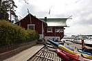
The museum ship Pommern is anchored in the western of Mariehamn's two harbours, Västerhamn.

Nordea bank office in Mariehamn.

Municipal library of Mariehamn.


See also[]
- Fredrikshamn
References[]
- ^ "Turism - Mariehamns stad". Mariehamns stad. Retrieved 23 January 2020.
- ^ "Area of Finnish Municipalities 1.1.2018" (PDF). National Land Survey of Finland. Retrieved 30 January 2018.
- ^ "Preliminary population structure by area, 2021M01*-2021M03*". StatFin (in Finnish). Statistics Finland. Retrieved 2 May 2021.
- ^ a b "Population according to language and the number of foreigners and land area km2 by area as of 31 December 2008". Statistics Finland's PX-Web databases. Statistics Finland. Retrieved 29 March 2009.
- ^ "Population according to age (1-year) and sex by area and the regional division of each statistical reference year, 2003-2020". StatFin. Statistics Finland. Retrieved 2 May 2021.
- ^ "List of municipal and parish tax rates in 2021" (PDF). Tax Administration of Finland. 1 December 2020. Retrieved 10 April 2021.
- ^ "Mariehamn". Merriam-Webster Dictionary. Retrieved December 28, 2020.
- ^ Suomen kunnallisvaakunat (in Finnish). Suomen Kunnallisliitto. 1982. p. 171. ISBN 951-773-085-3.
- ^ "Ahvenanmaan kuntien vaakunat 1947-1987 (I:15) Maarianhamina" (in Swedish). Kansallisarkiston digitaaliarkisto. Retrieved March 25, 2021.
- ^ "Ennen 8.4.1949 annettua kunnanvaakunalakia vahvistetut vaakunat (I:7) Maarianhamina". Kansallisarkiston digitaaliarkisto (in Swedish). Retrieved March 25, 2021.
- ^ "Mariehamns vapen" (in Swedish). City of Mariehamn. Retrieved March 25, 2021.
- ^ Mitä-Missä-Milloin, Kansalaisen vuosikirja 1980 (in Finnish). Helsinki: Otava. 1979. p. 165.
- ^ Mariehamn – Visit Åland
- ^ Tourism Mariehamn & Mariehamn Travel Guide – Discovering Finland
- ^ Åland: many travellers, far fewer overnighters – Nordic Labour Journal
- ^ Derby., W L A (1937). "Mariehamn's Grain Fleet - Shipping Wonders of the World". Shipping Wonders of the World (21 July 1937): 746–749.
- ^ Ranter, Harro. "ASN Aircraft accident Douglas C-47A-35-DL (DC-3) OH-LCA Mariehamn Airport (MHQ)". aviation-safety.net. Aviation Safety Network. Retrieved 2020-07-12.
- ^ a b Prothero, G.W. (1920). The Åland Islands. Great Britain. Foreign Office. Historical Section. p. 5.
- ^ "PX-Web - Select variable and values".
- ^ [1][dead link]
- ^ "Archived copy". Archived from the original on 2018-06-29. Retrieved 2018-09-26.CS1 maint: archived copy as title (link)
- ^ https://helda.helsinki.fi/bitstream/handle/10138/15734/2009nro8.pdf?sequence=1&isAllowed=y
- ^ "FMI normals 1991-2020" (PDF). fmi.fi. Retrieved 26 April 2016.
- ^ "FMI open data". FMI. Retrieved 26 April 2016.
- ^ [2]
- ^ Mariehamns stads vänorter. Accessed July 14, 2015
External links[]
![]() Media related to Mariehamn at Wikimedia Commons
Media related to Mariehamn at Wikimedia Commons
- Official website (in Swedish)
- Official Tourist Gateway of Mariehamn - Maarianhamina
 Mariehamn travel guide from Wikivoyage
- Map of Mariehamn
- Mariehamn. Tourist route (in Russian)
| |||
Authority control | |
|---|---|
| General | |
| National libraries | |
| Other |
|
- Mariehamn
- Cities and towns in Finland
- Populated coastal places in Finland
- Municipalities of Åland
- Grand Duchy of Finland
- Populated places established in 1861
- Port cities and towns of the Baltic Sea
- Seaside resorts in Finland
- 1861 establishments in Finland