Urubamba District
Urubamba Urupampa | |
|---|---|
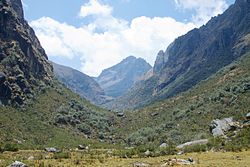 Looking towards Pumawank'a Q'asa | |
| Country | |
| Region | Cusco |
| Province | Urubamba |
| Capital | Urubamba |
| Government | |
| • Mayor | Luis Valcarcel Villegas |
| Area | |
| • Total | 128.28 km2 (49.53 sq mi) |
| Elevation | 2,871 m (9,419 ft) |
| Population (2017) | |
| • Total | 20,082 |
| • Density | 160/km2 (410/sq mi) |
| Time zone | UTC-5 (PET) |
| UBIGEO | 081301 |
Urubamba District is one of seven districts of the province Urubamba in Peru.[1]
Geography[]
The Urupampa mountain range traverses the district. One of highest peaks of the district is Ch'iqun at 5,530 m (18,143 ft). Other mountains are listed below:[2]
- Aqu Q'asa
- Puka Q'asa
- Pumawank'a
- Qhapaq Saya
- Sut'uq
- Taruka Kancha
- T'uruhana
- Uman Urqu
See also[]
References[]
- ^ (in Spanish) Instituto Nacional de Estadística e Informática. Banco de Información Distrital Archived 2008-04-23 at the Wayback Machine. Retrieved April 11, 2008.
- ^ escale.minedu.gob.pe - UGEL map of the Urubamba Province (Cusco Region)
| |
|---|---|
| Acomayo | |
| Anta | |
| Calca | |
| Canas | |
| Canchis | |
| Chumbivilcas | |
| Cusco | |
| Espinar | |
| La Convención | |
| Paruro | |
| Paucartambo | |
| Quispicanchi | |
| Urubamba | |
This Cusco Region geography article is a stub. You can help Wikipedia by . |

Categories:
- Districts of the Urubamba Province
- Cusco Region geography stubs