Pawqar Tampu District, Pawqar Tampu
Pawqar Tampu | |
|---|---|
 Paucartambo | |
| Country | |
| Region | Cusco |
| Province | Paucartambo |
| Capital | Paucartambo |
| Government | |
| • Mayor | Mario Condori Huallpa |
| Area | |
| • Total | 1,079.23 km2 (416.69 sq mi) |
| Elevation | 2,906 m (9,534 ft) |
| Population (2005 census) | |
| • Total | 14,168 |
| • Density | 13/km2 (34/sq mi) |
| Time zone | UTC-5 (PET) |
| UBIGEO | 081101 |
Paucartambo (from Quechua: Pawqar Tampu,[1] meaning "colored tambo") is one of six districts of the Paucartambo Province in Peru.[2]
Geography[]
One of the highest peaks of the district is Yana Urqu at approximately 4,600 m (15,100 ft). Other mountains are listed below:[3]
- Inti Qhawana
- Kunkaq
- K'urkurniyuq
- Llaqta Kancha
- Minasniyuq Urqu
- Misti Pukara
- Pukara Q'asa
- P'allqa Qaqa
- Qullqa
- Quri Pachaq Marka
- Qhispi Qhispiyuq
- Q'illu Mayu
- Ruq'u
- Saywa Punta
- Saywa Urqu
- Suni Urqu
- Waman Qaqa
- Wañuy Marka
- Wayna Urqu
- Wayra Kunka
Ethnic groups[]
The people in the district are mainly indigenous citizens of Quechua descent. Quechua is the language which the majority of the population (86.03%) learnt to speak in childhood, 13.71% of the residents started speaking using the Spanish language (2007 Peru Census).[4]
Culture[]
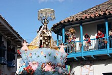
The people of the district have an annual festival in honor of their patron saint, Mamacha Carmen. The Virgin Mary is carried in procession through the streets, preceded and followed by traditional dancers of several types, and many festival goers. Traditional dances of the festival include Chukchu, Ch'unchu, Qhapaq negro, Qhapaq Qulla and Saqra.
Subdistricts[]
- Karaikallo (Karaikallo)
- Paucartambo ()
Cantons[]
- Karaikallo (Karaikallo)
- Paucartambo (Paucartambo)
- Osorio (Osorio)
References[]
- ^ Nonato Rufino Chuquimamani Valer, Carmen Gladis Alosilla Morales, Victoria Choque Valer: Qullaw Qichwapa Simi Qullqan. Lima, 2014 Archived 2014-11-29 at the Wayback Machine
- ^ (in Spanish) Instituto Nacional de Estadística e Informática. Banco de Información Distrital Archived 2008-04-23 at the Wayback Machine. Retrieved April 11, 2008.
- ^ escale.minedu.gob.pe/ UGEL map Paucartambo Province (Cusco Region)
- ^ inei.gob.pe Archived 2013-01-27 at the Wayback Machine INEI, Peru, Censos Nacionales 2007, Frequencias: Preguntas de Población: Idioma o lengua con el que aprendió hablar (in Spanish)
| |
|---|---|
| Acomayo | |
| Anta | |
| Calca | |
| Canas | |
| Canchis | |
| Chumbivilcas | |
| Cusco | |
| Espinar | |
| La Convención | |
| Paruro | |
| Paucartambo | |
| Quispicanchi | |
| Urubamba | |
This Cusco Region geography article is a stub. You can help Wikipedia by . |

- Districts of the Paucartambo Province
- Cusco Region geography stubs