Valdoie
Valdoie | |
|---|---|
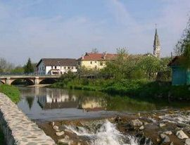 A view of the bridge crossing the river and the church tower, visible at the bottom right | |
 Coat of arms | |
show Location of Valdoie | |
 Valdoie | |
| Coordinates: 47°40′02″N 6°50′31″E / 47.6672°N 6.8419°ECoordinates: 47°40′02″N 6°50′31″E / 47.6672°N 6.8419°E | |
| Country | France |
| Region | Bourgogne-Franche-Comté |
| Department | Territoire de Belfort |
| Arrondissement | Belfort |
| Canton | Valdoie |
| Intercommunality | Grand Belfort |
| Government | |
| • Mayor (2020–2026) | Marie-France Céfis |
| Area 1 | 4.66 km2 (1.80 sq mi) |
| Population (Jan. 2018)[1] | 5,260 |
| • Density | 1,100/km2 (2,900/sq mi) |
| Time zone | UTC+01:00 (CET) |
| • Summer (DST) | UTC+02:00 (CEST) |
| INSEE/Postal code | 90099 /90300 |
| Elevation | 370–438 m (1,214–1,437 ft) |
| 1 French Land Register data, which excludes lakes, ponds, glaciers > 1 km2 (0.386 sq mi or 247 acres) and river estuaries. | |


Valdoie is a commune in the Territoire de Belfort department in Bourgogne-Franche-Comté in northeastern France. It is located to the North of the city of Belfort and comprises part of greater Belfort.
Name[]
Valdoie is situated on the Savoureuse River. The name is thought to have come from combining the Latin word Vadum (meaning shallow crossing) and the Celtic word Oye (meaning water or river).

Valdoie, church (église Saint-Joseph) with war monument
See also[]
| Wikimedia Commons has media related to Valdoie. |
References[]
- ^ "Populations légales 2018". INSEE. 28 December 2020.
This Territoire de Belfort geographical article is a stub. You can help Wikipedia by . |
Categories:
- Communes of the Territoire de Belfort
- Territoire de Belfort geography stubs