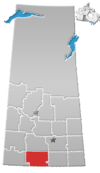
Vanguard, Saskatchewan
Vanguard | |
|---|---|
Village | |
 Monument at entrance to town | |
| Motto(s): A Proud Past & A Promising Future | |
 Vanguard | |
| Coordinates: 49°54′32″N 107°15′25″W / 49.909°N 107.257°W | |
| Country | Canada |
| Province | Saskatchewan |
| Rural municipality | Whiska Creek No. 106 |
| Post office Founded | N/A |
| Village Incorporated | 1912 |
| Town Incorporated | N/A |
| Government | |
| • Mayor | Allen Kuhlmann |
| • Village Administrator | Sandra Krushelnicki |
| • Governing body | Vanguard Village Council |
| Area | |
| • Total | 1.86 km2 (0.72 sq mi) |
| Population (2001) | |
| • Total | 187 |
| • Density | 100.4/km2 (260/sq mi) |
| Time zone | CST |
| Postal code | S0N 2V0 |
| Area code(s) | 306 |
| Highways | Highway 43 Highway 4 |
| Website | Vanguard, Saskatchewan |
Vanguard (2016 population: 134) is a village in the Canadian province of Saskatchewan within the Rural Municipality of Whiska Creek No. 106 and Census Division No. 3. It is on Highway 43 close to . Its prime economic driver is agriculture: chick peas; lentils; red, spring, hard and durum wheats are grown here.
History[]
In 1910, the Canadian Pacific Railway purchased the land from Latimer Young which became the community of Vanguard. Vanguard incorporated as a village on July 8, 1912.[1] The origin of the name Vanguard may be attributed to it having been on the vanguard of the railway in 1912; however, Vanguard is also a name in the Royal Navy tradition. Lord Horatio Nelson had a Vanguard; the last dreadnought battleship (scrapped in 1960) was also called Vanguard. Recent publications state that the inspiration for the name of the village came from HMS Vanguard which was commissioned in 1909 and exploded in 1917, killing 843 of the 845 men aboard. Regardless of the true origin of the name, the north–south streets in Vanguard reflect the naval heritage, being named Armada, Victory, Triumph, Drake and Nelson Streets. The east–west streets are named in honour of the province (Saskatchewan Avenue), the landscape in which Vanguard is situated (Prairie Avenue), the rail heritage (Railway Avenue) and the hopeful spirit in which Vanguard was established (Progress Avenue). Vanguard is bisected by Division St. and the main street is called "Dominion".
Demographics[]
In the 2016 Census of Population conducted by Statistics Canada, the Village of Vanguard recorded a population of 134 living in 64 of its 86 total private dwellings, a -13.4% change from its 2011 population of 152. With a land area of 1.86 km2 (0.72 sq mi), it had a population density of 72.0/km2 (186.6/sq mi) in 2016.[4]
In the 2011 Census of Population, the Village of Vanguard recorded a population of 152, a 0% change from its 2006 population of 152. With a land area of 1.86 km2 (0.72 sq mi), it had a population density of 81.7/km2 (211.7/sq mi) in 2011.[5]
Attractions[]
Nearby communities are Pambrun (home of Millar College of the Bible), Gravelbourg (renowned for its French heritage and cathedral), Swift Current (the regional "headquarters"), Hodgeville ("home" of the Saskatchewan flag) and Ponteix (close to Notekeu Regional Park). Vanguard is close to Cypress Hills inter-provincial park, Grasslands National Park, the Canada–US border, and Lac Pelletier regional park.
Education[]
Vanguard is the home of Vanguard Community School with specialist teachers, low student-teacher ratio, and an enrollment of approximately 90.
Notable people[]
Author, broadcaster, and journalist (1900–1974) called Vanguard home. He worked for the New York Herald Tribune and was the Washington correspondent for the CBC. Knowlton Nash described Mr. Minifie as: "a man passionately dedicated to improving the quality of journalism [whose] overwhelming desire was accuracy in reporting". Woodrow Lloyd, former premier of Saskatchewan, was a principal in Vanguard. NHL goaltender, Al Rollins, was born in Vanguard.
See also[]
- List of communities in Saskatchewan
References[]
- ^ "Urban Municipality Incorporations". Saskatchewan Ministry of Government Relations. Archived from the original on October 15, 2014. Retrieved June 1, 2020.
- ^ "Saskatchewan Census Population" (PDF). Saskatchewan Bureau of Statistics. Archived from the original (PDF) on September 24, 2015. Retrieved May 31, 2020.
- ^ "Saskatchewan Census Population". Saskatchewan Bureau of Statistics. Retrieved May 31, 2020.
- ^ "Population and dwelling counts, for Canada, provinces and territories, and census subdivisions (municipalities), 2016 and 2011 censuses – 100% data (Saskatchewan)". Statistics Canada. February 8, 2017. Retrieved May 30, 2020.
- ^ "Population and dwelling counts, for Canada, provinces and territories, and census subdivisions (municipalities), 2011 and 2006 censuses (Saskatchewan)". Statistics Canada. June 3, 2019. Retrieved May 30, 2020.
Coordinates: 49°54′32″N 107°15′25″W / 49.909°N 107.257°W
- Villages in Saskatchewan
- Whiska Creek No. 106, Saskatchewan
- Division No. 3, Saskatchewan
- Saskatchewan Division No. 3 geography stubs


