Vyšší Brod
Vyšší Brod | |
|---|---|
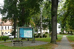 The square in Vyšší Brod | |
 Flag  Coat of arms | |
 Vyšší Brod Location in the Czech Republic | |
| Coordinates: 48°36′58″N 14°18′43″E / 48.61611°N 14.31194°ECoordinates: 48°36′58″N 14°18′43″E / 48.61611°N 14.31194°E | |
| Country | |
| Region | South Bohemian |
| District | Český Krumlov |
| First mentioned | 1259 |
| Government | |
| • Mayor | Milan Zálešák |
| Area | |
| • Total | 69.75 km2 (26.93 sq mi) |
| Elevation | 571 m (1,873 ft) |
| Population (2021-01-01)[1] | |
| • Total | 2,621 |
| • Density | 38/km2 (97/sq mi) |
| Time zone | UTC+1 (CET) |
| • Summer (DST) | UTC+2 (CEST) |
| Postal code | 382 73 |
| Website | www |

Vyšší Brod (Czech pronunciation: [ˈvɪʃiː ˈbrot]; German: Hohenfurth) is a town in Český Krumlov District in the South Bohemian Region of the Czech Republic. It has about 2,600 inhabitants. It is the southernmost municipality in the Czech Republic. Vyšší Brod Monastery, an important historic landmark, is located in the town. The town centre with the monastery complex is well preserved and is protected by law as an urban monument zone.
Administrative parts[]
Villages of Dolní Drkolná, Dolní Jílovice, Herbertov, Hrudkov, Lachovice, Studánky and Těchoraz are administrative parts of Všemyslice.
Geography[]
Vyšší Brod lies on the Vltava river. Watercourses Menší Vltavice and Větší Vltavice flow into the Vltava in Vyšší Brod. The Lipno II Reservoir is located by the town and fed by the Vltava.
The highest point of the municipal territory is the mountain Jezevčí vrch with an altitude of 984 metres (3,228 ft).
History[]

Vyšší Brod was founded on an old trade route near a ford (Czech: brod) across the Vltava, hence the name. The first written mention of the settlement is from 1259 in the deed of foundation of Cistercian monastery, where Vok I. of Rosenberg confirms the donation of a large area for the benefit of this monastery and mentions the market settlement of Vyšší Brod and the church. The settlement was probably founded much earlier.[2]
In 1870, Vyšší Brod was promoted to a town by Emperor Franz Joseph I. After 1918, the coexistence of the German-speaking majority and the Czech minority stabilized. After the World War II, most of the ethnic German population was expelled and was resettled by mostly non-native population. The Iron Curtain was established and the monastery was forcibly abolished.[2]
After the opening of borders in 1989, the town's importance strongly grew due to the direct road to the border crossing at Studánky / Bad Leonfelden.[2] In 1990 the monks returned to the monastery.[3]
Sights[]

The Cistercian Vyšší Brod Monastery with its Church of the Assumption of the Virgin Mary is the most important building and the main landmark of the town. The monastery complex also houses a postal museum.
Other sights include the parish Church of Saint Bartholomew on the town square and the Marian pilgrimage site in Loučovice with Chapel of Maria Rast. The way to the chapel is lined by Stations of the Cross.
Notable people[]
- Leopold Wackarž (1810–1901), Cistercian abbot general, died here
- Franz Isidor Proschko (1816–1891), Austrian writer
Trivia[]
The asteroid no. 121089, which was discovered in 1999 by Miloš Tichý from the Kleť Observatory, was named after the town.
References[]
- ^ "Population of Municipalities – 1 January 2021". Czech Statistical Office. 2021-04-30.
- ^ Jump up to: a b c "Stručná historie města" (in Czech). Město Vyšší Brod. Retrieved 2021-09-04.
- ^ "Obnova klášterního života po pádu komunismu r. 1989" (in Czech). Vyšší Brod Monastery. Retrieved 2021-09-04.
External links[]
| Wikimedia Commons has media related to Vyšší Brod. |
- Official website (in Czech)
| show Authority control |
|---|
- Cities and towns in the Czech Republic
- Populated places in Český Krumlov District
- Bohemian Forest