Wancheng District
This article needs additional citations for verification. (July 2007) |
Wancheng
宛城区 | |
|---|---|
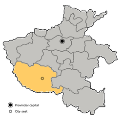
 Wancheng in Nanyang. Note the map does not include the sub-prefecture-level city of Dengzhou. | |
 Nanyang in Henan | |
| Coordinates: 33°00′14″N 112°32′23″E / 33.0038°N 112.5396°ECoordinates: 33°00′14″N 112°32′23″E / 33.0038°N 112.5396°E | |
| Country | People's Republic of China |
| Province | Henan |
| Prefecture-level city | Nanyang |
| Area | |
| • Total | 880 km2 (340 sq mi) |
| Population (2019)[2] | |
| • Total | 938,200 |
| • Density | 1,100/km2 (2,800/sq mi) |
| Time zone | UTC+8 (China Standard) |
| Postal code | 473000 |
| Website | http://www.wancheng.gov.cn/ |

Wancheng District (simplified Chinese: 宛城区; traditional Chinese: 宛城區; pinyin: Wǎnchéng Qū) is one of two districts of the city of Nanyang, in the southwest of Henan province, People's Republic of China.
Administrative divisions[]
As 2012, this district is divided to 6 subdistricts, 4 towns and 6 townships.[3]
- Subdistricts
|
|
- Towns
|
|
- Townships
|
|
Education[]
Higher education[]
- Nanyang Institute of Technology[4](南陽理工學院)
- [5](河南工業職業技術學院)
See also[]
- Expressways of Henan
- China National Highways
- Expressways of China
- Henan
- Wolong District
- Nanyang, Henan
References[]
- ^ 最新人口信息 www.hongheiku.com (in Chinese). hongheiku. Retrieved 2021-01-12.
- ^ 最新人口信息 www.hongheiku.com (in Chinese). hongheiku. Retrieved 2021-01-12.
- ^ 安阳市-行政区划网 www.xzqh.org (in Chinese). XZQH. Retrieved 2012-05-24.
- ^ http://www.nyist.edu.cn/English.htm
- ^ http://www.hnpi.cn/ (Chinese)
This Henan location article is a stub. You can help Wikipedia by . |
Categories:
- Nanyang, Henan
- County-level divisions of Henan
- Henan geography stubs