Xun County
Xun County
浚县 | |
|---|---|
 | |
 Xun County in Hebi | |
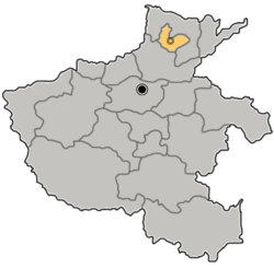 Hebi in Henan | |
| Country | People's Republic of China |
| Province | Henan |
| Prefecture-level city | Hebi |
| Area | |
| • Total | 1,088 km2 (420 sq mi) |
| Population (2019)[2] | |
| • Total | 680,700 |
| • Density | 630/km2 (1,600/sq mi) |
| Time zone | UTC+8 (China Standard) |
| Postal code | 456250 |
| Website | www |
Xun County or Xunxian (simplified Chinese: 浚县; traditional Chinese: 濬縣; pinyin: Xùn Xiàn) is a county in the north of Henan province, China. It is under the administration of the prefecture-level city of Hebi and located on the transition of the East China Plain and the Taihang Mountains.[3]
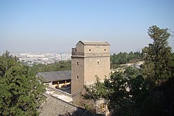
Xun County has a historic center originating to 1331, one of the best preserved of the East China Plain, and is located along the Grand Canal.[4][5][6]
The landscape is characterized by the hills of Dayao and Fuqiu rising from the plains.[6]
The Yellow River historically had its course through the south of the county, causing numerous floods.[3]
History[]
During the Shang dynasty the area was called Li (黎). During the Western Han Dynasty it was first established as a county. In 1115 it was named Xunzhou, governing over Liyang County and Wei County. It was demoted to a county named Xun County in 1369.[6][7][3]
Administrative divisions[]
As 2012, this county is divided to 7 towns and 2 townships.[8]
- Towns
|
- Townships
- (白寺乡)
- (王庄乡)
Notable residents[]
Duanmu Ci was born in Xun County.[6]
References[]
- ^ 最新人口信息 www.hongheiku.com (in Chinese). hongheiku. Retrieved 2021-01-12.
- ^ 最新人口信息 www.hongheiku.com (in Chinese). hongheiku. Retrieved 2021-01-12.
- ^ a b c "浚县(濬縣) - Google Search". www.google.com. Retrieved 2021-05-19.
- ^ 王曉飛. "河南濬縣:因運河而興 打造千年"大運河文化帶"-新華網". m.xinhuanet.com. Retrieved 2021-05-19.
- ^ 馬金章 (2012-06-01). 流經濬縣的大運河 (in Chinese). Beijing Book Co. Inc. ISBN 978-7-5348-3835-4.
- ^ a b c d "濬縣概況". www.xunxian.gov.cn. Retrieved 2021-05-19.
- ^ 中國縣情大全: 華東卷 [Encyclopedia of Chinese Counties: East China Volume] (in Chinese). 中國社會出版社. 1992.
- ^ 鹤壁市-行政区划网 www.xzqh.org (in Chinese). XZQH. Retrieved 2012-05-24.
Coordinates: 35°40′34″N 114°33′00″E / 35.67611°N 114.55000°E

This Henan location article is a stub. You can help Wikipedia by . |
- County-level divisions of Henan
- Henan geography stubs