Wanim Island
Nickname: Grass Island | |
|---|---|
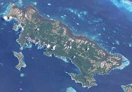 The island of Pana Tinani. Wanim is in the center-left section of the image. | |
 Wanim Island | |
| Geography | |
| Location | Oceania |
| Coordinates | 11°15′48″S 153°15′32″E / 11.26333°S 153.25889°ECoordinates: 11°15′48″S 153°15′32″E / 11.26333°S 153.25889°E[1] |
| Archipelago | Louisiade Archipelago |
| Adjacent bodies of water | Solomon Sea |
| Total islands | 1 |
| Major islands |
|
| Area | 1.66 km2 (0.64 sq mi) |
| Highest elevation | 119 m (390 ft) |
| Highest point | Mount Wanim |
| Administration | |
| Province | |
| District | Samarai-Murua District |
| LLG[2] | Yaleyamba Rural Local Level Government Area |
| Island Group | Pana Tinani Group |
| Largest settlement | (pop. ~450) |
| Demographics | |
| Population | 600 (2014) |
| Pop. density | 361/km2 (935/sq mi) |
| Ethnic groups | Papauans, Austronesians, Melanesians. |
| Additional information | |
| Time zone | |
| ISO code | PG-MBA |
| Official website | www |

Wanim Island is an island in the Louisiade Archipelago in Milne Bay Province, Papua New Guinea.
Geography[]
The island has an area of 3.56 km2, it is part of the Pana Tinani Group. The island is hilly, rising to 119 m at Mt. Wanim. The island is 0.9 km south of Pana Tinani, and separated from it with the .
History[]
The island was discovered in the late 18th century.
Population[]
At the census of population in 2014, the island had 600 inhabitants, spread across 3 small villages. The main town is , located on the northwest point.
References[]
This article about an island in Papua New Guinea is a stub. You can help Wikipedia by . |
Categories:
- Islands of Milne Bay Province
- Louisiade Archipelago
- Papua New Guinea island stubs