Wasatch Front
Wasatch Front | |
|---|---|
 Utah State Capitol, Salt Lake City | |
 Brigham Young University, Provo | |
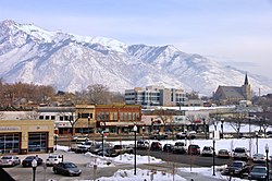 Downtown Ogden | |
| Country | United States |
| State | Utah |
| Population (2018) | 2,606,548 |
The Wasatch Front /ˈwɑːsætʃ/ is a metropolitan region in the north-central part of the U.S. state of Utah. It consists of a chain of contiguous cities and towns stretched along the Wasatch Range from approximately Nephi in the south to Brigham City in the north. Roughly 80% of Utah's population resides in this region, which contains the major cities of Salt Lake City, West Valley City, Provo, West Jordan, Layton, and Ogden.
Geography[]
The Wasatch Front is long and narrow. To the east, the Wasatch Mountains rise abruptly several thousand feet above the valley floors, climbing to their highest elevation of 11,928 feet (3,636 m) at Mount Nebo (bordering southern Utah Valley). The area's western boundary is formed by Utah Lake in Utah County, the Oquirrh Mountains in Salt Lake County, and the Great Salt Lake in northwestern Salt Lake, Davis, Weber, and southeastern Box Elder counties. The combined population of the five Wasatch Front counties totals 2,125,322, according to the 2008 Census Estimate.[1]
Though most residents of the area live between Ogden and Provo (a distance of 80 miles [130 km]), which includes Salt Lake City proper, the fullest built-out extent of the Wasatch Front is 120 miles (190 km) long and an average of 5 miles (8 km) wide. Along its length, the Wasatch Front never exceeds a width of approximately 18 miles (29 km) because of the natural barriers of lakes and mountains.
Climate[]
The Wasatch Front is a semi-arid region at the eastern edge of the Great Basin. The urban corridor mainly lies in zone 7[2] with minimum average winter temperatures ranging between 0 and 20 °F (−18 and −7 °C) and daytime high temperatures ranging from the mid-30 °F to mid-40 °F range (low single-digit Celsius temperatures). Snowfall is common during winter but often melts rapidly. Inversions commonly occur along the Wasatch Front during mid-winter making for very cold temperatures and gloomy conditions lasting for several weeks at times in the valleys, while the higher mountain elevations will experience clear and warmer conditions. Localized lake-effect snowfall from the Great Salt Lake is common in the late Fall and early winter. The first freeze usually occurs in early October in the outlying areas but can occur as late as early November in the inner urban areas. The last freeze can occur broadly between early April and late May.
Summers are generally hot and dry, with the exception of the monsoon season which usually runs from early July through early September when often intense thunderstorms occur. Daytime high temperatures range between 95 and 105 °F (35–41 °C), with higher temperatures often created by the urban heat island effect.[3]
Population centers[]
| Rank | County | 2017 estimate[4] | 2010 Census[5] | Growth % |
|---|---|---|---|---|
| 1 | Salt Lake | 1,106,700 | 1,029,655 | +7.48% |
| 2 | Utah | 576,496 | 516,564 | +11.60% |
| 3 | Davis | 334,977 | 306,479 | +9.30% |
| 4 | Weber | 244,101 | 231,236 | +5.56% |
| 8 | Box Elder | 52,182 | 49,975 | +4.42% |
| Total | 2,314,456 | 2,133,909 | +8.46% | |


Several downtown and commercial districts encompass the Wasatch Front. The largest is Salt Lake City at the middle of the urban area. The Utah Valley, south of the Salt Lake area (Provo and Orem) and the Ogden-Clearfield region (north of Salt Lake) are the other major population centers.
Nearly all of the cities within the region are connected by continuous suburban development. Cumulative population estimates of Brigham City, Weber County, Davis County, Salt Lake County, and Utah County for 2006 show that the Wasatch Front has an estimated population of 2,051,330 residents, or 80% of Utah's estimated 2007 population of 2,645,330 [6]
Transportation[]
Ogden has served as a major railway hub through much of its history. The First Transcontinental Railroad was constructed between 1863 and 1869, the tracks reaching Ogden on March 27, 1869. Trains heading east from Ogden must negotiate the highest reaches of eastern Utah, travelling through Weber and Echo Canyons and over the Wasatch Pass at an elevation of 6,792 feet.
Union Pacific has operated the world's most powerful locomotives to haul freight over the Wasatch Mountains between Cheyenne and Ogden, including American Locomotive Company's famous "Big Boys", the world's largest steam locomotive; GE's Gas Turbines known as the "Big Blows" (because of their distinctive sound), the world's most powerful internal combustion locomotive; and GM's "Big Jacks", the most powerful single-unit diesel locomotive type ever built.
Transportation issues within the metropolitan area have been complicated by the narrow north–south orientation of the valley, constrained by the natural barriers on both sides, and the rapid growth of the region.
The primary modes of transport for the area are Interstate 15 (I‑15) and U.S. Route 89 (US‑89), both of which run down its center from north to south for the full length of about 120 miles (190 km). Other interstates and highways provide transportation routes to local areas within the front. Such transportation routes include Interstate 84 in the Ogden area; the Legacy Parkway (State Route 67) running north–south through western Davis County; Interstate 80 running east–west through Salt Lake City; Interstate 215 (I‑215) circling the inner Salt Lake Valley; the Mountain View Corridor (State Route 85), Bangerter Highway (State Route 154), and State Route 201 to the west of Salt Lake City; U.S. Route 189 through Provo, and U.S. Route 6 in southern Utah County.[7]
The Utah Transit Authority provides bus and light rail (TRAX) service to most of the urban areas within the front. Additionally, a double-decker commuter rail line FrontRunner,[8] running from North Ogden to Provo is in full operation.[9]
The California Zephyr of Amtrak[10] is the primary rail transport leading in and out of the Front, having a station in Salt Lake City and Provo.
Salt Lake City International Airport serves as the primary airport for the region. Ogden-Hinckley Airport and Provo Municipal Airport also provide scheduled commercial air service.

Growth and land use[]
Because of the geographical barriers to the east and west, much of the land along the Wasatch Front has been developed. The region has experienced considerable growth since the 1950s, with its population increasing 308% from 492,374 to 2,051,330. Much of the remaining undeveloped land is rapidly being developed, and local governments have grappled with problems of urban sprawl and other land-use concerns.
The region on the other side of the Wasatch Range, including cities such as Park City, Morgan, Heber City, and Midway is sometimes referred to as the Wasatch Back and has recently shared in the rapid growth of the region.

See also[]
- 2003 Utah snowstorm
- Ogden-Clearfield metropolitan area
- Provo-Orem metropolitan area
- Salt Lake City metropolitan area
- Wasatch Back
- Wasatch Fault
References[]
- ^ ". U.S. Census Bureau. Retrieved on 06-15-2008". Archived from the original on 2004-04-27. Retrieved 2008-07-15.
- ^ "Utah Planting Zones". Gilmour.
- ^ "Utah Weather". Visit Utah.
- ^ "TOTAL POPULATION (B01003)". United States Census Bureau. 2010. Retrieved August 23, 2019.
- ^ "TOTAL POPULATION (P1)". United States Census Bureau. 2010. Retrieved August 23, 2019.
- ^ Bureau, U. S. Census. "U.S. Census website". United States Census Bureau. Retrieved 2020-01-26.
- ^ "Utah - Map of Cities in UT - MapQuest". www.mapquest.com.
- ^ "404". www.rideuta.com.
- ^ "Utah Department of Transportation Legacy Parkway page".
- ^ "Amtrak home page".
External links[]
| Wikimedia Commons has media related to Wasatch Front. |
- "Wasatch Mountains". UT. Cite journal requires
|journal=(help) Utah Office of Tourism
Salt Lake City (capital) | |||||||||||||
| Topics |
|  | |||||||||||
| Society |
| ||||||||||||
| Regions | |||||||||||||
| Largest cities |
| ||||||||||||
| Counties | |||||||||||||
| Attractions |
| ||||||||||||
| Flora and fauna | |||||||||||||

- Wasatch Front
- Metropolitan areas of Utah
- Regions of Utah
- Wasatch Range
- Geography of Box Elder County, Utah
- Geography of Davis County, Utah
- Geography of Juab County, Utah
- Geography of Salt Lake County, Utah
- Geography of Utah County, Utah
- Geography of Weber County, Utah