Kane County, Utah
Kane County | |
|---|---|
U.S. county | |
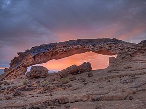
![Narrows in Diana's Throne Canyon, also known as the Huntress Slot in vicinity of Mount Carmel Junction.[1]](http://upload.wikimedia.org/wikipedia/commons/thumb/6/63/Narrows_in_Dianas_Throne_Canyon_-_DyeClan.com_-_panoramio_%282%29.jpg/220px-Narrows_in_Dianas_Throne_Canyon_-_DyeClan.com_-_panoramio_%282%29.jpg) Narrows in Diana's Throne Canyon, also known as the Huntress Slot in vicinity of Mount Carmel Junction.[1] | |
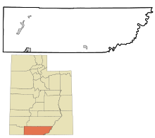
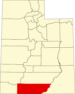 Location within the U.S. state of Utah | |
 Utah's location within the U.S. | |
| Coordinates: 37°17′N 111°53′W / 37.29°N 111.89°W | |
| Country | |
| State | |
| Founded | January 16, 1864 |
| Named for | Thomas L. Kane |
| Seat | Kanab |
| Largest city | Kanab |
| Area | |
| • Total | 4,109 sq mi (10,640 km2) |
| • Land | 3,990 sq mi (10,300 km2) |
| • Water | 118 sq mi (310 km2) 2.9% |
| Population (2010) | |
| • Total | 7,125 |
| • Estimate (2019) | 7,886 |
| • Density | 2/sq mi (0.8/km2) |
| Time zone | UTC−7 (Mountain) |
| • Summer (DST) | UTC−6 (MDT) |
| Congressional district | 2nd |
| Website | kane |

Kane County is a county in the U.S. state of Utah. As of the 2010 United States Census, the population was 7,125.[2] Its county seat and largest city is Kanab.[3]
History[]
The county was created on January 16, 1864 by the Utah Territory legislature, with areas partitioned from Washington County. It was named for Col. Thomas L. Kane,[4] a friend of the Mormon settlers in the 1840s and 1850s. The county boundary was adjusted in 1869, when a portion was returned to Washington County; in 1880, when San Juan County was created; and in 1883, when portions were partitioned from Kane and added to Iron and Washington counties.[5]
Geography[]
Kane County lies on the south line of the state of Utah. Its south border abuts the north border of the state of Arizona. The Colorado River, reformed as Lake Powell, forms its eastern border. Grand Staircase-Escalante National Monument covers much of the county. A rugged and inhospitable country of deserts, mountains and cliffs makes up the terrain, with breath-taking scenery in every area. Parts of Bryce Canyon National Park and Zion National Park extend into the northern and western portions of the county. The eastern part of the county is part of the Glen Canyon National Recreation Area.[6] The county has a total area of 4,109 square miles (10,640 km2), of which 3,990 square miles (10,300 km2) is land and 118 square miles (310 km2) (2.9%) is water.[7]
Adjacent counties[]
- Washington County - west
- Iron County - northwest
- Garfield County - north
- San Juan County - east
- Mohave County, Arizona - southwest
- Coconino County, Arizona - south
Protected areas[]
- Bryce Canyon National Park (part)
- Coral Pink Sand Dunes State Park
- Dixie National Forest (part)
- Glen Canyon National Recreation Area (part)
- Grand Staircase-Escalante National Monument (part)
- Kodachrome Basin State Park
- Zion National Park (part)
Lakes[6][]
- Lake Powell (along east border)
- Navajo Lake
Demographics[]
| Historical population | |||
|---|---|---|---|
| Census | Pop. | %± | |
| 1870 | 1,513 | — | |
| 1880 | 3,085 | 103.9% | |
| 1890 | 1,685 | −45.4% | |
| 1900 | 1,811 | 7.5% | |
| 1910 | 1,652 | −8.8% | |
| 1920 | 2,054 | 24.3% | |
| 1930 | 2,235 | 8.8% | |
| 1940 | 2,561 | 14.6% | |
| 1950 | 2,299 | −10.2% | |
| 1960 | 2,667 | 16.0% | |
| 1970 | 2,421 | −9.2% | |
| 1980 | 4,024 | 66.2% | |
| 1990 | 5,169 | 28.5% | |
| 2000 | 6,046 | 17.0% | |
| 2010 | 7,125 | 17.8% | |
| 2019 (est.) | 7,886 | 10.7% | |
| US Decennial Census[8] 1790–1960[9] 1900–1990[10] 1990–2000[11] 2010–2018[2] 2019[12] | |||
2000 census[]
As of the 2000 United States Census, there were 6,046 people, 2,237 households, and 1,628 families in the county. The population density was 1.52/sqmi (0.59/km2). There were 3,767 housing units at an average density of 0.94/sqmi (0.36/km2). The racial makeup of the county was 96.00% White, 0.03% Black or African American, 1.55% Native American, 0.22% Asian, 0.05% Pacific Islander, 0.74% from other races, and 1.41% from two or more races. 2.32% of the population were Hispanic or Latino of any race. The top 5 ethnic groups in Kane County are:
There were 2,237 households, out of which 32.20% had children under the age of 18 living with them, 64.60% were married couples living together, 6.00% had a female householder with no husband present, and 27.20% were non-families. 23.30% of all households were made up of individuals, and 10.20% had someone living alone who was 65 years of age or older. The average household size was 2.67 and the average family size was 3.21.
The county population contained 29.40% under the age of 18, 6.80% from 18 to 24, 21.20% from 25 to 44, 25.90% from 45 to 64, and 16.70% who were 65 years of age or older. The median age was 39 years. For every 100 females there were 98.30 males. For every 100 females age 18 and over, there were 94.10 males.
The median income for a household in the county was $34,247, and the median income for a family was $40,030. Males had a median income of $30,655 versus $20,406 for females. The per capita income for the county was $15,455. About 5.50% of families and 7.90% of the population were below the poverty line, including 9.30% of those under age 18 and 5.40% of those age 65 or over.
Politics[]
Kane is one of the most reliably Republican counties in the nation. Of "straight-ticket" voters in the 2008 election there were 992 Republicans and 326 Democrats. In the Utah gubernatorial election, 2004 nearly 70% of the county's vote went for Jon Huntsman, Jr. and in the 2008 election he received around 75% of the vote. Kane County is part of Utah's 2nd congressional district and thus was represented by moderate Democrat Jim Matheson for several years, until 2013. The second district is now represented by Republican Chris Stewart, elected in 2012 when Jim Matheson ran for election to the newly created fourth district instead of remaining in the second.
In Presidential elections, Kane County has only been won once by a Democratic candidate when Woodrow Wilson carried the county in 1916. It was the only county in Utah carried by Alf Landon, the Republican opponent who lost to Franklin Delano Roosevelt in the 1936 Presidential election in the most lopsided Presidential election in over a century. It has solidly favored the Republican candidate since at least 1956, when Dwight D. Eisenhower received approximately 90% of the vote. In 1964 the county went for Barry Goldwater, who lost the overall in the state, by over thirty-nine percent. Since 1920, only in the Democratic landslides of 1936, 1940 and 1964 did the Democratic candidate for president receive even 30% of the county's vote.[13]
Communities[]
City[]
- Kanab (county seat)
Towns[]
Unincorporated communities[]
- Bullfrog
- Duck Creek Village
- Mount Carmel
- Mount Carmel Junction
Ghost town[]
See also[]
References[]
- ^ Diana's Throne
- ^ Jump up to: a b "State & County QuickFacts". United States Census Bureau. Archived from the original on June 6, 2011. Retrieved December 29, 2013.
- ^ "Find a County". National Association of Counties. Archived from the original on May 31, 2011. Retrieved June 7, 2011.
- ^ Gannett, Henry (1905). The Origin of Certain Place Names in the United States. Govt. Print. Off. p. 172.
- ^ "[[Newberry Library]]. Individual County Chronologies - Kane County UT (accessed March 25, 2019)". Archived from the original on March 6, 2016. Retrieved March 25, 2019.
- ^ Jump up to: a b Kane County UT Google Maps (accessed 25 March 2019)
- ^ "2010 Census Gazetteer Files". US Census Bureau. August 22, 2012. Retrieved June 25, 2015.
- ^ "US Decennial Census". US Census Bureau. Archived from the original on April 26, 2015. Retrieved June 25, 2015.
- ^ "Historical Census Browser". University of Virginia Library. Retrieved June 25, 2015.
- ^ Forstall, Richard L., ed. (June 25, 1995). "Population of Counties by Decennial Census: 1900 to 1990". US Census Bureau. Retrieved March 27, 2015.
- ^ "Census 2000 PHC-T-4. Ranking Tables for Counties: 1990 and 2000" (PDF). US Census Bureau. April 2, 2001. Retrieved June 25, 2015.
- ^ "QuickFacts. Utah counties". Retrieved May 17, 2020.
- ^ Jump up to: a b Leip, David. "Atlas of US Presidential Elections". uselectionatlas.org. Retrieved March 31, 2018.
External links[]
| show Places adjacent to Kane County, Utah |
|---|
| show Municipalities and communities of Kane County, Utah, United States |
|---|


- Utah counties
- Kane County, Utah
- 1864 establishments in Utah Territory
- Populated places established in 1864