Canyonlands National Park
| Canyonlands National Park | |
|---|---|
IUCN category II (national park) | |
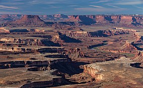 Looking over the Green River from Island in the Sky | |
 Location in United States | |
| Location | San Juan, Wayne, Garfield, and Grand counties, Utah, United States |
| Nearest city | Moab, Utah |
| Coordinates | 38°10′01″N 109°45′35″W / 38.16691°N 109.75966°WCoordinates: 38°10′01″N 109°45′35″W / 38.16691°N 109.75966°W |
| Area | 337,598 acres (1,366.21 km2)[1] |
| Established | September 12, 1964[2] |
| Visitors | 733,996 (in 2019)[3] |
| Governing body | National Park Service |
| Website | Canyonlands National Park |


Canyonlands National Park is an American national park located in southeastern Utah near the town of Moab. The park preserves a colorful landscape eroded into numerous canyons, mesas, and buttes by the Colorado River, the Green River, and their respective tributaries. Legislation creating the park was signed into law by President Lyndon Johnson on September 12, 1964.[4]
The park is divided into four districts: the Island in the Sky, the Needles, the Maze, and the combined rivers—the Green and Colorado—which carved two large canyons into the Colorado Plateau. While these areas share a primitive desert atmosphere, each retains its own character.[5] Author Edward Abbey, a frequent visitor, described the Canyonlands as "the most weird, wonderful, magical place on earth—there is nothing else like it anywhere."[6]
History[]
In the early 1950s, Bates Wilson, then superintendent of Arches National Monument, began exploring the area to the south and west of Moab, Utah. After seeing what is now known as the Needles District of Canyonlands National Park, Wilson began advocating for the establishment of a new national park that would include the Needles. Additional explorations by Wilson and others expanded the areas proposed for inclusion into the new national park to include the confluence of Green and Colorado rivers, the Maze District, and Horseshoe Canyon.[7]
In 1961, Secretary of the Interior Stewart Udall was scheduled to address a conference at Grand Canyon National Park. On his flight to the conference, he flew over the Confluence (where the Colorado and Green rivers meet). The view apparently sparked Udall's interest in Wilson's proposal for a new national park in that area and Udall began promoting the establishment of Canyonlands National Park.
Utah Senator Frank Moss first introduced legislation into Congress to create Canyonlands National Park. His legislation attempted to satisfy both nature preservationists' and commercial developers' interests. Over the next four years, his proposal was struck down, debated, revised, and reintroduced to Congress many times before being passed and signed into creation.[8]
In September, 1964, after several years of debate, President Lyndon B. Johnson signed Pub.L. 88–590, which established Canyonlands National Park as a new national park. Bates Wilson became the first superintendent of the new park and is often referred to as the "Father of Canyonlands."[9]
Recreation[]
Canyonlands is a popular recreational destination. Since 2007, more than 400,000 people have visited the park each year with a record of 776,218 visitors in 2016, representing a 22 percent increase from the prior year.[3] The geography of the park is well suited to a number of different recreational uses. Hikers, mountain bikers, backpackers, and four-wheelers all enjoy traveling the rugged, remote trails within the Park. The White Rim Road traverses the White Rim Sandstone level of the park between the rivers and the Island in the Sky. Since 2015, day-use permits must be obtained before travelling on the White Rim Road due to the increasing popularity of driving and bicycling along it. The park service's intent is to provide a better wilderness experience for all visitors while minimizing impacts on the natural surroundings.[10][11]

As of 2016, the Island in the Sky district, with its proximity to the Moab, Utah area, attracts 76.7 percent of total park visitors. The Needles district is the second most visited, drawing 20.7 percent of visitors. The remote Maze district accounts for only about 1.5 percent of visitors, while river rafters and other river users account for the remaining 1.1 percent of total park visitation.[12]
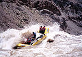
Rafters and kayakers float the calm stretches of the Green River and Colorado River above the Confluence. Below the Confluence, Cataract Canyon contains powerful whitewater rapids, similar to those found in the Grand Canyon. However, since there is no large impoundment on the Colorado River above Canyonlands National Park, river flow through the Confluence is determined by snowmelt, not management. As a result, and in combination with Cataract Canyon's unique graben geology, this stretch of river offers the largest whitewater in North America in heavy snow years.
Political compromise at the time of the park's creation limited the protected area to an arbitrary portion of the Canyonlands basin. Conservationists hope to complete the park by bringing the boundaries up to the high sandstone rims that form the natural border of the Canyonlands landscape.[13]
On March 27, 2020, Canyonlands National Park was closed to help prevent the spread of COVID-19.[14]
Geography[]

The Colorado River and Green River combine within the park, dividing it into three districts called the Island in the Sky, the Needles, and the Maze. The Colorado River flows through Cataract Canyon below its confluence with the Green River.
The Island in the Sky district is a broad and level mesa in the northern section of the park, between the Colorado and Green rivers. The district has many viewpoints overlooking the White Rim, a sandstone bench 1,200 feet (370 m) below the Island, and the rivers, which are another 1,000 feet (300 m) below the White Rim.
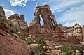
The Needles district is located south of the Island in the Sky, on the east side of the Colorado River. The district is named for the red and white banded rock pinnacles which are a major feature of the area. Various other naturally sculpted rock formations are also within this district, including grabens, potholes, and arches. Unlike Arches National Park, where many arches are accessible by short to moderate hikes, most of the arches in the Needles district lie in backcountry canyons, requiring long hikes or four-wheel drive trips to reach them.
The Ancestral Puebloans inhabited this area and some of their stone and mud dwellings are well-preserved, although the items and tools they used were mostly removed by looters.[15] The Ancestral Puebloans also created rock art in the form of petroglyphs, most notably on Newspaper Rock along the Needles access road.

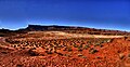
The Maze district is located west of the Colorado and Green rivers. The Maze is the least accessible section of the park, and one of the most remote and inaccessible areas of the United States.[16][17]
A geographically detached section of the park located north of the Maze district, Horseshoe Canyon contains panels of rock art made by hunter-gatherers from the Late Archaic Period (2000-1000 BC) pre-dating the Ancestral Puebloans.[18][19][20] Originally called Barrier Canyon, Horseshoe's artifacts, dwellings, pictographs, and murals are some of the oldest in America.[19] The images depicting horses date from after 1540 AD, when the Spanish reintroduced horses to America.[19]
Since the 1950s, scientists have been studying an area of 200 acres (81 ha) completely surrounded by cliffs. The cliffs have prevented cattle from ever grazing on the area's 62 acres (25 ha) of grassland. According to the scientists, the site may contain the largest undisturbed grassland in the Four Corners region. Studies have continued biannually since the mid-1990s. The area has been closed to the public since 1993 to maintain the nearly pristine environment.[21]
Wildlife[]
Fauna[]

Mammals that roam this park include black bears, coyotes, skunks, bats, elk, foxes, bobcats, badgers, ring-tailed cats, pronghorns, desert bighorn sheep, and cougars.[22] Desert cottontails, kangaroo rats and mule deer are commonly seen by visitors.[23]
At least 273 species of birds inhabit the park.[24] A variety of hawks and eagles are found, including the Cooper's hawk, the northern goshawk, the sharp-shinned hawk, the red-tailed hawk, the golden and bald eagles, the rough-legged hawk, the Swainson's hawk, and the northern harrier.[25] Several species of owls are found, including the great horned owl, the northern saw-whet owl, the western screech owl, and the Mexican spotted owl.[25] Grebes, woodpeckers, ravens, herons, flycatchers, crows, bluebirds, wrens, warblers, blackbirds, orioles, goldfinches, swallows, sparrows, ducks, quail, grouse, pheasants, hummingbirds, falcons, gulls, and ospreys are some of the other birds that can be found.[25]
Several reptiles can be found, including eleven species of lizards and eight species of snake (including the midget faded rattlesnake).[26] The common kingsnake and prairie rattlesnake have been reported in the park, but not confirmed by the National Park Service.[26]
The park is home to six confirmed amphibian species, including the red-spotted toad,[27] Woodhouse's toad,[28] American bullfrog,[29] northern leopard frog,[30] Great Basin spadefoot toad,[31] and tiger salamander.[32] The canyon tree frog was reported to be in the park in 2000, but was not confirmed during a study in 2004.[33]
Flora[]

Canyonlands National Park contains a wide variety of plant life, including 11 cactus species,[34] 20 moss species,[35] liverworts,[35] grasses[36] and wildflowers.[37] Varieties of trees include netleaf hackberry, Russian olive, Utah juniper, pinyon pine, tamarisk and Fremont's cottonwood.[38] Shrubs include Mormon tea, blackbrush, four-wing saltbush and cliffrose.[38]
Cryptobiotic soil is the foundation of life in Canyonlands, providing nitrogen fixation and moisture for plant seeds. One footprint can destroy decades of growth.[39]
Climate[]
According to the Köppen climate classification system, Canyonlands National Park has a cold semi-arid climate ("BSk"). The plant hardiness zones at the Island in the Sky and Needles District Visitor Centers are 7a with an average annual extreme minimum air temperature of 4.0 °F (-15.6 °C) and 2.9 °F (-16.2 °C), respectively.[40]
The National Weather Service has maintained two cooperative weather stations in the park since June 1965. Official data documents the desert climate with less than 10 inches (250 millimetres) of annual rainfall, as well as hot, mostly dry summers and cold, occasionally wet winters. Snowfall is generally light during the winter.
The station in The Neck region reports average January temperatures ranging from a high of 36.8 °F (2.7 °C) to a low of 22.3 °F (−5.4 °C). Average July temperatures range from a high of 90.8 °F (32.7 °C) to a low of 67.9 °F (19.9 °C). There are an average of 45.7 days with highs of 90 °F (32 °C) or higher and an average of 117.3 days with lows of 32 °F (0 °C) or lower. The highest recorded temperature was 105 °F (41 °C) on July 15, 2005, and the lowest recorded temperature was −13 °F (−25 °C) on February 6, 1989. Average annual precipitation is 9.33 inches (237 mm). There are an average of 59 days with measurable precipitation. The wettest year was 1984, with 13.66 in (347 mm), and the driest year was 1989, with 4.63 in (118 mm). The most precipitation in one month was 5.19 in (132 mm) in October 2006. The most precipitation in 24 hours was 1.76 in (45 mm) on April 9, 1978. Average annual snowfall is 22.8 in (58 cm). The most snowfall in one year was 47.4 in (120 cm) in 1975, and the most snowfall in one month was 27.0 in (69 cm) in January 1978.[41]
The station in The Needles region reports average January temperatures ranging from a high of 41.2 °F (5.1 °C) to a low of 16.6 °F (−8.6 °C). Average July temperatures range from a high of 95.4 °F (35.2 °C) to a low of 62.4 °F (16.9 °C). There are an average of 75.4 days with highs of 90 °F (32 °C) or higher and an average of 143.6 days with lows of 32 °F (0 °C) or lower. The highest recorded temperature was 107 °F (42 °C) on July 13, 1971, and the lowest recorded temperature was −16 °F (−27 °C) on January 16, 1971. Average annual precipitation is 8.49 in (216 mm). There are an average of 56 days with measurable precipitation. The wettest year was 1969, with 11.19 in (284 mm), and the driest year was 1989, with 4.25 in (108 mm). The most precipitation in one month was 4.43 in (113 mm) in October 1972. The most precipitation in 24 hours was 1.56 in (40 mm) on September 17, 1999. Average annual snowfall is 14.4 in (37 cm). The most snowfall in one year was 39.3 in (100 cm) in 1975, and the most snowfall in one month was 24.0 in (61 cm) in March 1985.[42]
| hideClimate data for Canyonlands - The Neck, Utah, 1991-2020 normals, extremes 1965-present | |||||||||||||
|---|---|---|---|---|---|---|---|---|---|---|---|---|---|
| Month | Jan | Feb | Mar | Apr | May | Jun | Jul | Aug | Sep | Oct | Nov | Dec | Year |
| Record high °F (°C) | 58 (14) |
67 (19) |
78 (26) |
84 (29) |
97 (36) |
102 (39) |
105 (41) |
101 (38) |
98 (37) |
89 (32) |
72 (22) |
62 (17) |
105 (41) |
| Average high °F (°C) | 36.8 (2.7) |
43.2 (6.2) |
54.2 (12.3) |
62.0 (16.7) |
72.4 (22.4) |
84.6 (29.2) |
90.8 (32.7) |
87.8 (31.0) |
79.0 (26.1) |
64.6 (18.1) |
49.1 (9.5) |
36.9 (2.7) |
63.4 (17.4) |
| Daily mean °F (°C) | 29.6 (−1.3) |
35.2 (1.8) |
44.5 (6.9) |
51.1 (10.6) |
61.3 (16.3) |
73.1 (22.8) |
79.3 (26.3) |
76.8 (24.9) |
68.0 (20.0) |
54.3 (12.4) |
40.8 (4.9) |
29.7 (−1.3) |
53.6 (12.0) |
| Average low °F (°C) | 22.3 (−5.4) |
27.3 (−2.6) |
34.9 (1.6) |
40.1 (4.5) |
50.2 (10.1) |
61.7 (16.5) |
67.9 (19.9) |
65.7 (18.7) |
57.0 (13.9) |
43.9 (6.6) |
32.6 (0.3) |
22.6 (−5.2) |
43.8 (6.6) |
| Record low °F (°C) | −7 (−22) |
−13 (−25) |
0 (−18) |
14 (−10) |
22 (−6) |
26 (−3) |
41 (5) |
41 (5) |
25 (−4) |
9 (−13) |
6 (−14) |
−10 (−23) |
−13 (−25) |
| Average precipitation inches (mm) | 0.55 (14) |
0.58 (15) |
0.75 (19) |
0.68 (17) |
0.87 (22) |
0.36 (9.1) |
0.91 (23) |
1.16 (29) |
1.00 (25) |
1.22 (31) |
0.55 (14) |
0.70 (18) |
9.33 (237) |
| Average snowfall inches (cm) | 6.1 (15) |
3.5 (8.9) |
3.0 (7.6) |
0.3 (0.76) |
0.1 (0.25) |
0.0 (0.0) |
0.0 (0.0) |
0.0 (0.0) |
0.0 (0.0) |
0.1 (0.25) |
3.2 (8.1) |
6.5 (17) |
22.8 (58) |
| Average precipitation days (≥ 0.01 in) | 4.4 | 4.5 | 4.6 | 5.2 | 5.4 | 2.4 | 5.9 | 6.4 | 6.2 | 5.7 | 4.3 | 4.4 | 59.4 |
| Average snowy days (≥ 0.1 in) | 3.8 | 2.5 | 1.7 | 0.5 | 0.1 | 0.0 | 0.0 | 0.0 | 0.0 | 0.3 | 1.7 | 3.6 | 14.2 |
| Source: NOAA[43][44] | |||||||||||||
Geology[]

A subsiding basin and nearby uplifting mountain range (the Uncompahgre) existed in the area in Pennsylvanian time. Seawater trapped in the subsiding basin created thick evaporite deposits by Mid Pennsylvanian. This, along with eroded material from the nearby mountain range, became the Paradox Formation, itself a part of the Hermosa Group. Paradox salt beds started to flow later in the Pennsylvanian and probably continued to move until the end of the Jurassic.[45] Some scientists believe Upheaval Dome was created from Paradox salt bed movement, creating a salt dome, but more modern studies show that the meteorite theory is more likely to be correct.
A warm shallow sea again flooded the region near the end of the Pennsylvanian. Fossil-rich limestones, sandstones, and shales of the gray-colored Honaker Trail Formation resulted. A period of erosion then ensued, creating a break in the geologic record called an unconformity. Early in the Permian an advancing sea laid down the Halgaito Shale. Coastal lowlands later returned to the area, forming the Elephant Canyon Formation.
Large alluvial fans filled the basin where it met the Uncompahgre Mountains, creating the Cutler red beds of iron-rich arkose sandstone. Underwater sand bars and sand dunes on the coast inter-fingered with the red beds and later became the white-colored cliff-forming Cedar Mesa Sandstone. Brightly colored oxidized muds were then deposited, forming the Organ Rock Shale. Coastal sand dunes and marine sand bars once again became dominant, creating the White Rim Sandstone.

A second unconformity was created after the Permian sea retreated. Flood plains on an expansive lowland covered the eroded surface and mud built up in tidal flats, creating the Moenkopi Formation. Erosion returned, forming a third unconformity. The Chinle Formation was then laid down on top of this eroded surface.
Increasingly dry climates dominated the Triassic. Therefore, sand in the form of sand dunes invaded and became the Wingate Sandstone. For a time climatic conditions became wetter and streams cut channels through the sand dunes, forming the Kayenta Formation. Arid conditions returned to the region with a vengeance; a large desert spread over much of western North America and later became the Navajo Sandstone. A fourth unconformity was created by a period of erosion.
Mud flats returned, forming the Carmel Formation, and the Entrada Sandstone was laid down next. A long period of erosion stripped away most of the San Rafael Group in the area, along with any formations that may have been laid down in the Cretaceous period.
The Laramide orogeny started to uplift the Rocky Mountains 70 million years ago and with it, the Canyonlands region. Erosion intensified and when the Colorado River Canyon reached the salt beds of the Paradox Formation the overlying strata extended toward the river canyon, forming features such as The Grabens.[46] Increased precipitation during the ice ages of the Pleistocene quickened the rate of canyon excavation along with other erosion. Similar types of erosion are ongoing, but occur at a slower rate.
Gallery[]

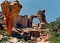
Mesa Arch at sunrise, Island in the Sky district


See also[]
- List of national parks of the United States
- Bears Ears National Monument
- Goblin Valley State Park
- Indian Creek Wilderness Study Area
References[]
- ^ "Listing of acreage as of December 31, 2011" (PDF). Land Resource Division, National Park Service. Retrieved 2012-03-06.
- ^ An Act To provide for establishment of the Canyonlands National Park in the State of Utah, and for other purposes. Pub.L. 850–590 (text) (pdf). 12 September 1964.
- ^ Jump up to: a b "Canyonlands NP Recreation Visitors". irma.nps.gov. National Park Service. n.d. Archived from the original on February 8, 2017. Retrieved February 23, 2018.
- ^ "Canyonlands Visitor Guide 2014" (PDF). National Park Service. Archived from the original (PDF) on October 14, 2014. Retrieved September 25, 2014.
- ^ "Canyonlands". National Park Service. Archived from the original on 2015-06-19. Retrieved 2011-06-09.
- ^ Abbey, Edward (2006). Postcards from Ed: Dispatches and Salvos from an American Iconoclast. Milkweed Press. p. 175. ISBN 1-57131-284-6.
- ^ "National Park Service: A Conversation with Bates Wilson". Archived from the original on 2017-08-17. Retrieved 2017-08-16.
- ^ Smith, Thomas (1991). "The Canyonland National Park Controversy". History To Go. Retrieved 2020-11-12.
- ^ "Bates E. Wilson (U.S. National Park Service)". www.nps.gov. Retrieved 2020-11-06.
- ^ "Day-use permits". National Park Service. 2016-01-26. Archived from the original on 2016-01-28. Retrieved 2016-01-26.
- ^ "NPS proposes permit system for White Rim and Elephant Hill". Moab Sun News, Moab, Utah. 2015-03-26. Archived from the original on 2016-01-27. Retrieved 2016-01-26.
- ^ "Park Specific Reports/Park YTD/Canyonlands NP/Report Date: Dec 2016". irma.nps.gov. National Park Service. n.d. Archived from the original on 2017-02-08. Retrieved 2017-02-08.
- ^ Keiter, Robert B.; Stephen Trimble (2008–2009). "Canyonlands Completion report: Negotiating the Borders". University of Utah. Retrieved 2011-06-09.
- ^ "3 More National Parks Close to Prevent Coronavirus Spread". Time. Archived from the original on 2020-04-06. Retrieved 2020-04-21.
- ^ "Native Americans". National Park Service. Archived from the original on 2008-06-12. Retrieved 2008-08-21.
- ^ "Maze". National Park Service. Archived from the original on 2008-09-24. Retrieved 2008-08-21.
- ^ "Geology Footnotes". Explore Nature. National Park Service. Archived from the original on 2011-09-26. Retrieved 2011-06-11.
- ^ Geib, Phil R.; Michael R. Robins. "Analysis and Dating of the Great Gallery Tool and Food Bag". National Park Service. Archived from the original on 2011-11-09. Retrieved 2011-06-11.
- ^ Jump up to: a b c Hitchman, Robert. "The Great Gallery of Horseshoe Canyon". Apogee Photo Magazine. Archived from the original on 2008-03-04. Retrieved 2011-06-11.
- ^ "The Archeology of Horseshoe Canyon" (PDF). National Park Service. Archived (PDF) from the original on 2011-05-15. Retrieved 2011-06-11.
- ^ Hollenhorst, John (2019-10-26). "Hiking into a place so undisturbed that it's a government secret". Deseret News. Archived from the original on 2019-10-27. Retrieved 2019-10-28.
- ^ "Species List - Mammals - Canyonlands National Park". National Park Service. Archived from the original on September 16, 2016. Retrieved July 30, 2016.
- ^ "Mammals - Canyonlands National Park". National Park Service. Archived from the original on July 15, 2016. Retrieved July 30, 2016.
- ^ "Birds - Canyonlands National Park". National Park Service. Archived from the original on July 15, 2016. Retrieved July 30, 2016.
- ^ Jump up to: a b c "Species List - Birds - Canyonlands National Park". National Park Service. Archived from the original on September 16, 2016. Retrieved July 30, 2016.
- ^ Jump up to: a b "Species List - Reptiles - Canyonlands National Park". National Park Service. Archived from the original on September 15, 2016. Retrieved July 30, 2016.
- ^ "Species Profile - Bufo punctatus - Canyonlands National Park (CANY) - Present". National Park Service. Archived from the original on September 15, 2016. Retrieved July 30, 2016.
- ^ "Species Profile - Bufo woodhousii - Canyonlands National Park (CANY) - Present". National Park Service. Archived from the original on September 16, 2016. Retrieved July 30, 2016.
- ^ "Species Profile - Rana catesbeiana - Canyonlands National Park (CANY) - Present". National Park Service. Archived from the original on September 16, 2016. Retrieved July 30, 2016.
- ^ "Species Profile - Rana pipiens - Canyonlands National Park (CANY) - Present". National Park Service. Archived from the original on September 16, 2016. Retrieved July 30, 2016.
- ^ "Species Profile - Spea intermontana - Canyonlands National Park (CANY) - Present". National Park Service. Archived from the original on September 16, 2016. Retrieved July 30, 2016.
- ^ "Species Profile - Ambystoma tigrinum - Canyonlands National Park (CANY) - Present". National Park Service. Archived from the original on September 16, 2016. Retrieved July 30, 2016.
- ^ "Species Profile - Hyla arenicolor - Canyonlands National Park (CANY) - Unconfirmed". National Park Service. Archived from the original on September 15, 2016. Retrieved July 30, 2016.
- ^ "Cacti / Desert Succulents - Canyonlands National Park (U.S. National Park Service)". www.nps.gov. Archived from the original on 2018-06-17. Retrieved 2018-06-17.
- ^ Jump up to: a b "Mosses and Liverworts - Canyonlands National Park (U.S. National Park Service)". www.nps.gov. Archived from the original on 2018-06-17. Retrieved 2018-06-17.
- ^ "Grasses - Canyonlands National Park (U.S. National Park Service)". www.nps.gov. Archived from the original on 2018-06-17. Retrieved 2018-06-17.
- ^ "Wildflowers - Canyonlands National Park (U.S. National Park Service)". www.nps.gov. Archived from the original on 2018-06-17. Retrieved 2018-06-17.
- ^ Jump up to: a b "Trees and Shrubs - Canyonlands National Park (U.S. National Park Service)". www.nps.gov. Archived from the original on 2018-06-17. Retrieved 2018-06-17.
- ^ Schneider, Bill (2017). Best Easy Day Hikes: Canyonlands and Arches National Parks (4th ed.). Guilford, Connecticut: Falcon Guides. p. 9. ISBN 978-1-4930-2737-8. Retrieved November 26, 2020.
- ^ "USDA Interactive Plant Hardiness Map". United States Department of Agriculture. Archived from the original on 2019-07-04. Retrieved 2019-07-03.
- ^ "Canyonlands The Neck, Utah". Western Regional Climate Center. Archived from the original on 2012-03-21. Retrieved 2011-06-11.
- ^ "Canyonlands The Needle, Utah". Western Regional Climate Center. Archived from the original on 2012-03-21. Retrieved 2011-06-11.
- ^ "NOWData - NOAA Online Weather Data". National Oceanic and Atmospheric Administration. Retrieved June 12, 2021.
- ^ "Summary of Monthly Normals 1991-2020". National Oceanic and Atmospheric Administration. Retrieved June 12, 2021.
- ^ Harris, Ann C. (1998). Geology of National Parks. Kendall Hunt Publishing Co. ISBN 0-7872-5353-7.
- ^ "The Grabens: Canyonlands National Park". nps.gov. National Park Service. 2018-01-08. Archived from the original on 2020-02-26. Retrieved 2020-02-26.
Further reading[]
- Harris, Ann C. (1998). Geology of National Parks. Kendall Hunt Publishing Co. ISBN 0-7872-5353-7.
- Zwinger, Ann (1986). Wind in the Rock. Tucson, AZ: University of Arizona Press. ISBN 978-0-8165-0985-0.
- Johnson, David (1989). Canyonlands: The Story Behind the Scenery. Las Vegas, NV: KC Publications. ISBN 0-88714-034-3.
- The National parks : index, 2009-2011 (PDF) (Rev. to include the actions of the 110th Congress ending Jan. 3, 2009. ed.). Washington, DC: The Office of Public Affairs, and the Division of Publications, National Park Service. 2009. ISBN 9780912627816. Archived from the original (PDF) on 2011-10-16. Retrieved 2011-06-11.
External links[]
 Definitions from Wiktionary
 Media from Wikimedia Commons
 News from Wikinews
 Quotations from Wikiquote
 Texts from Wikisource
 Textbooks from Wikibooks
 Travel guide from Wikivoyage
 Resources from Wikiversity
- Official website by the National Park Service
- Canyonlands Field Institute (a non-profit support group)
- Canyonlands Natural History Association (a non-profit organization established to assist the scientific and educational efforts of the NPS)
- Spherical panoramas of Canyonlands
- DigitalCommons@USU (Canyonlands Research Publications from Utah State University)
| show National parks of the United States |
|---|

| show |
|---|

| show Colorado River system |
|---|


| show Authority control |
|---|
- IUCN Category II
- Canyonlands National Park
- National parks in Utah
- Canyons and gorges of Utah
- Rock formations of Utah
- Protected areas on the Colorado River
- Protected areas of Garfield County, Utah
- Protected areas of Grand County, Utah
- Protected areas of San Juan County, Utah
- Protected areas of Wayne County, Utah
- Archaeological sites in Utah
- Colorado Plateau
- Green River (Colorado River tributary)
- Geologic formations with imbedded sand dunes
- Sandstone formations of the United States
- Canyons and gorges of Garfield County, Utah
- Canyons and gorges of Grand County, Utah
- Landforms of San Juan County, Utah
- Landforms of Wayne County, Utah
- Protected areas established in 1964
- 1964 establishments in Utah
- Badlands of the United States