Washington State Route 501
 | ||||
|---|---|---|---|---|
| Erwin O. Rieger Memorial Highway | ||||
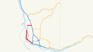 The existing highway is highlighted in red. The proposed completion is shown in dashed purple. | ||||
| Route information | ||||
| Auxiliary route of I-5 | ||||
| Maintained by WSDOT | ||||
| Length | 13.97 mi[1] (22.48 km) | |||
| Existed | 1964[2]–present | |||
| Southern section | ||||
| Length | 11.00 mi[1] (17.70 km) | |||
| South end | ||||
| North end | Ridgefield NWR near Vancouver | |||
| Northern section | ||||
| Length | 2.97 mi[1] (4.78 km) | |||
| West end | Main Street in Ridgefield | |||
| East end | ||||
| Location | ||||
| Counties | Clark | |||
| Highway system | ||||
| ||||
State Route 501 (SR 501, designated as the Erwin O. Rieger Memorial Highway) is a 13.97-mile-long (22.48 km) state highway in the southern part of the U.S. state of Washington. It is split into two sections in Clark County, a north–south alignment connecting Interstate 5 (I-5) in Vancouver to the Port of Vancouver and the Ridgefield National Wildlife Refuge, and a west–east alignment connecting Ridgefield to I-5. Prior to the 1964 highway renumbering, SR 501 was designated as Secondary State Highway 1T (SSH 1T), established in 1937 and re-aligned to serve the Port of Vancouver in 1963.
Route description[]
Southern section[]

The 11.00-mile-long (17.70 km) southern section of SR 501 and the Erwin O. Rieger Memorial Highway begins as the four-lane Mill Plain Boulevard at a diamond interchange with I-5 in Downtown Vancouver.[1][3] The highway travels west through Downtown Vancouver and splits into a one-way pair on Mill Plain Boulevard and 15th Street before rejoining as Mill Plain Boulevard.[4] SR 501 crosses a BNSF rail yard and enters the Port of Vancouver, becoming the Lower River Road and narrowing to a two-lane highway on the south side of Vancouver Lake.[5] The highway follows the Columbia and Lake rivers north past the , ending south of in the Ridgefield National Wildlife Refuge.[6]
Every year, the Washington State Department of Transportation (WSDOT) conducts a series of surveys on its highways in the state to measure traffic volume. This is expressed in terms of average annual daily traffic (AADT), which is a measure of traffic volume for any average day of the year. In 2011, WSDOT calculated that the busiest section of SR 501 overall was west of I-5 at C Street, serving 13,000 vehicles, while the least busiest section of SR 501 overall was south of Shillapoo Wildlife Recreation Area, serving 650 vehicles.[7] Between I-5 and the Port of Vancouver, SR 501 is designated as part of WSDOT's Highway of Statewide Significance,[8] which include interstate highways and other principal arterials that are needed to connect major communities in the state of Washington.[9]
Northern section[]

The 2.97-mile-long (4.78 km) northern section of SR 501 within Ridgefield begins as Pioneer Street at an intersection with Main Avenue at the Ridgefield City Hall.[1] The highway travels east through Downtown Ridgefield, passing , before crossing over Gee Creek. SR 501 continues east through two roundabouts, at 45th Avenue and 56th Place, before ending at a diamond interchange with I-5.[10][11]
Every year, WSDOT conducts a series of surveys on its highways in the state to measure traffic volume. This is expressed in terms of AADT, which is a measure of traffic volume for any average day of the year. In 2011, WSDOT calculated that the busiest section of the northern section was the I-5 interchange, serving 11,000 vehicles, while the least busiest section was the intersection with Main Street in Downtown Ridgefield, serving 3,200 vehicles.[7]
History[]
SSH 1T was created in 1937 during the formation of the primary and secondary state highways,[12] traveling on a 18.86-mile-long (30.35 km) route north from Primary State Highway 1 (PSH 1) and U.S. Route 99 (US 99) in Vancouver through Felida and Ridgefield to PSH 1 and US 99 at Pioneer.[13][14] The highway was extended into Vancouver in the 1950s[15] and re-aligned in 1963 to serve the Port of Vancouver, traveling along the Columbia River to Ridgefield west of Vancouver Lake onto a roadway that was to be constructed.[16] The state highway commission realigned the highway onto a pair of one-way streets within Vancouver in late 1968.[17] The first section of the Columbia River segment was completed in 1969, but the remainder never left the design phase.[18] SSH 1T became SR 501 during the 1964 highway renumbering and codified as such in 1970,[19][20] being designated as the Erwin O. Rieger Memorial Highway in 1991.[21] In the late 1990s, Mill Plain Boulevard was extended west from downtown Vancouver to the industrial area west of the railyard to serve the Port of Vancouver. The $35 million project was dedicated on September 30, 2000, and incorporated into SR 501.[22]
The section of the highway between the Ridgefield National Wildlife Refuge and the city of Ridgefield has never been constructed and remains as a physical gap in the state highway system.[23] The interchange between I-5 and SR 501 east of Ridgefield was rebuilt by WSDOT between 2010 and 2012, adding roundabouts at intersections west and east of the interchange as well.[24] On July 14, 2015, WSDOT permanently closed the northern 1+1⁄3-mile-long (2.1 km) of SR 501's southern section due to the Columbia River reclaiming the highway.[25] That part of the highway was relinquished to Clark County in 2016.[26] Eventually, that section was vacated to surrounding property owners.[26]
Major intersections[]
The entire highway is in Clark County.
| Location | mi[1] | km | Destinations | Notes | |||
|---|---|---|---|---|---|---|---|
| Vancouver | 0.00– 0.05 | 0.00– 0.080 | I-5 exit 1C; interchange. | ||||
| | 11.00 | 17.70 | Ridgefield National Wildlife Refuge | ||||
| Gap in route | |||||||
| Ridgefield | 11.00 | 17.70 | Main Avenue | ||||
| 13.88– 13.97 | 22.34– 22.48 | I-5 exit 14; interchange. | |||||
| 1.000 mi = 1.609 km; 1.000 km = 0.621 mi | |||||||
References[]
- ^ a b c d e f Strategic Planning Division (March 5, 2012). State Highway Log Planning Report 2011, SR 2 to SR 971 (PDF) (Report). Washington State Department of Transportation. pp. 1482–1487. Retrieved February 10, 2013.
{{cite report}}: CS1 maint: url-status (link) - ^ "47.17.640: State route No. 501 — Erwin O. Rieger Memorial Highway". Revised Code of Washington. Washington State Legislature. 1970; revised 1984, 1991. Retrieved February 10, 2013.
{{cite web}}: Check date values in:|date=(help) - ^ "SR 5 - Exit 1C: Junction SR 501/Mill Plain Blvd" (PDF). Washington State Department of Transportation. May 25, 2011. Retrieved February 10, 2013.
- ^ "SR 501: Junction SR 501 CO VANCVR" (PDF). Washington State Department of Transportation. October 3, 2004. Retrieved February 10, 2013.
- ^ 2011 Washington State Rail System (PDF) (Map). Washington State Department of Transportation. January 2012. Retrieved February 10, 2013.
- ^ Google (February 10, 2013). "State Route 501" (Map). Google Maps. Google. Retrieved February 10, 2013.
- ^ a b Staff (2011). "2011 Annual Traffic Report" (PDF). Washington State Department of Transportation. pp. 184–185. Retrieved February 10, 2013.
- ^ "Transportation Commission List of Highways of Statewide Significance" (PDF). Washington State Transportation Commission. July 26, 2009. Retrieved February 10, 2013.
- ^ Lorenzo, Judy. "Highways of Statewide Significance". Washington State Department of Transportation. Retrieved February 10, 2013.
- ^ "SR 5 - Exit 14: Junction SR 501/Pioneer Street" (PDF). Washington State Department of Transportation. May 24, 2011. Retrieved February 10, 2013.
- ^ Google (February 10, 2013). "State Route 501" (Map). Google Maps. Google. Retrieved February 10, 2013.
- ^ Washington State Legislature (March 18, 1937). "Chapter 207: Classification of Public Highways". Session Laws of the State of Washington. Session Laws of the State of Washington (1937 ed.). Olympia, Washington: Washington State Legislature. p. 997. Retrieved February 10, 2013.
(s) Secondary State Highway No. 1T; beginning at Vancouver on Primary State Highway No. 1, thence in a northerly direction by the most feasible route by way of Sara to Ridgefield, thence in an easterly direction by the most feasible route to a junction with Primary State Highway No. 1 in the vicinity south of LaCenter.
- ^ Staff (1960). "Annual Traffic Report, 1960" (PDF). Washington State Highway Commission, Department of Highways. p. 161. Retrieved February 10, 2013.
- ^ Vancouver, 1949 (JPG) (Map). 1:250,000. United States Geological Survey. 1949. Retrieved February 10, 2013.
- ^ "To Extend Highway". The Daily Chronicle. Centralia. March 29, 1954. p. 3. Retrieved September 22, 2021 – via Newspapers.com.
- ^ Washington State Legislature (1963). "Extended Session 3". Session Laws of the State of Washington. Session Laws of the State of Washington (1963 ed.). Olympia, Washington: Washington State Legislature.
- ^ Goetz, Lorenz (December 1968). "Commission Report". Washington Highway News. Washington State Department of Highways. p. 12. OCLC 29654162. Retrieved September 22, 2021 – via WSDOT Library Digital Collections.
- ^ "What's up with that? Highway will continue its journey to nowhere". The Columbian. September 2, 2009. Archived from the original on August 20, 2018. Retrieved August 19, 2018 – via HighBeam.
- ^ Prahl, C. G. (December 1, 1965). "Identification of State Highways" (PDF). Washington State Highway Commission, Department of Highways. Retrieved February 7, 2013.
- ^ Vancouver, 1967 (JPG) (Map). 1:250,000. United States Geological Survey. 1967. Retrieved February 7, 2013.
- ^ Washington State Legislature (May 9, 1991). "Chapter 78: House Bill 1946 - Erwin O. Rieger Memorial Highway". Session Laws of the State of Washington. Session Laws of the State of Washington (1991 ed.). Olympia, Washington: Washington State Legislature. Retrieved February 10, 2013.
- ^ Ryll, Thomas (September 30, 2000). "Engine of change: Mill Plain extension bridge opens". The Columbian. Archived from the original on August 20, 2018. Retrieved August 19, 2018 – via HighBeam.
- ^ Washington State Highways, 2011–2012 (PDF) (Map). 1:842,000. Washington State Department of Transportation. 2011. Retrieved February 10, 2013.
- ^ "I-5 - SR 501 Ridgefield Interchange - Complete October 2012". Washington State Department of Transportation. October 2012. Retrieved February 10, 2013.
- ^ Hewitt, Scott (July 12, 2015). "Far segment of Lower River Road closes to cars Tuesday". The Columbian. Retrieved July 18, 2017.
- ^ a b Hewitt, Scott (July 12, 2017). "Dead end really the end for Lower River Road". The Columbian. Retrieved July 18, 2017.
External links[]
Route map:
| ( • help)
|
| ||
| ||
- State highways in Washington (state)
- Transportation in Clark County, Washington