Washington State Route 516
 | ||||
|---|---|---|---|---|
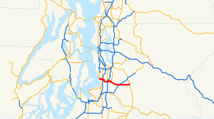 SR 516 is highlighted in red. | ||||
| Route information | ||||
| Auxiliary route of I-5 | ||||
| Maintained by WSDOT | ||||
| Length | 16.49 mi[1] (26.54 km) | |||
| Existed | 1964[2]–present | |||
| Major junctions | ||||
| West end | ||||
| East end | ||||
| Location | ||||
| Counties | King | |||
| Highway system | ||||
| ||||
State Route 516 (SR 516) is a 16.49-mile-long (26.54 km) state highway in the U.S. state of Washington, serving communities in southern King County. The highway travels east as the Kent-Des Moines Road and the Kent-Kangley Road from a concurrency with SR 509 in Des Moines through Kent and Covington to an intersection with SR 169 in Maple Valley. SR 516, designated as part of the National Highway System within Kent, intersects three major freeways in the area: Interstate 5 (I-5) in western Kent, SR 167 in downtown Kent, and SR 18 in Covington. The roadway, built in the 1890s, was codified in 1937 as Secondary State Highway 1K (SSH 1K) from Des Moines to Kent and SSH 5A from Kent to Maple Valley. The two highways were combined during the 1964 highway renumbering to form SR 516 on its current route.
Route description[]

SR 516 begins in Des Moines at Marine View Drive as SR 509 turns north towards Burien near the East Passage of Puget Sound. The two concurrent highways travel east on the Kent-Des Moines Road past Highline Community College and Mount Rainier High School to an intersection with SR 99 in western Kent, where SR 509 turns south towards Tacoma. SR 516 then intersects I-5 at a partial cloverleaf interchange and continues east onto a four-lane divided highway over the Green River and its pedestrian and bicycle trail into downtown Kent.[3][4] The highway serves as the southern terminus of SR 181 before intersecting SR 167 in a diamond interchange at the western edge of downtown Kent.[5] SR 516 shifts south onto Willis Street and crosses the Interurban Trail and a BNSF rail line before turning north onto Central Avenue and east onto Smith Street near Kent Station.[4][6] The highway travels southeast along Mill Creek onto the Kent-Kangley Road and serves as the southern terminus of SR 515 at Kent-Meridian High School before leaving Kent for Covington. SR 516 passes Lake Meridian as 272nd Street and intersects SR 18 at a diamond interchange located in Covington.[7] The highway continues east past Pipe Lake and into Maple Valley before crossing the Cedar to Green River Trail and ending at an intersection with SR 169.[1][4][8]
Every year, the Washington State Department of Transportation (WSDOT) conducts a series of surveys on its highways in the state to measure traffic volume. This is expressed in terms of annual average daily traffic (AADT), which is a measure of traffic volume for any average day of the year. In 2011, WSDOT calculated that the busiest section of the highway was between SR 181 and the SR 167 interchange, serving 38,000 vehicles, while the least busiest section was its western terminus at SR 509, serving 8,900 vehicles.[9] SR 516 between I-5 and SR 167 within western Kent is designated as part of the National Highway System,[10] which includes roadways important to the national economy, defense, and mobility.[11]
History[]
The Kent-Kangley Road was built as a wagon road by King County by the late 1890s and was upgraded to a paved highway after being codified as two highways during the creation of the primary and secondary state highways system in 1937: SSH 1K and SSH 5A.[12][13] SSH 1K traveled 12.76 miles (20.54 km) south from U.S. Route 99 and Primary State Highway 1 (PSH 1) through Burien and east through Des Moines to US 99 and PSH 1 in . SSH 5A traveled 14.50 miles (23.34 km) east from US 99 and PSH 1 in Midway across the Green River into Kent, intersecting SSH 5M, PSH 5, and SSH 5C, before ending at the Enumclaw–Renton branch of PSH 5 in Maple Valley.[14][15] The two highways were combined during the 1964 highway renumbering to form SR 516 and codified into law in 1970.[2][16] The highway traveled east from SR 509 in Des Moines through I-5 at Midway, SR 167 in Kent, and SR 18 in Covington to SR 169 in Maple Valley.[17] SR 509 was re-aligned in 1991 onto SR 516 and SR 99, forming new concurrencies, until the completion of a new north–south freeway.[18][19]
Major intersections[]

The entire highway is in King County.
| Location | mi[1] | km | Destinations | Notes | |
|---|---|---|---|---|---|
| Des Moines | 0.00 | 0.00 | Western terminus, west end of SR 509 overlap | ||
| Kent | 1.79 | 2.88 | East end of SR 509 overlap | ||
| 2.02 | 3.25 | Interchange | |||
| 4.79 | 7.71 | ||||
| 4.92 | 7.92 | Interchange | |||
| 7.61 | 12.25 | ||||
| Covington | 11.73 | 18.88 | Interchange | ||
| Maple Valley | 16.49 | 26.54 | Eastern terminus | ||
1.000 mi = 1.609 km; 1.000 km = 0.621 mi
| |||||
References[]
- ^ a b c Strategic Planning Division (January 25, 2013). State Highway Log Planning Report 2012, SR 2 to SR 971 (PDF) (Report). Washington State Department of Transportation. pp. 1586–1598. Retrieved February 23, 2013.
- ^ a b "47.17.710: State route No. 516". Revised Code of Washington. Washington State Legislature. 1970. Retrieved February 23, 2013.
- ^ "SR 5 - Exit 149: Junction SR 516" (PDF). Washington State Department of Transportation. October 19, 2010. Retrieved February 23, 2013.
- ^ a b c Bicycling in King County (PDF) (Map). King County. 2010. Archived from the original (PDF) on March 5, 2012. Retrieved February 23, 2013.
- ^ "SR 167: Junction SR 516/Willis St" (PDF). Washington State Department of Transportation. August 3, 2011. Retrieved February 23, 2013.
- ^ 2011 Washington State Rail System (PDF) (Map). Washington State Department of Transportation. January 2012. Retrieved February 23, 2013.
- ^ "SR 18: Junction SR 516" (PDF). Washington State Department of Transportation. September 21, 2004. Retrieved February 23, 2013.
- ^ Google (February 23, 2013). "State Route 516" (Map). Google Maps. Google. Retrieved February 23, 2013.
- ^ Staff (2011). "2011 Annual Traffic Report" (PDF). Washington State Department of Transportation. pp. 194–195. Retrieved February 23, 2013.
- ^ National Highway System: Seattle, WA (PDF) (Map). Federal Highway Administration. October 1, 2012. Retrieved February 23, 2013.
- ^ "What is the National Highway System?". Federal Highway Administration. September 26, 2012. Retrieved February 23, 2013.
- ^ Washington: Tacoma Quadrangle (JPG) (Map). 1:250,000. United States Geological Survey. March 1900. Retrieved February 24, 2013.
- ^ Washington State Legislature (March 18, 1937). "Chapter 207: Classification of Public Highways". Session Laws of the State of Washington. Session Laws of the State of Washington (1937 ed.). Olympia, Washington: Washington State Legislature. pp. 996, 1002. Retrieved February 24, 2013.
- ^ Staff (1960). "Annual Traffic Report, 1960" (PDF). Washington State Highway Commission, Department of Highways. pp. 156, 181–182. Archived from the original (PDF) on March 13, 2011. Retrieved February 23, 2013.
- ^ Seattle, 1958 (JPG) (Map). 1:250,000. United States Geological Survey. 1958. Retrieved February 24, 2013.
- ^ Prahl, C. G. (December 1, 1965). "Identification of State Highways" (PDF). Washington State Highway Commission, Department of Highways. Retrieved February 23, 2013.
- ^ Seattle, 1965 (JPG) (Map). 1:250,000. United States Geological Survey. 1965. Retrieved February 24, 2013.
- ^ "47.17.680: State route No. 509". Revised Code of Washington. Washington State Legislature. 1970; revised 1979, 1991. Retrieved February 24, 2013. Check date values in:
|year=(help) - ^ Washington State Highways, 2011–2012 (PDF) (Map). 1:842,000. Washington State Department of Transportation. 2011. Archived from the original (PDF) on July 26, 2012. Retrieved February 24, 2013.
External links[]
Route map:
| ( • help)
|
| ||
| ||
| Authority control |
|
|---|
- State highways in Washington (state)
- Transportation in King County, Washington