Washington State Route 99
 | ||||
|---|---|---|---|---|
| Pacific Highway William P. Stewart Memorial Highway | ||||
 A map of the Seattle metropolitan area with SR 99 highlighted in red. | ||||
| Route information | ||||
| Defined by RCW 47.17.160 | ||||
| Maintained by WSDOT | ||||
| Length | 48.97 mi[1] (78.81 km) | |||
| Existed | 1969–present | |||
| Southern segment | ||||
| South end | ||||
| Major junctions |
| |||
| North end | ||||
| Northern segment | ||||
| South end | ||||
| Major junctions |
| |||
| North end | ||||
| Location | ||||
| Counties | Pierce, King, Snohomish | |||
| Highway system | ||||
| ||||
State Route 99 (SR 99), also known as the Pacific Highway, is a state highway in the Seattle metropolitan area, part of the U.S. state of Washington. It runs 49 miles (79 km) from Fife in the south to Everett in the north, passing through the cities of Federal Way, SeaTac, Seattle, Shoreline, and Lynnwood. The route primarily follows arterial streets, including Aurora Avenue, and has several freeway segments, including the tolled SR 99 Tunnel in Downtown Seattle. SR 99 was officially named the William P. Stewart Memorial Highway by the state legislature in 2016, after a campaign to replace an unofficial moniker honoring Confederate president Jefferson Davis.
SR 99 was originally a section of U.S. Route 99 (US 99), which was once the state's primary north–south highway. US 99 was created in 1926 and replaced earlier local roads that date back to the 1890s and state roads designated as early as 1913. The highway was moved onto the Alaskan Way Viaduct in 1953, replacing a congested stretch through Downtown Seattle, and other sections were built to expressway standards in the 1950s.
US 99 was ultimately replaced by the Tacoma–Everett section of Interstate 5 (I-5), which opened in stages between 1965 and 1969. The route was de-certified in 1969 and SR 99 was created to keep segments of the highway under state control. After decades of crime on some sections of SR 99, various city governments funded projects to beautify the highway and convert it into a boulevard. A section of the highway in Tukwila was transferred to city control in 2004, creating a two-mile (3.2 km) gap in the route between the interchanges of SR 518 and SR 599.
The Alaskan Way Viaduct was closed on January 11, 2019, and was replaced with a downtown bored tunnel that opened on February 4, 2019. The replacement project was spurred by the 2001 Nisqually earthquake, which damaged the viaduct and left it vulnerable to further damage, as well as city plans to revitalize the Seattle waterfront. The $3 billion megaproject was mired in planning delays for several years before construction began in 2011 with the partial demolition of the viaduct. The tunnel was constructed using Bertha, the world's largest tunnel boring machine at the time of its launch in 2013, which had a two-year halt and completed its bore in 2017. The viaduct was demolished in 2019, leaving room for an expanded park promenade on Alaskan Way that is planned to be completed in 2024.
Route description[]
SR 99 follows a section of former U.S. Route 99 (US 99) within the Seattle metropolitan area, from Fife to southern Everett.[2] It is officially designated as the William P. Stewart Memorial Highway, but is commonly known as the Pacific Highway or by one of its local names.[2] The entire highway is listed as part of the National Highway System, a national network of roads identified as important to the national economy, defense, and mobility.[3][4] A section of the highway from Tukwila to Shoreline is also designated as a Highway of Statewide Significance by the state legislature.[5] The Washington State Department of Transportation (WSDOT) estimates that average traffic volumes on SR 99, measured in terms of average annual daily traffic for 2016, range from a minimum of 17,000 vehicles on Everett Mall Way to a maximum of 97,000 at the First Avenue South Bridge in Seattle.[6]
Fife to SeaTac[]

SR 99 begins in Fife as an extension of 54th Avenue East at a partial cloverleaf interchange with Interstate 5. Immediately north of the interchange, SR 99 turns east onto Pacific Highway and passes the Emerald Queen Casino, a gambling and hotel facility operated by the Puyallup Tribe, and a commercial district at the outskirts of Fife. The highway makes a gradual turn to the north, parallel to Interstate 5 and the West Fork of Hylebos Creek, and enters Milton. SR 99 travels north along a ridge and crosses into King County, turning northeast and entering the city of Federal Way. The road cuts through a forested part of the Hylebos basin near and reaches a commercial district surrounding Kitts Corner.[7][8]
At Kitts Corner, the highway intersects the western section of State Route 18, which continues east to an interchange with I-5 and onto a freeway traveling towards Auburn and Covington.[9] SR 99 continues due north through Federal Way's main commercial strip and passing Celebration Park, The Commons at Federal Way, and . The highway gains a set of high-occupancy vehicle lanes that are also open to right turns into parking lots and side streets.[1][10] From northern Federal Way to the Redondo area of Des Moines, SR 99 is concurrent with SR 509, which continues southwest to Dash Point State Park and northwest to downtown Des Moines, for four miles (6 km).[8][9]
The two highways pass Saltwater State Park and the former Midway landfill before splitting near Highline College at an intersection with Kent Des Moines Road (SR 516). SR 99 then enters the city of SeaTac and continues north as International Boulevard, passing a federal detention center and light rail station on the southwest side of Angle Lake. The highway runs along the east side of Seattle–Tacoma International Airport and its expressway, serving the airport's terminals, parking garage, light rail station, and nearby hotels. SR 99 terminates at an interchange with SR 518 in southern Tukwila, near the airport's consolidated rental car facility and the Tukwila light rail station.[8][9] A 2.4-mile (3.9 km) section of International Boulevard in Tukwila forms the gap between the two segments of SR 99.[11]
Seattle and Aurora Avenue[]
SR 99 resumes at the north end of Tukwila International Boulevard and supersedes SR 599, a short freeway connecting to I-5, near the Duwamish River. The freeway travels northwest along the river's west bank through an industrial area that faces Boeing Field. It then enters the city of Seattle and intersects the Des Moines Memorial Drive in the South Park neighborhood before the freeway ends. At an interchange with SR 509, SR 99 turns north and travels across the Duwamish River on the First Avenue South Bridge, a pair of bascule bridges that form a continuation of the SR 509 freeway.[12][13]
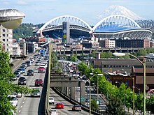
At the north end of the bridge, SR 99 turns northwest onto East Marginal Way South and travels through Seattle's industrial neighborhood along the east bank of the Duwamish Waterway. The six-lane street turns north and passes a cement factory before transforming into a four-lane freeway at an interchange with the West Seattle Freeway on the east end of the West Seattle Bridge. SR 99 widens to six lanes, including a northbound bus lane, and passes through the SoDo neighborhood as the dividing line between the Port of Seattle's container ship terminals to the west and industrial businesses to the east beyond a rail terminal. The freeway passes the corporate headquarters of Starbucks and Coast Guard Station Seattle before turning northeast and reaching the southern portal of the Alaskan Way Tunnel near Lumen Field and T-Mobile Park.[12] The tunnel entrance includes offramps to nearby streets, including Dearborn Street, Alaskan Way, and a frontage road along the east side of the highway.[14]
The tunnel travels 1.8 miles (2.9 km) under Downtown Seattle and carries SR 99 along the central waterfront, running roughly parallel to the former Alaskan Way Viaduct. It is arranged with two stacked decks, carrying two lanes of southbound traffic on the upper deck and two lanes of northbound traffic on the lower deck.[15] SR 99 emerges from the tunnel on the north side of Denny Way and travels onto Aurora Avenue North through the South Lake Union neighborhood, located to the east of the Seattle Center and the Space Needle.[16] Aurora Avenue continues north as a six-lane street with bus lanes and a median barrier that restricts access from side streets to right-in/right-out. The highway runs along the eastern slope of Queen Anne Hill, above the Westlake neighborhood along Lake Union, to the Lake Washington Ship Canal.[9][12]

Aurora Avenue then crosses the ship canal on the George Washington Memorial Bridge (commonly known as the Aurora Bridge), a steel cantilever arch bridge with a clearance of 167 feet (51 m).[17] The bridge has six lanes and no median barrier, which resumes after an interchange with Bridge Way on the north approach, which crosses over the Fremont Troll.[18] The highway continues north through part of Fremont and intersects North 46th Street before entering Woodland Park. SR 99 forms the boundary between Woodland Park to the east and the Woodland Park Zoo to the west and passes under a series of three pedestrian overpasses.[19] The highway turns northeast to follow the shore of Green Lake and passes through the residential districts of Phinney Ridge and Greenwood, where traffic signals replace the medians and right-in/right-out access. SR 99 passes west of the North Seattle College campus in Licton Springs and intersects Northgate Way, a major street that provides access to Northgate Mall. Aurora Avenue then bisects the Evergreen Washelli Memorial Park, the city's largest cemetery,[20] and passes between Haller Lake and Bitter Lake before reaching the northern city boundary at North 145th Street (SR 523).[9][12]
Shoreline and Snohomish County[]
SR 99 enters Shoreline and passes through the city's main commercial district, running parallel to the Interurban Trail.[21] The stretch of Aurora Avenue through Shoreline has a landscaped median, plant buffers for sidewalks, several left-turn pockets, and an overpass for the Interurban Trail.[22] Near Shorewood High School and the Shoreline city hall, the highway is flanked to the east by the Interurban Trail and a park with a preserved section of the original North Trunk Road, which was paved in red bricks.[23] After passing Echo Lake and the Aurora Village shopping center, SR 99 reaches an interchange with SR 104 near the boundary between King and Snohomish counties. The highway intersects SR 104 Spur on the county line itself, which lies south of the interchange.[12]
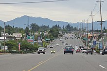
After the interchange, the highway turns northeast and runs through a predominantly commercial area of Edmonds, passing east of the Swedish Medical Center's Edmonds campus and west of Hall Creek and the Interurban Trail. SR 99 continues northeast into Lynnwood and passes the Edmonds College campus before reaching the Crossroads commercial district at a junction with 196th Street Southwest (SR 524).[24] The highway runs along the city's retail strip and through its international district (also described as a Koreatown),[25] which is surrounded by apartments and homes that are setback from SR 99.[12]
Beyond the city limits of Lynnwood, SR 99 enters an unincorporated area near Lake Serene. The highway intersects SR 525 at a partial cloverleaf interchange and crosses Airport Road, which provides access to Paine Field and its passenger terminal. The highway travels north into Everett on Evergreen Way and turns northeast onto Everett Mall Way in the Fairmont neighborhood. SR 99 then passes through several residential subdivisions and reaches the Everett Mall, where it turns north and terminates at the Broadway Interchange. The interchange includes connections to I-5, the Boeing Freeway (SR 526), and SR 527. The road itself continues north towards Downtown Everett as Broadway.[12]
History[]
Pacific Highway and U.S. Route 99[]
SR 99 was created from the remnants of US 99, a national highway which spanned Western Washington from the Oregon border in Vancouver to the Canadian border at the Peace Arch in Blaine. US 99 itself was preceded by a century-old network of military roads, wagon roads, and auto trails that were built across the state in the 19th century and early 20th century until it was formally incorporated into the state highway system.[26]
In southern King County, modern-day SR 99 runs parallel to a section of the Fort Steilacoom–Fort Bellingham military road, constructed in the 1850s by the U.S. Army.[27][28] A section north of Seattle follows the R.F. Morrow wagon road, constructed in 1901 and later incorporated into the North Trunk Road.[29] The North Trunk Road was completed from Seattle to the area east of Edmonds in August 1912 and initially paved with bricks.[30] An interurban railway was also built along sections of the wagon road in 1906 and would serve Everett–Seattle traffic until 1939.[31]
The Pacific Highway, an inter-state coastal highway, was championed by good roads advocates in the early 1910s and added to the state highway system in 1913.[32][33] It originally followed the Puyallup and Green rivers from Tacoma to Renton and the Bothell–Everett Highway (now SR 527) along North Creek in Snohomish County.[33][34] The highway was designated as State Road 1 in 1923,[35] a number that it would retain after the creation of Primary State Highway 1 (PSH 1) in 1937.[36] The Pacific Highway was incorporated into the new national numbered highway system in 1926 as US 99, connecting the three West Coast states and running from the Mexican border to Canada.[37] The Bothell route was bypassed by a newer and straighter highway to the west that opened on October 9, 1927.[38] It was built by the state government in tandem with a set of new bridges connecting Everett to Marysville and cost $645,000 (equivalent to $7.76 million in 2019 dollars)[39] to construct and partially pave.[40] The White River route was bypassed in early 1928 by the 24-mile-long (39 km) Highline route, which traveled along the western plateau near Des Moines.[41][42] The new highway cost $3 million (equivalent to $35.8 million in 2019 dollars)[39] to construct and pave and reduced the distance to Tacoma by 9.3 miles (15.0 km).[43][44]
US 99 was originally routed north from Downtown Seattle on 4th Avenue, Westlake Avenue, 7th Avenue, and Dexter Avenue, crossing the Lake Washington Ship Canal on the Fremont Bridge before continuing onto Fremont Avenue.[45] A high-level crossing of the Ship Canal to replace the existing drawbridges was proposed in the 1920s as the "final link" in the Pacific Highway.[46][47] The 132-foot-high (40 m) bridge was funded by the state, county, and municipal governments and approved for construction in 1927.[48][49] Construction on the bridge began in 1929 and was completed on February 22, 1932, during a dedication ceremony that named it the George Washington Memorial Bridge.[50] The bridge was sited on Aurora Avenue, which was expanded into a limited-access expressway that extended south to Denny Way and north through Woodland Park to North 65th Street.[51][52] The expressway on the north side of the bridge was completed in May 1933 after a public debate over its routing through Woodland Park, which was opposed by The Seattle Times and conservationists.[53][54] The debate was settled after the passing of a city council ordinance in June 1930 and a ballot measure in November that approved the through-park route.[55]
Viaduct and expressway construction[]

Within Downtown Seattle, US 99 was routed along 4th Avenue, connecting to the north with the Aurora Avenue expressway via 7th Avenue and to the south with East Marginal Way near Boeing Field.[56][57] An was designated in the early 1950s along 1st Avenue, rejoining the highway in Georgetown.[56] Congestion and difficulty in directing freight trucks through downtown led to proposals for a bypass route for US 99 as early as 1928 along Railroad Avenue on the city's waterfront.[51] Railroad Avenue, later renamed Alaskan Way, was rebuilt in the 1930s as part of the federal government's improvements to the city seawall and became the primary bypass route for through traffic, experiencing major congestion as a result.[51]
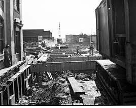
Formal proposals to build "motor viaducts" bypassing the city along Alaskan Way were submitted by the city engineering department in 1937 and supported by automobile and traffic safety groups.[58][59] The bypass viaduct gained popularity following the end of World War II and engineering work was approved in 1947, with construction funds sourced from the city and the Federal-Aid Highway Act of 1944.[60] A double-deck elevated design was chosen to accommodate the six lanes that would displace railroads along the east side of Alaskan Way.[60][61] Construction on the Alaskan Way Viaduct began on February 6, 1950, and the first section between Railroad Way and Elliott Avenue opened to traffic on April 4, 1953.[62][63] It cost approximately $8 million to construct (equivalent to $62.2 million in 2019 dollars),[39] using pile-driven columns and a pair of moving gantry cranes to lift sections of the roadway from street level.[63][64]
The Battery Street Tunnel, connecting the viaduct with the Aurora Avenue expressway, was opened to traffic on July 24, 1954, and cost $2.8 million to construct (equivalent to $21.6 million in 2019 dollars).[39][65] A 2.3-mile (3.7 km) extension of the viaduct, linking south to a surface freeway and US 99 at East Marginal Way, cost $7.6 million to construct (equivalent to $58.6 million in 2019 dollars)[39] and opened on September 3, 1959.[66] The southern extension eased congestion at the Railroad Way terminus and was used by a daily average of 25,000 vehicles within days of opening and 37,000 vehicles by the end of the year.[62][67] A series of ramps connecting the viaduct to the Spokane Street Viaduct were completed in January 1960,[68] followed by a downtown offramp to Seneca Street in November 1961 and onramp from Columbia Street in February 1966.[69][70] The state government had prepared to build a set of ramps from the viaduct to US 10 (later part of I-90) near Connecticut Street,[71] but plans for the freeway were delayed in the 1960s and eventually abandoned,[72][73] leaving the ramps unused.[74][75]
The viaduct was initially signed as part of U.S. Route 99 Alternate and US 99 Bypass until 1959, when US 99 was formally switched to the viaduct after the completion of the southern extension.[76][77] 4th Avenue was signed as a business route of US 99 and also carried a section of US 10 to its terminus at the north end of the Battery Street Tunnel.[78] The East Marginal Way route through the Boeing Field area was heavily congested due to traffic heading to Boeing facilities, leading to proposals in the 1950s to build a new expressway on the west side of the Duwamish River.[79] Construction of the two-lane West Marginal Way expressway began in November 1958 and was completed in July 1959, including grade-separated interchanges and bridges at South 118th Street, 14th Avenue South, and South Cloverdale Street.[80] The expressway split from US 99 at South 118th Street and connected to 1st Avenue at the south end of the viaduct using the First Avenue South Bridge, which opened in 1956 with the intent of becoming part of US 99.[81] In March 1959, the state government approved $3 million in funds (equivalent to $20.5 million in 2019 dollars)[39] for an expansion project that would widen the West Marginal Way expressway to four lanes.[82] The expansion was completed in 1968,[83][84] and was signed as US 99 Temporary and later State Route 99T after the 1964 state highway renumbering.[85]
Replacement and redesignation[]

The state legislature authorized planning of a tolled expressway from Tacoma to Everett in 1953, with the intent of building a grade-separated bypass of US 99.[86][87] The tollway plan was superseded three years later by the Interstate Highway Program, which was authorized by the federal government and included a north–south freeway through the Seattle area replacing US 99.[88] The route was designated as Interstate 5 in 1957 and planning for the Seattle Freeway began at the same time using federal funds.[89][90]
The first section of the Tacoma–Seattle–Everett freeway to be built was in southern Tacoma and was opened to traffic in October 1959. The Tacoma sections opened in October 1962 from the Puyallup River to the Kent–Des Moines Road (now SR 516) in Midway,[91] and in October 1964 in downtown Tacoma.[92] Construction of the Seattle section began in 1958 with work on the Ship Canal Bridge, which was opened to traffic on December 18, 1962.[93] The northern approach to Downtown Seattle was opened the following August to coincide with the completion of the Evergreen Point Floating Bridge and SR 520.[94] A 20-mile (32 km) section of the freeway traveling from North Seattle to southern Snohomish County and Everett was opened to traffic on February 3, 1965.[95] The freeway connecting Midway to the south side of Downtown Seattle was opened on January 31, 1967, completing the final section of the urban freeway.[96] I-5 itself was completed two years later with the opening of the section between Everett and Marysville on May 14, 1969.[97]
The state government introduced a new highway numbering system in 1964 to align with the Interstates and prepare for the decommissioning of U.S. routes.[98] PSH 1 was replaced with US 99, which remained as a temporary designation on various freeway sections until I-5 was fully completed.[85][99] US 99 was decommissioned at a meeting of the American Association of State Highway Officials on June 24, 1969, shortly after the full completion of I-5 within Washington state.[100] While most US 99 signs were removed, an overhead sign in Downtown Seattle at the Columbia Street onramp to the Alaskan Way Viaduct remained until the viaduct was demolished in 2019.[101]
During the 1970 codification of the new highway system, the state legislature created State Route 99 (SR 99) to delay transferring ownership and maintenance of the highway to local jurisdictions.[102][103] SR 99 was created from a section of US 99 running from Fife to the Broadway Interchange in Everett,[102] and was retained as a permanent addition to the state highway system in 1971 due to the corridor's importance to state affairs.[104][105] A provision in the 1971 law allows for the abandonment of the Fife–Federal Way section of SR 99 after the completion of the SR 509 freeway extension.[104] Instead of continuing north into Everett on Evergreen Way, SR 99 was routed northeasterly on Everett Mall Way, a section of the Broadway Cut-off (also named Diagonal Way) that opened in 1954.[105][106]
Street and bridge improvements[]

Sections of SR 99 in North Seattle along Aurora Avenue and in South King County declined economically after the opening of Interstate 5, losing businesses amid increased crime.[107] It became a notorious haven for drug dealers, prostitutes, the homeless, and strip clubs by the 1970s and 1980s.[108][109] The 17-mile (27 km) stretch from Federal Way to Tukwila in South King County, popularly known as the "SeaTac Strip", was where the Green River Killer (Gary Ridgway) picked up many of his victims in the 1980s.[110][111][112] The highway was also unsafe for pedestrians and cross-traffic due to the lack of crossings and improper management of utility lines and overgrown foliage.[107]
In an effort to clean up sections of the corridor, various cities have undertaken reconstruction projects in the 1990s and 2000s to turn the highway into a landscaped boulevard.[107][113] In southern King County, the cities of Federal Way, SeaTac, and Tukwila drew up redevelopment plans that were largely built out in the 2000s, reducing traffic collisions and crime while improving the area's appearance.[107] After being denied permission to plant trees along SR 99, the city of Tukwila requested control of the highway within its city limits and was granted a jurisdictional transfer in 2004 by the state legislature, allowing them to redevelop 2.4 miles (3.9 km) of International Boulevard into a new street with traffic calming features.[11][114]
The city of Shoreline was incorporated in 1995 and made the redevelopment of Aurora Avenue into an early priority, completing its $140 million modernization and multi-use trail project in stages between 2008 and 2017.[115] The project included new traffic signals, BAT lanes, underground utility lines, and two pedestrian bridges.[116] Edmonds plans to add widened sidewalks with planted buffer zones, new crosswalks, and turn lane pockets to its 2.5-mile (4.0 km) section of SR 99 beginning in 2022.[117][118] The city of Seattle also plans to improve its section of Aurora Avenue North, but funding shortages and the timing of WSDOT repaving projects have led to a lack of sidewalks along some sections of the street.[119][120]
The Aurora Bridge, part of the expressway linking Aurora Avenue to downtown Seattle, was the site of frequent suicide jumps until a set of emergency phones and new fences were installed in 2011 at a cost of $4.6 million to deter would-be jumpers.[121][122] The bridge and its expansion joints underwent a major seismic retrofit that was completed in 2012 at a cost of $5.7 million;[123] the retrofit was followed by a repainting and repaving project that was completed in two stages between 2016 and 2018 at a cost of $35 million.[124][125] On September 24, 2015, a collision between an amphibious Duck tour vehicle and a charter bus on the Aurora Bridge killed four people and injured 50 more.[126] The incident raised questions regarding the safety of Aurora Bridge, which lacks a median barrier and is the narrowest six-lane bridge in the state, with a lane width of 9.5 feet (2.9 m).[127] Other sections of Aurora Avenue were retrofitted to install median barriers in 1973,[128] and the state government considered a 2003 plan to put barriers on the bridge and relocate the sidewalks to compensate for the additional weight but ultimately deferred any improvements.[127] In the aftermath of the crash and its three-year-long court case, WSDOT and the Seattle Department of Transportation have disagreed over whether to install a center barrier or median zipper system, and which agency would be responsible for funding either option.[18]
Viaduct replacement and tunnel project[]
Proposals and earthquake studies[]

Proposals to replace the Alaskan Way Viaduct date back to the 1970s during attempts to revitalize the city's waterfront for tourism and recreation rather than traditional industrial uses.[129] A similar double-decker freeway, the Cypress Street Viaduct in Oakland, California, collapsed during the Loma Prieta earthquake in 1989 and killed 42 people, leading to intensified calls to replace the viaduct due to the realized earthquake risk.[130] A 1995 study commissioned by the state government after the Kobe earthquake found vulnerabilities in the Alaskan Way Viaduct's design that could cause severe damage and collapse during a major earthquake, along with liquefaction risks due to the underlying reclaimed land that the highway was built on.[131][132] The study estimated that it would cost $118 million (equivalent to $170 million in 2019 dollars) to demolish the viaduct, $344 million (equivalent to $495 million in 2019 dollars) to retrofit the structure for earthquake resistance, and $530 million (equivalent to $763 million in 2019 dollars) to build a new elevated freeway to replace it;[39][133] other options included replacing the freeway with a tunnel or a surface boulevard with public transit on Alaskan Way, similar to San Francisco's Embarcadero.[134][135]
On February 28, 2001, the Nisqually earthquake struck the Seattle area with strong shaking that caused signs of visible damage on the Alaskan Way Viaduct.[136] The freeway was shut down for inspections, which found small cracks and other minor damage to non-structural elements that allowed it to reopen within 26 hours.[137] Four more closures were ordered later in March and April due to pieces of concrete dropping onto the streets below, requiring emergency repairs to add steel rods to reinforce the columns.[138][139] The first repairs were completed in November at a cost of $1.8 million and a set of new vehicle weight restrictions were implemented;[140] in total, $14.5 million was spent on various repairs due to earthquake damage.[141] Annual inspections and continued monitoring found that the earthquake had caused settling of up to 4 inches (10 cm) into the soil and weakened connections between the columns and highway decks.[129][142] Additional investigations also found unrelated damage to the underlying seawall, which would need to be rebuilt to prevent a resulting collapse of the viaduct.[129][143]
An ongoing state study investigating a viaduct replacement strategy was accelerated by the state legislature using $5 million in funds,[144] while a separate engineering study suggested immediate demolition of the structure due to a 1-in-20 chance of collapse in an earthquake within the next decade.[145][146] In late 2001, WSDOT began work on an environmental impact statement (EIS) for the viaduct replacement project using emergency funds from the state legislature and consulted the city government and community leaders to generate concepts.[147] By the following year, a set of 76 concepts organized into four general alternatives were presented for public feedback.[148] Among the options were an elevated freeway similar to the current viaduct and several tunnel concepts, including a bored tunnel, a two-level cut-and-cover tunnel, and a mined tunnel carrying one direction of traffic.[149] Five finalist options were paired with the seawall replacement and evaluated in June 2002, with costs ranging from $3.5 billion for a rebuilt viaduct to $8.8–$11.6 billion for various tunnel designs.[150]
Tunnel concept, advisory votes, and subprojects[]

The tunnel plan was endorsed by WSDOT and the city council based on public support for waterfront revitalization, but design changes would be needed to bring down its cost.[151][152] After voters rejected a statewide gas tax referendum that would have funded a portion of the project's cost, WSDOT and the city government drafted new cost-saving concepts for a shorter tunnel and a surface boulevard that were included in the five options evaluated by the draft EIS in 2004.[153][154] The six-lane, $4 billion tunnel option was chosen as the preferred alternative by WSDOT in late 2004, despite backlash from activists groups who favored a rebuilt viaduct or a waterfront boulevard.[155]
The state legislature passed an $8.5 billion gas tax program in 2005, allocating $2 billion in funding for the viaduct replacement.[156] A supplemental EIS was prepared in 2006 to include new project requirements for the Battery Street Tunnel area and evaluate the cut-and-cover tunnel and elevated options.[129] A pair of advisory, non-binding ballot measures was held in March 2007 to find a consensus between the $2.8 billion elevated replacement supported by Governor Christine Gregoire and a smaller four-lane tunnel with surface public transit improvements that would cost $3.4 billion and was supported by Mayor Greg Nickels; Nickel's "hybrid tunnel" proposal was rejected by Gregoire and state legislators prior to the vote based on operational and safety problems identified by WSDOT.[157][158] Both options were rejected by voters, with 70 percent opposed to the tunnel and 55 percent opposed to the elevated concept.[159]
The governments of Washington state, King County, and Seattle agreed to re-evaluate the planning process for the viaduct replacement and split the main proposals from essential safety and traffic improvements that would be included in all alternatives.[129] A $915 million package of projects was approved for immediate construction, beginning with work to strengthen sinking columns in late 2007 and repairs to the Battery Street Tunnel the following year.[160][161] Although the column strengthening project was declared successful, further inspections found that the Columbia Street onramp had sunk an additional 1⁄8 inch (0.32 cm) during the nearby construction.[162][163] The southernmost stretch of the viaduct, between Holgate and King streets, was demolished in October 2011 and replaced with a six-lane elevated freeway that opened the following year at a cost of $115 million.[164][165] Seattle voters approved a bond measure in 2012 to replace the Alaskan Way Seawall;[166] the project began construction in 2013 and was completed in 2017 at a cost of $410 million, running 21 percent overbudget.[167][168]
Deep-bored tunnel approved and contested[]
The state government announced a new timeline for the project in January 2008, with Governor Gregoire declaring her intention to demolish the viaduct by 2012 regardless of Seattle's approval.[169] Eight new concepts for a four-lane replacement were developed by June from a set of priorities developed for SR 99, I-5, and public transit in downtown.[170] The eight options included two surface boulevards with transit improvements, a one-way couplet, a set of two elevated freeways, an elevated freeway with a rooftop park, and three tunnels: a cut-and-cover tunnel, a lidded trench, and a deep-bored tunnel.[171] Several early concepts, including a bridge across Elliott Bay and a complete rebuild of the double-decked viaduct, were rejected by the panel of public officials.[172] The final decision was delayed until after the gubernatorial election, but would have to meet an end-of-year deadline imposed by the state legislature.[173] In December 2008, two finalists were chosen for further study and consideration by the state legislature: a $2.3 billion elevated freeway and the $2.2 billion surface-transit option.[174]
While the deep-bored tunnel was not chosen as one of the two finalists, it remained popular with tunnel activists and was considered separately due to its $4.25 billion cost (equivalent to $5.03 billion in 2019 dollars).[39][175] On January 13, 2009, Governor Gregoire signed an agreement with Mayor Nickels and King County Executive Ron Sims to ratify the deep-bored tunnel as the replacement for the Alaskan Way Viaduct, to be completed by 2015. $2.8 billion would be covered by state gas taxes and federal funds, leaving a $1.4 billion shortfall to be filled by the local government and potential tolls.[176][177] The state legislature passed a bill in April 2009 to commit $2.8 billion in state funding for the tunnel project, which Governor Gregoire signed the following month.[178][179] In total, more than 90 alternatives were considered before the final agreement was reached in 2009.[180]
The tunnel project received $300 million in funds from the Port of Seattle in exchange for design input on the surface boulevard that would replace Alaskan Way.[129] Neighborhood and environmental activist Mike McGinn was elected mayor in 2009, largely on an anti-tunnel platform, and threatened to veto project agreements until the state took responsibility for cost overruns that would fall upon Seattle.[181][182] The city council approved a non-binding resolution to authorize the tunnel project, pending the outcome of contract bidding, which was completed in December 2010 with the selection of Seattle Tunnel Partners (STP), a consortium led by Dragados USA.[183] STP presented a $1.09 billion plan to use a 58-foot-diameter (18 m) tunnel boring machine, the world's widest, to complete the tunnel by late 2015.[184] WSDOT signed the tunnel construction contract in January 2011, sending a set of contractor agreements to the city council for approval.[185]
The state's agreements were approved by the city council in February 2011, shortly before being symbolically vetoed by Mayor McGinn; the veto was overridden by the end of the month—the 10th anniversary of the Nisqually earthquake—with an 8–1 city council majority.[186][187] McGinn joined other tunnel opposition groups to file a referendum questioning whether the city council had the authority to approve the state and federal agreements.[181][188] The referendum was initially blocked by a lawsuit filed by the city, but was approved and placed on the August 2011 ballot by a county judge.[189] The referendum was approved by 58 percent of voters on August 16, 2011, authorizing the city's agreements with WSDOT.[129][190] The Federal Highway Administration completed its analysis of the project's final EIS and issued its record of decision with WSDOT later that month, allowing pre-construction activities to begin.[191]
Tunnel boring and viaduct closure[]

After the demolition of the viaduct's southernmost stretch and its lanes were realigned onto an adjacent bypass in 2012, crews began excavation of a 420-foot-long (130 m) launch pit to house the tunnel boring machine.[192] Local officials, with the notable absence of Mayor Mike McGinn, participated in a ceremonial groundbreaking was held for the tunnel on June 20, 2012.[193] The 57-foot (17 m) tunnel boring machine was manufactured by Hitachi Zosen in Osaka, Japan, and named "Bertha" in honor of Mayor Bertha Knight Landes.[194] Bertha arrived in Seattle on April 2, 2013, and its 40 pieces were assembled in the launch pit before tunnel boring began on July 30—setting a record for the world's largest tunnel boring machine.[194][195]
Tunnel boring was halted at 1,028 feet (313 m) near South Main Street in December 2013 after the machine encountered an unknown object that caused it to overheat.[196] The object was found to be a 119-foot (36 m) steel pipe and well casing that was left behind by a groundwater research crew for the project in 2002.[197] The pipe caused extensive damage to Bertha's cutterhead and main bearing seal, requiring the excavation of a 120-foot (37 m) rescue pit for repairs.[198] Bertha reached the completed excavation pit in March 2015 and the machine's front end was disassembled and lifted to the surface to repair the damage, which was found to be more extensive than previously thought.[199][200]
The repaired cutterhead was lowered into the access pit in August 2015 and tunnel boring resumed on December 22, 2015, reaching past the pit the following month.[201][202] During the two-year halt in tunnel boring, public officials considered alternative plans to accelerate demolition of the viaduct while awaiting tunnel completion.[203] The project was named one of the worst boondoggles in the United States by several transportation groups and critics, due in part to the stoppage and its high cost.[204] Tunnel boring was halted by Governor Jay Inslee in January 2016 due to the appearance of a sinkhole in Pioneer Square, but resumed the following month.[205] The machine passed under the Alaskan Way Viaduct in April 2016, requiring a closure while the structure was monitored for movement, and reached the halfway mark in October.[206][207] Bertha completed its 1.75-mile (2.82 km) bore on April 4, 2017, arriving at the north portal near Aurora Avenue for disassembly, which was completed in August.[208][209] The tunnel portals and their maintenance areas were completed while work on the double-decker freeway inside the tunnel progressed behind the machine.[210]
The Alaskan Way Viaduct permanently closed on January 11, 2019, beginning a three-week realignment of ramps at the portals as ramps were prepared for the opening of the tolled downtown tunnel on February 4, 2019.[211][212] The remaining 1.4-mile (2.3 km) section of the viaduct was demolished in stages between February and November 2019, with some of the 240 million pounds (110,000,000 kg) of rubble deposited into the Battery Street Tunnel as it was filled and sealed.[213][214] A three-block section of Aurora Avenue between Denny Way and the new tunnel portal was raised and reconnected to cross-streets in 2019.[214][215] The Alaskan Way promenade and boulevard project is planned to cost $668 million and will be completed in 2024.[216] The new boulevard will be eight lanes wide in some sections due to requirements placed by WSDOT for Colman Dock access and the Port of Seattle for truck access.[217] The viaduct replacement megaproject is estimated to cost $3.3 billion, with $200 million of construction costs and additional funds for ongoing maintenance to be raised through tunnel tolls that began to be collected on November 9, 2019.[15][218]
Names and designations[]

The name of SR 99 differs from city to city, with several sections named the Pacific Highway and International Boulevard, a moniker invented by SeaTac for the 1990 Goodwill Games hosted by King County.[219] In Seattle, the highway is known as East Marginal Way and Aurora Avenue North; in Everett, it uses Evergreen Way and Everett Mall Way.[220][221] A four-block section of former SR 99 between Denny Way and the new tunnel portal was renamed to 7th Avenue North and Borealis Avenue in early 2019 as part of the reconfiguration of Aurora Avenue.[222]
The United Daughters of the Confederacy unsuccessfully lobbied the state legislature in 1939 to designate the entirety of US 99 within the state as part of the national "Jefferson Davis Highway".[223][224] A pair of granite markers were installed the following year in Blaine and Vancouver to commemorate the highway, allegedly to recognize Davis's contributions to the territorial development of Washington as U.S. Secretary of War.[225] The two markers were removed in 1998 and 2002, and are now located at the privately owned Jefferson Davis Park in Ridgefield.[226]
The State House of Representatives unanimously approved a bill in 2002 that would have removed Davis' name from the road, but it was deferred by a State Senate committee.[227] The attempted renaming, led by Snohomish representative Hans Dunshee, generated political controversy and death threats against legislators from people opposed to the bill.[223] The bill was revived in May 2016 and was passed unanimously by both houses of the legislature, renaming SR 99 for William P. Stewart, an African-American Civil War veteran and early settler in Snohomish.[228] New highway signs for the William P. Stewart Memorial Highway were installed the following year, amid a new wave of Confederate monument removals.[229]
Public transit[]
![A red-and-yellow articulated bus seen on a suburban street from a nearby sidewalk. The bus's front sign reads "[A] Federal Way TC".](http://upload.wikimedia.org/wikipedia/commons/thumb/2/21/RapidRide_A_Line_to_FWTC_Test_Coach.jpg/220px-RapidRide_A_Line_to_FWTC_Test_Coach.jpg)
SR 99 is a major regional public transit corridor and carries several bus rapid transit routes and a light rail line in SeaTac.[230] The highway features bus lanes and business access and transit lanes (BAT lanes) in several locations to give buses traffic priority while retaining access to right turns.[231][232]
Pierce Transit route 500 runs on the SR 99 and Pacific Highway corridor between Tacoma Dome Station and Federal Way Transit Center.[230] Through Federal Way and SeaTac, the highway is served by the RapidRide A Line, an 11-mile (18 km) rapid bus route that debuted in 2010 and features enhanced bus stops and transit signal priority.[233] Sound Transit's Link light rail trains on Line 1 run along elevated tracks above or near SR 99 from Angle Lake station to Tukwila International Boulevard station at the SR 518 interchange.[230][234] The Alaskan Way Viaduct carried several non-stop routes connecting Downtown Seattle to West Seattle (including the RapidRide C Line) and Burien.[230][235]
Aurora Avenue is served by the RapidRide E Line, which carried 18,000 passengers daily in 2017 and is the busiest bus route in the King County Metro system.[236] The E Line debuted in 2014, replacing Route 358—itself the successor to Route 359, which was retired in 1999 after a Metro bus was involved in a shooting and crashed off the Aurora Bridge.[237][238][239] The E Line terminates in Downtown Seattle and near the county line at the Aurora Village Transit Center, where Community Transit's route 101 and Swift Blue Line begins. Swift features off-board fare payment and longer spacing between stops, and runs from Shoreline to Everett Station via Evergreen Way.[240][241] The Everett Mall Way section of SR 99 is served by Everett Transit route 7, which connects the Everett Mall to Downtown Everett and Everett Station.[230][242]
Major intersections[]
| County | Location | mi[1] | km | Destinations | Notes | ||
|---|---|---|---|---|---|---|---|
| Pierce | Fife | 0.00 | 0.00 | ||||
| Milton | 1.62 | 2.61 | Porter Way | Former SR 514 | |||
| King | Federal Way | 4.49 | 7.23 | ||||
| 7.72 | 12.42 | South end of SR 509 concurrency | |||||
| Des Moines | 11.84 | 19.05 | North end of SR 509 concurrency | ||||
| SeaTac | 15.11 | 24.32 | |||||
| SeaTac–Tukwila city line | 16.78 | 27.00 | Interchange | ||||
| Gap in route, continues as Tukwila International Boulevard | |||||||
| Tukwila | 16.79 | 27.02 | Continuation south | ||||
| South 116th Street / Tukwila International Boulevard | Interchange; south end of freeway section | ||||||
| 17.61 | 28.34 | West Marginal Place South | Northbound exit and entrance | ||||
| Seattle | 18.63 | 29.98 | Des Moines Memorial Drive / 14th Avenue South | ||||
| 19.22 | 30.93 | South Cloverdale Street | Northbound entrance only | ||||
| 19.56 | 31.48 | South Kenyon Street – South Park | Southbound exit and entrance | ||||
| 20.23 | 32.56 | Interchange | |||||
| Duwamish River | 20.27– 20.82 | 32.62– 33.51 | First Avenue South Bridge | ||||
| Seattle | 20.60 | 33.15 | Northbound exit and southbound entrance | ||||
| North end of freeway | |||||||
| 22.41 | 36.07 | Spokane Street – West Seattle, Waterfront, Port Terminals | Northbound exit and southbound entrance | ||||
| South end of freeway | |||||||
| 22.80 | 36.69 | West Seattle Bridge – Harbor Island | Southbound exit and northbound entrance | ||||
| 23.96 | 38.56 | Southbound exit and northbound entrance | |||||
| 24.18– 26.26 | 38.91– 42.26 | Alaskan Way (SR 99) Tunnel | |||||
| 26.18 | 42.13 | Republican Street, 6th Avenue North – Mercer Street, Seattle Center | Northbound exit and southbound entrance | ||||
| 26.44 | 42.55 | Aurora Avenue – Denny Way, Downtown Seattle | Southbound exit and northbound entrance; north end of freeway | ||||
| Lake Union | 27.75– 28.31 | 44.66– 45.56 | George Washington Memorial Bridge | ||||
| Seattle | 28.43 | 45.75 | North 38th Street | Interchange | |||
| 29.05 | 46.75 | North 46th Street | Interchange | ||||
| 29.88 | 48.09 | North 63rd Street / Green Lake Way | Interchange | ||||
| Seattle–Shoreline city line | 34.05 | 54.80 | |||||
| King–Snohomish county line | Shoreline–Edmonds city line | 37.07 | 59.66 | ||||
| Snohomish | Edmonds | 37.18 | 59.84 | Interchange | |||
| Lynnwood | 40.42 | 65.05 | |||||
| | 44.20 | 71.13 | Interchange | ||||
| Everett | 48.80– 48.97 | 78.54– 78.81 | |||||
| 48.97 | 78.81 | Continues north as Broadway | |||||
1.000 mi = 1.609 km; 1.000 km = 0.621 mi
| |||||||
References[]
- ^ a b c Multimodal Planning Division (February 4, 2020). State Highway Log Planning Report 2019, SR 2 to SR 971 (PDF) (Report). Washington State Department of Transportation. pp. 771–803. Retrieved May 16, 2020.
- ^ a b Muhlstein, Julie (May 21, 2016). "Highway 99 renamed in honor of Snohomish settler William P. Stewart". The Everett Herald. Retrieved September 18, 2018.
- ^ "State Highway National Highway System Routes in Washington" (PDF). Washington State Department of Transportation. 2017. Retrieved September 18, 2018.
- ^ "What is the National Highway System?". Federal Highway Administration. January 31, 2017. Retrieved September 18, 2018.
- ^ "Transportation Commission List of Highways of Statewide Significance" (PDF). Washington State Transportation Commission. July 26, 2009. Retrieved September 18, 2018.
- ^ 2016 Annual Traffic Report (PDF) (Report). Washington State Department of Transportation. 2017. pp. 126–128. Retrieved September 18, 2018.
- ^ McDonalds, Cathy (December 24, 2009). "History and a rare peat bog at West Hylebos Wetlands Park". The Seattle Times. p. D6. Retrieved September 18, 2018.
- ^ a b c Google (September 25, 2017). "State Route 99 (southern segment)" (Map). Google Maps. Google. Retrieved September 25, 2017.
- ^ a b c d e Washington State Department of Transportation (2014). Washington State Highways, 2014–2015 (PDF) (Map). Olympia, Washington: Washington State Department of Transportation. Puget Sound inset. Retrieved September 25, 2017.
- ^ Allmain, Greg (April 14, 2012). "Federal Way celebrates Pacific Highway project". Federal Way Mirror. Retrieved December 18, 2018.
- ^ a b "House Bill Report: SB 5376" (PDF). Washington State Legislature. March 1, 2004. Retrieved September 18, 2018.
- ^ a b c d e f g Google (February 4, 2019). "State Route 99 (northern segment)" (Map). Google Maps. Google. Retrieved February 4, 2019.
- ^ Beers, Carole (February 2, 1997). "New Duwamish span opens while old one is fixed". The Seattle Times. p. B1.
- ^ "Traveling on the new SR 99 corridor" (PDF). Washington State Department of Transportation. January 2017. Retrieved February 4, 2019.
- ^ a b Lindblom, Mike (November 19, 2018). "When does the viaduct close? How much is the tunnel toll? Your guide to Seattle's Highway 99 project". The Seattle Times. Retrieved December 23, 2018.
- ^ Lindblom, Mike; Baruchman, Michelle (January 31, 2019). "Highway 99 tunnel opens next week. Here are answers to your questions about the project". The Seattle Times. Retrieved January 31, 2019.
- ^ Beason, Tyrone (November 25, 2015). "Seattle's gritty bridges are built for function, not beauty". The Seattle Times. Retrieved September 18, 2018.
- ^ a b Lindblom, Mike (June 19, 2018). "Can a 'zipper' eliminate the squeeze?". The Seattle Times. p. A1. Retrieved December 21, 2018.
- ^ Dorpat, Paul (December 26, 2008). "Pedestrian overpass on Seattle's busy Aurora Avenue saves lives". The Seattle Times. Retrieved September 18, 2018.
- ^ Broom, Jack (May 25, 1986). "The land of the hereafter: A cemetery has a life of its own". The Seattle Times. p. 12.
- ^ Bock, Paula (December 9, 2007). "On the edge of opportunity: A community stretches for the buzz". The Seattle Times. p. 12. Retrieved September 18, 2018.
- ^ Salyer, Sharon (August 28, 2017). "Edmonds has big plans for its Highway 99 improvements". The Everett Herald. Retrieved September 18, 2018.
- ^ Smith, Evan (April 14, 2009). "A compromise for the 'Red Brick Road'". The Everett Herald. Retrieved September 18, 2018.
- ^ Watkins, Amy (October 29, 2013). "New shopping center opens in Lynnwood". The Everett Herald. Retrieved September 18, 2018.
- ^ Kugiya, Hugo (May 5, 2011). "Bibimbap's on the map in Koreatown North". Crosscut.com. Retrieved September 18, 2018.
- ^ Flood, Chuck (2013). Washington's Highway 99. Charleston, South Carolina: Arcadia Publishing. p. 8. ISBN 978-0-7385-9618-1. OCLC 811603138. Retrieved October 6, 2018 – via Google Books.
- ^ Meador, Karen (November 13, 2017). "Military Road: South King County's link to the Civil War". Federal Way Mirror. Retrieved October 7, 2018.
- ^ Matassa Flores, Michele (March 8, 1989). "Federal Way leaves rural past behind". The Seattle Times. p. H4.
- ^ "State Route 99 North/Aurora Avenue North Route Development Plan" (PDF). Washington State Department of Transportation. March 2003. p. 1. Archived from the original (PDF) on January 23, 2018. Retrieved October 7, 2018.
- ^ "This Month in Edmonds History: North Trunk Road". My Edmonds News. October 1, 2013. Retrieved September 19, 2018.
- ^ Crowley, Walt (September 19, 2000). "Interurban rail service between Everett and Seattle ends February 20, 1939". HistoryLink. Retrieved October 4, 2018.
- ^ "Autoists Organize Highway Association". The Seattle Times. September 20, 1910. p. 9.
- ^ a b "Chapter 65: Classifying Public Highways" (PDF). Session Laws of the State of Washington, 1913. Washington State Legislature. March 12, 1913. p. 221. Retrieved October 4, 2018.
- ^ Map of Washington State Highways Authorized by Legislative Acts of 1913, with 1915 changes (Map). 1 inch = 18 miles. Washington State Highway Commission. Retrieved October 7, 2018 – via Washington State University Libraries Digital Collection.
- ^ "Chapter 185: Primary and Secondary State Highways" (PDF). Session Laws of the State of Washington, 1923. Washington State Legislature. March 19, 1923. pp. 627–628. Retrieved October 7, 2018.
- ^ "Chapter 190: Establishment of Primary State Highways" (PDF). Session Laws of the State of Washington, Twenty-Fifth Session. Washington State Legislature. March 17, 1937. pp. 933–943. Retrieved October 8, 2018.
- ^ American Association of State Highway Officials (November 11, 1926). United States System of Highways Adopted for Uniform Marking by the American Association of State Highway Officials (Map). 1:7,000,000. Washington, D.C.: Bureau of Public Roads. OCLC 32889555. Retrieved October 7, 2018 – via University of North Texas Libraries.
- ^ Cloud, Ray V. (1953). Edmonds, the Gem of Puget Sound. Edmonds Tribune-Review Press. p. 96. OCLC 26225475.
- ^ a b c d e f g h Thomas, Ryland; Williamson, Samuel H. (2020). "What Was the U.S. GDP Then?". MeasuringWorth. Retrieved September 22, 2020. United States Gross Domestic Product deflator figures follow the Measuring Worth series.
- ^ "New Highway Shortens Trip; Everett Road Open Oct. 15". The Seattle Times. August 29, 1927. p. 20.
- ^ "Washington" (Map). Rand McNally Junior Auto Road Atlas. 1:1,500,000. Rand McNally. 1927. pp. 82–83. OCLC 921180471. Retrieved October 7, 2018 – via David Rumsey Historical Map Collection.
- ^ Foster, George (March 19, 1992). "The long history of a highway built for life's fast lane". Seattle Post-Intelligencer. p. A14.
- ^ "New Highway To Tacoma To Clip Off Miles". The Seattle Times. January 15, 1928. p. 1.
- ^ "One Side of New Highway To Tacoma To Be Paved". The Seattle Times. March 27, 1927. p. 14.
- ^ "Traffic Does Not Justify Expenses of Park Slashing". The Seattle Times. November 2, 1930. p. 12.
- ^ "Bridge Traffic Is Problem; Two New Structures Favored". The Seattle Times. September 21, 1924. p. 1.
- ^ Ross Gardner, James (June 29, 2011). "The Girl on the Bridge". Seattle Met. Retrieved October 8, 2018.
- ^ "$1,500,000 State Aid Is Asked For Stone Way Span". The Seattle Times. January 26, 1927. p. 4.
- ^ "New Bridge To Relieve Traffic on Fremont Span". The Seattle Times. March 6, 1928. p. 2.
- ^ "Huge Crowd At Rites As Bridge Opens" (PDF). Seattle Post-Intelligencer. February 23, 1932. p. 13. Retrieved October 8, 2018.
- ^ a b c Ott, Jennifer (September 13, 2011). "Alaskan Way Viaduct, Part 1: Early Transportation Planning". HistoryLink. Retrieved October 8, 2018.
- ^ "Denny Regrade Intersections Draws Realty Interest". The Seattle Times. November 24, 1929. p. 32.
- ^ "Aurora Avenue Will Be Thrown Wide Open Today". The Seattle Times. May 14, 1933. p. 3.
- ^ "Map Shows Adequate Arteries To Aurora Span". The Seattle Times. October 5, 1930. p. 10.
- ^ Oldham, Kit (February 17, 2007). "Seattle City Council votes to build Aurora Avenue through Woodland Park on June 30, 1930". HistoryLink. Retrieved October 8, 2018.
- ^ a b Rand McNally (1950). State of Washington Highway Map (Map). Washington State Highway Commission. Retrieved October 8, 2018 – via WSDOT Library Digital Collections.
- ^ H.M. Gousha Company (1947). Street Map of Seattle (Map). 1 inch = 0.7 mi. Standard Oil of California.
- ^ "Traffic Survey Urges Viaducts". The Seattle Times. December 2, 1937. p. 3.
- ^ "Alaskan Way By-Pass Asked". The Seattle Times. June 30, 1938. p. 36.
- ^ a b Ott, Jennifer (October 27, 2011). "Alaskan Way Viaduct, Part 2: Planning and Design". HistoryLink. Retrieved October 8, 2018.
- ^ Willix, Doug (May 11, 1947). "Alaskan Way Viaduct May Be 2-Decked". The Seattle Times. p. 17.
- ^ a b Ott, Jennifer (December 19, 2011). "First section of Seattle's Alaskan Way Viaduct opens on April 4, 1953". HistoryLink. Retrieved October 8, 2018.
- ^ a b "Alaskan Way Viaduct Opened To Traffic". The Seattle Times. April 5, 1953. p. 1.
- ^ "Waterfront Viaduct To Be Finished in Fall". The Seattle Times. February 24, 1951. p. 2.
- ^ Heilman, Robert (July 25, 1954). "Battery St. Subway Opened as Sefair Lane". The Seattle Times. p. 1.
- ^ "Viaduct Extension Opened Officially". The Seattle Times. September 3, 1959. p. 1.
- ^ "Congestion In Extension Of Viaduct Eased". The Seattle Times. September 9, 1959. p. 47.
- ^ Ott, Jennifer (December 3, 2011). "Alaskan Way Viaduct, Part 3: Building the Viaduct". HistoryLink. Retrieved October 8, 2018.
- ^ "Traffic Moves Smoothly in New Seneca St. Ramp". The Seattle Times. November 28, 1961. p. 4.
- ^ Willix, Douglas (January 27, 1966). "Columbia St. Viaduct Ramp To Be Opened". The Seattle Times. p. 55.
- ^ "Progress In Traffic-Relief Projects Told". The Seattle Times. December 19, 1955. p. 22.
- ^ "Expressway-Link Need Cited". The Seattle Times. March 6, 1967. p. 24.
- ^ Wilson, John; Wilson, Marshall (June 11, 1970). "Taxpayers Ante $4 Million For Abandoned Expressway". The Seattle Times. p. A1.
- ^ Kelly, Tom (February 19, 1984). "Did voters kill solution to snarls?". The Seattle Times. p. D8.
- ^ Ott, Jennifer (December 26, 2011). "Seattle's Columbia Street on-ramp to the Alaskan Way Viaduct opens to traffic on February 1, 1966". HistoryLink. Retrieved October 8, 2018.
- ^ H.M. Gousha Company (1956). Shell Street Guide of Seattle and Tacoma (Map). 1 inch = 0.7 mi. Shell Oil Company. Retrieved October 8, 2018 – via David Rumsey Historical Map Collection.
- ^ "Viaduct's Traffic Flow Changed". The Seattle Times. September 3, 1959. p. 21.
- ^ H. M. Gousha Company (1966). Street Map of Seattle (Map). 1 inch = 0.7 mi. Standard Oil Company of California. Retrieved December 23, 2018.
- ^ "W. Marginal Way Expressway Changes O.K'd". The Seattle Times. July 10, 1957. p. 11.
- ^ "Construction To Bypass Heavy Boeing Traffic To Be Completed Soon in South Seattle". Washington Highway News. 8 (7). August 1959. p. 19. OCLC 29654162. Retrieved October 9, 2018 – via WSDOT Library Digital Collections.
- ^ Schear, Dwight (September 23, 1956). "Long-Awaited First Avenue South Bridge Opened". The Seattle Times. p. 4.
- ^ Cunningham, Ross (March 22, 1959). "$160,000,000 State Highway Program Is Given Approval". The Seattle Times. p. 8.
- ^ "Full Speed Ahead at Duwamish". Washington Highway News. 13 (2). July 1966. p. 15. OCLC 29654162. Retrieved October 9, 2018 – via WSDOT Library Digital Collections.
- ^ "Construction Roundup". Washington Highway News. 15 (1). January 1968. p. 16. OCLC 29654162. Retrieved October 9, 2018 – via WSDOT Library Digital Collections.
- ^ a b C. G. Prahl (December 1, 1965). "Identification of State Highways" (PDF). Washington State Highway Commission. Retrieved October 9, 2018.
- ^ Cunningham, Ross (February 3, 1952). "Knotty Financial, Traffic Problems Face Building Freeway Through Seattle". The Seattle Times. p. 12.
- ^ Dugovich, William (May 1967). "Seattle's Superfreeway". Washington Highways. 14 (2). Washington State Department of Highways. pp. 2–5. OCLC 29654162. Retrieved October 9, 2018 – via WSDOT Library Digital Collections.
- ^ Cunningham, Ross (December 5, 1956). "State High Court's Decision Means No Expressway Tolls". The Seattle Times. p. 15.
- ^ Hittle, Leroy (October 9, 1957). "State's Two Major Highways To Be Renumbered In Defense System". Port Angeles Evening News. Associated Press. p. 1. Retrieved October 9, 2018 – via Newspapers.com.
- ^ Becker, Paula (April 30, 2003). "First part of Seattle Freeway (Interstate 5) route receives federal funding on October 1, 1957". HistoryLink. Retrieved October 9, 2018.
- ^ "Tacoma-Midway Link In Freeway Opened". The Seattle Times. October 10, 1962. p. 1.
- ^ "Tacoma Freeway Section Dedicated". The Seattle Times. Associated Press. October 30, 1964. p. 26.
- ^ Long, Priscilla (May 27, 2001). "Lake Washington Ship Canal Bridge (Interstate 5) opens to traffic in December 1962". HistoryLink. Retrieved October 10, 2018.
- ^ "Rosellini Snips Ribbon to Open New Floating Bridge". The Seattle Times. August 28, 1963. p. C.
- ^ Davis, Don (February 3, 1965). "New Freeway Now Open". The Everett Herald. p. A1.
- ^ Heilman, Robert (January 31, 1967). "Ceremony Opens Final Freeway Link". The Seattle Times. p. 1.
- ^ Mansfield, Tom (May 14, 1969). "I-5 Opened Today". The Everett Herald. p. A1.
- ^ "Times Troubleshooter: New Route Numbers". The Seattle Times. January 16, 1964. p. 10.
- ^ Hauptli, Jack (February 23, 1964). "Highway Department Plays The Numbers Game!". The Seattle Times. pp. 10–11.
- ^ U.S. Route Numbering Subcommittee (June 24, 1969). "U.S. Route Numbering Subcommittee Agenda Showing Action Taken by the Executive Committee" (Report). Washington, DC: American Association of State Highway Officials. p. 8. Retrieved September 16, 2018 – via Wikisource.
- ^ Banel, Feliks (August 15, 2018). "Searching for 'ghost signs' in Seattle". KIRO Radio. Retrieved October 8, 2018.
- ^ a b "Chapter 51: State Highways—Route Numbers" (PDF). Session Laws of the State of Washington, 1970 1st extraordinary session. Washington State Legislature. February 24, 1970. p. 356. Retrieved October 9, 2018.
- ^ Burt, Lyle (May 23, 1969). "New Force Develops Against Highway Construction". The Seattle Times. p. 14.
- ^ a b "Chapter 73: State Highway Routes Numbers" (PDF). Session Laws of the State of Washington, 1971 1st extraordinary session. Washington State Legislature. May 18, 1971. p. 524. Retrieved October 9, 2018.
- ^ a b Legislative Study: SR 99 Tacoma to Marysville, Pierce–King–Snohomish Counties (Report). Washington State Highway Commission, Washington State Department of Highways. December 1970. pp. 2–6. Retrieved December 18, 2018 – via WSDOT Library Digital Collections.
- ^ O'Donnell, Lawrence E. (1993). Everett Past and Present: A Centennial History of Everett. K&H Printers. p. 80. ISBN 978-0-89716-275-3. OCLC 436832753.
- ^ a b c d Gillie, John (October 19, 2008). "South King's face-lift on 99". The News Tribune. p. D1.
- ^ Gruener, Posey (December 20, 2015). "Why Is There So Much Prostitution On Aurora Avenue In Seattle?". KUOW. Retrieved December 18, 2018.
- ^ Sullivan, Jennifer (January 17, 2008). "Prostitutes, drugs chased from Aurora corridor by group's patrols". The Seattle Times. p. A1. Retrieved December 18, 2018.
- ^ Kamb, Lewis (February 7, 2002). "A new look to old haunts". Seattle Post-Intelligencer. p. A1.
- ^ Smith, Carlton (December 12, 2001). "Highway 99: A boulevard full of ghosts". The Seattle Times. Retrieved December 18, 2018.
- ^ Tizon, Tomas Alex (December 19, 2003). "Green River Killer Given Life Sentence". Los Angeles Times. p. A25. Retrieved December 18, 2018.
- ^ Lange, Larry (June 12, 2002). "A city in conflict over 'Main Street'". The Seattle Times. p. A1.
- ^ McNichols, Joshua (May 14, 2018). "How Tukwila stole 2.5 miles of Highway 99 from state control". KUOW. Retrieved December 21, 2018.
- ^ "Shoreline celebrates completion of Aurora and Interurban Trail projects". The Everett Herald. March 3, 2008. Retrieved December 21, 2018.
- ^ "Aurora Corridor Project". City of Shoreline. Retrieved December 21, 2018.
- ^ Salyer, Sharon (August 28, 2017). "Edmonds has big plans for its Highway 99 improvements". The Everett Herald. Retrieved December 21, 2018.
- ^ Thompson, Joseph (February 10, 2020). "Edmonds nears phase 1 of renovations to crash-prone Highway 99". The Everett Herald. Retrieved February 11, 2020.
- ^ Adolph, Carolyn (March 28, 2018). "The state is repaving Aurora. That's a chance to build sidewalks. But no". KUOW. Retrieved December 21, 2018.
- ^ Holt, Gordy (January 28, 2006). "'Urban village' at Bitter Lake lacks amenity: Sidewalks". Seattle Post-Intelligencer. p. B1. Retrieved December 21, 2018.
- ^ Bobrowsky, February 9, 2011. "Aurora Bridge fence is nearly finished". The Seattle Times. p. B1. Retrieved December 21, 2018.
- ^ Murphy, Kim (March 8, 2010). "In Seattle, a suicide barrier for a deadly bridge". Los Angeles Times. p. A1. Retrieved December 21, 2018.
- ^ Lange, Larry (June 6, 2011). "Aurora Bridge earthquake work has to be redone". Seattle Post-Intelligencer. Retrieved December 21, 2018.
- ^ "SR 99 - George Washington Bridge - Painting (Stage 2) & Paving". Washington State Department of Transportation. Retrieved December 21, 2018.
- ^ "Aurora Bridge getting 15,000 gallons of paint". Seattle Daily Journal of Commerce. May 4, 2018. Retrieved December 21, 2018.
- ^ Johnson, Kirk (September 25, 2015). "College Students Killed in Seattle Bus Crash Were New to the Campus and the Country". The New York Times. p. A12. Retrieved December 21, 2018.
- ^ a b Lindblom, Mike; Baker, Mike (September 25, 2015). "Span's narrow lanes a longtime safety concern". The Seattle Times. p. A1. Retrieved December 21, 2018.
- ^ Barr, Robert A. (February 14, 1973). "Another chapter of Aurora Avenue history unfolds". The Seattle Times. p. C7.
- ^ a b c d e f g Ott, Jennifer (December 19, 2011). "Alaskan Way Viaduct, Part 4: Replacing the Viaduct". HistoryLink. Retrieved December 18, 2018.
- ^ Werner, Larry (October 19, 1989). "Quake could topple Alaskan Way Viaduct". Seattle Post-Intelligencer. p. A5.
- ^ Penhale, Ed (July 20, 1995). "Earthquake study finds the viaduct on extra shaky ground". Seattle Post-Intelligencer. p. A1.
- ^ Roberts, Gregory (March 5, 2007). "Quake threat key in viaduct debate". Seattle Post-Intelligencer. p. A1. Retrieved December 18, 2018.
- ^ Lange, Larry (August 16, 2000). "Alaskan Way Viaduct's future again on state agenda". Seattle Post-Intelligencer. p. B1.
- ^ Hatcher, Candy (June 6, 2001). "Let's take waterfront cue from Bay Area". Seattle Post-Intelligencer. p. B1.
- ^ Foster, George (January 16, 1997). "Options for the Alaskan Way Viaduct: State report spells out some bleak facts". Seattle Post-Intelligencer. p. B1.
- ^ Jamieson Jr., Robert L. (March 1, 2001). "6.8 Shocker: 40-second jolt rocks homes, buckles roads". Seattle Post-Intelligencer. p. A1. Retrieved December 19, 2018.
- ^ Foster, George (March 2, 2001). "Viaduct replacement at least a decade off". Seattle Post-Intelligencer. p. A1.
- ^ Foster, George (March 31, 2001). "Another viaduct chunk drops". Seattle Post-Intelligencer. p. B1.
- ^ Foster, George (April 17, 2001). "More weekend viaduct closures". Seattle Post-Intelligencer. p. B1.
- ^ Foster, George (October 10, 2001). "Viaduct repairs to be finished next month". Seattle Post-Intelligencer. p. B2.
- ^ Diltz, Colin (November 22, 2018). "Seattle has changed: See the Alaskan Way Viaduct under construction in the 1950s". The Seattle Times. Retrieved December 25, 2018.
- ^ Andersen, Peggy (April 2, 2005). "Alaskan viaduct shifts a bit, but not enough to merit fix". The Spokesman-Review. Associated Press. Retrieved December 21, 2018.
- ^ Lange, Larry (February 13, 2002). "Elliott Bay seawall called vulnerable". Seattle Post-Intelligencer. p. B1.
- ^ Thomas, Ralph (September 19, 2005). "Who'll be to blame if viaduct, 520 bridge collapse?". The Seattle Times. p. A1. Retrieved December 21, 2018.
- ^ Gilmore, Susan (June 28, 2001). "Viaduct needs to go, engineers tell state". The Seattle Times. p. A1.
- ^ Foster, George (March 9, 2001). "New urgency in study of viaduct". Seattle Post-Intelligencer. p. B1.
- ^ Pryne, Eric (February 13, 2002). "Fixing road an option, but city would still have 'a 1950s highway'". The Seattle Times. p. B1.
- ^ "Alaskan Way Viaduct Replacement Project History Report" (PDF). Alaskan Way Viaduct Replacement Project 2010 Supplemental Draft Environmental Impact Statement. Washington State Department of Transportation. October 2010. p. 8. Retrieved December 22, 2018.
- ^ Lange, Larry (March 22, 2002). "Planners zero in on 4 options". Seattle Post-Intelligencer. p. A1.
- ^ Sunde, Scott (June 4, 2002). "Billions pile up in road costs". Seattle Post-Intelligencer. p. A1.
- ^ Lange, Larry (July 18, 2002). "Tunnel favored to replace viaduct". Seattle Post-Intelligencer. p. A1.
- ^ Eskenazi, Stuart (June 15, 2002). "Aesthetics drives campaign against viaduct". The Seattle Times. p. B1.
- ^ Lindblom, Mike (December 4, 2002). "Viaduct alternatives include boulevard or smaller tunnel". The Seattle Times. p. B1.
- ^ Gilmore, Susan (April 1, 2004). "Milestone in replacing viaduct: Environmental report outlines costs, construction times for 5 alternatives". The Seattle Times. p. B1.
- ^ Lange, Larry (December 7, 2004). "Viaduct is out; tunnel is in". Seattle Post-Intelligencer. p. A1.
- ^ Gaudette, Karen (April 28, 2005). "Eastside lobbying pays off for I-405 project". The Seattle Times. p. B1. Retrieved December 22, 2018.
- ^ Lange, Larry (February 16, 2007). "Seattle will get its viaduct vote". Seattle Post-Intelligencer. p. B1.
- ^ Garber, Andrew; Gilmore, Susan; Lindblom, Mike (February 14, 2007). "State says no tunnel; mayor still wants vote". The Seattle Times. p. A1. Retrieved December 22, 2018.
- ^ Galloway, Angela; Lange, Larry (March 14, 2007). "No and no: Voters rejecting both viaduct options". Seattle Post-Intelligencer. p. A1.
- ^ Lange, Larry (May 8, 2007). "Late-summer start for viaduct work". Seattle Post-Intelligencer. p. B1.
- ^ Gilmore, Susan (October 14, 2007). "4 columns on viaduct to be stabilized early". The Seattle Times. p. B2.
- ^ Carlton Harrell, Debera (March 28, 2008). "No new damage seen on sinking viaduct". Seattle Post-Intelligencer. p. B1.
- ^ Lange, Larry (June 21, 2008). "Viaduct sinks a little bit more". Seattle Post-Intelligencer. p. B1.
- ^ Lindblom, Mike (October 23, 2011). "Thousands say goodbye to viaduct". The Seattle Times. p. A1. Retrieved December 23, 2018.
- ^ "South-end viaduct replacement will wrap up one year early, on budget" (Press release). Washington State Department of Transportation. July 17, 2012. Archived from the original on June 3, 2013. Retrieved December 23, 2018.
- ^ Johnson, Kirk (December 5, 2012). "Engineering Projects Will Transform Seattle, All Along the Waterfront". The New York Times. p. A18. Retrieved December 23, 2018.
- ^ Takeo, Ryan (May 24, 2017). "New Seattle seawall aims to improve waterfront salmon habitat". KING 5 News. Retrieved December 23, 2018.
- ^ Beekman, Daniel (August 22, 2015). "Seawall project $71 million over budget". The Seattle Times. p. B1. Retrieved December 23, 2018.
- ^ McGann, Chris (January 4, 2008). "Gregoire: 'Watch me' tear down the viaduct". Seattle Post-Intelligencer. p. A1. Retrieved December 22, 2018.
- ^ Alaskan Way Viaduct Replacement Project History Report 2010, p. 35.
- ^ Lange, Larry (June 27, 2008). "8 viaduct options detailed". Seattle Post-Intelligencer. p. B1. Retrieved December 22, 2018.
- ^ Gilmore, Susan (June 27, 2008). "State narrows the viaduct proposals to 8". The Seattle Times. p. B4.
- ^ Lange, Larry (September 26, 2008). "Viaduct details won't be known till after election". Seattle Post-Intelligencer. p. B3. Retrieved December 22, 2018.
- ^ Lange, Larry (December 12, 2008). "Viaduct options: down to 2". Seattle Post-Intelligencer. p. A1. Retrieved December 22, 2018.
- ^ Lindblom, Mike (January 1, 2009). "Viaduct tunnel idea rises again". The Seattle Times. p. B1. Retrieved December 22, 2018.
- ^ Lindblom, Mike (January 13, 2009). "Gregoire announces tunnel plans; car-tab taxes to pay for more transit". The Seattle Times. p. A1. Retrieved December 22, 2018.
- ^ McGann, Chris; Lange, Larry (January 13, 2009). "Tolls and taxes would help to pay for tunnel". Seattle Post-Intelligencer. p. A1. Retrieved December 22, 2018.
- ^ Garber, Andrew (April 23, 2009). "House approves plan to replace viaduct with a tunnel". The Seattle Times. p. A1. Retrieved December 22, 2018.
- ^ Cohen, Aubrey (May 12, 2009). "Viaduct-replacing tunnel bill gets governor's signature". Seattle Post-Intelligencer. Retrieved December 22, 2018.
- ^ "Alaskan Way Viaduct Project: History". Washington State Department of Transportation. Retrieved December 22, 2018.
- ^ a b Yardley, William (April 10, 2011). "Seattle Ponders (Some More) the Wisdom of Replacing a Roadway". The New York Times. p. A16. Retrieved December 23, 2018.
- ^ Gutierrez, Scott (June 2, 2010). "Gregoire, McGinn spar over viaduct tunnel". Seattle Post-Intelligencer. Retrieved December 23, 2018.
- ^ Grygiel, Chris (December 8, 2010). "State announces winner in two-team viaduct tunnel race". Seattle Post-Intelligencer. Retrieved December 23, 2018.
- ^ Lindblom, Mike (December 10, 2010). "Winning team promises to build a wider Highway 99 tunnel, a year sooner". The Seattle Times. p. A1. Retrieved December 23, 2018.
- ^ Lindblom, Mike (January 7, 2011). "$1.4 billion tunnel contract is signed; opposition still working to halt project". The Seattle Times. p. B4. Retrieved December 23, 2018.
- ^ Thompson, Lynn (February 17, 2011). "Mayor vetoes tunnel plan, as expected". The Seattle Times. p. B1. Retrieved December 23, 2018.
- ^ Thompson, Lynn (March 1, 2011). "Seattle City Council overrides McGinn's tunnel veto". The Seattle Times. p. B1. Retrieved December 23, 2018.
- ^ Yardley, William (August 19, 2011). "Seattle, After Decade of Debate, Approves Tunnel". The New York Times. p. A13. Retrieved December 23, 2018.
- ^ Thompson, Lynn; Lindblom, Mike (May 21, 2011). "Judge: Anti-tunnel measure going on August ballot". The Seattle Times. p. A1. Retrieved December 23, 2018.
- ^ "Voters backing Seattle tunnel; fight may finally be over". The Seattle Times. August 17, 2011. p. A1. Retrieved December 23, 2018.
- ^ Gutierrez, Scott (August 23, 2011). "SR 99 deep bore tunnel gets federal approval". Seattle Post-Intelligencer. Retrieved December 23, 2018.
- ^ Lindblom, Mike (April 19, 2012). "Digging deep to drill Highway 99 tunnel". The Seattle Times. p. B1. Retrieved December 23, 2018.
- ^ Gutierrez, Scott (June 20, 2012). "McGinn absent at SR 99 tunnel groundbreaking". Seattle Post-Intelligencer. Retrieved December 23, 2018.
- ^ a b Lee, Jessica (March 10, 2017). "How did we get here? A look back on Seattle's tunnel machine Bertha". The Seattle Times. Retrieved December 23, 2018.
- ^ Lindblom, Mike (July 31, 2013). "Bertha's excavation mission beginning under downtown". The Seattle Times. Retrieved December 23, 2018.
- ^ Lindblom, Mike (December 10, 2013). "Highway 99 tunnel mystery may take drill rigs or divers to solve". The Seattle Times. p. A1. Retrieved December 23, 2018.
- ^ Lindblom, Mike (January 4, 2014). "Bertha's nemesis: 119-foot steel pipe". The Seattle Times. p. A1. Retrieved December 23, 2018.
- ^ La Ganga, Maria L. (December 23, 2014). "Seattle unsettled by massive drill tunneling through downtown". Los Angeles Times. Retrieved December 23, 2018.
- ^ Lindblom, Mike; Kamb, Lewis (February 20, 2015). "Bertha's punch to repair pit lifts hopes for tunnel progress". The Seattle Times. p. A10. Retrieved December 23, 2018.
- ^ Lindblom, Mike (May 19, 2015). "Bertha repair will take longer — there are lots of broken parts". The Seattle Times. p. A1. Retrieved December 23, 2018.
- ^ Lindblom, Mike (August 25, 2015). "Crews start moving Bertha's rebuilt cutter drive back into pit". The Seattle Times. p. A1. Retrieved December 23, 2018.
- ^ Lindblom, Mike (December 23, 2015). "Bertha back on the move after 2 years of delays". The Seattle Times. p. A1. Retrieved December 23, 2018.
- ^ Beekman, Daniel; O'Sullivan, Joseph (January 3, 2015). "Bertha's stall has politicians stuck for answers". The Seattle Times. Retrieved December 23, 2018.
- ^ Lindblom, Mike (September 18, 2014). "Seattle tunnel tops U.S. green group's 'boondoggle' list". The Seattle Times. Retrieved December 23, 2018.
- ^ Lindblom, Mike (February 24, 2016). "Bertha's on the move again, even if it's just 3 feet". The Seattle Times. p. A1. Retrieved December 23, 2018.
- ^ Torres, Blanca (May 9, 2016). "Commuters, rejoice: Alaskan Way Viaduct reopens early". The Seattle Times. p. A1. Retrieved December 23, 2018.
- ^ Lindblom, Mike (October 4, 2016). "Bertha's halfway done; if this keeps up, it could emerge in May". The Seattle Times. p. A1. Retrieved December 23, 2018.
- ^ Lindblom, Mike (April 5, 2017). "Bertha's breakthrough just 'halftime' for tunnel project". The Seattle Times. p. A1. Retrieved December 23, 2018.
- ^ Lee, Jessica (August 23, 2017). "From disassembly pit, crews haul away last bits of Bertha". The Seattle Times. Retrieved December 23, 2018.
- ^ Lindblom, Mike (April 16, 2017). "Inside the Highway 99 tunnel: Bertha's done digging, but the roadway work rolls on". The Seattle Times. p. B1. Retrieved December 23, 2018.
- ^ Lindblom, Mike (January 11, 2019). "Goodbye, viaduct: The highway closes for good after 66 years on Seattle's waterfront". The Seattle Times. Retrieved January 11, 2019.
- ^ "SR 99 tunnel now open to traffic". Washington State Department of Transportation. February 4, 2019. Retrieved February 4, 2019.
- ^ Bushman, Sammi (November 19, 2019). "How to get your free piece of Seattle's Alaskan Way Viaduct". KING 5 News. Retrieved November 20, 2019.
- ^ a b Lindblom, Mike (December 5, 2018). "Seattle's big demolition spectacle: How crews plan to pulverize the Alaskan Way Viaduct". The Seattle Times. Retrieved December 23, 2018.
- ^ Baruchman, Michelle (July 26, 2019). "Here's where 2 bus stops will move once construction is done in South Lake Union". The Seattle Times. Retrieved April 5, 2020.
- ^ Black, Tony (May 3, 2018). "Big changes ahead for Seattle's waterfront and downtown". KING 5 News. Retrieved December 23, 2018.
- ^ Lindblom, Mike (November 16, 2016). "'8-lane highway' on Seattle's waterfront? Critics challenge post-viaduct plan". The Seattle Times. Retrieved December 23, 2018.
- ^ Lindblom, Mike (November 12, 2019). "How is your Highway 99 toll money spent? A big chunk goes to collecting the tolls". The Seattle Times. Retrieved November 20, 2019.
- ^ Parrish, Linda W.Y. (July 17, 1990). "SeaTac rolls out the welcome mat". The Seattle Times. p. D3.
- ^ Gonzalez, Victor M. (May 16, 1997). "Poll solidly rejects F'way road renaming". Seattle Post-Intelligencer. p. A1.
- ^ "Still today it's a road by any other name...". Seattle Post-Intelligencer. March 19, 1992. p. A14.
- ^ Groover, Heidi (January 29, 2019). "From Aurora to Borealis: Seattle City Council moves ahead with renaming avenue in South Lake Union". The Seattle Times. Retrieved February 4, 2019.
- ^ a b Howe Verhovek, Sam (February 14, 2002). "Road Named for Jefferson Davis Stirs Spirited Debate". The New York Times. p. A20. Retrieved December 18, 2018.
- ^ Ray, Susanna (January 23, 2002). "Jefferson Davis Highway here? Legislator outraged". The Everett Herald. Retrieved November 8, 2013.
- ^ Porter, Mark (February 4, 2002). "Highway marker may be protected". The Bellingham Herald. Associated Press. p. A3.
- ^ Littman, Adam (August 18, 2017). "Confederate monuments in Ridgefield defaced". The Columbian. Retrieved December 18, 2018.
- ^ Cook, Rebecca (March 5, 2002). "Legislation to rename highway dies". The Columbian. Associated Press. p. A1.
- ^ Muhlstein, Julie (May 21, 2016). "Highway 99 renamed in honor of Snohomish settler William P. Stewart". The Everett Herald. Retrieved December 18, 2018.
- ^ Muhlstein, Julie (August 16, 2017). "New Everett highway sign honors black Civil War soldier". The Everett Herald. Retrieved December 18, 2018.
- ^ a b c d e Regional Transit Map Book (PDF) (Map). Sound Transit. February 2014. pp. 8–11. Archived from the original (PDF) on July 28, 2017. Retrieved September 21, 2018.
- ^ Slager, Melissa (September 29, 2018). "Holy traffic, bus driver! To the BAT lanes!". The Everett Herald. Retrieved December 18, 2018.
- ^ Gilmore, Susan (October 23, 2002). "New dawn coming for Aurora Avenue? Changes eyed to cut number of accidents". The Seattle Times. p. B1. Retrieved December 18, 2018.
- ^ "Metro's new RapidRide "A" Line to connect Tukwila and Federal Way launches Oct. 2" (Press release). King County Metro. October 1, 2010. Archived from the original on August 23, 2011. Retrieved December 18, 2018.
- ^ Metro Transit System: Southwest Area (Map). King County Metro. September 2018. Retrieved December 18, 2018.
- ^ Metro Transit System: Northwest Area (Map). King County Metro. September 2018. Retrieved December 18, 2018.
- ^ Lindblom, Mike (April 26, 2018). "Get used to those crowded Metro buses: They won't get better quickly". The Seattle Times. Retrieved December 18, 2018.
- ^ Lindblom, Mike (November 22, 2018). "Bus drivers will honor 'brother' fatally shot on the job". The Seattle Times. p. B2. Retrieved December 18, 2018.
- ^ Broom, Jack; Clarridge, Christine (December 8, 1998). "Bus drivers honor one of their own". The Seattle Times. p. A1. Retrieved December 18, 2018.
- ^ Lindblom, Mike (February 15, 2014). "Aurora Avenue North bus now RapidRide". The Seattle Times. Retrieved September 24, 2015.
- ^ Lindblom, Mike (November 30, 2009). "Bus rapid transit launches today from Everett to Shoreline". The Seattle Times. Retrieved September 24, 2015.
- ^ Sheets, Bill (November 24, 2009). "Swift buses ready for fast lane". The Everett Herald. Retrieved December 18, 2018.
- ^ Everett Transit System Map (Map). Everett Transit. March 18, 2018. Retrieved December 18, 2018.
External links[]
Route map:

| ( • help)
|
 Media related to Washington State Route 99 at Wikimedia Commons
- Highways of Washington State
- SR 99 Alaskan Way Viaduct Replacement Program
Authority control | |
|---|---|
| General |
|
| National libraries | |
- State highways in Washington (state)
- Transportation in Pierce County, Washington
- Transportation in King County, Washington
- Transportation in Snohomish County, Washington
- Seattle metropolitan area
- U.S. Route 99