Werie Lehe
Werie Lehe
ወርዒ ለኸ | |
|---|---|
Woreda | |
 | |
 Flag | |
 | |
| Coordinates: Coordinates: 14°00′N 39°10′E / 14.000°N 39.167°E | |
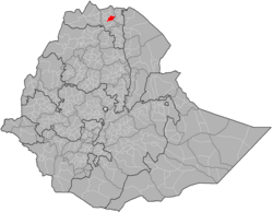
| Region | Tigray |
| Zone | Mehakelegnaw (Central) |
| Area | |
| • Total | 2,360.17 km2 (911.27 sq mi) |
| Population (2007) | |
| • Total | 146,104 |

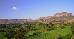
Werie Lehe (Tigrinya: ወርዒ ለኸ) is one of the Districts of Ethiopia, or woredas, in the Tigray Region of Ethiopia. Part of the Mehakelegnaw Zone, Werie Lehe is bordered on the south by the Wari River which separates it from Kola Tembien, on the southwest by Naeder Adet, on the west by La'ilay Maychew, on the north by Adwa, on the northeast by Enticho, and on the east by the Misraqawi (Eastern) Zone. In 2020 this woreda was divided into three new woredas: Indafelasi (administrative centre: ), Weri'i (Edaga Arbi) and Imba Seneyti().
Local landmarks in this woreda include several monolithic churches, which include Wkro Mariyam, Wkro Giyorgis and Abba Ghenzay near Nebelet.[1]
History[]
The area around Nebelet is historically called Imba Seneyti. It appears on indigenous maps of the northern Horn of Africa in the 15th Century.[2][3]
Demographics[]
Based on the 2007 national census conducted by the Central Statistical Agency of Ethiopia (CSA), this woreda has a total population of 146,104, an increase of 32.06% over the 1994 census, of whom 71,659 are men and 74,445 women; 16,525 or 11.31% are urban inhabitants. With an area of 2,360.17 square kilometers, Werie Lehe has a population density of 61.90, which is greater than the Zone average of 56.29 persons per square kilometer. A total of 32,591 households were counted in this woreda, resulting in an average of 4.48 persons to a household, and 31,090 housing units. The majority of the inhabitants said they practiced Ethiopian Orthodox Christianity, with 98.59% reporting that as their religion, while 1.4% of the population were Muslim.[4]
The 1994 national census reported a total population for this woreda of 110,636, of whom 54,207 were men and 56,429 were women; 4,538 or 4.1% of its population were urban dwellers. The largest ethnic group reported in Werie Lehe was the Tigrayan (99.9%). Tigrinya was spoken as a first language by 99.93%. 98.49% of the population practiced Ethiopian Orthodox Christianity, and 1.44% were Muslim. Concerning education, 15.14% of the population were considered literate, which is more than the Zone average of 14.21%; 14.97% of children aged 7–12 were in primary school; 0.1% of the children aged 13–14 were in junior secondary school, and 0.12% of the inhabitants aged 15–18 were in senior secondary school. Concerning sanitary conditions, about 83% of the urban houses and 13% of all houses had access to safe drinking water at the time of the census; about 2% of the urban and 2% of the total had toilet facilities.[5]
Agriculture[]
A sample enumeration performed by the CSA in 2001 interviewed 27,199 farmers in this woreda, who held an average of 1.09 hectares of land. Of the 29,738 hectares of private land surveyed, 82.1% was in cultivation, 0.85% pasture, 13.84% fallow, 0.22% woodland, and 2.97% was devoted to other uses. For the land under cultivation in this woreda, 73.22% was planted in cereals, 7.2% in pulses, 1.16% in oilseeds, and 0.09% in vegetables. The area planted in fruit trees was 38 hectares; the area planted in gesho is missing. 79.85% of the farmers both raised crops and livestock, while 18.6% only grew crops and 1.55% only raised livestock. Land tenure in this woreda is distributed amongst 83.24% owning their land, 12.24% renting, and 4.52% in other forms of tenure.[6]
The Ethiopian News Agency announced 31 July 2009 that for the year farmers in the woreda harvested 113,044 quintals of various vegetables and fruits grown on 1,685 hectares of land, a 30% increase over the previous year.[7]
History[]
2020 woreda reorganisation[]
Between 2018 and 2020, as part of a reform aimed to deepen and strengthen decentralisation, woredas were reorganised, and a new woreda organisation came into existence in Tigray.[8][self-published source] As smaller towns had been growing, they have started providing a range of services (markets, even banks), so that people were travelling to the closest such towns for these services, but continued to have to travel to the formal woreda centre, often in a different direction, for most government administrative services. A huge consultation, involving numerous village meetings, was organised in 2018 and 2019, with heated debates, particularly in the more remote areas. Based on these consultations, woreda Weri'i Lehi became inoperative and as of early 2020, its territory belongs to the following new woredas:
- Indafelasi
- Weri'i woreda
- Imba Seneyti (centre: Nebelet)
Massacres in the Tigray War (2020-2021)[]
The Eritrean Defence Forces (EDF) killed around 1000 civilians during the Tigray War. In Indafelasi alone, the following massacres occurred:[8][self-published source][9]
- First Addi Geba massacre on 15 February 2021: 14 civilians killed.
- Second Addi Geba massacre on 27 February 2021: 39 civilians killed.
- May Kinetal massacre on 24-27 February and 5 March 2021: 263 civilians killed.
- Indafelasi killing spree on 6 April 2021: 125 civilians killed.
Surrounding woredas[]
Places adjacent to Werie Lehe | ||||||||||||||||
|---|---|---|---|---|---|---|---|---|---|---|---|---|---|---|---|---|
| ||||||||||||||||
Notes[]
- ^ Descriptions of these three can be found in Ruth Plant with David Buxton, "Rock-hewn Churches of the Tigre Province", Ethiopia Observer, 13 (1970), pp. 264-266.
- ^ Nyssen, J., Tesfaalem Ghebreyohannes, Hailemariam Meaza, Dondeyne, S., 2020. Exploration of a medieval African map (Aksum, Ethiopia) – How do historical maps fit with topography? In: De Ryck, M., Nyssen, J., Van Acker, K., Van Roy, W., Liber Amicorum: Philippe De Maeyer In Kaart. Wachtebeke (Belgium): University Press: 165-178.
- ^ Smidt W (2003) Cartography, in: Uhlig S (ed.): Encyclopaedia Aethiopica, Wiesbaden: Harrassowitz, vol. 1: 688-691
- ^ Census 2007 Tables: Tigray Region, Tables 2.1, 2.4, 2.5 and 3.4.
- ^ 1994 Population and Housing Census of Ethiopia: Results for Southern Nations, Nationalities and Peoples' Region, Vol. 1, part 1, Tables 2.1, 2.12, 2.19, 3.5, 3.7, 6.3, 6.11, 6.13 (accessed 30 December 2008)
- ^ "Central Statistical Authority of Ethiopia. Agricultural Sample Survey (AgSE2001). Report on Area and Production - Tigray Region. Version 1.1 - December 2007" (accessed 26 January 2009)
- ^ "Farmers in Wore'leh secure over 76.4 mln Birr", ENA (accessed 1 November 2009)
- ^ a b Annys, S., Vanden Bempt, T., Negash, E., De Sloover, L., Nyssen, J., 2021. Tigray: Atlas of the humanitarian situation, map 3
- ^ Associated Press, 30 June 2021: Trapped in Ethiopia’s Tigray, people ‘falling like leaves’
- Districts of Tigray Region