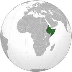
Horn of Africa
| Horn of Africa | |
|---|---|
 | |
| Countries and territories | show
4 sovereign states show
1 sovereign state with limited recognition |
| Demonym(s) | Regional demonyms: National demonyms:
|
| Major regional organizations |
|
| Population | 140,683,144 (2020 est.) |
| Area | 1,882,757 km2 |
| Main native languages | |
| Main foreign working languages |
|
| Religion | Sunni Islam, Christianity, traditional faiths, Judaism (formerly in Ethiopia, most have migrated to Israel) |
| Time zones | UTC+03:00 |
| Currency |
|
| Capitals | Djibouti (Djibouti) Asmara (Eritrea) Addis Ababa (Ethiopia) Mogadishu (Somalia) Hargeisa (Somaliland) |
| Total GDP (PPP) | $247.751 billion (2016) ($2,020 per capita) |
| Total GDP (nominal) | $102.057 billion (2016) ($832 per capita) |
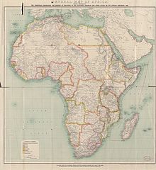
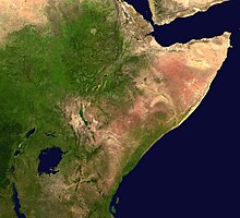
The Horn of Africa (HoA)[nb 1] is the easternmost peninsula of the African continent,[1][2][3][4] excluding African islands. It lies along the southern boundary of the Red Sea and extends hundreds of kilometers into the Gulf of Aden, Somali Sea and Guardafui Channel.
The Horn of Africa consists of the internationally recognized countries of Djibouti, Eritrea, Ethiopia and Somalia, as well as the unrecognized country of Somaliland.[5][3][2][1][6] It covers approximately two million square kilometers (770,000 square miles) and is inhabited by roughly 115 million people (Ethiopia: 110 million, Somalia: 10.9 million, Eritrea: 6.4 million, Somaliland: 5.7 million and Djibouti: 921.8 thousand). In ancient and medieval times, it was known in the Western world as the "land of the Barbaria and Ethiopians".[7][8][9] Regional studies on the Horn of Africa are carried out in fields such as Ethiopian studies and Somali studies.
Names[]
This peninsula has been known by various names. Ancient Greeks and Romans referred to it as Regio Aromatica or Regio Cinnamonifora due to the aromatic plants or as Regio Incognita owing to its uncharted territory. In ancient and medieval times, the Horn of Africa was referred to as the Bilad al Barbar ("Land of the Berbers").[7][8][9] It is also known as the Somali peninsula or, in the Somali language, Geeska Afrika, Jasiiradda Soomaali or Gacandhulka Soomaali.[10] In other local languages, it is called "the Horn of Africa" or "the African Horn": in Amharic የአፍሪካ ቀንድ yäafrika qänd, in Arabic القرن الأفريقي al-qarn al-'afrīqī, in Oromo Gaaffaa Afriikaa, and in Tigrinya ቀርኒ ኣፍሪቃ q’ärnī afīrīqa. The name Horn of Africa is sometimes shortened to HoA. Quite commonly it is referred to simply as "the Horn", while inhabitants are sometimes colloquially termed Horn Africans.[11][12] Sometimes the term Greater Horn of Africa is used, either to be inclusive of neighbouring northeast African countries or to distinguish the broader geopolitical definition of the Horn of Africa from narrower peninsular definitions.[13][12]
History[]
Prehistory[]
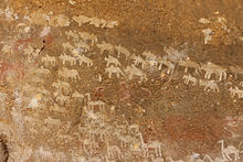
According to the Southern Dispersal scenario, the Southern route of the Out of Africa migration occurred in the Horn of Africa through the Bab el Mandeb. Today at the Bab-el-Mandeb straits, the Red Sea is about 12 miles (20 kilometres) wide, but 50,000 years ago it was much narrower and sea levels were 70 meters lower. Though the straits were never completely closed, there may have been islands in between which could be reached using simple rafts. Shell middens 125,000 years old have been found in Eritrea,[14] indicating the diet of early humans included seafood obtained by beachcombing.
The findings of the Earliest Stone Tipped Projectiles from the Ethiopian Rift dated to more than 279,000 years ago in combination with the existing archaeological, fossil and genetic evidence, isolate this region as a source of modern cultures and biology, and it is considered the place of origin for humankind.[15][16][17]
Ethiopian and Eritrean agriculture established the earliest known use of the seed grass teff (Poa abyssinica) between 4000 and 1000 BCE.[18] Teff is used to make the flatbread injera/taita. Coffee also originated in Ethiopia and has since spread to become a worldwide beverage.[19]
Ancient history[]
The area comprising Somaliland, Djibouti, the Red Sea coast of Eritrea and Sudan is considered the most likely location of the land known to the ancient Egyptians as Punt (or "Ta Netjeru," meaning god's land), whose first mention dates to the 25th century BC.[20]

Macrobia was an ancient kingdom situated in the Horn of Africa (Present day Somalia) it is mentioned in the 5th century BC. According to Herodotus' account, the Persian Emperor Cambyses II upon his conquest of Egypt (525 BC) sent ambassadors to Macrobia, bringing luxury gifts for the Macrobian king to entice his submission. The Macrobian ruler, who was elected based at least in part on stature, replied instead with a challenge for his Persian counterpart in the form of an unstrung bow: if the Persians could manage to string it, they would have the right to invade his country; but until then, they should thank the gods that the Macrobians never decided to invade their empire .[21][22][23]
The Macrobians were a regional power reputed for their advanced architecture and gold wealth, which was so plentiful that they shackled their prisoners in golden chains.[24]
After the collapse of Macrobia, several wealthy ancient city-states, such as Opone, Essina, Sarapion, Nikon, Malao, Damo and Mosylon near Cape Guardafui would emerge from the 1st millennium BC–500 AD to compete with the Sabaeans, Parthians and Axumites for the wealthy Indo-Greco-Roman trade and flourished along the Somali coast. They developed a lucrative trading network under a region collectively known in the Peripilus of the Erythraean Sea as Barbaria[25]

Dʿmt was a kingdom located in Eritrea and northern Ethiopia, which existed during the 8th and 7th centuries BC. With its capital probably at Yeha, the kingdom developed irrigation schemes, used plows, grew millet, and made iron tools and weapons. After the fall of Dʿmt in the 5th century BC, the plateau came to be dominated by smaller successor kingdoms, until the rise of one of these kingdoms during the 1st century, the Aksumite Kingdom, which was able to reunite the area.[26]
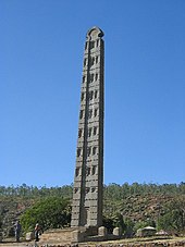
The Kingdom of Aksum (also known as the Aksumite Empire) was an ancient state located in the Eritrea and Ethiopian highlands, which thrived between the 1st and 7th centuries AD. A major player in the commerce between the Roman Empire and Ancient India, Aksum's rulers facilitated trade by minting their own currency. The state also established its hegemony over the declining Kingdom of Kush and regularly entered the politics of the kingdoms on the Arabian peninsula, eventually extending its rule over the region with the conquest of the Himyarite Kingdom. Under Ezana (fl. 320–360), the kingdom of Aksum became the first major empire to adopt Christianity, and was named by Mani as one of the four great powers of his time, along with Persia, Rome and China.
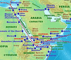
Somalia was an important link in the Horn, connecting the region's commerce with the rest of the ancient world. Somali sailors and merchants were the main suppliers of frankincense, myrrh and spices, all of which were valuable luxuries to the Ancient Egyptians, Phoenicians, Mycenaeans, Babylonians and Romans.[27][28] The Romans consequently began to refer to the region as Regio Aromatica. In the classical era, several flourishing Somali city-states such as Opone, Mosylon and Malao also competed with the Sabaeans, Parthians and Axumites for the rich Indo-Greco-Roman trade.[29]
The birth of Islam opposite the Horn's Red Sea coast meant that local merchants and sailors living on the Arabian Peninsula gradually came under the influence of the new religion through their converted Arab Muslim trading partners. With the migration of Muslim families from the Islamic world to the Horn in the early centuries of Islam, and the peaceful conversion of the local population by Muslim scholars in the following centuries, the ancient city-states eventually transformed into Islamic Mogadishu, Berbera, Zeila, Barawa and Merka, which were part of the Barbara civilization.[30][31] The city of Mogadishu came to be known as the "City of Islam"[32] and controlled the East African gold trade for several centuries.[33]
Middle Ages and Early Modern era[]
During the Middle Ages, several powerful empires dominated the regional trade in the Horn, including the Adal Sultanate, the Ajuran Sultanate, the Zagwe dynasty, and the Sultanate of the Geledi.
The Sultanate of Showa, established in 896, was one of the oldest local Islamic states. It was centered in the former Shewa province in central Ethiopia. The polity was succeeded by the Sultanate of Ifat around 1285. Ifat was governed from its capital at Zeila in Somaliland and was the easternmost district of the former Shewa Sultanate.[34]
The Adal Sultanate was a medieval multi-ethnic Muslim state centered in the Horn region. At its height, it controlled large parts of Somalia, Ethiopia, Djibouti and Eritrea. Many of the historic cities in the region, such as Amud, Maduna, Abasa, Berbera, Zeila and Harar, flourished during the kingdom's golden age. This period that left behind numerous courtyard houses, mosques, shrines and walled enclosures. Under the leadership of rulers such as Sabr ad-Din II, Mansur ad-Din, Jamal ad-Din II, Shams ad-Din, General Mahfuz and Ahmad ibn Ibrahim al-Ghazi, Adalite armies continued the struggle against the Solomonic dynasty, a campaign historically known as the Conquest of Abyssinia or Futuh al Habash.
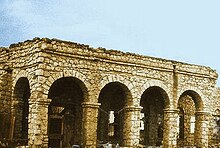
Through a strong centralized administration and an aggressive military stance towards invaders, the Ajuran Sultanate successfully resisted an Oromo invasion from the west and a Portuguese incursion from the east during the Gaal Madow and the Ajuran-Portuguese wars. Trading routes dating from the ancient and early medieval periods of Somali maritime enterprise were also strengthened or re-established, and the state left behind an extensive architectural legacy. Many of the hundreds of ruined castles and fortresses that dot the landscape of Somalia today are attributed to Ajuran engineers,[35] including a lot of the pillar tomb fields, necropolises and ruined cities built during that era. The royal family, the House of Gareen, also expanded its territories and established its hegemonic rule through a skillful combination of warfare, trade linkages and alliances.[36]
The Zagwe dynasty ruled many parts of modern Ethiopia and Eritrea from approximately 1137 to 1270. The name of the dynasty comes from the Cushitic-speaking Agaw people of northern Ethiopia. From 1270 onwards for many centuries, the Solomonic dynasty ruled the Ethiopian Empire.
In the early 15th century, Ethiopia sought to make diplomatic contact with European kingdoms for the first time since Aksumite times. A letter from King Henry IV of England to the Emperor of Abyssinia survives.[37] In 1428, the Emperor Yeshaq sent two emissaries to Alfonso V of Aragon, who sent return emissaries who failed to complete the return trip.[38]
The first continuous relations with a European country began in 1508 with Portugal under Emperor Lebna Dengel, who had just inherited the throne from his father.[39] This proved to be an important development, for when Abyssinia was subjected to the attacks of the Adal Sultanate General and Imam Ahmad ibn Ibrahim al-Ghazi (called "Gurey" or "Grañ", both meaning "the Left-handed"), Portugal assisted the Ethiopian emperor by sending weapons and four hundred men, who helped his son Gelawdewos defeat Ahmad and re-establish his rule.[40] This Abyssinian–Adal War was also one of the first proxy wars in the region as the Ottoman Empire, and Portugal took sides in the conflict.

When Emperor Susenyos converted to Roman Catholicism in 1624, years of revolt and civil unrest followed resulting in thousands of deaths.[41] The Jesuit missionaries had offended the Orthodox faith of the local Ethiopians. On 25 June 1632, Susenyos's son, Emperor Fasilides, declared the state religion to again be Ethiopian Orthodox Christianity, and expelled the Jesuit missionaries and other Europeans.[42][43]
During the end of 18th and the beginning of 19th century the Yejju dynasty (more specifically, the Warasek) ruled north Ethiopia changing the official language of Amhara people to Afaan Oromo, including inside the court of Gondar which was capital of the empire. Founded by Ali I of Yejju several successive descendants of him and Abba Seru Gwangul ruled with their army coming from mainly their clan the Yejju Oromo tribe as well as Wollo and Raya Oromo.[44]
The Sultanate of the Geledi was a Somali kingdom administered by the Gobroon dynasty, which ruled parts of the Horn of Africa during the 18th and 19th centuries. It was established by the Ajuran soldier Ibrahim Adeer, who had defeated various vassals of the Ajuran Empire and established the House of Gobroon. The dynasty reached its apex under the successive reigns of Sultan Yusuf Mahamud Ibrahim, who successfully consolidated Gobroon power during the Bardera wars, and Sultan Ahmed Yusuf, who forced regional powers such as the Omani Empire to submit tribute.
The Isaaq Sultanate was a Somali kingdom that ruled parts of the Horn of Africa during the 18th and 19th centuries. It spanned the territories of the Isaaq clan, descendants of the Banu Hashim clan,[45] in modern-day Somaliland and Ethiopia. The sultanate was governed by the Rer Guled branch established by the first sultan, Sultan Guled Abdi, of the Eidagale clan. The sultanate is the pre-colonial predecessor to the modern Republic of Somaliland.[46][47][48]
According to oral tradition, prior to the Guled dynasty the Isaaq clan-family were ruled by a dynasty of the Tolje'lo branch starting from, descendants of Ahmed nicknamed Tol Je'lo, the eldest son of Sheikh Ishaaq's Harari wife. There were eight Tolje'lo rulers in total, starting with Boqor Harun (Somali: Boqor Haaruun) who ruled the Isaaq Sultanate for centuries starting from the 13th century.[49][50] The last Tolje'lo ruler Garad Dhuh Barar (Somali: Dhuux Baraar) was overthrown by a coalition of Isaaq clans. The once strong Tolje'lo clan were scattered and took refuge amongst the Habr Awal with whom they still mostly live.[51][52]
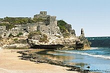
The Majeerteen Sultanate (Migiurtinia) was another prominent Somali sultanate based in the Horn region. Ruled by King Osman Mahamuud during its golden age, it controlled much of northeastern and central Somalia in the 19th and early 20th centuries. The polity had all of the organs of an integrated modern state and maintained a robust trading network. It also entered into treaties with foreign powers and exerted strong centralized authority on the domestic front.[53][54] Much of the Sultanate's former domain is today coextensive with the autonomous Puntland region in northern Somalia.[55]
The Sultanate of Hobyo was a 19th-century Somali kingdom founded by Sultan Yusuf Ali Kenadid. Initially, Kenadid's goal was to seize control of the neighboring Majeerteen Sultanate, which was then ruled by his cousin Boqor Osman Mahamuud. However, he was unsuccessful in this endeavor, and was eventually forced into exile in Yemen. A decade later, in the 1870s, Kenadid returned from the Arabian Peninsula with a band of Hadhrami musketeers and a group of devoted lieutenants. With their assistance, he managed to establish the kingdom of Hobyo, which would rule much of northern and central Somalia during the early modern period.[56]
Modern history[]

In the period following the opening of the Suez canal in 1869, when European powers scrambled for territory in Africa and tried to establish coaling stations for their ships, Italy invaded and occupied Eritrea. On 1 January 1890, Eritrea officially became a colony of Italy. In 1896 further Italian incursion into the horn was decisively halted by Ethiopian forces. By 1936 however, Eritrea became a province of Italian East Africa (Africa Orientale Italiana), along with Ethiopia and Italian Somaliland. By 1941, Eritrea had about 760,000 inhabitants, including 70,000 Italians.[57] The Commonwealth armed forces, along with the Ethiopian patriotic resistance, expelled those of Italy in 1941,[58] and took over the area's administration. The British continued to administer the territory under a UN Mandate until 1951, when Eritrea was federated with Ethiopia, as per UN resolution 390(A) and under the prompting of the United States adopted in December 1950.
The strategic importance of Eritrea, due to its Red Sea coastline and mineral resources, was the main cause for the federation with Ethiopia, which in turn led to Eritrea's annexation as Ethiopia's 14th province in 1952. This was the culmination of a gradual process of takeover by the Ethiopian authorities, a process which included a 1959 edict establishing the compulsory teaching of Amharic, the main language of Ethiopia, in all Eritrean schools. The lack of regard for the Eritrean population led to the formation of an independence movement in the early 1960s (1961), which erupted into a 30-year war against successive Ethiopian governments that ended in 1991. Following a UN-supervised referendum in Eritrea (dubbed UNOVER) in which the Eritrean people overwhelmingly voted for independence, Eritrea declared its independence and gained international recognition in 1993.[59] In 1998, a border dispute with Ethiopia led to the Eritrean-Ethiopian War.[60]
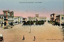
From 1862 until 1894, the land to the north of the Gulf of Tadjoura situated in modern-day Djibouti was called Obock and was ruled by Somali and Afar Sultans, local authorities with whom France signed various treaties between 1883 and 1887 to first gain a foothold in the region.[61][62][63] In 1894, Léonce Lagarde established a permanent French administration in the city of Djibouti and named the region Côte française des Somalis (French Somaliland), a name which continued until 1967.
In 1958, on the eve of neighboring Somalia's independence in 1960, a referendum was held in the territory to decide whether or not to join the Somali Republic or to remain with France. The referendum turned out in favour of a continued association with France, partly due to a combined yes vote by the sizable Afar ethnic group and resident Europeans.[64] There was also reports of widespread vote rigging, with the French expelling thousands of Somalis before the referendum reached the polls.[65] The majority of those who voted no were Somalis who were strongly in favour of joining a united Somalia, as had been proposed by Mahmoud Harbi, Vice President of the Government Council. Harbi was killed in a plane crash two years later.[64] Djibouti finally gained its independence from France in 1977, and Hassan Gouled Aptidon, a Somali politician who had campaigned for a yes vote in the referendum of 1958, eventually wound up as the nation's first president (1977–1999).[64] In early 2011, the Djiboutian citizenry took part in a series of protests against the long-serving government, which were associated with the larger Arab Spring demonstrations. The unrest eventually subsided by April of the year, and Djibouti's ruling People's Rally for Progress party was re-elected to office.

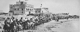
The Dervish movement existed for 25 years, from 1895 until 1920; it had a Darawiish Sultan, named Diiriye Guure, an emir, named Sayid Mohamed[66] and a government called the Haroun.[67] The haroun (i.e. government), the Darawiish king Diiriye Guure and its emir carved out a powerful state which was subdivided into 13 administrative divisions of which the four largest, Shiikhyaale, Dooxato, Golaweyne, Miinanle were near exclusively Dhulbahante. The other administrative divisions, Taargooye, Dharbash, Indhabadan, Burcadde-Godwein, Garbo (Darawiish), Ragxun, Gaarhaye, Bah-udgoon and Shacni-cali were also overwhelmingly Dhulbahante.[68] The Turks also named Hassan Emir of the Somali nation,[69] and the Germans promised to officially recognize any territories the Dervishes were to acquire.[70] After a quarter of a century of holding the British at bay, the Dervishes were finally defeated in 1920 as a direct consequence of Britain's new policy of aerial bombardment.[71] As a result of this bombardment, former Dervish territories were turned into a protectorate of Britain. Italy faced similar opposition from Somali Sultans and armies, and did not acquire full control of modern Somalia until the Fascist era in late 1927. This occupation lasted until 1941, and was replaced by a British military administration. Somaliland would remain a protectorate, while Somalia became a trusteeship. The Union of the two countries in 1960 formed the Somali Republic. A civilian government was formed, and on 20 July 1961, through a popular referendum, a new constitution that had first been drafted the year before was ratified.[72]
Due to its longstanding ties with the Arab world, the Somali Republic was accepted in 1974 as a member of the Arab League.[73] During the same year, the nation's former socialist administration also chaired the Organization of African Unity, the predecessor of the African Union.[74] In 1991, the Somali Civil War broke out, which saw the dissolving of the union and Somaliland regaining its independence, along with the collapse of the central government and the emergence of numerous autonomous polities, including the Puntland administration in the north.[75] in the northwest. Somalia's inhabitants subsequently reverted to local forms of conflict resolution, either secular, Islamic or customary law, with a provision for appeal of all sentences. A Transitional Federal Government was subsequently created in 2004.[76] The Federal Government of Somalia was established on 20 August 2012, concurrent with the end of the TFG's interim mandate.[77] It represents the first permanent central government in the country since the start of the civil war.[77] The Federal Parliament of Somalia serves as the government's legislative branch.[78]
Modern Ethiopia and its current borders are a result of significant territorial reduction in the north and expansion in the east and south toward its present borders, owing to several migrations, commercial integration, treaties as well as conquests, particularly by Emperor Menelik II and Ras Gobena.[79] From the central province of Shoa, Menelik set off to subjugate and incorporate ‘the lands and people of the South, East and West into an empire.’[79][80] He did this with the help of Ras Gobena's Shewan Oromo militia, began expanding his kingdom to the south and east, expanding into areas that had not been held since the invasion of Ahmad ibn Ibrihim al-Ghazi, and other areas that had never been under his rule, resulting in the borders of Ethiopia of today.[81] Menelik had signed the Treaty of Wichale with Italy in May 1889, in which Italy would recognize Ethiopia's sovereignty so long as Italy could control a small area of northern Tigray (part of modern Eritrea).[82] In return Italy, was to provide Menelik with arms and support him as emperor.[83] The Italians used the time between the signing of the treaty and its ratification by the Italian government to further expand their territorial claims. Italy began a state funded program of resettlement for landless Italians in Eritrea, which increased tensions between the Eritrean peasants and the Italians.[83] This conflict erupted in the Battle of Adwa on 1 March 1896, in which Italy's colonial forces were defeated by the Ethiopians.[84]
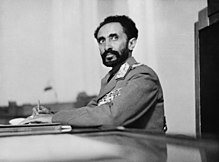
The early 20th century in Ethiopia was marked by the reign of Emperor Haile Selassie I, who came to power after Iyasu V was deposed. In 1935, Haile Selassie's troops fought and lost the Second Italo-Abyssinian War, after which point Italy annexed Ethiopia to Italian East Africa.[85] Haile Selassie subsequently appealed to the League of Nations, delivering an address that made him a worldwide figure and 1935's Time magazine Man of the Year.[86] Following the entry of Italy into World War II, British Empire forces, together with patriot Ethiopian fighters, liberated Ethiopia in the course of the East African Campaign in 1941.[87]

Haile Selassie's reign came to an end in 1974, when a Soviet-backed Marxist-Leninist military junta, the Derg led by Mengistu Haile Mariam, deposed him, and established a one-party communist state, which was called the People's Democratic Republic of Ethiopia. In July 1977, the Ogaden War broke out after the government of President of Somalia Siad Barre sought to incorporate the predominantly Somali-inhabited Ogaden region into a Pan-Somali Greater Somalia. By September 1977, the Somali army controlled 90% of the Ogaden, but was later forced to withdraw after Ethiopia's Derg received assistance from the USSR, Cuba, South Yemen, East Germany[88] and North Korea, including around 15,000 Cuban combat troops.
In 1989, the Tigrayan Peoples' Liberation Front (TPLF) merged with other ethnically based opposition movements to form the Ethiopian Peoples' Revolutionary Democratic Front (EPRDF), and eventually managed to overthrow Mengistu's dictatorial regime in 1991. A transitional government, composed of an 87-member Council of Representatives and guided by a national charter that functioned as a transitional constitution, was then set up. The first free and democratic election took place later in 1995, when Ethiopia's longest-serving Prime Minister Meles Zenawi was elected to office. As with other nations in the Horn region, Ethiopia maintained its historically close relations with countries in the Middle East during this period of change.[89] Zenawi died in 2012, but his Ethiopian People's Revolutionary Democratic Front (EPRDF) party remains the ruling political coalition in Ethiopia.
Geography[]
Geology and climate[]
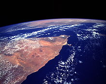
The Horn of Africa is almost equidistant from the equator and the Tropic of Cancer. It consists chiefly of mountains uplifted through the formation of the Great Rift Valley, a fissure in the Earth's crust extending from Turkey to Mozambique and marking the separation of the African and Arabian tectonic plates. Mostly mountainous, the region arose through faults resulting from the Rift Valley.
Geologically, the Horn and Yemen once formed a single landmass around 18 million years ago, before the Gulf of Aden rifted and separated the Horn region from the Arabian Peninsula.[90][91] The Somali Plate is bounded on the west by the East African Rift, which stretches south from the triple junction in the Afar Depression, and an undersea continuation of the rift extending southward offshore. The northern boundary is the Aden Ridge along the coast of Saudi Arabia. The eastern boundary is the Central Indian Ridge, the northern portion of which is also known as the Carlsberg Ridge. The southern boundary is the Southwest Indian Ridge.
Extensive glaciers once covered the Simien and Bale Mountains but melted at the beginning of the Holocene. The mountains descend in a huge escarpment to the Red Sea and more steadily to the Indian Ocean. Socotra is a small island in the Indian Ocean off the coast of Somalia. Its size is 3,600 km2 (1,390 sq mi) and it is a territory of Yemen.
The lowlands of the Horn are generally arid in spite of their proximity to the equator. This is because the winds of the tropical monsoons that give seasonal rains to the Sahel and the Sudan blow from the west. Consequently, they lose their moisture before reaching Djibouti and Somaliland, with the result that most of the Horn receives little rainfall during the monsoon season.
In the mountains of Ethiopia, many areas receive over 2,000 mm (80 in) per year, and even Asmara receives an average of 570 mm (23 in). This rainfall is the sole source of water for many areas outside Ethiopia, including Egypt. In the winter, the northeasterly trade winds do not provide any moisture except in mountainous areas of northern Somalia, where rainfall in late autumn can produce annual totals as high as 500 mm (20 in). On the eastern coast, a strong upwelling and the fact that the winds blow parallel to the coast means annual rainfall can be as low as 50 mm (2 in).
The climate in Ethiopia varies considerably between regions. It is generally hotter in the lowlands and temperate on the plateau. At Addis Ababa, which ranges from 2,200 to 2,600 m (7,218 to 8,530 ft), maximum temperature is 26 °C (78.8 °F) and minimum 4 °C (39.2 °F). The weather is usually sunny and dry, but the short (belg) rains occur from February to April and the big (meher) rains from mid-June to mid-September. The Danakil Desert stretches across 100,000 km2 of arid terrain in northeast Ethiopia, southern Eritrea, and northwestern Djibouti. The area is known for its volcanoes and extreme heat, with daily temperatures over 45 °C and often surpassing 50 °C. It has a number of lakes formed by lava flows that dammed up several valleys. Among are Lake Asale (116 m below sea level) and Lake Giuletti/Afrera (80 m below sea level), both of which possess cryptodepressions in the Danakil Depression. The Afrera contains many active volcanoes, including the Maraho, Dabbahu, Afdera and Erta Ale.[92][93]
In Somalia and Somaliland, there is not much seasonal variation in climate. Hot conditions prevail year-round along with periodic monsoon winds and irregular rainfall. Mean daily maximum temperatures range from 28 to 43 °C (82 to 109 °F), except at higher elevations along the eastern seaboard, where the effects of a cold offshore current can be felt. Somalia has only two permanent rivers, the Jubba and the Shabele, both of which begin in the Ethiopian Highlands.[94]
Ecology[]

About 220 mammals are found in the Horn of Africa. Among threatened species of the region, there are several antelopes such as the beira, the dibatag, the silver dikdik and the Speke's gazelle. Other remarkable species include the Somali wild ass, the desert warthog, the hamadryas baboon, the Somali pygmy gerbil, the ammodile, and the Speke's pectinator. The Grevy's zebra is the unique wild equid of the region. There are predators such as spotted hyena, striped hyena and African leopard. The endangered painted hunting dog had populations in the Horn of Africa, but pressures from human exploitation of habitat along with warfare have reduced or extirpated this canid in this region.[95]
Some important bird species of the Horn are the black boubou, the golden-winged grosbeak, the Warsangli linnet, and the Djibouti spurfowl.
The Horn of Africa holds more endemic reptiles than any other region in Africa, with over 285 species total and about 90 species which are found exclusively in the region. Among endemic reptile genera, there are Haackgreerius, Haemodracon, Ditypophis, Pachycalamus and Aeluroglena. Half of these genera are uniquely found on Socotra. Unlike reptiles, amphibians are poorly represented in the region.
There are about 100 species of freshwater fish in the Horn of Africa, about 10 of which are endemic. Among the endemic, the cave-dwelling Somali blind barb and the Somali cavefish can be found.
It is estimated that about 5,000 species of vascular plants are found in the Horn, about half of which are endemic. Endemism is most developed in Socotra and northern Somalia. The region has two endemic plant families: the Barbeyaceae and the Dirachmaceae. Among the other remarkable species, there are the cucumber tree found only on Socotra (Dendrosicyos socotrana), the Bankoualé palm, the yeheb nut, and the Somali cyclamen.
Due to the Horn of Africa's semi-arid and arid climate, droughts are not uncommon. They are complicated by climate change and changes in agricultural practices. For centuries, the region's pastoral groups have observed careful rangeland management practices to mitigate the effects of drought, such as avoiding overgrazing or setting aside land only for young or ill animals. However, population growth has put pressure on limited land and led to these practices no longer being maintained. Droughts in 1983–85, 1991–92, 1998–99 and 2011 have disrupted periods of gradual growth in herd numbers, leading to a decrease of between 37% and 62% of the cattle population. Initiatives by ECHO and USAID have succeeded in reclaiming hundreds of hectares of pastureland through rangeland management, leading to the establishment of the Dikale Rangeland in 2004.[96]
Demographics, ethnicity and languages[]

Besides sharing similar geographic endowments, the countries of the Horn of Africa are, for the most part, linguistically and ethnically linked together,[1] evincing a complex pattern of interrelationships among the various groups.[97] The two main macro groups in the Horn are the Cushitic-speaking Cushitic peoples traditionally centered in the lowlands and the Ethiosemitic-speaking Ethiopian Highlanders and Eritrean Highlanders centered in the highlands.

According to Ethnologue, there are 10 individual languages spoken in Djibouti (two native), 14 in Eritrea, 90 in Ethiopia, 15 in Somalia (Somali being the only native) and 3 in Somaliland.[98] Most people in the Horn speak Afroasiatic languages of the Cushitic or Semitic branches. The former includes Oromo, spoken by the Oromo people in Ethiopia, and Somali, spoken by the Somali people in Somalia, Somaliland, Djibouti, Ethiopia and Kenya; the latter includes Amharic, spoken by the Amhara people of Ethiopia, and Tigrinya spoken by the Tigrayan people of Eritrea and Ethiopia. Other Afroasiatic languages with a significant number of speakers include the Cushitic Afar, Saho, Hadiyya, Sidamo and Agaw languages, as well as the Semitic Tigre, Arabic, Gurage, Harari, Silt'e and Argobba tongues.[99]
Additionally, Omotic languages are spoken by Omotic communities inhabiting Ethiopia's southern regions. Among these idioms are Aari, Dizi, Gamo, Kafa, Hamer and Wolaytta.[100]
Languages belonging to the Nilo-Saharan language family are also spoken in some areas by Nilotic ethnic minorities mostly in Ethiopia and Eritrea. These tongues include the Nilo-Saharan Me'en and Mursi languages used in southwestern Ethiopia, and Kunama and Nara idioms spoken in parts of southern Eritrea.
Languages belonging to the Niger-Congo language family are also spoken in some areas by Bantu ethnic minorities in Somalia. In the riverine and littoral areas of southern Somalia, Bajuni, Barawani, and Bantu groups also speak variants of the Niger-Congo Swahili and Mushunguli languages.[101][102]
The Horn has produced numerous indigenous writing systems. Among these is Ge'ez script (ግዕዝ Gəʿəz) (also known as Ethiopic), which has been written in for at least 2000 years.[103] It is an abugida script that was originally developed to write the Ge'ez language. In speech communities that use it, such as the Amharic and Tigrinya, the script is called fidäl (ፊደል), which means "script" or "alphabet".

For centuries, Somali sheikhs and Sultans used the Wadaad script (a version of the Arab alphabets) to write. In the early 20th century, in response to a national campaign to settle on a writing script for the Somali language (which had long since lost its ancient script[104]), Osman Yusuf Kenadid, a Somali poet and remote cousin of the Sultan Yusuf Ali Kenadid of the Sultanate of Hobyo, devised a phonetically sophisticated alphabet called Osmanya (also known as far soomaali; Osmanya: