Wetlands of Bogotá
| Designations | |
|---|---|
| Official name | Complejo de Humedales Urbanos del Distrito Capital de Bogotá |
| Designated | 6 August 2018 |
| Reference no. | 2404[1] |
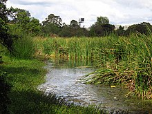
Wetlands of Bogotá, Colombia are important areas of the capital city, and their development has become increasingly important for the area north of the Andes. A reserve for fauna and flora, the wetlands provide for the preservation and reproduction of a wide variety of mammals, reptiles and birds. These include more than 95 species of migratory birds, as well as many endemic plant species. The wetlands are part of the Bogotá River basin. The wetland complex has been designated as a protected Ramsar site since 2018.[1]
Three types of wetland ecosystems have been identified in the district, differentiated by origin and position: plain wetlands are located in urban areas, while hillside and wasteland wetlands have been identified in the capital's rural areas. Many of the wetland ecosystems are disappearing because of advanced population growth within the city of Bogota. With the passage of time and the steady growth of the city, it is estimated that of the 150,000 hectares (370,000 acres) of wetlands that covered Bogotá in 1940, only 1,500 hectares (3,700 acres) remain today.[2]
The flightless Colombian grebe, extinct in the 1980s, was restricted to the Wetlands.
Bogotá Water Company[]
The development plan "For the Bogotá We Want" and the Land Use Plan, Plan de Ordenamiento Territorial known by the acronym POT, has designated (EAB; Bogota Water Company) as the entity in charge of rescuing and restoring Bogota's wetland ecosystems, which are found in a wide state of deterioration.
Wetlands[]

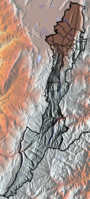
| Wetland | Location | Altitude (m) | Area (ha) | Notes | Image |
|---|---|---|---|---|---|
| Guaymaral y Torca | Usaquén Suba |
2547 | 73 | [3][4] | 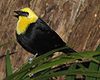 |
| La Conejera | Suba | 2544 | 58.9 | [5] | |
| Córdoba | Suba | 2548 | 40.51 | [6] |  |
| Tibabuyes Juan Amarillo |
Suba Engativá |
2539 | 222.58 | [7] |  |
| Jaboque | Engativá | 2539 | 148 | [8] | 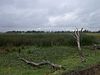 |
| Santa María del Lago | Engativá | 2549 | 12 | [9] |  |
| El Burro | Kennedy | 2541 | 18.84 | [10] |  |
| La Vaca | Kennedy | 2548 | 7.96 | [11] | |
| Techo | Techo, Kennedy | 2545 | 11.46 | [12] | |
| Capellanía | Fontibón | 2542 | 27.05 | [13] | |
| Meandro del Say | Fontibón Mosquera |
2548 | 13.6 | [14] | |
| Tibanica | Bosa Soacha |
2542 | 28.8 | [15] | |
| El Salitre | Barrios Unidos | 2558 | 6.4 | [16] | |
| La Isla | Bosa | 2550 | 7.7 | [17] | |
| La Florida | Funza | 2542 | 26 | [18] |  |
See also[]
- Biodiversity of Colombia
- List of flora and fauna named after the Muisca
- List of flora and fauna of the Eastern Hills, Bogotá
References[]
- ^ a b "Complejo de Humedales Urbanos del Distrito Capital de Bogotá". Ramsar Sites Information Service. Retrieved 9 January 2020.
- ^ Moreno et al., s.a., p.2
- ^ Humedal Guaymaral
- ^ Humedal Torca
- ^ Humedal La Conejera
- ^ Humedal Córdoba
- ^ Humedal Tibabuyes
- ^ Humedal Jaboque
- ^ Humedal Santa María del Lago
- ^ Humedal El Burro
- ^ Humedal La Vaca
- ^ Humedal Techo
- ^ Humedal Capellanía
- ^ Humedal Meandro del Say
- ^ Humedal Tibanica
- ^ Humedal El Salitre
- ^ Humedal La Isla
- ^ Humedal La Florida
Bibliography[]
- , and . s.a. Los Humedales de la Sabana de Bogotá: Área Importante para la Conservación de las Aves de Colombia y el Mundo, 1–38. AICAS. Accessed 2017-03-03.
- ; , and . s.a. Descripción general de los humedales de Bogotá D.C., 1–28. Sociedad Geográfica de Colombia. Accessed 2017-03-03.
- . 2013. Protected Areas in the City, Urban Wetlands of Bogotá. Cuadernos de Vivienda y Urbanismo 6. 80–103. Accessed 2017-03-03.
External links[]
| Wikimedia Commons has media related to Wetlands of Bogotá. |
- (in Spanish) Fundación Humedales de Bogotá
- (in Spanish) Conozca los 15 humedales de Bogotá - El Tiempo
| |||||||||||||||||||||||||||
| |||||||||||||||||||||||||||
| |||||||||||||||||||||||||||
| |||||||||||||||||||||||||||
| |||||||||||||||||||||||||||
| |||||||||||||||||||||||||||

 | Administrative subdivision in 20 localities | 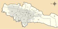 | |
|---|---|---|---|
| Metropolitan Area | |||
| Geography |
| ||
| |||
- Wetlands of Bogotá
- Ramsar sites in Colombia