Wooroolin, Queensland
| Wooroolin Queensland | |||||||||||||||
|---|---|---|---|---|---|---|---|---|---|---|---|---|---|---|---|
 Old church in Wooroolin, framed by jacarandas in bloom | |||||||||||||||
 Wooroolin The location of Wooroolin in Queensland | |||||||||||||||
| Coordinates | 26°24′35″S 151°48′58″E / 26.4097°S 151.8161°ECoordinates: 26°24′35″S 151°48′58″E / 26.4097°S 151.8161°E | ||||||||||||||
| Population | 315 (2016 census)[1] | ||||||||||||||
| • Density | 2.510/km2 (6.501/sq mi) | ||||||||||||||
| Postcode(s) | 4608 | ||||||||||||||
| Area | 125.5 km2 (48.5 sq mi) | ||||||||||||||
| Location |
| ||||||||||||||
| LGA(s) | South Burnett Region | ||||||||||||||
| State electorate(s) | Nanango | ||||||||||||||
| Federal division(s) | Maranoa | ||||||||||||||
| |||||||||||||||

Wooroolin is a town and a locality in the South Burnett Region, Queensland, Australia.[2][3] In the 2016 census, Wooroolin had a population of 315 people.[1]
Geography[]
Wooroolin is on the Bunya Highway, 243 kilometres (151 mi) north west of the state capital, Brisbane, and 17 km's North of the main town, Kingaroy
Immediately to the east of the town is the Wooroolin Wetland, which is classified as a palustrine wetland, a non-tidal, inland, seasonally flooded, vegetated swamp.[4]
History[]
Wooroolin Provisional School (also known as Wooroolin Lagoon Provisional School) opened on 18 February 1901 and become Wooroolin State School on 1 January 1909.[5][6]
Wooroolin West Provisional School opened on 2 April 1929; it closed at some time between 1944 and 1949.[6]
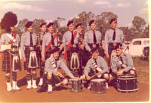
In 1961, Wooroolin hosted the Wooroolin – Tingoora R.S.L. Highland Gathering and Sports Day.[7]
At the 2006 census, Wooroolin had a population of 164.[8]
After successive floods in 2011 and 2013, the wetland burst its banks and Wooroolin was flooded for the first time in recorded history. As at 2015, the wetland was still completely full and resembled a large, shallow lake. Due to a bad drought in later years from 2015 to late 2020, the wetlands drained completely. Luckily for the tourists, 305 ml of rain fell across the area in November 2021, and filled up the wetlands in a matter of weeks for the first time in years.
Education[]
Wooroolin State School is a government primary (Prep-6) school for boys and girls at 34 Frederick Street (26°24′33″S 151°48′43″E / 26.4091°S 151.8120°E).[9][10] In 2017, the school had an enrolment of 44 students with 5 teachers (3 full-time equivalent) and 7 non-teaching staff (4 full-time equivalent).[11]
There are no secondary schools in Wooroolin. The nearest secondary schools are in Kingaroy and Murgon.[12]
Community groups[]
The Wooroolin branch of the Queensland Country Women's Association meets at Lot 41 Frederick Street.[13]
Notable people[]
- Galfry Gatacre CBE DSC DSO (1907–1983), Royal Australian Navy rear admiral and first-class cricketer
References[]
- ^ a b Australian Bureau of Statistics (27 June 2017). "Wooroolin (SSC)". 2016 Census QuickStats. Retrieved 20 October 2018.

- ^ "Wooroolin – town in South Burnett Region (entry 38127)". Queensland Place Names. Queensland Government. Retrieved 28 December 2018.
- ^ "Wooroolin – locality in South Burnett Region (entry 49595)". Queensland Place Names. Queensland Government. Retrieved 28 December 2018.
- ^ "Wooroolin Wetland: Fire and Biodiversity Management Plan (draft)" (PDF). Caroline Haskard Botanical and Natural Systems Services. May 2006. Retrieved 20 October 2009.
- ^ "Opening and closing dates of Queensland Schools". Queensland Government. Retrieved 18 April 2019.
- ^ a b Queensland Family History Society (2010), Queensland schools past and present (Version 1.01 ed.), Queensland Family History Society, ISBN 978-1-921171-26-0
- ^ "FROM the VAULT – Help to ID Police Pipe Band members in this photograph". Queensland Police Museum. 17 July 2018. Archived from the original on 27 December 2018. Retrieved 28 December 2018.
- ^ Australian Bureau of Statistics (25 October 2007). "Wooroolin (Kingaroy Shire) (State Suburb)". 2006 Census QuickStats. Retrieved 12 January 2009.
- ^ "State and non-state school details". Queensland Government. 9 July 2018. Archived from the original on 21 November 2018. Retrieved 21 November 2018.
- ^ "Wooroolin State School". Retrieved 21 November 2018.
- ^ "ACARA School Profile 2017". Archived from the original on 22 November 2018. Retrieved 22 November 2018.
- ^ "Queensland Globe". State of Queensland. Retrieved 27 December 2018.
- ^ "Branch Locations". Queensland Country Women's Association. Retrieved 26 December 2018.
External links[]
| Wikimedia Commons has media related to Wooroolin, Queensland. |
- Towns in Queensland
- South Burnett Region
- Localities in Queensland