Yatung
Yatung
ཤར་གསིང་མ་ · 下司马镇 Shasima, Xarsingma | |
|---|---|
| Xiasima | |
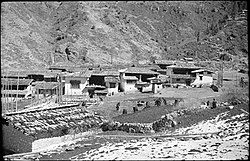 Upper Yatung, 1937 | |
 Yatung | |
| Coordinates: 27°28′55″N 88°54′26″E / 27.4819°N 88.9073°ECoordinates: 27°28′55″N 88°54′26″E / 27.4819°N 88.9073°E | |
| Country | China |
| Autonomous region | Tibet |
| Prefecture-level city | Xigazê |
| County | Yadong |
| Population | |
| • Total |
|
| • Major Nationalities | Tibetan |
| • Regional dialect | Tibetan language |
| Time zone | UTC+8 (CST) |

Yatung[1] or Yadong,[2] also known as Shasima (Tibetan: ཤར་གསིང་མ་, Wylie: shar gsing ma, THL: sharsingma, simplified Chinese: 下司马镇; traditional Chinese: 下司馬鎮; pinyin: Xiàsīmǎ Zhèn),[1][a] is the principal town in the Chumbi Valley or Yadong County in the Tibet Autonomous Region of China. It is also its admnistrative headquarters.
Name[]
The village is known locally as Shasima (Sharsingma) to the Tibetans, believed to be a Lepcha name.[6] During the British Raj era, it was called Yatung, the name having been transferred from another location called "Yatung" in the valley between the Jelep La and Rinchengang. The original location later came to be called Old Yatung.[1][7]
The Chinese administration of Tibet uses the name Yatung (often transliterated "Yadong" in Chinese pinyin) for the county, and the name Shasima for the town.
Geography[]

Yatung is at the confluence of the Khangphu Chu (Chinese: 康布麻曲; pinyin: Kāng bù má qū) and Tromo Chu (Chinese: 麻曲) rivers, which join here to form the Amo Chu river before it flows into Bhutan. Downstream along Amo Chu are further villages of Chumbi, Pipitang and Chema, the last of them four miles away from Yatung.[8]
The road to Sikkim's Jelep La and Nathu La passes takes off from Pipitang/Chema. Tibetans used to use this route to reach Kalimpong in British India, which provided trade marts for them.[3][9]
Origins[]
Originally there was a small village called Eusaka (also written as Yusa) on the bank of the Amo Chu river. During the Younghusband Expedition, the British troops camped on the high ground above the village. Younghusband named the location "New Chumbi", treating it as an outpost of Chumbi, which was then the most prominent town in the lower Chumbi Valley. He also had a bungalow house constructed at New Chumbi.[10][11] During the three years of British administration of the Chumbi Valley (1904–1908), the British administrator lived in the house and it came to function as the administrative headquarters of the Chumbi Valley. A hospital, a post-and-telegraph office (PTO) and a trade market also came to be located here.[12]
After the Chumbi Valley was transferred back to Tibet in 1908, the British government ruled that the British official would henceforth function as the "British Trade Agent at Yatung", thereby imparting the name Yatung to this location.[13] It was called Yatung–Shasima or "New Yatung" to distinguish it from the original Yatung.[1] But, over time, "Yatung" came to mean the new location.
See also[]
- List of towns and villages in Tibet
Notes[]
References[]
- ^ a b c d Richardson, Hugh. High Peaks, Pure Earth: Collected Writings on Tibetan History and Culture. Serindia Publications. p. 547. ISBN 978-0-906026-46-5. Retrieved 25 March 2021.
The area of the Trade Marts was enlarged, and the site in the Chumbi valley was confirmed at Shasima (New Yatung) instead of at Old Yatung which had proved quite unsuitable.
- ^ a b "Chumbi Valley". Encyclopedia Britannica. Retrieved 22 April 2021.
- ^ a b Easton, An Unfrequented High through Sikkim and Tibet (1928), p. 14: "The Chumbi valley is the highway for the Tibetans to Western civilisation by way of the marts of Kalimpong. At Chumbi or Yatung, which is also called Shashima, they meet the river Amo Chu and, turning half right, travel south-west over the passes Dzalep La or Nathu La to Sikkim and Kalimpong."
- ^ "Get off your high horse". China Daily. Retrieved 25 March 2021.
- ^ Krishnan, Ananth. "Tibet border town hopes for opening to India". India Today. Retrieved 25 March 2021.
- ^ Awasty, Indira (1978), Between Sikkim and Bhutan: The Lepchas and Bhutias of Pedong, B.R. Publishing Corporation, pp. 28–29, ISBN 978-81-7018-025-8: "According to one account the local name of Yatung is Shasima which is a word of Lepcha origin."
- ^ McKay, Tibet and the British Raj (1997), p. 87: "The original Yatung (which became known as Old Yatung) was a small village of no importance, located in a bleak and isolated valley off the main trade route."
- ^ McKay, Tibet and the British Raj (1997), p. 87.
- ^ Paul G. Hackett, Kalimpong, Gergan Dorje Tharchin, and his Mirror newspaper, Columbia University, retrieved 24 March 2021.
- ^ Waddell, Lhasa and its Mysteries (1905), p. 89: "This position, selected 9780 feet above the sea level, was christened "New Chumbi," and we moved there the following day, crossing to the left bank by a fine cantilever bridge, with a guard-house at one end. Below our camp is the pretty village of Eusaka, amidst willows and pines, and beyond it the small monastery of Bakcham on a terrace above the river..."
- ^ McKay, Tibet and the British Raj (1997), p. 87: "The long, low-roofed Yatung Trade Agents' bungalow was erected during the Younghusband mission."
- ^ Fader, Called from Obscurity (2002), p. 72.
- ^ Viceroyalty of His Excellency the Earl of Minto, Vol. III, Simla: Government Monotype Press, 1910, p. 70 – via archive.org: 'On the 28th January the Political Officer in Sikkim was informed by the Government of India that the designation of the Assistant Political Officer in Chumbi would in future be "British Trade Agent at Yatung".'
Bibliography[]
- Bell, Charles (1924), Tibet Past and Present (First ed.), Oxford University Press
- 1924 'first edition' reprinted by Asian Educational Services
- Bell, Charles (1992), Tibet Past and Present, Motilal Banarsidass Publ., ISBN 978-81-208-1048-8
- Easton (1928), An Unfrequented High through Sikkim and Tibet, London: The Scholartis Press – via archive.org
- Fader, H. Louis (2002), Called from Obscurity: The Life and Times of a True Son of Tibet, God's Humble Servant from Poo, Gergan Dorje Tharchin, Vol. 2, Tibet Mirror Press, ISBN 978-99933-922-0-0
- McKay, Alex (1997), Tibet and the British Raj: The Frontier Cadre, 1904-1947, Psychology Press, ISBN 978-0-7007-0627-3
- Rawat, Bhawan Singh (2009), Travails of Border Trade (PDF), Munsayri, Pithoragarh: Malla Johr Vikas Samiti – via claudearpi.net
- Waddell, L. Austin (1905), Lhasa and its Mysteries, London: John Murray – via archive.org
- Younghusband, Francis (1910). India and Tibet. London: John Murray.
External links[]
- Claude Arpi, Trading with India: The Indian Trade Agencies in Tibet, claudearpi.net, 2016.
- Populated places in Shigatse
- Township-level divisions of Tibet
- Yadong County