Yadong County
Yadong County
亚东县 • གྲོ་མོ་རྫོང་། | |
|---|---|
 | |
 Location of Yadong County (red) within Shigatse City (yellow) and the Tibet Autonomous Region | |
 Yadong Location of the seat in the Tibet Autonomous Region | |
| Coordinates (Yadong County government): 27°29′10″N 88°54′26″E / 27.4861°N 88.9071°ECoordinates: 27°29′10″N 88°54′26″E / 27.4861°N 88.9071°E | |
| Country | People's Republic of China |
| Province | Tibet Autonomous Region |
| Prefecture-level city | Shigatse |
| Seat | Shasima |
| Time zone | UTC+8 (China Standard) |

| Yadong County | |||||||
|---|---|---|---|---|---|---|---|
| Chinese name | |||||||
| Simplified Chinese | 亚东县 | ||||||
| Traditional Chinese | 亞東縣 | ||||||
| |||||||
| Alternative Chinese name | |||||||
| Simplified Chinese | 卓木县 | ||||||
| Traditional Chinese | 卓木縣 | ||||||
| |||||||
| Second alternative Chinese name | |||||||
| Simplified Chinese | 绰莫县 | ||||||
| Traditional Chinese | 綽莫縣 | ||||||
| |||||||
| Tibetan name | |||||||
| Tibetan | གྲོ་མོ་རྫོང༌། | ||||||
| |||||||
Yadong County (Chinese: 亚东县; pinyin: Yà dōng xiàn; Wade–Giles: Ya-tung xian), also known by its Tibetan name Dromo/Tromo County (Tibetan: གྲོ་མོ་རྫོང༌།, Wylie: gro mo rdzong, ZYPY: Chomo Zong)[1][2] is a frontier county and trade-market of the Tibet region of China, part of its Shigatse Prefecture.
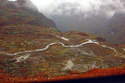
Yadong County is coextensive with the Chumbi valley that extends south into the Himalayas between Sikkim and Bhutan. It shares boundaries with both India and Bhutan. It covers about 4,306 square kilometers with a population of 10,000. Its headquarters is Shasima (or "Yatung").
Geography[]
The town of Dromo (Yadong) 27°29′22″N 88°54′21″E / 27.48944°N 88.90583°E is very close to the borders of both the Indian state of Sikkim and Bhutan and has a hotel, a guest house, some government offices and army barracks.[3]
Local specialities include Dromo fish and barley wine while the main tourist sites are , and Kangbu Hotspring. Yadong is connected to the Indian state of Sikkim via the Nathu La.
As part of the China Western Development strategy, the Chinese government planned to extend the Qinghai–Tibet Railway from Lhasa to Yadong near the Nathu La that marks the disputed China–India border.[4]
History[]
According to the Convention of Calcutta of 1890–94 signed by Great Britain and Qing dynasty China, the market at Dromo was opened to India. At that time there was a wall-like structure across the valley's stream extending part way up each side of the valley thus blocking the road to the Tibetan capital, Lhasa. This was the demarcation line that British subjects were forbidden to cross and was manned by 20 Tibetan soldiers under a sergeant along with three Chinese officials.[5] The construction of the wall was reported to be one of the incidents that led to the British invasion of Tibet in 1904. According to the resulting Treaty of Lhasa, a British trade-agent was to be stationed at Yadong.[6]
Administrative divisions[]

Yadong County administers the following two towns and five townships:[7]
- Shasima (Tibetan: ཤར་གསིང་མ་, Wylie: Sharsingma; Chinese: 下司马镇; also referred to as "Yatung" in English)
- Phari (Tibetan: ཕག་རི, Wylie: Phag ri་; Chinese: 帕里镇)
- (སྒེར་རུ་; Chinese: 吉汝乡)
- (ཁམ་བུ་; Chinese: 康布乡)
- (རུད་སྲུངས་སྒང་; Chinese: 上亚东乡)
- (དུད་སྣ་; Chinese: 堆纳乡)
- Xiadromo Township (གྲོ་མོ་སྨད་; Chinese: 下亚东乡; also known as "Xiayadong" or "Dromo Mechü")
References[]
- ^ BDRCཨང་། (G2172), Buddhist Tibetan Resource Centre, retrieved 25 March 2021.
- ^ Goldstein, Melvyn C. (2001), The New Tibetan-English Dictionary of Modern Tibetan, Univ of California Press, p. 204, ISBN 978-0-520-20437-9
- ^ Buckley, Michael and Strauss, Robert. Tibet: a travel survival kit, p. 163. (1986) Lonely Planet Publications, Victoria, Australia. ISBN 0-908086-88-1.
- ^ Extension plans. Retrieved June 28, 2006
- ^ Sandberg, Graham (1901). An Itinerary of the Route from Sikkim to Lhasa. Calcutta: Baptist Mission Press. p. 7.
- ^ One or more of the preceding sentences incorporates text from a publication now in the public domain: Chisholm, Hugh, ed. (1911). "Yatung". Encyclopædia Britannica. Vol. 28 (11th ed.). Cambridge University Press. p. 908.
- ^ 2020年统计用区划代码(亚东县) [2020 Statistical Division Codes (Yadong County)] (in Chinese). National Bureau of Statistics of China. 2020. Archived from the original on 2021-10-10. Retrieved 2021-10-10.
External links[]
| County-level divisions |
|  | ||||
|---|---|---|---|---|---|---|
| Settlements | ||||||
| Landmarks |
| |||||
| Geography | ||||||
| Transport | ||||||
- Counties of Tibet
- Shigatse