Cona County
Cona County
错那县 • མཚོ་སྣ་རྫོང་། | |
|---|---|
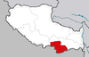
 Location of Cona County (red) within Shannan Prefecture (yellow) and the Tibet A.R. | |
 Tsona Dzong Location of the seat in the Tibet A.R. | |
| Coordinates: 27°59′19″N 91°57′31″E / 27.98861°N 91.95861°E | |
| Country | People's Republic of China |
| Autonomous region | Tibet |
| Prefecture-level city | Shannan |
| Seat | Tsona Dzong |
| Time zone | UTC+8 (China Standard) |


Cona County (Tibetan: མཚོ་སྣ་རྫོང་, Wylie: mtsho sna rdzong, ZYPY: Cona Zong; simplified Chinese: 错那县; traditional Chinese: 錯那縣; pinyin: Cuònà Xiàn) is a county in Shannan perfecture in southern part of Tibet Autonomous Region in People's Republic of China. This county lies immediate north of disputed India-Tibet border demarcated by the Line of Actual Control (LAC).
The county is covered by valley of river which is a tributary of Tawang Chu.
Tsona Dzong (a historical fortress), the main town and the headquarters of the Cona County, is on the bank of Tsona Chu. It is 34 km north of LAC (Bum La Pass).[1] Earlier Tsona Dzong was connected to the Indian-administered Tawang in Arunachal Pradesh via an 80-km-route via the Bum La and Milakatong La passes.
See also[]
References[]
- ^ Indo-China Border Trade, Department of Trade & Commerce, Government of Arunachal Pradesh, retrieved 13 July 2020.
External links[]
- Cona County Annals
- Cona County marked on OpenStreetMap
| show Authority control |
|---|
Coordinates: 27°59′19″N 91°57′31″E / 27.98861°N 91.95861°E
This Shannan, Tibet location article is a stub. You can help Wikipedia by . |
- Counties of Tibet
- Shannan, Tibet
- Territorial disputes of China
- Territorial disputes of India
- Shannan, Tibet geography stubs