1968 Pacific typhoon season

From Wikipedia, the free encyclopedia
1968 Pacific typhoon season
1968 Pacific typhoon season summary map.png
Season summary map
Seasonal boundaries
First system formedJanuary 20, 1968
Last system dissipatedDecember 7, 1968
Strongest storm
NameAgnes
 • Maximum winds280 km/h (175 mph)
(1-minute sustained)
 • Lowest pressure900 hPa (mbar)
Seasonal statistics
Total depressions39
Total storms28
Typhoons20
Super typhoons4 (unofficial)
Total fatalities148
Total damageUnknown
Related articles
Pacific typhoon seasons
1966, 1967, 1968, 1969, 1970

The 1968 Pacific typhoon season has no official bounds; it ran year-round in 1968, but most tropical cyclones tend to form in the northwestern Pacific Ocean between June and December. These dates conventionally delimit the period of each year when most tropical cyclones form in the northwestern Pacific Ocean.

The scope of this article is limited to the Pacific Ocean, north of the equator and west of the International Date Line. Storms that form east of the date line and north of the equator are called hurricanes; see 1968 Pacific hurricane season. Tropical Storms formed in the entire west pacific basin were assigned a name by the Joint Typhoon Warning Center. Tropical depressions in this basin have the "W" suffix added to their number. Tropical depressions that enter or form in the Philippine area of responsibility are assigned a name by the Philippine Atmospheric, Geophysical and Astronomical Services Administration or PAGASA. This can often result in the same storm having two names.

Systems[]

31 tropical depressions formed this year in the Western Pacific, of which 27 became tropical storms. 20 storms reached typhoon intensity, of which 4 reached super typhoon strength. No storms this season caused significant damage or deaths.

CMA Tropical Depression 01[]

Tropical depression (CMA)
Temporary cyclone north.svg CMA TD 01 1968 track.png
DurationJanuary 21 – January 23
Peak intensity55 km/h (35 mph) (10-min)  1002 hPa (mbar)

A tropical depression formed to the northwest of Palau. Moving north-northwest, the depression degenerated to a remnant low as it made a counterclockwise direction before dissipating.

This depression was not recognized by the JMA, but the CMA.

Tropical Depression 01W (Asiang)[]

Tropical depression (JMA)
Tropical storm (SSHWS)
01W 1968-02-28.png 01W 1968 track.png
DurationFebruary 28 – March 2
Peak intensity65 km/h (40 mph) (1-min)  999 hPa (mbar)

Typhoon Jean[]

Typhoon (JMA)
Category 3-equivalent typhoon (SSHWS)
Jean 1968.png Jean 1968 track.png
DurationApril 5 – April 19
Peak intensity205 km/h (125 mph) (1-min)  935 hPa (mbar)

Typhoon Kim (Biring)[]

Typhoon (JMA)
Category 3-equivalent typhoon (SSHWS)
Kim 1968-06-04.png Kim 1968 track.png
DurationMay 28 – June 5
Peak intensity185 km/h (115 mph) (1-min)  950 hPa (mbar)

Tropical Depression 04W[]

Tropical depression (JMA)
Tropical depression (SSHWS)
Temporary cyclone north.svg 04W 1968 track.png
DurationJune 2 – June 2
Peak intensity45 km/h (30 mph) (1-min)  1006 hPa (mbar)

Tropical Depression 05W[]

Tropical depression (JMA)
Tropical storm (SSHWS)
05W 1968-06-07.png 05W 1968 track.png
DurationJune 4 – June 8
Peak intensity65 km/h (40 mph) (1-min)  1002 hPa (mbar)

Typhoon Lucy (Konsing)[]

Typhoon (JMA)
Category 3-equivalent typhoon (SSHWS)
Lucy 1968-06-30.png Lucy 1968 track.png
DurationJune 26 – July 3
Peak intensity205 km/h (125 mph) (1-min)  935 hPa (mbar)

Typhoon Mary[]

Typhoon (JMA)
Category 4-equivalent typhoon (SSHWS)
MaryJul2319680638UTCESSA5.gif Mary 1968 track.png
DurationJuly 19 – August 3
Peak intensity240 km/h (150 mph) (1-min)  925 hPa (mbar)

Severe Tropical Storm Nadine (Didang)[]

Severe tropical storm (JMA)
Tropical storm (SSHWS)
Nadine 1968-07-25.png Nadine 1968 track.png
DurationJuly 20 – July 28
Peak intensity110 km/h (70 mph) (1-min)  970 hPa (mbar)

Tropical Storm Olive (Edeng)[]

Tropical storm (JMA)
Tropical storm (SSHWS)
Olive 1968-07-25.png Olive 1968 track.png
DurationJuly 21 – July 28
Peak intensity85 km/h (50 mph) (1-min)  988 hPa (mbar)

CMA Tropical Depression 11[]

Tropical depression (CMA)
Temporary cyclone north.svg CMA TD 11 1968 track.png
DurationJuly 29 – July 31
Peak intensity55 km/h (35 mph) (10-min)  992 hPa (mbar)

CMA Tropical Depression 12[]

Tropical depression (CMA)
Temporary cyclone north.svg CMA TD 12 1968 track.png
DurationJuly 30 – July 31
Peak intensity55 km/h (35 mph) (10-min)  996 hPa (mbar)

CMA Tropical Depression 13[]

Tropical depression (CMA)
Temporary cyclone north.svg CMA TD 13 1968 track.png
DurationAugust 3 – August 6
Peak intensity45 km/h (30 mph) (10-min)  1003 hPa (mbar)

Severe Tropical Storm Polly[]

Severe tropical storm (JMA)
Tropical storm (SSHWS)
Sat196808060549zPolly.png Polly 1968 track.png
DurationAugust 3 – August 17
Peak intensity100 km/h (65 mph) (1-min)  965 hPa (mbar)

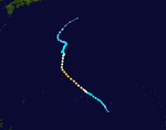
Tropical Storm Polly dropped heavy rains on the southern islands of Japan. 112 people were killed and 21 were missing from the floods and landslides caused by Polly's heavy rains.[1]

On August 18, two sightseeing buses were involved in the landslide in Shirakawa, Gifu, it fell to the Hida River, and 95 persons died and 9 persons became missing.

Tropical Depression 11W[]

Tropical depression (JMA)
Tropical depression (SSHWS)
Temporary cyclone north.svg 11W 1968 track.png
DurationAugust 7 – August 7
Peak intensity35 km/h (25 mph) (10-min) 

Severe Tropical Storm Rose (Gloring)[]

Severe tropical storm (JMA)
Tropical storm (SSHWS)
Temporary cyclone north.svg Rose 1968 track.png
DurationAugust 9 – August 13
Peak intensity110 km/h (70 mph) (1-min)  970 hPa (mbar)

CMA Tropical Depression 16[]

Tropical depression (CMA)
Temporary cyclone north.svg CMA TD 16 1968 track.png
DurationAugust 9 – August 9
Peak intensity35 km/h (25 mph) (10-min)  999 hPa (mbar)

Typhoon Shirley (Huaning)[]

Typhoon (JMA)
Category 1-equivalent typhoon (SSHWS)
ESSA 6 Typhoon Shirley 11.21 a.m. on August 21,1968.jpg Shirley 1968 track.png
DurationAugust 14 – August 24
Peak intensity120 km/h (75 mph) (1-min)  960 hPa (mbar)

Severe Tropical Storm Trix (Isang)[]

Severe tropical storm (JMA)
Tropical storm (SSHWS)
Trix 1968-08-29.png Trix 1968 track.png
DurationAugust 22 – August 29
Peak intensity100 km/h (65 mph) (1-min)  980 hPa (mbar)

Tropical Storm Trix struck the southern islands of Kyūshū and Shikoku. Heavy flooding killed 25 people and left 2 missing.[1]

CMA Tropical Depression 18[]

Tropical depression (CMA)
Temporary cyclone north.svg CMA TD 18 1968 track.png
DurationAugust 23 – August 24
Peak intensity45 km/h (30 mph) (10-min)  1000 hPa (mbar)

Severe Tropical Storm Virginia[]

Severe tropical storm (JMA)
Tropical storm (SSHWS)
Virginia 1968-08-25.png Virginia 1968 track.png
DurationAugust 24 – August 26
(exited basin)
Peak intensity95 km/h (60 mph) (1-min)  990 hPa (mbar)

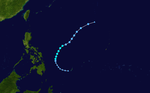
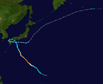
Virginia was first noticed near the International Date Line, about 500 kilometers (310 mi) northwest of Midway Islands. The system organized and the first advisory was issued on August 25 at 0006Z, with winds of 35 knots (40 mph). 18 hours later, Virginia crossed the date line, with winds of 50 knots (60 mph). It later became extratropical on August 27 in the Gulf of Alaska.

Typhoon Wendy (Lusing)[]

Typhoon (JMA)
Category 5-equivalent super typhoon (SSHWS)
WendySep119680631UTCESSA5.gif Wendy 1968 track.png
DurationAugust 27 – September 10
Peak intensity260 km/h (160 mph) (1-min)  920 hPa (mbar)

Tropical Storm Wendy, which formed on August 28 in the open Western Pacific, quickly intensified to a peak of 160 mph winds on the 31st. It steadily weakened as it moved westward, and passed by southern Taiwan on September 5 as a minimal typhoon. Wendy continued to weaken, and after crossing the South China Sea, Wendy dissipated over northern Vietnam on the 9th.

Typhoon Agnes[]

Typhoon (JMA)
Category 5-equivalent super typhoon (SSHWS)
AgnesSep119680631UTCESSA5.png Agnes 1968 track.png
DurationAugust 27 – September 10
Peak intensity280 km/h (175 mph) (1-min)  900 hPa (mbar)

Typhoon which did not approach land closely. The typhoon was one of two Category 5 cyclones to be named Agnes, the other one being in 1952.

Typhoon Bess[]

Typhoon (JMA)
Category 1-equivalent typhoon (SSHWS)
Bess 1968-09-04.png Bess 1968 track.png
DurationAugust 31 – September 10
Peak intensity120 km/h (75 mph) (1-min)  965 hPa (mbar)

CMA Tropical Depression 24[]

Tropical depression (CMA)
Temporary cyclone north.svg CMA TD 24 1968 track.png
DurationSeptember 5 – September 8
Peak intensity55 km/h (35 mph) (10-min)  990 hPa (mbar)

Typhoon Carmen[]

Typhoon (JMA)
Category 3-equivalent typhoon (SSHWS)
Carmen 1968-09-19.png Carmen 1968 track.png
DurationSeptember 15 – September 24
Peak intensity205 km/h (125 mph) (1-min)  935 hPa (mbar)

Typhoon Della (Maring)[]

Typhoon (JMA)
Category 4-equivalent typhoon (SSHWS)
Della 1968-09-22.png Della 1968 track.png
DurationSeptember 11 – September 25
Peak intensity220 km/h (140 mph) (1-min)  930 hPa (mbar)

Typhoon Della struck Kyūshū Island in southern Japan with winds of 100 mph. Della killed 11 throughout southern Japan.[1]

Typhoon Elaine (Nitang)[]

Typhoon (JMA)
Category 5-equivalent super typhoon (SSHWS)
Elaine 1968-09-27.png Elaine 1968 track.png
DurationSeptember 22 – October 2
Peak intensity280 km/h (175 mph) (1-min)  910 hPa (mbar)

Super Typhoon Elaine, after peaking at 175 mph winds, weakened to hit extreme northern Luzon on September 28 as a 130 mph typhoon. It continued to the northwest, and after hitting southeastern China as a minimal tropical storm Elaine dissipated on October 1.

Typhoon Faye[]

Typhoon (JMA)
Category 5-equivalent super typhoon (SSHWS)
FayeOct619680346UTCESSA7.gif Faye 1968 track.png
DurationSeptember 30 – October 10
Peak intensity270 km/h (165 mph) (1-min)  915 hPa (mbar)

Typhoon Gloria (Osang)[]

Typhoon (JMA)
Category 2-equivalent typhoon (SSHWS)
Typhoongloria1967.png Gloria 1968 track.png
DurationOctober 12 – October 24
Peak intensity165 km/h (105 mph) (1-min)  955 hPa (mbar)

CMA Tropical Depression 29[]

Tropical depression (CMA)
Temporary cyclone north.svg CMA TD 29 1968 track.png
DurationOctober 12 – October 12
Peak intensity45 km/h (30 mph) (10-min)  1006 hPa (mbar)

Severe Tropical Storm Hester[]

Severe tropical storm (JMA)
Tropical storm (SSHWS)
Hester 1968-10-19.png Hester 1968 track.png
DurationOctober 15 – October 21
Peak intensity100 km/h (65 mph) (1-min)  995 hPa (mbar)

Typhoon Irma[]

Typhoon (JMA)
Category 1-equivalent typhoon (SSHWS)
IrmaOct2319680400UTCESSA7.gif Irma 1968 track.png
DurationOctober 18 – October 25
Peak intensity150 km/h (90 mph) (1-min)  955 hPa (mbar)

Typhoon Judy (Paring)[]

Typhoon (JMA)
Category 4-equivalent typhoon (SSHWS)
JudyOct2919680540UTCESSA7.gif Judy 1968 track.png
DurationOctober 21 – November 4
Peak intensity220 km/h (140 mph) (1-min)  930 hPa (mbar)

Typhoon Kit[]

Typhoon (JMA)
Category 1-equivalent typhoon (SSHWS)
KitNov319680430UTCESSA7.gif Kit 1968 track.png
DurationOctober 26 – November 5
Peak intensity130 km/h (80 mph) (1-min)  960 hPa (mbar)

Typhoon Lola[]

Typhoon (JMA)
Category 3-equivalent typhoon (SSHWS)
Lola 1968-11-10.png Lola 1968 track.png
DurationNovember 5 – November 12
Peak intensity195 km/h (120 mph) (1-min)  940 hPa (mbar)

Typhoon Mamie (Reming)[]

Typhoon (JMA)
Category 1-equivalent typhoon (SSHWS)
MamieNov2319680725UTCESSA7.gif Mamie 1968 track.png
DurationNovember 9 – November 25
Peak intensity120 km/h (75 mph) (1-min)  975 hPa (mbar)

Typhoon Nina (Seniang)[]

Typhoon (JMA)
Category 1-equivalent typhoon (SSHWS)
Nina 1968-11-27.png Nina 1968 track.png
DurationNovember 15 – November 29
Peak intensity130 km/h (80 mph) (1-min)  960 hPa (mbar)

Typhoon Ora (Toyang)[]

Typhoon (JMA)
Category 4-equivalent typhoon (SSHWS)
Ora1968eastofPhilippinesESSA7.gif Ora 1968 track.png
DurationNovember 19 – November 30
Peak intensity220 km/h (140 mph) (1-min)  930 hPa (mbar)

A typhoon that made landfall in the Philippines as a category 1 and impacted most of the northern Philippines as a tropical storm.

Storm names[]

Western North Pacific tropical cyclones were named by the Joint Typhoon Warning Center. The first storm of 1968 was named Jean and the final one was named Ora.

  • Agnes 17W
  • Bonnie 18W
  • Carmen 19W
  • Della 20W
  • Elaine 21W
  • Faye 22W
  • Gloria 23W
  • Hester 24W
  • Irma 25W
  • Judy 26W
  • Kit 27W
  • Lola 28W
  • Mamie 29W
  • Nina 30W
  • Ora 31W
  • Phyllis
  • Rita
  • Susan
  • Tess
  • Viola
  • Winnie
  • Alice
  • Betty
  • Cora
  • Doris
  • Elsie
  • Flossie
  • Grace
  • Helen
  • Ida
  • June
  • Kathy
  • Lorna
  • Marie
  • Nancy
  • Olga
  • Pamela
  • Ruby
  • Sally
  • Therese
  • Violet
  • Wilda
  • Anita
  • Billie
  • Clara
  • Dot
  • Ellen
  • Fran
  • Georgia
  • Hope
  • Iris
  • Joan
  • Kate
  • Louise
  • Marge
  • Nora
  • Opal
  • Patsy
  • Ruth
  • Sarah
  • Thelma
  • Vera
  • Wanda
  • Amy
  • Babe
  • Carla
  • Dinah
  • Emma
  • Freda
  • Gilda
  • Harriet
  • Ivy
  • Jean 2W
  • Kim 3W
  • Lucy 6W
  • Mary 7W
  • Nadine 8W
  • Olive 9W
  • Polly 10W
  • Rose 12W
  • Shirley 13W
  • Trix 14W
  • Virginia 15W
  • Wendy 16W

Philippines[]

Asiang Biring Konsing Didang Edeng
Gloring Huaning Isang Lusing Maring
Nitang Osang Paring Reming Seniang
Toyang Undang (unused) Welpring (unused) Yoning (unused)
Auxiliary list
Aring (unused)
Basiang (unused) Kayang (unused) Dorang (unused) Enang (unused) Grasing (unused)

The Philippine Atmospheric, Geophysical and Astronomical Services Administration uses its own naming scheme for tropical cyclones in their area of responsibility. PAGASA assigns names to tropical depressions that form within their area of responsibility and any tropical cyclone that might move into their area of responsibility. Should the list of names for a given year prove to be insufficient, names are taken from an auxiliary list, the first 6 of which are published each year before the season starts. Names not retired from this list will be used again in the 1972 season. This is the same list used for the 1964 season, except for Didang, which replaced Dading. PAGASA uses its own naming scheme that starts in the Filipino alphabet, with names of Filipino female names ending with "ng" (A, B, K, D, etc.). Names that were not assigned/going to use are marked in gray.

Season effects[]

This table will list all the storms that developed in the northwestern Pacific Ocean west of the International Date Line and north of the equator during 1968. It will include their intensity, duration, name, areas affected, deaths, missing persons (in parentheses), and damage totals. Classification and intensity values will be based on estimations conducted by the JMA, however due to lack of information around this time sustained winds were recorded by the JTWC. All damage figures will be in 1969 USD. Damages and deaths from a storm will include when the storm was a precursor wave or an extratropical low.

Name Dates active Peak classification Sustained
wind speeds
Pressure Areas affected Damage
(USD)
Deaths Refs
TD January 20 – 26 Tropical depression Not specified 1,002 hPa (29.59 inHg) Palau None None
01W (Asiang) February 26 – March 2 Tropical depression 65 km/h (40 mph) 1,000 hPa (29.53 inHg) Palau None None
TD March 1 Tropical depression Not specified 1,011 hPa (29.85 inHg) None None None
Jean April 15 – 19 Typhoon 205 km/h (125 mph) 935 hPa (27.61 inHg) Mariana Islands None None
TD May 1 – 2 Tropical depression Not specified 1,012 hPa (29.88 inHg) Wake Island None None
TD May 19 Tropical depression Not specified 1,007 hPa (29.74 inHg) None None None
Kim (Biring) May 28 – June 5 Typhoon 185 km/h (115 mph) 950 hPa (28.05 inHg) Caroline Islands None None
TD May 31 Tropical depression Not specified 1,010 hPa (29.83 inHg) Caroline Islands None None
04W June 2 – 3 Tropical depression 45 km/h (30 mph) 1,006 hPa (29.71 inHg) Caroline Islands None None
05W June 3 – 8 Tropical depression 65 km/h (40 mph) 1,006 hPa (29.71 inHg) Mariana Islands None None
TD June 23 – 26 Tropical depression Not specified 1,008 hPa (29.77 inHg) Philippines None None
Lucy (Konsing) June 26 – July 3 Typhoon 205 km/h (125 mph) 935 hPa (27.61 inHg) Ryukyu Islands None None
TD June 26 – 28 Tropical depression Not specified 1,006 hPa (29.71 inHg) Vietnam None None
TD June 26 – 28 Tropical depression Not specified 1,007 hPa (29.74 inHg) Philippines None None
TD June 27 – 28 Tropical depression Not specified 1,008 hPa (29.77 inHg) Taiwan None None
TD June 28 Tropical depression Not specified 1,010 hPa (29.83 inHg) None None None
TD July 11 – 14 Tropical depression Not specified 1,008 hPa (29.77 inHg) None None None
TD July 12 Tropical depression Not specified 1,008 hPa (29.77 inHg) Philippines None None
TD July 16 – 18 Tropical depression Not specified 1,006 hPa (29.71 inHg) Mariana Islands None None
Mary July 19 – August 3 Typhoon 240 km/h (150 mph) 925 hPa (27.32 inHg) Mariana Islands, Japan Unknown Unknown
Nadine (Didang) July 20 – 28 Severe tropical storm 110 km/h (70 mph) 970 hPa (28.64 inHg) Philippines, Taiwan None None
Olive (Edeng) July 21 – 28 Tropical storm 85 km/h (55 mph) 988 hPa (29.18 inHg) Philippines None None
TD July 27 – August 1 Tropical depression Not specified 992 hPa (29.29 inHg) None None None
TD July 28 – August 1 Tropical depression Not specified 1,002 hPa (29.59 inHg) None None None
TD July 30 – August 2 Tropical depression Not specified 996 hPa (29.41 inHg) None None None
Season aggregates
61 systems January 20 – December 30, 1968 280 km/h (175 mph) 895 hPa (26.43 inHg) >$216 million >1,077

References[]

External links[]

Retrieved from ""