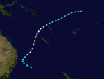
1991–92 South Pacific cyclone season
| 1991–92 South Pacific cyclone season | |
|---|---|
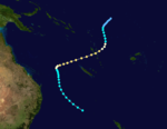
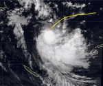
 Season summary map | |
| Seasonal boundaries | |
| First system formed | November 13, 1991 |
| Last system dissipated | May 2, 1992 |
| Strongest storm | |
| Name | Fran |
| • Maximum winds | 205 km/h (125 mph) (10-minute sustained) |
| • Lowest pressure | 920 hPa (mbar) |
| Seasonal statistics | |
| Total depressions | 14 |
| Tropical cyclones | 11 |
| Severe tropical cyclones | 7 |
| Total fatalities | 21 |
| Total damage | ≥ $360 million (1992 USD) |
| Related articles | |
The 1991–92 South Pacific cyclone season was an above average tropical cyclone season, with eleven tropical cyclones occurring within the South Pacific basin between 160°E and 120°W. The first tropical cyclone of the season was first noted on November 13, 1991, while the last tropical cyclone dissipated on May 2, 1992. During the season at least 21 people were killed by tropical cyclones, while Tropical Cyclones Cliff and Innis were the only tropical cyclones not to cause any damage to any country in the Southern Pacific.
During the season, tropical cyclones were monitored by the Tropical Cyclone Warning Centers (TCWC) in Nadi, Fiji, and in Wellington, New Zealand.[A 1] Whilst tropical cyclones that moved or formed to the west of 160°E were monitored as a part of the Australian region by the Australian Bureau of Meteorology. Both the United States Joint Typhoon Warning Center (JTWC) and the Naval Western Oceanography Center (NWOC) issued unofficial warnings within the southern Pacific. The JTWC issued warnings between 160°E and the International Date Line whilst the NWOC issued warnings for tropical cyclones forming between the International Date Line and the coasts of the Americas. Both the JTWC and the NWOC designated tropical cyclones with a number and a P suffix with numbers assigned in order to tropical cyclones developing within the whole of the South Pacific. the FMS and TCWC Wellington both use the Australian Tropical Cyclone Intensity Scale, and measure windspeeds over a period of ten minutes, while the JTWC and the NWOC measured sustained winds over a period of one minute which are compared to the Saffir–Simpson hurricane wind scale.
Seasonal summary[]

During the season a significant increase in the amount of tropical cyclones occurring within the South Pacific basin was observed, with eleven tropical cyclones occurring within the basin during the season compared to three during the previous season.[1][2] This increase was attributed to a mature El Niño episode, that had started developing towards the end of the previous season.[2][3] During the season the major areas of tropical cyclogenesis were shifted eastwards, from their mean position towards the more central parts of Pacific.[1] The first tropical cyclone of the season was first noted as a tropical depression on November 13, before it was named Tia during November 16, after it had become a category 1 tropical cyclone on the Australian tropical cyclone intensity scale.[4][5] Over the next day the system rapidly intensified into a category 3 severe tropical cyclone and affected the Solomon Islands of Tikopia and Anuta while near its peak intensity.[4][5] Tia subsequently started to weaken during November 19, as it became the first of six tropical cyclones to affect Vanuatu during the season.[1]
The names: Tia, Val, Wasa, Betsy, Esau and Fran were later retired from the tropical cyclone naming lists.[6] On July 1, 1992, the New Zealand Meteorological Service was split in two and became the Meteorological Service of New Zealand and the National Institute of Water and Atmospheric Research.[7]
Systems[]
Severe Tropical Cyclone Tia[]
| Category 3 severe tropical cyclone (Australian scale) | |
| Category 2 tropical cyclone (SSHWS) | |
  | |
| Duration | November 13 – November 21 |
|---|---|
| Peak intensity | 140 km/h (85 mph) (10-min) 960 hPa (mbar) |
On November 13, the FMS started to monitor a tropical depression that had developed within the South Pacific Convergence Zone, to the northeast of the Solomon Islands.[4][8] Over the next few days the system gradually developed further within an area of light winds in the upper troposphere, before the JTWC designated it as 03P early on November 15, after it had become equivalent to a tropical storm.[9][10] During that day the system's upper-level outflow characteristics became more favourable for further development, before the FMS named the system Tia early the next day after it had developed into a Category 1 tropical cyclone.[4] Later that day because of a developing northerly steering current, the system slowed down and undertook a small anticlockwise loop before starting to move towards the southwest and rapidly intensify. After rapidly intensifying throughout November 16 and 17, Tia passed within 55 km (35 mi) of Anuta Island at around 1800 UTC on November 17, before passing near Tikopia Island six hours later. As Tia moved near Tikopia, the FMS reported that the system had reached its peak intensity as a category 3 severe tropical cyclone with 10-minute sustained windspeeds of 140 km/h (85 mph).[4] During November 18, Tia started to gradually weaken under the influence of cooler sea surface temperatures and strengthening vertical windshear, while it moved southwards under the influence of a strengthening upper level northerly wind flow.[1][8] Over the next 24 hours, the system continued to move southwards and passed within 150 km (95 mi) of Vanuatu's Banks Islands, while gradually weakening further.[4] Tia subsequently degenerated into a tropical depression during November 20, before it was last noted during the next day, as it crossed a part of its former track where it had been producing hurricane-force windspeeds a few days earlier.[4][10][5]
Apart from extensive damage on the Solomon Islands of Anuta and Tikopia which directly lay in Tia's path, the overall effect of the cyclone was minimal.[4] More than 1000 people were left homeless on Tikopia, after 90% of all dwellings were completely destroyed while the remaining 10% had either walls destroyed or roofs blown off.[1] The cyclone also destroyed seven of the eight church buildings and all but one of the classroom buildings belonging to the two primary schools while food crops were completely destroyed with all coconut trees either blown down or uprooted.[1] High seas and waves caused extensive damage to the coasts and flooded low-lying areas, salinating food crops such as taro and destroyed the water supply system on the island.[4] As a result, Tikopia was declared a disaster area by the Solomon Islands National Disaster Council.[4] Sustained windspeeds of 133 km/h (85 mph), wind gusts of 133 km/h (85 mph) and a minimum pressure of 987.9 hPa (30 inHg) were all reported by the automatic weather station on Anuta.[11][12] Within Vanuatu the damage was mainly confined to fruit trees within the Banks and Torres Island Groups, while minor damage was reported to some old houses on Ambae, Epi and Tongoa Islands.[11] On the Bank island of Mota, one man was slightly injured by flying corrugated iron while a church building was flattened.[1]
Severe Tropical Cyclone Wasa–Arthur[]
| Category 4 severe tropical cyclone (Australian scale) | |
| Category 3 tropical cyclone (SSHWS) | |
  | |
| Duration | December 3 – December 16 |
|---|---|
| Peak intensity | 165 km/h (105 mph) (10-min) 940 hPa (mbar) |
On December 3, the FMS started to monitor a shallow tropical depression that had developed within the monsoon trough about 1,250 km (775 mi) north of Rarotonga.[1] Over the next two days the system moved south-westwards, before the NWOC designated it as Tropical Cyclone 07P.[1][13] Later that day, the FMS named the cyclone Wasa, after it had developed into a category 1 tropical cyclone about 250 km (155 mi) southwest of Penhryn.[1][5] On December 6, the system developed hurricane force winds in an area of low wind shear as it performed a small loop, before turning southeastward two days later.[1][14] Early on December 8, the NWOC reported that Wasa had peaked with 1-minute sustained windspeeds of 195 km/h (120 mph), which made it equivalent to a category 3 hurricane on the SSHWS.[15] The next day, the FMS estimated peak 10-minute winds of 165 km/h (105 mph), making Wasa a Category 4 severe tropical cyclone.[5] Over the next few days, the system weakened into a tropical depression after passing through the Society and Austral Islands.[1][16] The NWOC issued their final advisory on Wasa on December 13, as the system turned northeastward to warmer waters.[13][15][16] Later that day, Wasa became sufficiently organized to be reclassified as a category 1 tropical cyclone by the FMS, who renamed it Arthur.[1] Over the next 24 hours, Arthur passed about 80 mi (130 km) north-northwest of Mururoa, which reported winds of 70 km/h (45 mph).[16] On December 14, the FMS reported that Wasa-Arthur had reached its secondary peak intensity of 130 km/h (80 mph).[1][16] The cyclone maintained this intensity while moving eastward through the uninhabited Acteon Group of islands and other atolls. On December 15, the NWOC classified it as Tropical Cyclone 08P, with peak 1-minute winds of 85 km/h (55 mph).[1][16][17][18] On December 16, the system gradually weakened into a shallow depression, and both the FMS and the NWOC issued their final advisories on Wasa-Arthur.[16]
On December 9, ahead of Cyclone Wasa affecting French Polynesia, the High Commissioner Jean Montpezat declared a state of maximum alert which closed schools and banned navigation.[19][20][21] On December 12, tourists on the island of Bora Bora were evacuated to a local church, after the system had swept high seas into tourist bungalows.[22] Overall Cyclone Wasa-Arthur caused an estimated US$60 million in damage within the six Leeward Islands, the two Windward Islands of Tahiti and Moorea and several of the Austral Islands with the majority of the damage done between December 9 – 12.[21] The system destroyed 367 homes, damaged 855 other homes, destroyed or damaged a variety of crops and damaged several public buildings, hotels, roads and power installations, with the worst affected islands were Bora Bora and Tubuai.[1][21] On Rurutu island, Moerai harbour was destroyed by a cyclonic swell generated by the system, while the local school and police station were destroyed by high waves.[23][24] A women and her child were killed while asleep after torrential rainfall from the system caused a mudslide on the island of Moorea, during a night of torrential rain the day after Wasa had made its closest approach to the island.[1][21][25]
Severe Tropical Cyclone Val[]
| Category 4 severe tropical cyclone (Australian scale) | |
| Category 4 tropical cyclone (SSHWS) | |
  | |
| Duration | December 4 – December 17 |
|---|---|
| Peak intensity | 165 km/h (105 mph) (10-min) 940 hPa (mbar) |
Early on December 4, the FMS started to monitor a small tropical depression, that had developed along the Intertropical Convergence Zone just to the southeast of Tuvalu.[26] During that day the system moved towards the northeast and steadily developed further with the FMS naming it Val early the next day, after it had become a category 1 tropical cyclone on the Australian tropical cyclone intensity scale.[5][27] During that day the NWOC designated the system as Tropical Cyclone 06P and started to issue advisories, while Val started to move towards the south-southeast after the upper level north-westerly steering winds had increased.[17][27] Over the next two days the system gradually intensified as it moved south-eastwards towards Western Samoa before the FMS reported late on December 7, that Val had peaked as a category 4 severe tropical cyclone with 10-minute sustained windspeeds of about 165 km/h (105 mph).[5][26] The system subsequently made landfall later that day on the Western Samoan island of Savaii, before the NWOC reported that the cyclone had peaked with 1-minute sustained windspeeds of about 230 km/h (145 mph), which made it equivalent to a category 4 hurricane on the SSHS.[27][28] After Val had passed over the island weakening upper-level winds and caused the system to slow down, before it started to move erratically and made a sharp clockwise loop which almost brought it over Savaii for a second time.[1][27]
The cyclone lasted for five days in American Samoa and was designated by the United States Government as a major disaster on December 13, 1991. Western Samoa suffered more damage than American Samoa.[29][30][31][32] The cyclone devastated the islands with 150-mile-per-hour (240 km/h) winds and 50-foot (15 m) waves. The overall damages caused by Cyclone Val in American Samoa have been variously assessed. One estimate put the damages at $50 million in American Samoa and $200 million in Western Samoa due to damage to electrical, water, and telephone connections and destruction of various government buildings, schools, and houses.[1][33]
Severe Tropical Cyclone Betsy[]
| Category 4 severe tropical cyclone (Australian scale) | |
| Category 2 tropical cyclone (SSHWS) | |
  | |
| Duration | January 4 – January 15 |
|---|---|
| Peak intensity | 165 km/h (105 mph) (10-min) 940 hPa (mbar) |
Tropical Cyclone Cliff[]
| Category 2 tropical cyclone (Australian scale) | |
| Category 1 tropical cyclone (SSHWS) | |
  | |
| Duration | February 4 – February 9 |
|---|---|
| Peak intensity | 100 km/h (65 mph) (10-min) 980 hPa (mbar) |
An area of low pressure developed within the monsoon convergence zone during February 4, to the north of the Society Islands.[1] Over the next couple of days, the system gradually consolidated as it moved eastwards and was subsequently named Cliff by the FMS, during February 6, after it had developed into a Category 1 tropical cyclone.[1]
Severe Tropical Cyclone Daman[]
| Category 3 severe tropical cyclone (Australian scale) | |
| Category 2 tropical cyclone (SSHWS) | |
  | |
| Duration | February 11 – February 19 |
|---|---|
| Peak intensity | 130 km/h (80 mph) (10-min) 965 hPa (mbar) |
On February 11, the FMS started to monitor a shallow tropical depression that had developed within the monsoon trough to the south of Tokelau.[34] Over the next few days the system moved towards the west-southwest under the influence of an easterly steering flow, before the system started to accelerate and passed through the islands of Tuvalu during February 14.[34]
Severe Tropical Cyclone Esau[]
| Category 4 severe tropical cyclone (Australian scale) | |
| Category 4 tropical cyclone (SSHWS) | |
  | |
| Duration | February 24 – March 7 |
|---|---|
| Peak intensity | 185 km/h (115 mph) (10-min) 925 hPa (mbar) |
On February 24, a shallow tropical depression developed within the monsoon trough of low pressure, about 370 km (230 mi) to the northeast of Port Vila, Vanuatu.[35] Over the next day the system moved south-westwards and gradually developed further, before it passed over northern Vanuatu between February 25–27.[35][11] During February 26, the JTWC initiated advisories on the system and designated it as Tropical Cyclone 21P, while it was located to the east of the island of Espiritu Santo.[5][36] Later that day the FMS reported that the system had developed into a Category 1 tropical cyclone and named it Esau.[1][35] Throughout that day as Esau intensified further, it moved south-westwards and away from the islands of Vanuatu.[35] Esau subsequently accelerated westwards to the north of an intense subtropical ridge of high pressure and gradually intensified further as it moved into an area of decreasing vertical windshear.[1] During February 28, the FMS subsequently reported that the system had peaked as a category 4 severe tropical cyclone with 10-minute sustained wind speeds of 185 km/h (115 mph).[1][5] The system subsequently moved into the Australian region and brought gale-force winds to the Solomon Islands during February 29.[1] The JTWC also reported that Esau had peaked with 1-minute sustained wind speeds of 240 km/h (150 mph), which made it equivalent to a category 4 hurricane.[37] Over the next few days the system moved south-eastwards and back into the South Pacific basin, under the influence of a northwest steering flow and threatened the southern islands of Vanuatu.[35] The system subsequently came to within 450 km (280 mi) of southern Vanuatu before turning southwards and threatening the French overseas territory of New Caledonia.[35] The system made landfall on the French territory of New Caledonia during March 4, as a category 3 severe tropical cyclone.[35] As a result of passing over the mountainous island nation and increasing vertical wind shear, the system transitioned into an extratropical cyclone over the cooler waters of the Tasman Sea.[9][35] The extratropical remnants of Cyclone Esau subsequently made landfall on New Zealand's North Island during March 8, before they were last noted during the next day over the South Pacific Ocean.[38]
The system caused minimal damage and one death as it affected the Solomon Islands, Vanuatu, New Caledonia and New Zealand.[35] There was no damage reported in Vanautu, despite the system being considered to be as powerful and potentially damaging as Cyclone Uma.[11][35] Within the Solomon Islands several banana, coconut and pawpaw trees were knocked down as the system produced gale-force winds on the islands, while various taro gardens and food crops were flooded and destroyed.[35][39][40] Within the French territory of New Caledonia, extensive flooding was reported in the territory, while power and communications were knocked out over the island.[41][42] A hail and a tornado were reported on March 8, as the system's remnants made landfall on New Zealand's North Island in the Taranaki and Hawkes Bay area.[38][43]
Severe Tropical Cyclone Fran[]
| Category 5 severe tropical cyclone (Australian scale) | |
| Category 5 tropical cyclone (SSHWS) | |
  | |
| Duration | March 4 – March 11 (crossed basin) |
|---|---|
| Peak intensity | 205 km/h (125 mph) (10-min) 920 hPa (mbar) |
The origins of Fran were from a low that was first identified by meteorologists on 4 March. Fran slowly became organized and by 1800 UTC 5 March, the system had developed gale-force winds. Moving in a general west-southwest direction, Fran passed between the Wallis and Futuna Islands while attaining cyclone intensity.[44] The storm began to rapidly intensify and soon crossed the International Dateline. Meanwhile, Fran developed hurricane-force winds. During the ensuing 24 hours, the cyclone tracked across waters to the north of Fiji and towards the central islands of Vanuatu. Shortly before doing so, Fran peaked in intensity.[44]
After weakening slightly due to land interaction, the cyclone slowly re-intensified. Cyclone Fran passed north of New Caledonia around 0000 UTC 10 March, only to turn towards the west and attained its secondary peak of 145 km/h (90 mph). The cyclone had slowed by this stage and it subsequently assumed a somewhat erratic southwest track towards the coast. Over the subsequent next three days, Fran weakened as it became less organized. The cyclone finally crossed the Queensland coast near The Town of 1770 at 1700 UTC 15 March. Fran subsequently moved inland and weakened to a tropical depression before re-curving to the southeast and moving back over water. The remnants of Fran tracked over Norfolk Island before ultimately being merged by a trough north of New Zealand.[44]
On the Wallis Islands and the Futuna Islands, damage to trees, telephone and power lines were experienced. Meanwhile, several boats sunk and buildings lost roofs. Vanuatu felt the worst of the storms impact in the South Pacific. In Erromango, homes were destroyed, considerable crop damage occurred and a storm surge was reported. On Efate, over 130 houses lost their respective roofs. Considerable amounts of rainfall was also reported, peaking on Wallis Island with 540 mm (21 in) of rain.[44]
In preparation of the storm, officials closed beaches along the Sunshine and Gold Coasts. In addition, train services from Brisbane were cancelled.[45] Across Queensland, coastal towns were flooded, uprooting trees and knocking out power.[46] Several roofs were torn off of homes[47] and some flooding was reported.[48] Winds and flooding caused minor property damage, but considerable crop losses along were reported the coast, with the worst effects in Bundaberg.[44] A total of 40 houses were uproofed throughout Bundaberg. In Burnett Heads, 3 yachts were damaged. Heavy swells caused damage on Heron Island and severe erosion on the Gold and Sunshine Coasts. Overall, 2,624 insurance claims were made because of property damage. Total damage from the system was 8–10 million (1992 AUD),[49] while insurance losses were estimated at $2.5 million (1992 AUD).[44]
Tropical Cyclone Gene[]
| Category 2 tropical cyclone (Australian scale) | |
| Tropical storm (SSHWS) | |
  | |
| Duration | March 15 – March 19 |
|---|---|
| Peak intensity | 95 km/h (60 mph) (10-min) 985 hPa (mbar) |
During March 13, a tropical depression developed within a broad area of low pressure, about 215 km (135 mi) to the northwest of Mata-Utu in the island nation of Wallis and Futuna. Over the next couple of days, the depression moved eastwards towards the northern Cook Islands, before a second circulation developed and consolidated within the broad area of low pressure during March 15. The second circulation was subsequently classified as Tropical Cyclone 26P by the NWOC later that day, before the FMS named it Gene during March 16, after it had developed into a Category 1 tropical cyclone.
Tropical Cyclone Hettie[]
| Category 1 tropical cyclone (Australian scale) | |
| Tropical storm (SSHWS) | |
  | |
| Duration | March 25 – March 29 |
|---|---|
| Peak intensity | 85 km/h (50 mph) (10-min) 987 hPa (mbar) |
A tropical depression developed within the South Pacific Convergence Zone on March 24, about 645 km (400 mi), to the northeast of Papette on the French Polynesian island of Tahiti.[1] Over the next two days, the depression gradually developed further while moving towards the south-southwest, before the NPMOC classified it as Tropical Cyclone 27P and started to issue warnings.[17][50] Later that day, the FMS reported that 27P had developed into a category one tropical cyclone and named it Hettie, after gale-force wind speeds had wrapped around the systems centre.[1] Over the next couple of days, the cyclone continued to move towards the south-southwest under the influence of a northerly environmental steering flow, while gradually intensifying further.[1] During March 27, the FMS reported that Hettie had reached its 10-minute peak intensity of 85 km/h (50 mph), while later that day the NPMOC reported that the cyclone had 1-minute peak sustained windspeeds of 100 km/h (65 mph).[50]
Shortly after reaching its peak intensities, Hettie started weakening and transitioned into an extratropical cyclone, under the influence of stronger vertical windshear and cooler sea surface temperatures.[1] The system was subsequently declared an extratropical cyclone during March 29, before the remnants were absorbed by an eastward moving frontal system.[1] Hettie was reported to have caused some minor damage, to crops and property on the French Polynesian atoll of Hereheretue.[1] During March 26, the French Polynesian authorities seized a boat of Greenpeace activists, after it had come to within 22 km (14 mi) of the French nuclear-test atoll: Mururoa.[51][52] It was subsequently claimed that the ship was subsequently towed to the French atoll of Fangataufa to ride out Hettie.[51][52] However, this was disputed by Greenpeace who claimed that the ship was held at Fangataufa to prevent them setting up a site on the atoll, in order to take samples of the radioactive pollution of the environment.[51][52]
Tropical Cyclone Innis[]
| Category 2 tropical cyclone (Australian scale) | |
| Category 1 tropical cyclone (SSHWS) | |
  | |
| Duration | April 23 – May 2 |
|---|---|
| Peak intensity | 95 km/h (60 mph) (10-min) 985 hPa (mbar) |
On April 23, the FMS started to monitor a depression that had developed within the South Pacific Convergence Zone, between Tokelau and the Cook Islands and was slowly deepening under the influence of a strong upper-level ridge of high pressure.[1][53] The system subsequently moved westwards and was over the western part of Tokelau by April 25, before it started to accelerate westwards under the influence of an intensifying anticyclone that was located near New Zealand.[53] Over the next couple of days the depression moved westwards and passed over southern Tuvalu during April 27, before the system slowed down while it was located about 555 km (345 mi) to the east of the Solomon Island: Anuta.[53][54] During April 28, the JTWC issued their first warning on the system and designated it as Tropical Cyclone 30P, while the FMS reported that the system had developed into a category 1 tropical cyclone and named it Innis.[9][53] After it had been named Innis continued to intensify further and acquired a symmetrical cloud signature during March 29, before the JTWC reported that the system had become equivalent to a category 1 hurricane with peak 1-minute maximum sustained windspeeds of 120 km/h (75 mph).[53][54]
Early the next day, the FMS subsequently reported that Innis had reached its peak 10-minute maximum sustained wind speeds of about 90 km/h (55 mph) which made it a category 2 tropical cyclone, while the system was located about 110 km (70 mi) to the east of Tikopia in the eastern Solomon Islands.[53] As it peaked in intensity, an amplifying upper-level trough in the Coral Sea produced north-easterly to north-westerly upper-level winds in the vicinity of Innis, which caused the system to turn towards the south and then southeast.[1] The trough of low pressure also increased vertical windshear over Innis, which meant that the system started to rapidly weaken during April 30, as it passed about 100 km (60 mi) to the east of Pentecost, Ambryn and Epi Islands.[53][55] By early on May 1, Innis had lost its cloud structure and as a result the FMS reported that it was no longer classifiable as a tropical cyclone and downgraded it to a depression.[53][55] Despite some gale-force winds possibly occurring on the Solomon Island of Tikopia and several islands in central Vanuatu, there were no reports of any deaths or damage associated with Innis.[1][11]
Other systems[]
On January 17, the NWOC initiated advisories on Tropical Cyclone 13P, which had developed to the south of the Cook Island: Manihiki.[13][56] The system subsequently moved south-eastwards through the Cook Islands and peaked with 1-minute wind speeds of 65 km/h (40 mph) before it transitioned into an extra-tropical cyclone during the next day.[13][56] During April 7, the FMS started to monitor a tropical depression that had developed about 620 km (385 mi) to the northeast of Nouméa, New Caledonia.[57] Over the next day the system moved south-eastwards and was absorbed into a frontal system during the next day.[57]
Season effects[]
This table lists all the storms that developed in the South Pacific basin during the 1991–92 season. It includes their intensity on the Australian Tropical cyclone intensity scale, duration, name, areas affected, deaths, and damages. For most storms the data is taken from RSMC Nadi's and or TCWC Wellington's archives, however data for 13P has been taken from the JTWC/NPMOC archives as opposed to RSMC Nadi's or TCWC Wellington's, and thus the winds are over 1-minute as opposed to 10-minutes and compared to the SSHWS. The impacts listed for Severe Tropical Cyclone's Daman and Fran include the impacts, they caused to Australia while they were in the Australian region.
| Name | Dates active | Peak classification | Sustained wind speeds |
Pressure | Areas affected | Damage (USD) |
Deaths | Refs |
|---|---|---|---|---|---|---|---|---|
| Tia | November 12 – 21 | Category 3 severe tropical cyclone | 140 km/h (85 mph) | 960 hPa (28.35 inHg) | Kiribati, Solomon Islands, Vanuatu | Minimal | None | [4][5] |
| Val | December 3 – 17 | Category 4 severe tropical cyclone | 165 km/h (105 mph) | 940 hPa (27.76 inHg) | Tuvalu, Samoan Islands, Cook Islands | $300 million | 16 | [1] |
| Wasa-Arthur | December 4 – 18 | Category 4 severe tropical cyclone | 165 km/h (105 mph) | 940 hPa (27.76 inHg) | French Polynesia | $60 million | 2 | [1][58] |
| Betsy | January 4 – 15 | Category 4 severe tropical cyclone | 165 km/h (105 mph) | 940 hPa (27.76 inHg) | Vanuatu | 2 | ||
| 13P | January 16 – 18 | Category 1 tropical cyclone | 65 km/h (40 mph) | 997 hPa (29.44 inHg) | Cook Islands | None | None | [56] |
| Cliff | February 5 – 9 | Category 2 tropical cyclone | 100 km/h (60 mph) | 980 hPa (28.94 inHg) | French Polynesia | None | None | [1] |
| Daman | February 11 – 19 | Category 3 severe tropical cyclone | 130 km/h (80 mph) | 965 hPa (28.50 inHg) | Tokelau, Fiji, Vanuatu, New Zealand | [1] | ||
| Esau | February 24 – March 7 | Category 4 severe tropical cyclone | 185 km/h (115 mph) | 925 hPa (27.32 inHg) | Solomon Islands, Vanuatu New Caledonia, New Zealand |
|||
| Fran | March 4 – 17 | Category 5 severe tropical cyclone | 205 km/h (125 mph) | 920 hPa (27.17 inHg) | Wallis and Futuna, Fiji, Vanuatu New Caledonia, Eastern Australia, Norfolk Island |
|||
| Unnamed | March 13 – 16 | Tropical depression | Not Specified | Not Specified | None | None | None | |
| Gene | March 15 – 19 | Category 2 tropical cyclone | 90 km/h (55 mph) | 985 hPa (29.09 inHg) | Cook Islands | |||
| Hettie | March 23 – 29 | Category 1 tropical cyclone | 85 km/h (50 mph) | 987 hPa (29.15 inHg) | French Polynesia | Minor | None | [1] |
| Unnamed | April 7 – 8 | Tropical depression | Not Specified | Not Specified | None | None | None | [57] |
| Innis | April 27 – May 6 | Category 2 tropical cyclone | 90 km/h (55 mph) | 985 hPa (29.09 inHg) | Tokelau, Tuvalu Solomon Islands, Vanuatu |
None | None | [1] |
| Season aggregates | ||||||||
| 14 systems | November 15 – May 6 | 205 km/h (125 mph) | 920 hPa (27.17 inHg) | $360 million | 18 | |||
See also[]
| Wikimedia Commons has media related to 1991-92 South Pacific cyclone season. |
- Atlantic hurricane seasons: 1991, 1992
- Pacific hurricane seasons: 1991, 1992
- Pacific typhoon seasons: 1991, 1992
- North Indian Ocean cyclone seasons: 1991, 1992
Notes[]
References[]
- ^ Jump up to: a b c d e f g h i j k l m n o p q r s t u v w x y z aa ab ac ad ae af ag ah ai aj ak al am an Gill, Jonathan P. "The South Pacific and Southeast Indian Ocean Tropical Cyclone Season 1991–1992" (PDF). Australian Meteorological Magazine. 43: 181–192. Archived (PDF) from the original on July 17, 2012. Retrieved July 6, 2014.
- ^ Jump up to: a b Bannister Anthony J; Smith, K J (December 4, 1993). "The South Pacific and Southeast Indian Ocean Tropical Cyclone Season 1990–1991" (PDF). Australian Meteorological Magazine. 42 (4): 111–121. Retrieved July 6, 2014.
- ^ Taiki, Henry; West, Steve (April 2, 1993). Tropical Cyclone Prema – A brief perspective from the meteorological office (PDF) (Report). Vanuatu Meteorological Service. Archived from the original (PDF) on May 2, 2014. Retrieved July 6, 2014.
- ^ Jump up to: a b c d e f g h i j k Ward, Graham F.A; Nadi Tropical Cyclone Warning Center (February 12, 1992). Tropical Cyclone Tia, November 14 - 21, 1991 (PDF) (Tropical Cyclone Report 92/3). Fiji Meteorological Service. Archived from the original (PDF) on September 23, 2013. Retrieved July 6, 2013.
- ^ Jump up to: a b c d e f g h i j MetService (May 22, 2009). "TCWC Wellington Best Track Data 1967–2006". International Best Track Archive for Climate Stewardship.[permanent dead link]
- ^ RA V Tropical Cyclone Committee (October 8, 2020). Tropical Cyclone Operational Plan for the South-East Indian Ocean and the Southern Pacific Ocean 2020 (PDF) (Report). World Meteorological Organization. pp. I-4–II-9 (9–21). Retrieved October 10, 2020.
- ^ Steiner, J Thomas; Martin, John R; Gordon, Neil D; Grant, Malcolm A (September 1991). "Commercialization in the provision of meteorological services in New Zealand". Meteorological Applications. 4 (3): 247–257. Bibcode:1997MeApp...4..247S. doi:10.1017/S1350482797000480.
- ^ Jump up to: a b Darwin Regional Specialised Meteorological Centre (1991). "November 1991" (PDF). Darwin Tropical Diagnostic Statement. 10 (11): 3. ISSN 1321-4233. Archived (PDF) from the original on July 17, 2012. Retrieved July 11, 2012.
- ^ Jump up to: a b c Joint Typhoon Warning Center; Naval Western Oceanography Center (1993). 6. Tropical Cyclone Warning Verification Statistics: Southern Hemisphere (PDF) (1992 Annual Tropical Cyclone Report). United States Navy, United States Airforce. pp. 240–247. Archived (PDF) from the original on March 18, 2012. Retrieved March 25, 2013.
- ^ Jump up to: a b Joint Typhoon Warning Center; Naval Pacific Meteorology and Oceanography Center. "Tropical Cyclone 03P (Tia) best track analysis". United States Navy, United States Air Force. Retrieved July 11, 2012.
- ^ Jump up to: a b c d e Tropical cyclones in Vanuatu: 1847 to 1994 (Report). Vanuatu Meteorological Service. May 19, 1994. Archived from the original (PDF) on November 18, 2010. Retrieved February 21, 2015.
- ^ "Tropical Cyclones/Depressions that passed through Solomon Islands Region" (PDF). Solomon Islands Meteorological Service. September 13, 2009. Archived from the original (PDF) on March 9, 2013. Retrieved June 20, 2013.
- ^ Jump up to: a b c d Joint Typhoon Warning Center; Naval Western Oceanography Center (1993). 1992 Annual Tropical Cyclone Report (PDF) (Report). United States Navy, United States Airforce. pp. 240–247. Archived (PDF) from the original on March 18, 2012. Retrieved December 20, 2012.
- ^ Bannister Anthony J; Boothe, Mark A; Carr III, Lester E; Elsberry, Russell L (September 1998). Southern Hemisphere Application of the Systematic Approach to Tropical Cyclone Track Forecasting Part II. Climatology and Refinement of Meteorological Knowledge Base (PDF) (Report). United States Naval Postgraduate School. pp. 31–34. Archived from the original (PDF) on September 14, 2013. Retrieved August 28, 2013.
- ^ Jump up to: a b Joint Typhoon Warning Center; Naval Western Oceanography Center (December 17, 2002). "JTWC best track analysis: Tropical Cyclone 07P (Wasa)". United States Navy, United States Air Force. Retrieved December 20, 2012.
- ^ Jump up to: a b c d e f Fiji Meteorological Service (1992). DeAngellis, Richard M (ed.). "Hurricane Alley: Cyclones of the Southeast Pacific Ocean 1990–1991: Tropical Cyclone Arthur December 14 – 17, 1991". Mariners Weather Log. 36 (4: Fall 1992): 56. hdl:2027/uiug.30112104094179. ISSN 0025-3367. OCLC 648466886.
- ^ Jump up to: a b c Joint Typhoon Warning Center; Naval Western Oceanography Center (1993). 4. Summary of South Pacific and South Indian Tropical Cyclones (PDF) (1992 Annual Tropical Cyclone Report). United States Navy, United States Airforce. pp. 183–190. Archived (PDF) from the original on March 18, 2012. Retrieved March 25, 2013.
- ^ Naval Western Oceanography Center; Joint Typhoon Warning Center (December 17, 2002). "JTWC best track analysis: Tropical Cyclone 08P (Arthur)". United States Navy, United States Air Force. Retrieved December 20, 2012.
- ^ "Hurricane Wasa approaches Tahiti". Agence France Presse. December 9, 1991. – via Lexis Nexis (subscription required)
- ^ "Alerte rouge à Tahiti". Agence France Presse. December 11, 1991. – via Lexis Nexis (subscription required)
- ^ Jump up to: a b c d Prince, Al (1992). "Havoc in French Polynesia". Pacific Islands Monthly. 62: 39. ISSN 0030-8722.
- ^ O'Callaghan, Mary-Louise (December 13, 1991). "Cyclone Val devastates Western Samoa". The Age. p. 11. Retrieved August 24, 2013.
- ^ Etienne, Samuel (January 2012). "Marine inundation hazards in French Polynesia: geomorphic impacts of Tropical Cyclone Oli in February 2010". In Terry, James P; Goff, James R (eds.). Natural Hazards in the Asia-Pacific Region: Recent Advances and Emerging Concepts. Geological Society, London, Special Publications. 361. The Geological Society. pp. 21–39. Bibcode:2012GSLSP.361...21E. doi:10.1144/SP361.4. ISBN 978-1862393394. S2CID 140610552.
- ^ Perdriau, Philippe (December 14, 1991). "Cyclone batters Tubuai Islands". Agence France Presse. – via Lexis Nexis (subscription required)
- ^ O'Callaghan, Mary-Louise (December 14, 1991). "Samoa devastated by cyclone". The Sydney Morning Herald. p. 15. Retrieved August 24, 2013.
- ^ Jump up to: a b Pandaram, Sudha; Nadi Tropical Cyclone Warning Center (1992). Tropical Cyclone Val, December 4 - 13, 1991 (Tropical Cyclone Report 91/2). Fiji Meteorological Service. Archived from the original on 2013-04-28. Retrieved June 23, 2013.
- ^ Jump up to: a b c d Fiji Meteorological Service (1992). DeAngellis, Richard M (ed.). "Hurricane Alley: Cyclones of the Southeast Pacific Ocean 1990–1991: Tropical Cyclone Val, December 4 - 13, 1991". Mariners Weather Log. 36 (4: Fall 1992): 56. hdl:2027/uiug.30112104094179. ISSN 0025-3367. OCLC 648466886.
- ^ Naval Pacific Meteorology and Oceanography Center; Joint Typhoon Warning Center. "Tropical Cyclone 06P (Val) best track analysis". United States Navy, United States Air Force. Retrieved June 26, 2013.
- ^ "American Samoa Cyclone Val". FEMA.gov. Archived from the original on June 3, 2010. Retrieved December 16, 2010.
- ^ "American Samoa Cyclone Val Major Disaster Declared December 13, 1991". US Department of Homeland Security:FEMA. Archived from the original on April 10, 2010. Retrieved December 17, 2010.
- ^ "Cyclone Wreaks Ruin in Samoa". The Church of Jesus Christ of the Latter-Day Saints. December 21, 1991. Archived from the original on January 28, 2013. Retrieved December 16, 2010.
- ^ "Effect of Cyclone Val on areas proposed for inclusion in the National Park of American Samoa" (PDF). A report to the U.S. National Park Service. Botany.hawaii.edu. p. 3. Archived from the original (PDF) on January 4, 2012. Retrieved December 18, 2010.
- ^ "Representing An Entire Country: American Samoa Government v. Affiliated FM Insurance". Shernoff. Archived from the original on August 24, 2010. Retrieved December 16, 2010.
- ^ Jump up to: a b Tropical Cyclone Daman (Report). Australian Bureau of Meteorology. Archived from the original on March 18, 2012. Retrieved April 4, 2015.
- ^ Jump up to: a b c d e f g h i j k Tropical Cyclone Esau, February 24 - March 7 (Tropical Cyclone Report). Fiji Meteorological Service. Archived from the original on 2013-04-22. Retrieved April 22, 2013.
- ^ 6. Tropical Cyclone Warning Verification Statistics: Southern Hemisphere (PDF) (1992 Annual Tropical Cyclone Report). Joint Typhoon Warning Center. 1993. p. 244. Archived (PDF) from the original on March 18, 2012. Retrieved February 18, 2015.
- ^ Joint Typhoon Warning Center; Naval Pacific Meteorology and Oceanography Center. Tropical Cyclone 21P (Esau) best track analysis (Report). United States Navy, United States Air Force. Retrieved May 10, 2013.
- ^ Jump up to: a b Lorrey, Andrew M; Griffiths, Georgina; Fauchereau, Nicolas; Diamond, Howard J; Chappella, Petra R; Renwick, James (2013). "An ex-tropical cyclone climatology for Auckland, New Zealand". International Journal of Climatology. 34 (4): 1157–1168. Bibcode:2014IJCli..34.1157L. doi:10.1002/joc.3753.
- ^ "Cyclone Esau hits Solomons". The Canberra Times. National Library of Australia. March 3, 1992. p. 5. Retrieved February 16, 2015.
- ^ "Cyclone Esau hits Solomon Islands". Xinhua General News Service. March 3, 1992. – via Lexis Nexis (subscription required)
- ^ Cyclone Causes Two Deaths in New Caledonia (Pacific Magazine). 17. Pacific Magazine Corporation. 1992. p. 129.
- ^ "Earthweek: A diary of the planet: For the week ending March 6, 1992". The Sunday Gazette. March 8, 1992. p. 20. Retrieved February 18, 2015.
- ^ March 1992 Auckland Hail and Tornado (NZ Historic Weather Events Catalog). National Institute of Water and Atmospheric Research. November 7, 2013. Archived from the original on February 4, 2014. Retrieved February 16, 2015.
- ^ Jump up to: a b c d e f "Tropical Cyclone Fran". Australian Bureau of Meteorology. Retrieved August 14, 2012.
- ^ "Cyclone batters Queensland". New Straits Times. March 16, 1992. p. 14. Retrieved August 14, 2012.
- ^ "Australian cyclone floods coastal towns". Toledo Blade. March 16, 1992. p. 2. Retrieved August 15, 2012.
- ^ "Cyclone slams Australian coast". Eugene Register-Guard. March 16, 1992. p. 2. Retrieved August 15, 2012.
- ^ "Tropical Storms". The Milwaukee Journal. March 22, 1992. p. 51. Retrieved August 15, 2012.
- ^ "TROPICAL CYCLONE IMPACTS ALONG THE AUSTRALIAN EAST COAST FROM NOVEMBER TO APRIL 1858 TO 2000" (PDF). Australia Severe Weather. Retrieved August 14, 2012.
- ^ Jump up to: a b "1992 Tropical Cyclone Hettie (1992084S10212)". The International Best Track Archive for Climate Stewardship. Retrieved November 6, 2019.
- ^ Jump up to: a b c "French navy tows Warrior II away". The Canberra Times. National Library of Australia. 28 March 1992. p. 11. Retrieved 9 March 2015.
- ^ Jump up to: a b c "Greenpeace flagship leaves nuclear-test atoll". The Canberra Times. National Library of Australia. 30 March 1992. p. 14. Retrieved 9 March 2015.
- ^ Jump up to: a b c d e f g h Tropical Cyclone Innis, April 27 – May 3 (Report). Fiji Meteorological Service. Archived from the original on 2013-03-25.
- ^ Jump up to: a b "1992 Tropical Cyclone Innis (1992118S11179)". International Best Track Archive for Climate Stewardship. Retrieved March 28, 2020.
- ^ Jump up to: a b "April 1992" (PDF). Darwin Tropical Diagnostic Statement. 11 (4): 2. 1992. ISSN 1321-4233. Retrieved March 18, 2012.
- ^ Jump up to: a b c Beven, John L (January 22, 1992). "Tropical Cyclone Weekly Summary #24". Retrieved January 30, 2015.
- ^ Jump up to: a b c Beven, John L (April 20, 1992). "Tropical Cyclone Weekly Summary #36". Retrieved January 30, 2015.
- ^ Prince, Al (1992). "Havoc in French Polynesia". Pacific Islands Monthly. 62: 39. ISSN 0030-8722.
External links[]
- World Meteorological Organization
- Australian Bureau of Meteorology
- Fiji Meteorological Service
- New Zealand MetService
- Joint Typhoon Warning Center
| show Tropical cyclones of the 1991–92 South Pacific cyclone season |
|---|
- 1991–92 South Pacific cyclone season
- South Pacific cyclone seasons