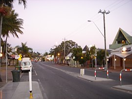
Airlie Beach, Queensland
| Airlie Beach Queensland | |||||||||||||||
|---|---|---|---|---|---|---|---|---|---|---|---|---|---|---|---|
 Airlie Beach | |||||||||||||||
 Airlie Beach | |||||||||||||||
| Coordinates | 20°16′28″S 148°42′54″E / 20.2744°S 148.715°ECoordinates: 20°16′28″S 148°42′54″E / 20.2744°S 148.715°E | ||||||||||||||
| Population | 1,208 (2016 census)[1] | ||||||||||||||
| • Density | 378/km2 (978/sq mi) | ||||||||||||||
| Postcode(s) | 4802 | ||||||||||||||
| Area | 3.2 km2 (1.2 sq mi) | ||||||||||||||
| Location |
| ||||||||||||||
| LGA(s) | Whitsunday Region | ||||||||||||||
| State electorate(s) | Whitsunday | ||||||||||||||
| Federal division(s) | Dawson | ||||||||||||||
| |||||||||||||||
Airlie Beach is a coastal locality in the Whitsunday Region of Queensland, Australia.[2] In the 2016 census, Airlie Beach had a population of 1,208 people.[1]
Geography[]
Airlie Beach is one of many departure points for the Great Barrier Reef. Cruise ships visit the area, anchoring offshore while passengers are transported via ship's tender to the marina.[3] Near latitude 20 degrees south, Airlie Beach, Proserpine and the nearby Whitsunday Islands enjoy a tropical climate and lifestyle.[4]
Each year the residents of Airlie Beach celebrate The Blessing of the Fleet on Whitsunday or Pentecost Sunday.[5]
History[]
The name derived from the former town of Airlie and unbounded locality of Airlie Beach. Airlie was named following a request by the Lands Department in December 1935 for the Proserpine Shire Council to provide a name for a new sub-division on the coast.[2] It is almost certain that the town was named for the parish of Airlie, in Scotland, as the name was suggested by the chairman of the former Proserpine Shire Council, Robert Shepherd, who was born in nearby Montrose, Scotland. The official name was Airlie from 1936 until 1987, when it was amalgamated into the larger town of Whitsunday while Airlie Beach became the official name of the locality.[2][6]
Airlie Beach Post Office opened on 2 November 1959.[7]
In December 1956, 18 allotments were offered for auction as Perpetual Town Leases by the Department of Public Lands office. The map advertising the auction states the allotments were situated approximately 15 miles north-east of Proserpine.[8]
In recent years there have been shark attacks off the coast of Airlie Beach. In 2018 there was 2 near fatal attacks and the most recent attack occurred on 29 October 2019.[9][10][11]
Airlie Beach has a high number of residents working in the tourism and hospitality industries and in 2020 the town was named one of the most likely Australian towns to suffer for the longest from the economic downturn caused by the 2020 Coronavirus Pandemic.[12]
Population[]
At the 2016 census, the suburb of Airlie Beach itself had a population of 1,208 excluding Cannonvale. 50.9% of people were born in Australia. The next most common country of birth was England at 9.2%. 71.2% of people only spoke English at home. The most common response for religion was No Religion at 34.7% of the population.[1]
Busking[]
Busking was made legal in June 2010 through an adopted draft policy created by Whitsunday Regional Council.[13][14][15][16]
References[]
- ^ a b c Australian Bureau of Statistics (27 June 2017). "Airlie Beach (SSC)". 2016 Census QuickStats. Retrieved 20 October 2018.

- ^ a b c "Airlie Beach (entry 46849)". Queensland Place Names. Queensland Government. Retrieved 14 March 2014.
- ^ "Whitsundays Cruise Port". Archived from the original on 10 April 2019. Retrieved 18 April 2019.
- ^ "Airlie Beach, Australia, climate, Information, rainfall, Map". Auinfo.com. Archived from the original on 18 January 2013. Retrieved 21 June 2013.
- ^ "Blessing of the Fleet". Whitsunday Sailing Club. Archived from the original on 10 September 2017. Retrieved 10 September 2017.
- ^ "Whitsunday – town in Whitsunday Region (entry 37374)". Queensland Place Names. Queensland Government. Retrieved 26 October 2019.
- ^ Phoenix Auctions History. "Post Office List". Phoenix Auctions. Retrieved 20 March 2021.
- ^ "Government sale of seaside allotments, to be offered at auction, as perpetual town leases, at the Land Office, Proserpine.1956 plan of allotments in Section 4, Town of Airlie, Parish of Conway, County of Herbert / drawn by the Survey Office ; A.J. Edmiston, staff surveyor". 6 December 1956. hdl:10462/deriv/282100. Cite journal requires
|journal=(help) - ^ "Two people seriously injured in shark attack at Airlie Beach". Nine News. Retrieved 29 October 2019.
- ^ "Whitsundays shark attack: woman and child bitten in shallow waters". The Guardian. 10 January 2019.
- ^ Natalie Wolfe (8 November 2018). "Crisis talks to be held over horror Whitsundays shark attacks". news.com.au.
- ^ "Byron Bay, Cairns 'most vulnerable' to lasting COVID-19 damage". www.abc.net.au. 14 April 2020. Retrieved 26 July 2021.
- ^ "He's breaking the law by busking". Dailymercury.com.au. 13 July 2010. Archived from the original on 4 March 2012. Retrieved 21 June 2013.
- ^ Ben Glover (25 February 2010). "The busking blues". Whitsunday Times. Archived from the original on 4 March 2012. Retrieved 21 June 2013.
- ^ James Tolmie (22 July 2010). "Busker happy with decision". Whitsunday Times. Archived from the original on 4 March 2012. Retrieved 21 June 2013.
- ^ James Tolmie (2 September 2010). "Busker still not happy with rules". Whitsunday Times. Archived from the original on 4 March 2012. Retrieved 21 June 2013.
External links[]
| Wikivoyage has a travel guide for Airlie Beach. |
| Wikimedia Commons has media related to Airlie Beach, Queensland. |
- "Airlie Beach". Queensland Places. Centre for the Government of Queensland, University of Queensland.
- Whitsunday Shire Council
- Towns in Queensland
- Coastal towns in Queensland
- Seaside resorts in Australia
- North Queensland
- Beaches of Queensland
- Whitsunday Region
- Coastline of Queensland
- Localities in Queensland
