Proserpine, Queensland
| Proserpine Queensland | |||||||||||||||
|---|---|---|---|---|---|---|---|---|---|---|---|---|---|---|---|
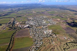 Aerial image of Proserpine | |||||||||||||||
 Proserpine | |||||||||||||||
| Coordinates | 20°24′6″S 148°34′53″E / 20.40167°S 148.58139°ECoordinates: 20°24′6″S 148°34′53″E / 20.40167°S 148.58139°E | ||||||||||||||
| Population | 3,562 (2016 census)[1] | ||||||||||||||
| • Density | 141.91/km2 (367.6/sq mi) | ||||||||||||||
| Established | 1890s | ||||||||||||||
| Postcode(s) | 4800 | ||||||||||||||
| Elevation | 20 m (66 ft)[2] | ||||||||||||||
| Area | 25.1 km2 (9.7 sq mi) | ||||||||||||||
| Time zone | AEST (UTC+10) | ||||||||||||||
| Location | |||||||||||||||
| LGA(s) | Whitsunday Region | ||||||||||||||
| State electorate(s) | Whitsunday | ||||||||||||||
| Federal Division(s) | Dawson | ||||||||||||||
| |||||||||||||||
| |||||||||||||||

Proserpine (/ˈprɒsərpaɪn/)[3] is a town and a locality in the Whitsunday Region, Queensland, Australia.[4][5] The town was settled by Europeans in the 1890s. At the 2016 census, Proserpine had a population of 3,562.[6][7]
History[]
The Gia people are the traditional Aboriginal Australians of the Proserpine area. Giya (also known as Kia. See also related Birri languages) is a language of North Queensland. The Giya language region includes the landscape within the local government boundaries of the Whitsunday Regional Council, particularly the towns of Bowen and Proserpine.[8]
George Elphinstone Dalrymple named the Proserpine River on an expedition in 1859.[9] Proserpine derives from the legend of the Greek goddess Persephone (whose Latin name is Proserpine).[6]
The first British colonists arrived in the early 1860s with Daniel Emmerson forming the Proserpine pastoral station. Frederick Bode and William Dangar took up land at Bromby Park and Goorganga Creek, while Charles Bradley and James "Terrible Jimmy" Colling established properties along the Gregory River.[9]
Two of these pioneers were known to shoot Aboriginal people at "the slightest provocation."[9] In 1866, Inspectors John Marlow and John Isley of the Native Police, a government funded paramilitary organistion,[10] conducted patrols through the Proserpine area. They and their troopers "dispersed" around six "large mobs" of Aboriginal people during this mission.[11] Marlow used Daniel Emmerson's property for his stock-yard and bought horses from him.[12] After the spearing of cattle at Goorganga Plains, some Aboriginal people were giving "a very salutary lesson."[13] In 1875 after the killing of a settler named Ben Toll and several of his workers at Lethebrook, the local colonists rounded up a group of Aboriginal people and killed them at Slaughter Waterhole.[9] When Albert Setter was attacked and wounded with spears in 1883 while transporting goods through Crystal Brook, Native Police troopers and local settlers conducted probably the last punitive expedition in the area resulting in a "wholesale massacre."[9] Setter lived to an old age and died in Proserpine in 1951.[14]
The Crystal Brook Sugar Company was formed in 1882 and established a sugar industry in the region a year later. A sugar mill was built and the labouring on the plantation was performed by imported South Sea Islanders. In 1893 the plantation, which was located at Glen Isla close to the present Proserpine township, was closed and smaller sugar farms run by white owner-operators were established.[9]


The township of Proserpine was created in the 1890s. The Postal Office opened in 1886. The town experienced high growth in the 1900s as the local sugar industry grew and exported raw sugar via the Proserpine Landing from here it was sent to refineries.
In 1944 the Australian Field Experimental Station was constructed at Gunyarra just south of the town, this accommodated 600 staff from the AIF, AMF, RAAF, Australian Women's Army Service (AWAS), Australian Army Medical Women's Service (AAMWS), Women's Auxiliary Australian Air Force (WAAAF), United Kingdom (UK) Royal Army Medical Corps (RAMC), UK scientists from Porton, England, Australian civilian scientists, and observers from New Zealand Navy, South African Army, United States, and Australian Chemical Defence Board. It was constructed to test and research the effectiveness of Mustard Gas in tropical conditions.[15][16]
In the 1950s the Proserpine Airport was opened which increased the towns accessibility by air. In 1986 construction commenced on the Peter Faust Dam 25 kilometres (16 mi) north-west of the town to be used for flood mitigation during the wet season and irrigation during the dry, the dam was completed in 1990 and was expected to take decades to fill but a passing cyclone helped boost levels close to maximum capacity. The 1990s saw the Proserpine Sugar Mill crush a record amount of cane in 1996.
The Proserpine Library opened in 1998 and had a major refurbishment in 2011.[17]

Heritage listings[]
Heritage-listed sites include:
- Herbert Street: Proserpine Hospital[18]
- Main Street: St Paul's Anglican Church[19]
Geography[]
Proserpine is situated on the Bruce Highway.
The town is located along the banks of the Proserpine River and is surrounded by vast flat areas of land currently primarily used for sugarcane farming and urban expansion. Clarke Range is located to the west, Dryander National Park is to the north, and to the east is Conway National Park.
The Clarke Range to the west of the town contains the small, former gold mining town of Dittmer and provides a backdrop to the area.
Climate[]
The town has a dry-winter humid subtropical climate (Köppen climate classification: Cwa), similar to nearby Mackay.
A cyclone shelter was constructed in February 2013 at Proserpine State Primary School and was a joint project between the Queensland Government and the Government of the Emirate of Abu Dhabi, the latter committing $30 million towards the program.
| hideClimate data for Proserpine Airport | |||||||||||||
|---|---|---|---|---|---|---|---|---|---|---|---|---|---|
| Month | Jan | Feb | Mar | Apr | May | Jun | Jul | Aug | Sep | Oct | Nov | Dec | Year |
| Record high °C (°F) | 41.2 (106.2) |
40.4 (104.7) |
37.9 (100.2) |
34.0 (93.2) |
32.0 (89.6) |
32.0 (89.6) |
32.7 (90.9) |
34.1 (93.4) |
36.3 (97.3) |
39.0 (102.2) |
41.2 (106.2) |
42.9 (109.2) |
42.9 (109.2) |
| Average high °C (°F) | 31.4 (88.5) |
31.1 (88.0) |
30.2 (86.4) |
28.7 (83.7) |
26.5 (79.7) |
24.5 (76.1) |
24.3 (75.7) |
25.6 (78.1) |
28.4 (83.1) |
30.2 (86.4) |
31.4 (88.5) |
32.0 (89.6) |
28.7 (83.7) |
| Average low °C (°F) | 22.6 (72.7) |
22.9 (73.2) |
21.5 (70.7) |
19.1 (66.4) |
15.8 (60.4) |
12.7 (54.9) |
11.0 (51.8) |
11.7 (53.1) |
14.4 (57.9) |
17.5 (63.5) |
19.9 (67.8) |
21.8 (71.2) |
17.6 (63.7) |
| Record low °C (°F) | 15.9 (60.6) |
15.0 (59.0) |
14.2 (57.6) |
7.6 (45.7) |
5.0 (41.0) |
0.5 (32.9) |
−0.9 (30.4) |
0.0 (32.0) |
3.8 (38.8) |
7.4 (45.3) |
13.0 (55.4) |
14.3 (57.7) |
−0.9 (30.4) |
| Average precipitation mm (inches) | 290.1 (11.42) |
381.9 (15.04) |
209.0 (8.23) |
118.3 (4.66) |
70.4 (2.77) |
38.1 (1.50) |
23.7 (0.93) |
25.9 (1.02) |
18.9 (0.74) |
36.2 (1.43) |
88.7 (3.49) |
165.8 (6.53) |
1,473.5 (58.01) |
| Source: [20] | |||||||||||||
Demographics[]

In the 2016 census, Proserpine recorded a population of 3,562 people.
| Year | Population | Percentage +/- |
|---|---|---|
| 1901 | 136 | - |
| 1911 | 1102 | +710.29% |
| 1933 | 2177 | +97.55% |
| 1981 | 3058 | +40.47% |
| 2001 | 3250 | +6.28% |
| 2006 | 3316 | +2.03% |
| 2011 | 3390 | +2.23% |
| 2016 | 3562 | +5.07% |
Facilities and economy[]

Sugar[]

One of the town's main industries is sugar growing. In the north west corner of the Central Business District is a large factory known as the Proserpine Mill. It was established in 1897[21] and is one of the town's biggest employers at the present time. It is now recognised as one of the most modern sugar mills in the world. [22]
Facilities
Proserpine Junior/Senior Sporting Complex is a medium-sized facility located on the western edge of town at the intersection of Crystalbrook and Kelsey Creek Road. Sports that it caters for are junior/senior cricket, soccer and football. Night games can be played at the eastern end of the facility under high-powered halogen lighting. Many events have been held at the facility including the yearly event the Paul Bowman Challenge which celebrated its 10-year anniversary this year, it is a rugby league event and 54 teams from around the region and other surrounding regions participate, it regularly attracts over 1,000 spectators.[23] Recent cricket events include a match involving the Queensland Bulls on 15 September and cricketing greats such as Allan Border, Jimmy Maher, Ian Healy and Michael Kasprowicz were in attendance.[24]
The Proserpine Showground is located in the south-western corner of the town and is used for various events such as auctions, swap meats, car boot sales, softball but the main event that attracts the largest amount of attendees is the Proserpine Show which is held on 24 and 25 June. In 2012, the Proserpine show celebrated 100 years at the showground.[25]
The Whitsunday Raceway motorbike track and dirt riders club is located to the south of the town, these facilities have been constructed for racing, driver training and hosting of competitive events. The facility was opened in 2011 and has hosted the Australian Supermoto Championships. This has helped attract lovers of motorbike racing and dirt riding to Proserpine. The facility is expected to grow in future years as more events are held and support of the club grows.[26] BMW has launched new products at the raceway starting with the BMW G310R in 2017[27]
Education[]
Proserpine has two local public schools: Proserpine State Primary School[28] and Proserpine State High School. There is also a private Catholic school, Saint Catherine's.
Facilities[]
The Proserpine Hospital in Taylor St is the primary health service for the Whitsunday Region .[29]
The town is supplied water by the company SunWater from the nearby Peter Faust Dam that was constructed in 1990 for flood mitigation purposes. The water is treated at the water treatment plant.
Ergon Energy supplies power to the town via the Proserpine Substation complex on Kelsey Creek road which is connected to its main transmission lines.
A new fire and rescue station opened in 2018, this is a major investment in the emergency services in Proserpine. The new facility is on Hinschen Street and replaces the station located in Main Street.
Attractions[]
Prosperine Historical Museum is at 192-198 Main Street (20°24′19″S 148°35′33″E / 20.4054°S 148.5925°E). The museum collects, preserves and presents the history of the Whitsunday region.[30]
Transport[]
Bus[]
There are Whitsunday Transit bus services to and from Airlie Beach and a connection service to Proserpine / Whitsunday Coast Airport. The main bus stations are located in Mill Street (in front of Mill Street Park) and Blair Street (outside of the BP service station).
Air[]
Proserpine Airport has flights to Sydney, Brisbane, and Melbourne. The airport opened in 1951 and the first flight landed at it in November of the same year.
Rail[]
Proserpine is located on the North Coast line and has services between Brisbane and Cairns provided by the Spirit of Queensland which depart from Proserpine station located in Hinschen Street almost at the geographical centre of the town. It was opened on 2 July 1910 and Governor William MacGregor was in attendance having arrived on a special train, the opening was timed to coincide with the Proserpine Show. Regular services to Bowen commenced on 18 July 1910 (was later connected to Mackay and subsequently Brisbane).
Government[]
Proserpine is locally governed by Whitsunday Regional Council, a product of amalgamation of the former Shire of Whitsunday with the former Shire of Bowen. The mayor is Andrew Wilcox. Amanda Camm is the member for the state seat of Whitsunday and George Christensen is the federal member for Dawson.
Media[]
With Proserpine located in the Mackay licence area, the town is served by several radio stations from Mackay which are broadcast to the area through local transmitters at Airlie Beach including the local Hit and Triple M stations, 4MK, Star 101.9, ABC Tropical North, 4CRM and MY105. The ABC's national networks, ABC RN, ABC NewsRadio and ABC Classic are also available in Proserpine on the local Airlie Beach frequencies.
The town receives broadcasts from five television networks—Seven Queensland, WIN (an affiliate of the TEN Network), Southern Cross Nine, ABC TV and SBS. All networks also provide additional digital only television stations. Of the three main commercial networks, only Seven Queensland broadcasts a local news bulletin each weeknight for the Mackay and Whitsundays region which is produced from a local newsroom in Mackay, but broadcast from the network's studio on the Sunshine Coast.
The town's local paper is the Whitsunday Coast Guardian (historically and still known by locals as The Proserpine Guardian) which used to be printed in The Guardian building on Chapman St but is now printed in Townsville.
Notable people[]
- Sam Faust Australian professional rugby league player.
- Andrew Fraser Queensland State Politician.
- Max Grosskreutz Australian speedway rider.
- Travis Waddell Australian professional rugby league footballer, plays for Newcastle Knights[31]
- Lindsay Waddington, Australian country music singer.[32]
See also[]
References[]
- ^ "QuickStats: Proserpine". 2011 Census. Australian Bureau of Meteorology. 21 June 2012. Archived from the original on 6 March 2014. Retrieved 24 July 2012.
- ^ Bureau of Meteorology Archived 2 September 2007 at the Wayback Machine Retrieved 22 November 2007.
- ^ Macquarie Dictionary, Fourth Edition (2005). Melbourne, The Macquarie Library Pty Ltd. ISBN 1-876429-14-3
- ^ "Proserpine – town in Whitsunday Region (entry 27547)". Queensland Place Names. Queensland Government. Retrieved 6 August 2017.
- ^ "Proserpine – locality in Whitsunday Region (entry 46895)". Queensland Place Names. Queensland Government. Retrieved 6 August 2017.
- ^ Jump up to: a b "Proserpine (entry 27547)". Queensland Place Names. Queensland Government. Retrieved 13 March 2014.
- ^ "Proserpine – locality in the Whitsunday Region (entry 46895)". Queensland Place Names. Queensland Government. Retrieved 26 July 2017.
- ^
 This Wikipedia article incorporates CC-BY-4.0 licensed text from: "Indigenous languages map of Queensland". State Library of Queensland. State Library of Queensland. Retrieved 5 February 2020.
- ^ Jump up to: a b c d e f McClements, Mavis I (1 January 1975), A town called Proserpine, Royal Historical Society of Queensland, retrieved 1 November 2020
- ^ Richards, Jonathan (2008). The Secret War: A True History of Queensland's Native Police. University of Queensland Press
- ^ "NORTHERN MEMS". Northern Argus. Queensland, Australia. 27 June 1866. p. 3. Retrieved 1 November 2020 – via National Library of Australia.
- ^ "LIEUT. MARLOW AND THE CONDUCT OF HIS BLACK TROOPERS". The Queenslander. V (251). Queensland, Australia. 26 November 1870. p. 3. Retrieved 1 November 2020 – via National Library of Australia.
- ^ "MURDER BY BLACKS". Daily Mercury. 61 (4959). Queensland, Australia. 13 September 1928. p. 5. Retrieved 1 November 2020 – via National Library of Australia.
- ^ "OBITUARY". The Proserpine Guardian. 46 (2941). Queensland, Australia. 3 August 1951. p. 1. Retrieved 1 November 2020 – via National Library of Australia.
- ^ "Australian Field Experimental Station, Gunyarra, near Proserpine in north Queensland, during WW2". www.ozatwar.com. Archived from the original on 31 March 2016. Retrieved 8 March 2019.
- ^ "An aerial view of the Australian Field Experimental Station camp built at Gunyarra, Qld, 12 miles ..." www.awm.gov.au. Retrieved 8 March 2019.
- ^ "Public Libraries Statistical Bulletin 2016-17" (PDF). Public Libraries Connect. State Library Queensland. November 2017. Archived (PDF) from the original on 30 January 2018. Retrieved 31 January 2018.
- ^ "Proserpine Hospital (entry 601573)". Queensland Heritage Register. Queensland Heritage Council. Retrieved 16 July 2013.
- ^ "St Paul's Anglican Church (entry 601589)". Queensland Heritage Register. Queensland Heritage Council. Retrieved 1 August 2014.
- ^ "PROSERPINE AIRPORT". Climate statistics for Australian locations. Bureau of Meteorology. January 2014. Retrieved 29 January 2014.
- ^ "Proserpine Sugar Mill". 2006 Proserpine Co-operative Sugar Milling Association Limited. Archived from the original on 21 March 2012. Retrieved 18 March 2012.
- ^ "Guide to Proserpine in QLD". Sydney Morning Herald. Archived from the original on 30 September 2009. Retrieved 24 July 2012.
- ^ "Paul Bowman Challenge". SportsTG. Archived from the original on 26 September 2017. Retrieved 26 September 2017.
- ^ "Cricket legends play in Prossie". Queensland Times. 15 September 2017. Archived from the original on 16 January 2018. Retrieved 26 September 2017.
- ^ "Show Whitsunday". 2010 Proserpine A.P. & I. Inc. Archived from the original on 31 May 2011. Retrieved 18 March 2012.
- ^ "Whitsunday Motor Sport opens arms to everyone". Whitsunday Times. Archived from the original on 6 May 2018. Retrieved 6 May 2018.
- ^ "BMW unleashes new bike on Proserpine track". Mackay Daily Mercury. Archived from the original on 7 May 2018. Retrieved 6 May 2018.
- ^ "Opening and closing dates of Queensland Schools". Queensland Government. Retrieved 18 April 2019.
- ^ "Whitsunday Health service Proserpine Hospital Campus Profile". Archived from the original on 14 July 2012. Retrieved 17 August 2012.
- ^ "Home". Proserpine Historical Museum. Retrieved 20 April 2021.
- ^ "Proserpine's Waddell named in Broncos squad". Whitsunday Times. Archived from the original on 8 February 2018. Retrieved 8 February 2018.
- ^ "Country music legend still calls Prossie home". Whitsunday Times. Archived from the original on 8 February 2018. Retrieved 8 February 2018.
External links[]
| Wikimedia Commons has media related to Proserpine, Queensland. |
- "Proserpine". Queensland Places. Centre for the Government of Queensland, University of Queensland.
- Whitsunday Regional Council
- Proserpine Museum
- Town map, 1972
| show Authority control |
|---|
- Towns in Queensland
- Proserpine, Queensland
- Whitsunday Region
- Localities in Queensland