Allèves
Allèves | |
|---|---|
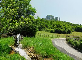 A view of the towers of Saint-Jacques, in Allèves | |
 Coat of arms | |
show Location of Allèves | |
 Allèves | |
| Coordinates: 45°45′10″N 6°04′52″E / 45.7528°N 6.0811°ECoordinates: 45°45′10″N 6°04′52″E / 45.7528°N 6.0811°E | |
| Country | France |
| Region | Auvergne-Rhône-Alpes |
| Department | Haute-Savoie |
| Arrondissement | Annecy |
| Canton | Rumilly |
| Intercommunality | CA Grand Annecy |
| Government | |
| • Mayor (2020–2026) | Noëlle Delorme[1] |
| Area 1 | 8.81 km2 (3.40 sq mi) |
| Population (Jan. 2018)[2] | 415 |
| • Density | 47/km2 (120/sq mi) |
| Demonym(s) | Allevains, Allevaines |
| Time zone | UTC+01:00 (CET) |
| • Summer (DST) | UTC+02:00 (CEST) |
| INSEE/Postal code | 74004 /74540 |
| Elevation | 480–1,621 m (1,575–5,318 ft) |
| 1 French Land Register data, which excludes lakes, ponds, glaciers > 1 km2 (0.386 sq mi or 247 acres) and river estuaries. | |


Allèves (French pronunciation: [alɛv]; Arpitan: Alève) is a commune in the Haute-Savoie department in the Auvergne-Rhône-Alpes region in south-eastern France.
Geography[]
The village is located above the right bank of the Chéran, which forms the commune's southern border.
See also[]
References[]
- ^ "Répertoire national des élus: les maires". data.gouv.fr, Plateforme ouverte des données publiques françaises (in French). 2 December 2020. Retrieved 7 December 2020.
- ^ "Populations légales 2018". INSEE. 28 December 2020.
| Wikimedia Commons has media related to Allèves. |
This Haute-Savoie geographical article is a stub. You can help Wikipedia by . |
Categories:
- Communes of Haute-Savoie
- Haute-Savoie geography stubs