Glières-Val-de-Borne
Glières-Val-de-Borne | |
|---|---|
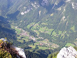 A general view of Le Petit-Bornand-les-Glières | |
Location of Glières-Val-de-Borne  | |
 Glières-Val-de-Borne | |
| Coordinates: 46°00′02″N 6°23′46″E / 46.0006°N 6.3961°ECoordinates: 46°00′02″N 6°23′46″E / 46.0006°N 6.3961°E | |
| Country | France |
| Region | Auvergne-Rhône-Alpes |
| Department | Haute-Savoie |
| Arrondissement | Bonneville |
| Canton | Bonneville |
| Intercommunality | Faucigny-Glières |
| Government | |
| • Mayor (2020–2026) | Christophe Fournier |
| Area 1 | 73.12 km2 (28.23 sq mi) |
| Population (Jan. 2018)[1] | 1,809 |
| • Density | 25/km2 (64/sq mi) |
| Time zone | UTC+01:00 (CET) |
| • Summer (DST) | UTC+02:00 (CEST) |
| INSEE/Postal code | 74212 /74130 |
| Elevation | 591–2,408 m (1,939–7,900 ft) |
| 1 French Land Register data, which excludes lakes, ponds, glaciers > 1 km2 (0.386 sq mi or 247 acres) and river estuaries. | |


Glières-Val-de-Borne is a commune in the Haute-Savoie department in the Auvergne-Rhône-Alpes region in south-eastern France. It was established on 1 January 2019 by merger of the former communes of Le Petit-Bornand-les-Glières (the seat) and Entremont.[2]
See also[]
References[]
- ^ "Populations légales 2018". The National Institute of Statistics and Economic Studies. 28 December 2020.
- ^ Arrêté préfectoral 27 June 2018 (in French)
| Wikimedia Commons has media related to Glières-Val-de-Borne. |
This Haute-Savoie geographical article is a stub. You can help Wikipedia by . |
Categories:
- Communes of Haute-Savoie
- 2019 establishments in France
- Populated places established in 2019
- Haute-Savoie geography stubs