Cusy
Cusy | |
|---|---|
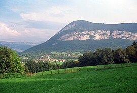 A general view of Cusy | |
 Coat of arms | |
show Location of Cusy | |
 Cusy | |
| Coordinates: 45°45′57″N 6°01′53″E / 45.7658°N 6.0314°ECoordinates: 45°45′57″N 6°01′53″E / 45.7658°N 6.0314°E | |
| Country | France |
| Region | Auvergne-Rhône-Alpes |
| Department | Haute-Savoie |
| Arrondissement | Annecy |
| Canton | Rumilly |
| Intercommunality | CA Grand Annecy |
| Government | |
| • Mayor (2014–2020) | Serge Petit |
| Area 1 | 17.43 km2 (6.73 sq mi) |
| Population (Jan. 2018)[1] | 1,842 |
| • Density | 110/km2 (270/sq mi) |
| Demonym(s) | Cusiard / Cusiarde |
| Time zone | UTC+01:00 (CET) |
| • Summer (DST) | UTC+02:00 (CEST) |
| INSEE/Postal code | 74097 /74540 |
| Elevation | 420–1,365 m (1,378–4,478 ft) |
| 1 French Land Register data, which excludes lakes, ponds, glaciers > 1 km2 (0.386 sq mi or 247 acres) and river estuaries. | |


Cusy (Arpitan: Côsi) is a commune in the Haute-Savoie department in the Auvergne-Rhône-Alpes region in south-eastern France.
Geography[]

The Chéran forms the commune's north-eastern border.
See also[]
References[]
- ^ "Populations légales 2018". INSEE. 28 December 2020.
| Wikimedia Commons has media related to Cusy. |
| show Authority control |
|---|
This Haute-Savoie geographical article is a stub. You can help Wikipedia by . |
Categories:
- Communes of Haute-Savoie
- Haute-Savoie geography stubs